An article by the late meteorologist and broadcaster Philip Eden a number of years ago considered many of these patterns and found that, to varying degrees of reliability, they provided a guide to what the weather would be like at any given time of the year.
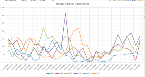
Considering climate change I wondered how much these patterns could still be relied on. Using my own pressure, rainfall and ‘wind run’ data (the total amount of daily wind) going back to the start of 2013 I had a look at the singularities for January and February
January patterns at the beginning, middle and end of the month appear to be the most reliable. However, it is only the ‘mid-Jan settled’ period that is most reliable.
The pressure trace most notably shows a general rise from the 17th, the date of last week’s windstorm, consistent with the mid-January settled singularity.Though this year’s ‘settled’ January spell saw rain the past 5 years have seen mostly dry weather.Very little wind has been recorded around January 20th for the past 5 years
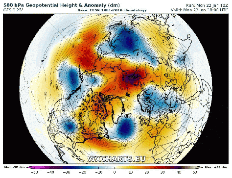
The early Feb settled spell occurs with very low probability: just 56 per cent. And this year the pressure, according to the GFS model, plotted below by WXCharts.eu, is predicted to be around 1040mb by February 2!
This animation of the GFS model shows the idea of the Iceland low, which drives our SW’ly type weather, ‘taking a holiday’ to southern Iberia, possibly advecting any cold weather in the east to flood the UK
Looking at the results of the past 5 years it could be concluded that the patterns do still occur but because of the nature of the jet stream, which seems to meander far more readily than in the past, these stormy / quiet episodes are becoming shorter than they were in previous studies.
The knife-edge situation for snowfall across England today set me off wondering if there was a way to forecast snow locally to a given location.
Temperature, dew point and altitude are all crucial to forecasting snow, as is precipitation intensity that can lower the wet bulb temperature, the ‘rain turning to snow’ scenario. Less well known is the role air pressure plays in these events, such as the one on December 10th which caught many forecasters by surprise by its intensity.
While various models continually improve in their skill at warning us of impending rain / snow events that often cause chaos, their resolution can still struggle and especially when the event more or less becomes a nowcast.
In the International Standard Atmosphere (ISA) there is a 1 hPa difference for each 30 feet vertical change in height in the lower levels.
If we take a forecast pressure as 970 hPa, the difference between standard conditions (1000 hPa) and 970 hPa is thus: 30 hPa
30 hPa * 30 = 900ft height variation.
You then consider local altitude: in my case 18m (59ft)
So 59ft – 900ft = 841ft (256m)
A simple table, therefore, to consider air pressure is thus.
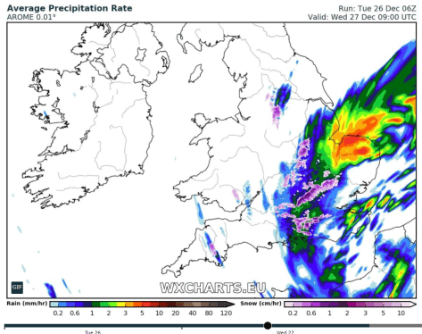
Looking at the system today the pressure rose quickly after the centre passed, leading to a 1hr (at best) window of snow falling. As the pressure rose, and the temperature picked up only slightly the snow turned back to sleet and then rain.
Pressure rose quickly on the 27th, far more rapidly than the 10th – the pressure on this day stayed below 976mb from 8am until 3pm, allowing snow to accumulate. Temperature on the day was also around 0.5C cooler
Pressure fell to its lowest point 970.3mb at 1159z on the 10th
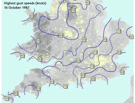
This month marks the 30th anniversary of the Great Storm. Some 18 people were killed as winds gusting to nearly 100mph affected London and the South East. Around 15 million trees were lost with Sevenoaks in Kent losing six of its seven historic trees.
Courtesy of the Met Office
The rapid development of ‘Low M’ took forecasters by surprise, the favoured outcome was for the low to move up through Brittany, remaining in or to the south of the English Channel.
I was living in a fairly sheltered corner of the London borough of Havering in 1987. I remember heavy rain just before midnight, around three hours before the storm reached its height, was heavy enough to send water trickling into my room, thanks to an overflowing roof valley. I thought it strange that Michael Fish hadn’t mentioned its severity in his lunchtime forecast.
I was awoken around 3.30am by a loud crash. Looking out the window I saw two dustbins flying down the road. You could sense each gust building in strength – the next dislodged a roof tile, sending it crashing on to the family car. By this point my mum and sister had awoken, my sister swearing she could feel the whole house moving: Mum ordered us downstairs. By this point the power had gone off and we sat listening to a small battery-operated transistor radio. We listened to updates from BBC Radio London where, like most other people, nobody knew what the hell was going on. The storm continued and first light gradually revealed the damage in the garden – a couple of trees over and next-door’s shed on its side; nothing compared to the rest of the region. But the disruption meant I didn’t attend school that day.
The storm was obviously a weather nut’s dream, and following so close on the heels of the coldest January I can remember. John Hall, of Surrey, can remember the storm well: “I’m not normally a very heavy sleeper, but I somehow managed to sleep through the worst of it (in Cranleigh, then as now).
“It was still windy when I woke around 7 am, but presumably not nearly as much as it had been earlier. By some miracle we still had mains power, and it was only when I switched on the radio and there was no sign of Radio 4 that I realised that something was up. (I assume the transmitter must have been damaged.) I walked the half-mile to the centre of the village to get my morning paper and then to catch the bus to Guildford station for my journey to work.
“It was only then that I learnt from the newsagent that there were no papers and wouldn’t be any buses, as every road in and out of the village was blocked by fallen trees. So I went home, switched on the TV and learnt all about what had happened.”
Dave Cornwell, of Laindon, south Essex, said: “Quite exciting but scary for me at home in Laindon. I awoke probably around 3.00 am to the sound of a metal dustbin lid (remember those?) flying down the street.
“Things sounded pretty bad and my sixth sense told me this was no ordinary windy night. I got up and looked outside and there was stuff flying by and lots of strange noises. One was my plastic gutter blown down and banging against the side of the house. I can’t be certain of the timings but we awakened our two young daughters and took them downstairs as I was worried as they slept in a room with a flat roof dormer window and there was a tall brick chimney stack directly above it. I heard more crashing sounds which unfortunately turned out to be a couple of roof tiles landing on my car roof which was parked in the drive. Of course with no internet then I did what a lot of people did and tuned into the police FM radio network. This gave me a better realisation that it was serious as they were describing the carnage on the roads and all of the emergency calls they and the fire brigade were getting.
“At about 5.30am I ventured out into my driveway to see if there was any serious damage but the storm was still raging and I can honestly say I couldn’t stand up and was unable to keep my balance so went back indoors. I think the wind speed was probably over 100mph at this point being funneled down the side of the house which runs south-north.
“By 8.00 o’clock I was getting ready for work and although by then people were being advised to stay at home I worked in a fairly essential service so thought I would give it a try. I managed to get to East London but there was debris everywhere and I saw a car completely crushed by a one of many trees that were blocking some side roads.
“Another thing I noticed that evening was my south facing windows had a layer of salt on them which must have been blown in from the south coast 60 miles away. It was a sight I’ll never forget and to this day I don’t like strong winds (had a scary flight at Heathrow in a severe gale as well) and always get a nervous feeling if I hear the wind getting up. Probably the most dangerous weather I have experienced anywhere in my lifetime.”
Much has been written about the storm, a ‘once in 500 year event’, including this summary by the Met Office. There is also an excellent paper by Bob Prichard published in Weather. The synoptic charts below show how Low M develops from 1200 on the 15th to 1800 on the 16th.
15OCT87 1200
15OCT87 1800
15OCT87 2400
16OCT87 0600
16OCT87 1200
16OCT87 1800
Because of widespread power cuts many television viewers didn’t see this recording of ITV’s Good Morning Britain at the time of transmission. A round up of the immediate aftermath of the storm, including comments from Jack Scott, can be seen in this edition of Thames News.
The following Daily Weather Report was published by the London Weather Centre:
An intense, and almost certainly exceptional, depression crossed the coast of south Devon soon after midnight, moving quickly, and deepening rapidly, with a track across the Midlands and out towards the Humber Estuary, leaving the United Kingdom land area around 0700 hours.
Some very severe conditions due to storm force winds were generated around the southern and eastern flank of the low, with gusts from approximately 0200 hours well in excess of 70 knots, and reaching a peak in the period 0300 hours to 0700 hours, with gusts to 90 knots reported from Herstmonceux and St Catherine’s Point in the early hours, and similar value gusts from the Channel Islands. The very stormy conditions were accompanied by some heavy rain, this rain pushing into Scotland and parts of Northern Ireland after dawn.
Clearer weather, on westerly winds, swept across southern Britain, pushing the worst of the stormy winds away into the North Sea. During the afternoon the country settled down to a blustery westerly with some heavy and thundery showers developing in clusters, running especially into western and southern coastal regions and parts of southeast England.
Across Scotland and northern England the skies remained cloudy, with outbreaks of mostly light rain, but troughs enhanced the showers in the northwest later in the evening with heavy rain. It was a rather cold day in most places, although the temperatures were near normal in the southeast.
The storm remains the most severe I have experienced in this part of the UK. The Burns’ Day storm in 1990 brought severe gale force winds in the London area but the low pressure was centred much further north.
The most recent severe windstorm in the London area, the St Jude Day storm of 2013, brought strong winds but nothing on a par with 1987.
15OCT87 2400
25JAN90 1200
28OCT13 0000
The anniversary of the storm, complete with a question and answer session attended by Michael Fish, will be marked at the Royal Met Society’s WeatherLive event in November.
July 2017 was the wettest since 1960. Some 92.3mm of rain were recorded which is 212 per cent of the 1981-2010 average.
Although the opening third of the month saw a continuation of the June heatwave temperatures gradually returned to normal values to leave the mean for the month at 19.2C, that’s 0.7C above average.
With all the rain sunshine totals were down. Some 167 hours were recorded, that’s 87% of average.
Though the rainfall total was impressive it is well short of the record of 164.2mm set in 1834, and is only 35th in the list going back to 1797.
Summary for July 2017
Temperature (°C):
Mean (1 minute) 18.9
Mean (min+max) 19.2
Mean Minimum 14.7
Mean Maximum 23.7
Minimum 9.4 day 12
Maximum 30.5 day 07
Highest Minimum 18.3 day 06
Lowest Maximum 19.0 day 24
Air frosts 0
Rainfall (mm):
Total for month 92.3
Wettest day 30.8 day 11
High rain rate 56.4 day 29
Rain days 10
Dry days 21
Wind (mph):
Highest Gust 17.4 day 27
Average Speed 2.9
Wind Run 2163.5 miles
Gale days 0
Pressure (mb):
Maximum 1024.2 day 16
Minimum 996.8 day 31
Total hours of sunshine 167
In terms of the rest of the summer a look at the ECMWF control run out to 10 days suggests an unsettled start to August with the jetstream centred right over the top of the UK. Things may improve as the Azores high attempts to exert more influence – so perhaps more in the way of sunshine than of late. In terms of heatwaves it is impossible to tell at this range.
Here follows the full weather diary for July. To view full stats follow this link:http://1drv.ms/1kiTuzv
1st: Cloudy but with sunny spells developing, these growing longer in length by evening.
2nd: Sunny with just a few light cumulus.
3rd: Sunny start though with plenty of cloud around, this tending to thicken after lunch with odd spot of rain.
4th: Sunny and very warm early then tended to cloud over before sun returned in the late afternoon and evening. Some very unstable low to mid level cloud.
5th: Sunny with just a few cirro-cumulus. Feeling very warm with cloud bubbling up in the evening, however forecast storms failed to materialise.
6th: Sunny with cirrus and dotted cumulus. This tended to thicken late morning though sun stayed out and became hot and humid.
7th: Sunny with lots of high-level cirrus and cumulus most of the day.
8th: Bright but mostly cloudy start, the cloud tending to vary through the day. Sunny after 4pm. Warm overnight.
9th: Bright but mostly cloudy start, the cloud tending to break and vary through the day.
10th: A mostly sunny morning and lunchtime until 2pm when it clouded over.
11th: Cloudy with some bright breaks at first. Cloud thickening with rain by noon, this falling sporadically before getting going after 5pm and stopping by 3am.
12th: Cloudy, damp and close start.
13th: Sunny with variable cloud until noon when there were just bright spells.
14th: Cloudy but with a few breaks around mid morning. Turning cloudy again before sunny spells in the evening.
15th: Cloudy with some sporadic rain as warm front blew through and close. Very limited brightness.
16th: Cloudy with some bright spells. Feeling warm and humid.
17th:Sunny with just a few cirrus drifting around. Feeling hot, cloud thickened from the west in the late afternoon.
18th: Sunny with variable cirrus and cirro cumulus through the day. Feeling very warm. Storms began building with supercell to west of London and over Chilterns.
19th: Cloudy, dull start and very humid with heavy mist – the cloud tended to lift to give sunny spells in the afternoon.
20th: Drizzle after shower before obs time, then showers through to 1pm.
21st: Cloudy start but with sunny spells developing. Clouded over in evening with intermittent heavy rain at 11pm and through the early hours.
22nd: Cloudy but with sunny intervals developing around noon. Heavy showers developing with thunder at 2.30pm and 3.07pm.
23rd: Bright with variable cloud
24th: Cloudy with light, showery rain from northerly airstream that originated in the Med.
25th: Cloudy with light rain just after obs time.
26th: Cloudy with occasionally rain. Feeling warm and a late clearance. Breezy and chilly overnight.
27th: Cloudy but bright and sunny spells developing. A very heavy shower at 1pm.
28th: Bright start but clouding over.
29th: Sunny start with cloud increasing after noon to leave overcast before patchy rain moved in. This falling more heavily at 5pm before clearing to further showers. More rain overnight before a strong squall arrived at 2.45am and lasted an hour with further bursts of rain through the night – two claps of thunder and lightening during squall.
30th: Sunny with variable cloud through the day. Very warm in the sunshine
31st: Sunny with variable cloud throughout the day.
I’ve seen this phrase uttered more than once over the past couple of days thanks to high temperatures and humidity. But ask anyone to define a hot day and you’ll get a different answer every time.
Growing up in the 1970s / 80s redtop newspapers would use the phrase once the mercury was nudging 80F (26.7C). But to ‘scorch’ you need sunshine, preferably at least 10 hours of it. Considering statistics from the Heathrow airport climate station in west London there have been 463 scorchers since 1959, the most recent happening on July 5th with 29.5C recorded and 13.9 hours of sunshine. There have now been 9 scorchers this year, already matching the number that were recorded in 2014 and only 3 short of last year.
But even with last month’s heatwave this year has some way to go, however, to match the amount measured in 1976 and 1995: 31 days!
December 2016 was the driest 12th month in over 80 years and the 5th driest in a record going back to 1797.
Christmas day was the second warmest on record in London
The total fall of 8.3mm is just 16 per cent of what normally falls in December, marginally more than December 1933. The mean temperature of 6.1C was 0.5C above average, though 4C colder than the record December last year.
There were 51hrs of sunshine, that’s 125 per cent of average.
The wettest day was on the 10th when 5.2mm of rain fell. The warmest day occurred on the 9th with 14.2C recorded. The lowest temperature occurred on the 28th when the spirit fell to -4C.
The sunniest days were on the 4th and 29th when seven hours of sunshine were recorded.
Air frosts: 8, Ground frosts: 14
Fog, frost and black ice all featured during December
Though January has started on the chilly side in the short term the weather will turn mild. Beyond that there is a suggestion that the weather could turn on the colder side of average with some models suggesting a cold snap with snow around mid-month.
My usual method of prediction to the end of the month has been scotched by the very dry December. The only years that were similar were both far colder than last month – the usual pattern of a dry month being cold or very cold was broken.
With the unprecedented warmth at the North Pole, last year’s odd behaviour of the QBO and a weak polar vortex we are in unprecedented territory in terms of what could happen later in January. My hunch, though, suggests the month will end up average to rather cold with little precipitation. Any cold spell with probably be the short-lived variety with a couple of inches of snow that lasts three days.
So, to sum up, we’re looking at a mean of 4.4C, rainfall: 55mm, sunshine: 39hrs.
In view of the above my forecast last month was very poor: predicted mean 4.4C (result 6.1C). Rainfall: 55mm (result 8mm). Sunshine: 39hrs (result 51hrs)
I have also published a winter forecast covering the London area that you can find here.
Here follows the full weather diary for December…Full stats for the month here:http://1drv.ms/1rSfT7Y
1st: Sunny start though the frost lifted readily into low cloud and mist to leave a chilly afternoon.
2nd: Cloudy, quiet and cool weather all day.
3rd: Cloudy and quiet all day. Feeling cold.
4th: Sunny , frosty start. Quickly warming up to leave sunny, cloudless afternoon.
5th: Sunny start, then patchy cloud – this thickening before becoming foggy overnight.
6th: Misty start after fog overnight. Cloudy most of the day though there was a brief clearance around midday.
7th: Cloudy most of the day though there was occasional brightness.
8th: Dull day though with a little limited brightness early afternoon.
9th: Cloudy but wth more brightness than yesterday. Very mild. Cloud thickened with light rain around 11am. This gradually grew heavier as the day progressed and was moderate overnight.
10th: Bright start and feeling mild, then cloudier and damp.
11th: Cloudy and dull all day.
12th: Dull all day with light rain early and late. Clearer spells overnight but overcast again by dawn.
13th: Dull with bits and pieces of drizzle up to 11.20am.
14th: Bright start with lots of cirrus and altocumulus – this gradually cleared to leave a warm and pleasant afternoon.
15th: Dull and cloudy with limited brightness.
16th: Dull and cloudy start.
17th: Foggy and dull all day.
18th: Misty start with fog above 90m on cycle ride. Then dull and grey all day. Mild.
19th: Dull and cloudy all day – some spots of drizzle.
2oth: Sunny start but clouded over late morning. Cloudy thereafter with some drizzle overnight.
21st: Cloudy start then sunny. Cloud returned and turned dull and dreary in the afternoon with odd drizzle.
22nd: Bright, misty start
23rd: Cloudy start with breeze beginning to build as a result of Storm Barbera.
24th: Cloudy and dull all day. Very mild. Temp increasing overnight with approach of warm front .
25th: Cloudy, breezy start. Remained dull all day though brightness was seen over the Thames and North Downs, disrupting the SW’ly flow.
26th: Sunny, hazy start and turning colder.
27th: Sunny, frosty start, the air pressure record of 2012 has been broken.
28th: Foggy start, the fog persisting to late morning before sun broke through leaving a chilly afternoon. Frost returned quickly after dark, a clear night.
29th: Sunny and very cold and frosty start. Frost returning after dark with fog forming in the early hours.
30th: Foggy and dull all day, the fog thickening up at nightfall. Approaching cloud lifted the fog and temperature.
31st: Dull and overcast to start – this sticking around all day.
Earthquakes in Italy and early season snow cover in Siberia have been well documented in 2016.
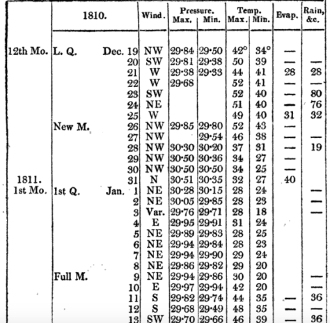
They were also mentioned by Luke Howard in his publication The Climate of London in 1810.
He also mentions winter thunderstorms over the Yuletide period, from Christmas Eve to Boxing Day – the amount of rain overflowing the Thames.
24th: Very windy night with heavy rain. 25th: Wind high all day with rain frequent lightning in the evening from SE. 26th: Wind very boisterous early in the morning day fine the rain of the last three or four days being impeded in its passage to the Thames by the spring tides overflowed the banks and filled the marshes.
Within two days of this wild and wet spell, complete with strong north-westerlies, the wind swung north and then north-easterly to usher in 1811 with a 12-day cold spell.
The conditions of the cold spell were not severe, the coldest night was -8C, it was a pretty standard cold spell for the time and one that the south-east used to experience with fair regularity in the early to mid 1980s.
Models currently show a (fairly) narrow chance of a stormy Christmas period. It would be interesting if it were followed with a cold spell in January – just like the ones we used to get in 1980s.
* The Booty website also contains the following on that notable month…
What is thought to be Britain’s strongest tornado occurred in December 1810. A category of “T8” (on a ten-point scale) occurred on the 14th at Old Portsmouth. The TORRO website says it: “tracked from Old Portsmouth to Southsea Common causing immense damage – although no deaths, it is believed. Some houses completely levelled and many others were so badly damaged that they had to be demolished; chimneys were blown down and the lead on a bank roof was ‘rolled up like a piece of canvas and blown from its situation’.”
November 2016 was the sunniest in a record going back to 1881. Some 91 hours were recorded, 156 per cent above average and a complete contrast to last November which was the dullest for 47 years.
The temperature in the early hours of the 30th fell to -6.1C, colder than any night last winter and the coldest since January 2013
The mean temperature for the month finished 6.4C, that’s 1.5C below the 1981-2010 average ; 4C cooler than last year and the coldest November since 2010. The warmest day occurred on the 15th with 15.9C recorded. The first air frosts of autumn were recorded. The lowest temperature occurred on the 29th when the spirit fell to -6.1C.
Rainfall was 135 per cent of average with 80.1mm recorded. The wettest day was on the 19th when 23.5mm of rain fell.
The sunniest days were on the 2nd, 13th and 25th when eight hours of sunshine were recorded.
Air frosts: 4, Ground frosts: 19
The dolphin-shape of this radar image shows Storm Angus before it hit the south coast. The system stayed far enough south of us not to cause any damage in London
What has December got in store weatherwise? The models suggest the high pressure that has been anchored over us, bringing cold nights, will pull away to the continent. This will allow an ever milder but mostly dry source of air off the Atlantic through to mid month. Days will grow milder while frost and fog will feature less at night.
Beyond the grasp of the models my long range outlook method suggests an coldmonth is most likely at 43 per cent probability. Average comes in at 29 per cent probability while rather mild and rather cold are both 14 per cent probabilities.
Rainfall looks finely balanced. Wetter and dryer than average both come in at 43% probability while average is 14 per cent. Given the influence of high pressure at the beginning of the month I’m inclined to think it will be a drier than average month.
So, to sum up, we’re looking at a mean of 4.4C, rainfall: 55mm, sunshine: 39hrs.
My forecast last month was good: predicted mean 6.8C (result 6.4C). Rainfall: 55mm (result 80mm). Sunshine was way off, however – predicted total: 41hrs (result 91hrs)
I have also published a winter forecast covering the London area that you can find here.
Here follows the full weather diary for November…Full stats for the month here:http://1drv.ms/1rSfT7Y
1st: Cloudy and mild all day. Patchy drizzle at times.
2nd: Sunny, cold start after first ground frost of the autumn.
3rd: Sunny, cold start with cirrostratus and cumulus drifting around. Cloud thickened through the afternoon with some light rain around 9pm.
4th: Cloudy, dull start up to 11am. Rain pushed in and lasted for much of afternoon, clearing in evening.
5th: Cloudy, cold and damp start. Some brightness though with a cold wind.
6th: Sunny, cold start, tending to cloud in. Rain after 3pm. Feeling cold but too windy for a frost overnight.
7th: Sunny, cold and very breezy to start, the cloud tending to fill in through the day. Clearer overnight though too much cloud and occasional air prevented an air frost.
8th: Sunny and cold start. Cloud thickened during the day to bring rain after dark at 8pm that then fell through the night – the biggest fall since Brexit day.
9th: Light rain slowly clearing to cloud.
1oth: Cloudy start with light rain showers around 10.30am then cloudy. Some sunny intervals in the afternoon. Milder.
11th: Bright start with cloud decreasing through the morning to leave a pleasant and clear afternoon.
12th: Miserable and rainy to start, this lasting past 11.15am. Drizzle thereafter into 6pm.
13th: Sunny start though cloud tended to fill in through the day. Damp overnight with patchy drizzle.
14th: Cloudy and damp start with some breeze. Brief brightness at noon but patchy drizzle moved in around 4pm.
15th: Cloudy and miserable though very mild.
16th: Sunny start and very mild though cloud tended to fill in during the day making the sunshine milky.
17th: Bright, breezy start, the breeze increasing until a squall blew through at 2.40pm then sunny spells.
18th: Bright start with milky sunshine then tending to cloud over. Feeling cold.
19th: Bright sunshine though cold to start. Patchy altocumulus developed through the day, leaving it to become bright, the strength of the sun diminishing. Rain started around 6pm and fell through night with varying intensity.
20th: Dull and cloudy start with rain returning at 10am. Cloudy afternoon with rain returning late evening and through the night, some heavier bursts.
21st: Cloudy with showers past noon. Heavier showers moved in mid afternoon and fell into the evening.
22nd: Cloudy with a few very light showers around. Breezy.
23rd: Cloudy and breezy. Feeling mild.
24th: Cloudy and mostly dull with brief brightness at noon.
25th: Sunny with just a few cumulus around.
26th: Sunny start but low cloud blotted out the sun around midday then cloudy and cool.
27th: Cloudy and mild.
28th Sunny all day with just a few cumulus floating around.
29th: Sunny all day with frost persisting on grass in shade.
30th: Sunny and very frosty start. Frost persisting on the grass all day with a very cold start to the night. A veil of cloud crossed the region late evening, lifting the temperature above freezing, before clearing before dawn
Frost still lingers on my lawn as I write this winter forecast on the last day of the meteorological autumn. Last night’s minimum was -6.1C, the coldest night this year and, indeed, colder than any night last winter.
It would be very easy to get caught up in the hysteria that happens every November of what the winter will bring. Most of the hysteria comes from ‘coldies’, those folk that hope every winter will be the coldest and snowiest on record. I count myself among them.
The north-west of England looks around 10C above average on December 9
But, despite hints from BBC weather forecasters that something maybe afoot in terms of something colder than usual from mid-December, years of disappointment have taught me to just take winter as it comes. Meteorological models this morning look anomalously warm for the first half of December, the UK being on the warm side of an anticyclone centred over France – the theme of so many winters I can remember.
The current phases of ENSO and QBO suggest that their influence on our winter this year will be far less marked than last year. Looking at teleconnections with a slight La Nina and the current QBO cycle have revealed winters that were fairly uninspiring though by no means write-offs for snow, two examples in the case of QBO being 1985/86 and 1990/91 – both had very cold Februaries.
Before I got too bogged down with trying to find patterns here I decided to move on to my more traditional pattern-matching.
Before I trawled through the figures my initial gut reaction to this winter was that it would be the coldest for at least four years – a not-too-difficult feat giving the mildness of the last three winters which saw very little in the way of snow.
The overall mean temperature for December, January and February came out at as4.2C – 1.2C colder than the 1981-2010 average, with average precipitation.
A rather cold winter, over three months doesn’t tell you much. A very mild and stormy December could mask a dry and notably cold February. This makes it worth looking at the individual months of each winter.
There is a lot of spread in the above tables. Considering them altogether I would guess winter will unfold in the following way:
December to start mild, possibly becoming very mild, before beginning to turn very cold mid-month. This pattern will persist, with varying intensity through into January which could also be very cold. Milder conditions to follow in February though this will probably end a fairly average month and drier after a slightly wetter than average December and average January.
As well as my method of using rainfall and temperature I also considered other methods. One was Russian research that states that the weather pattern in the winter will be the opposite to the weather on September 17th and November 7th. This autumn September 17th was N’ly and November 7th was NNW’ly. So, this would suggest a continental flow from S and SSE.
You can read the method of how I reached my conclusion here.
Last month was the second warmest September in a local record going back to 1797! The monthly mean finished 17.8C, 2.4C above average. Despite being an ‘autumn’ month September was actually a full degree warmer than June!
September 2016 was the second warmest in a local record back to 1797, though we’re talking by fewer than tenths of a degree.
The hottest September day since 1959 was recorded on the 13th when 33.1C was reached, the sixth equal hottest in the local daily record back to 1848.
The month also saw the warmest minimum recorded since 1959 when the mercury failed to fall below 18.7C on the 6th.
It was another very dry month, the third much drier than average month in a row: just 27.7mm fell, 24 per cent of average, making it the driest September since since 2007 and the 12th driest in the local record.
Like August, the month only falls down in terms of impressiveness when sunshine hours are considered. Some 119 hours were recorded, that’s 85 per cent of average, making it the dullest September for 15 years.
Air frosts: 0, Ground frosts: 0
So what has September got in store weatherwise? The models on the 1st suggest that a large Scandinavian high will become established to our NE bringing lots of settled weather and showers on coasts. There’s obviously the chance of trough disruption as the month progresses if the anticyclone’s influence declines.
Beyond the grasp of the models my usual long range outlook method falls down this month due to September’s warmth and dryness – there is nothing within +/- 10% of September’s statistics. I would guess, however, that we are looking at another drier than average month with frost becoming a risk as the month progresses where skies clear. There is also the chance of more pleasant autumn days where skies are clear during the day.
My September outlook for temperature was poor. I predicted a mean of 15.3C (outcome: 17.8C). It was much, much drier than I thought: 300mm (outcome: 27.7mm). Sunshine was poor: 140 hours (outcome: 119 hours).
Here follows the full weather diary for September…Full stats for the month here:http://1drv.ms/1rSfT7Y
1st: Sunny start but cloud gradually increased until it was overcast by 6pm. Clear spells overnight but warmer than previous nights.
2nd: Cloudy though some brighter intervals.
3rd: Sunny start, cloud began to pile in at 12.30pm with rain arriving at 5.30pm, this fell through the evening with some showers in the early hours.
4th: Bright, breezy start but rapidly turning cloudy and dull. Some rain overnight.
5th: Light rain and dull to start – this quickly clearing to cloud by 3pm. Things remained cloudy with a muggy night.
6th: Cloudy, dull and muggy start after warmest September night on record. Another warm night though muggy.
7th: Cloudy to 11am though sun breaking through as drier air arrived. Feeling humid.
8th: Sunny start but with plenty of cumulus, this quickly decreasing to leave clear sky.
9th: Cloudy morning though sky seemed to periodically clear of low cumulus before becoming overcast and very breezy in the afternoon. Some rain overnight and just before obs time.
10th: Cloudy start with patchy light rain, this briefly turning heavy at 1pm before turning occasionally moderate. Dreadful afternoon after recently. Clearing overnight to leave a sunny start.
11th: A glorious sunny day with only the odd patch of cirrus.
12th: Bright start with some sunshine, clouding over with a few splodges of rain with warm front. Then sunny and very warm.
13th: Sunny start with a few cirrus and castalanus around. Breezy at times with the thermals. The warmest September day since 1959 and 6th equal warmest since 1848.
14th: Sunny start with a few cirrus. A few patches of alto-cumulus later. Very warm but not as hot as yesterday. Warm, pleasant evening. 15th: Sunny with a few wispy cumulus, clearing to hot sunshine. Some alto-cumulus developed at 2pm and towering cumulus could be seen in distance. Thunderstorms reporting to NW of London. Cloudy and warm overnight with eight peals of thunder in the early hours and heavy rain.
16th: Light to moderate rain through the morning, petering out at 1.30pm.
17th: Cloudy, cool and breezy all day, at times dull.
18th: Cloudy all day, a bit warmer than the previous two days.
19th: Cloudy start though with sun breaking through briefly at 11am until 1pm then cloudy again. Rain at 1am that didn’t last long enough to register.
20th: Cloudy and fairly calm – a nothing day with odd very light drizzle.
21st: Bright start with cloud breaking to long spells of sunshine before more cloud moved in. Warmer than of late.
22nd: Cloudy but sun broke through giving pleasant afternoon and cool overnight.
23rd: Sunny, gin clear and cold start. Just a few fair weather cumulus through the day.
24th: Sunny start with cloud decreasing. Very warm in sun but cloud and breeze built through the day. Overnight light rain between 6am and 9am.
25th: Bright start after overnight light rain.
26th: Bright start with a few cloud breaks here and there. Heavy shower at 12.15pm with further threat of rain but stayed dry.
27th: Bright start with signs of a cold front moving in from south then cloudy.
28th: Sunny start with patchy cirrus, this tending to thicken at lunchtime to turn mostly overcast with humidity increasing. Breeze also picked up with reappearance of sun mid afternoon. Cloudy, very mild and breezy rest of the day.
29th: Cold front and brief heavy rain swept in at 10.03am. Then intermittent falls until 11.23am.
30th: Sunny, gin-clear start, patchy cumulus bubbling up at 10.30am. Cloud grew thicker around 12 noon with brief shower at 1pm. Then sunny spells and cloudier periods. Another shower just after nightfall then clear. Cloud moved in after 2am with another shower. Early sunshine gave way to moderate showers around 9.45am.


 The overall mean temperature for December, January and February came out at as
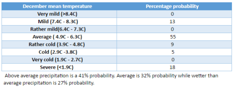


You must be logged in to post a comment.