This year finished as the 14th warmest on record – some 0.5C warmer than the 1981-2010 average – though 0.2C cooler than 2015.
Only four months of 2016 were below average temperature-wise
Six months of 2016 were roughly average – the means being within +/-0.7 every month, bringing the mean temperature to 11.7C.
Rainfall was less remarkable with the year being a little drier than average. The total of 561mm (93% of 1981-2010 average) puts it as the 122nd wettest since 1797, just 8mm wetter than 2015.
It was also a slightly duller than average year with 1,390 hours of sunshine recorded. That’s 93 per cent of average, the 92nd sunniest since 1881 – the least amount of sunshine for 12 years.
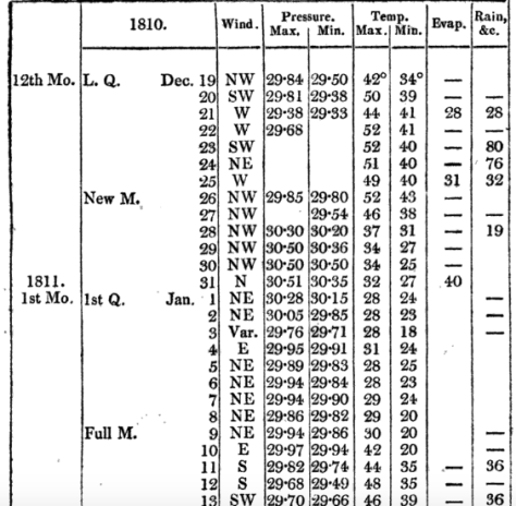
Earthquakes in Italy and early season snow cover in Siberia have been well documented in 2016.
They were also mentioned by Luke Howard in his publication The Climate of London in 1810.
He also mentions winter thunderstorms over the Yuletide period, from Christmas Eve to Boxing Day – the amount of rain overflowing the Thames.
24th: Very windy night with heavy rain. 25th: Wind high all day with rain frequent lightning in the evening from SE. 26th: Wind very boisterous early in the morning day fine the rain of the last three or four days being impeded in its passage to the Thames by the spring tides overflowed the banks and filled the marshes.
Within two days of this wild and wet spell, complete with strong north-westerlies, the wind swung north and then north-easterly to usher in 1811 with a 12-day cold spell.
The conditions of the cold spell were not severe, the coldest night was -8C, it was a pretty standard cold spell for the time and one that the south-east used to experience with fair regularity in the early to mid 1980s.
Models currently show a (fairly) narrow chance of a stormy Christmas period. It would be interesting if it were followed with a cold spell in January – just like the ones we used to get in 1980s.
* The Booty website also contains the following on that notable month…
What is thought to be Britain’s strongest tornado occurred in December 1810. A category of “T8” (on a ten-point scale) occurred on the 14th at Old Portsmouth. The TORRO website says it: “tracked from Old Portsmouth to Southsea Common causing immense damage – although no deaths, it is believed. Some houses completely levelled and many others were so badly damaged that they had to be demolished; chimneys were blown down and the lead on a bank roof was ‘rolled up like a piece of canvas and blown from its situation’.”
Weather models are now in range of predicting the weather on Christmas Day and the all important question of ‘Will it be a white one?’
High pressure centred over the near continent leaves the UK in a feed of very mild air from the Azores
The operational output from the GFS model today answers that question with a resounding ‘no’. A huge anticyclone centred over the continent puts the UK in a very mild SWly feed, the air source from the Azores. You would expect temperatures in London to top around 12C after an overnight low of around 5C.
The Daily Star this morning was even more bullish with it’s splash proclaiming that punters had poured money into Yuletide being exceptionally mild, predicting 15C which would give last year’s record warm period a run for its money. But they have based this forecast on one operational outcome on one model!
Anyone who follows weather forecasts knows that there’s always huge uncertainty in outcomes beyond five days. So putting faith in this forecast 16 days before the event could be dismissed as plain stupid. A closer look at the ensembles – model solutions that pick out trends of several operational runs – suggest that there is very wide spread in outcomes for the weather for Christmas Day: either very cold or very mild! And the GFS system is also hampered by lack of vertical resolution in the stratosphere.
Punters are apparently piling money into it Xmas day being 15C – but ensemble forecasts at this range show outcomes from very mild to very cold.
Taking a broader view of what happens in real life over the last few years there always seems to be a pivotal moment around December 17th. The odds always have to favour the mild weather for us though.
Earlier this month in my November review I found that there was a 55% chance of a cold spell at the end of December. My guess at this range is that the run up to Christmas will see us under the influence of high pressure centred over the near continent – a ‘phantom’ cold spell that is cold at the surface but, at 850mb (5,000ft), well above freezing. Christmas day in London will start frosty with the temperature topping out at 5C or 6C. Any proper cold spell with snow will not bite until 29th.
That’s my guess. My advice to anyone who fancies a flutter is to hold on to your money until the 17th. Or place a bet on both.
* The definition of a white Christmas used most widely – notably by the bookies – is for a single snowflake, even if it lands in the midst of heavy rain, to be observed falling in the 24 hours of 25 December at a specified location recognised by the Met Office.
** On average, snow or sleet falls in the UK 5 days in December, compared with 7.6 days in January, 6.8 days in February and 6 days in March. White Christmases were more frequent in the 18th and 19th centuries, even more so before the change of calendar in 1752, which effectively brought Christmas back by 12 days. Climate change has also brought higher average temperatures over land and sea and this generally reduces the chances of a white Christmas.
November 2016 was the sunniest in a record going back to 1881. Some 91 hours were recorded, 156 per cent above average and a complete contrast to last November which was the dullest for 47 years.
The temperature in the early hours of the 30th fell to -6.1C, colder than any night last winter and the coldest since January 2013
The mean temperature for the month finished 6.4C, that’s 1.5C below the 1981-2010 average ; 4C cooler than last year and the coldest November since 2010. The warmest day occurred on the 15th with 15.9C recorded. The first air frosts of autumn were recorded. The lowest temperature occurred on the 29th when the spirit fell to -6.1C.
Rainfall was 135 per cent of average with 80.1mm recorded. The wettest day was on the 19th when 23.5mm of rain fell.
The sunniest days were on the 2nd, 13th and 25th when eight hours of sunshine were recorded.
Air frosts: 4, Ground frosts: 19
The dolphin-shape of this radar image shows Storm Angus before it hit the south coast. The system stayed far enough south of us not to cause any damage in London
What has December got in store weatherwise? The models suggest the high pressure that has been anchored over us, bringing cold nights, will pull away to the continent. This will allow an ever milder but mostly dry source of air off the Atlantic through to mid month. Days will grow milder while frost and fog will feature less at night.
Beyond the grasp of the models my long range outlook method suggests an coldmonth is most likely at 43 per cent probability. Average comes in at 29 per cent probability while rather mild and rather cold are both 14 per cent probabilities.
Rainfall looks finely balanced. Wetter and dryer than average both come in at 43% probability while average is 14 per cent. Given the influence of high pressure at the beginning of the month I’m inclined to think it will be a drier than average month.
So, to sum up, we’re looking at a mean of 4.4C, rainfall: 55mm, sunshine: 39hrs.
My forecast last month was good: predicted mean 6.8C (result 6.4C). Rainfall: 55mm (result 80mm). Sunshine was way off, however – predicted total: 41hrs (result 91hrs)
I have also published a winter forecast covering the London area that you can find here.
Here follows the full weather diary for November…Full stats for the month here:http://1drv.ms/1rSfT7Y
1st: Cloudy and mild all day. Patchy drizzle at times.
2nd: Sunny, cold start after first ground frost of the autumn.
3rd: Sunny, cold start with cirrostratus and cumulus drifting around. Cloud thickened through the afternoon with some light rain around 9pm.
4th: Cloudy, dull start up to 11am. Rain pushed in and lasted for much of afternoon, clearing in evening.
5th: Cloudy, cold and damp start. Some brightness though with a cold wind.
6th: Sunny, cold start, tending to cloud in. Rain after 3pm. Feeling cold but too windy for a frost overnight.
7th: Sunny, cold and very breezy to start, the cloud tending to fill in through the day. Clearer overnight though too much cloud and occasional air prevented an air frost.
8th: Sunny and cold start. Cloud thickened during the day to bring rain after dark at 8pm that then fell through the night – the biggest fall since Brexit day.
9th: Light rain slowly clearing to cloud.
1oth: Cloudy start with light rain showers around 10.30am then cloudy. Some sunny intervals in the afternoon. Milder.
11th: Bright start with cloud decreasing through the morning to leave a pleasant and clear afternoon.
12th: Miserable and rainy to start, this lasting past 11.15am. Drizzle thereafter into 6pm.
13th: Sunny start though cloud tended to fill in through the day. Damp overnight with patchy drizzle.
14th: Cloudy and damp start with some breeze. Brief brightness at noon but patchy drizzle moved in around 4pm.
15th: Cloudy and miserable though very mild.
16th: Sunny start and very mild though cloud tended to fill in during the day making the sunshine milky.
17th: Bright, breezy start, the breeze increasing until a squall blew through at 2.40pm then sunny spells.
18th: Bright start with milky sunshine then tending to cloud over. Feeling cold.
19th: Bright sunshine though cold to start. Patchy altocumulus developed through the day, leaving it to become bright, the strength of the sun diminishing. Rain started around 6pm and fell through night with varying intensity.
20th: Dull and cloudy start with rain returning at 10am. Cloudy afternoon with rain returning late evening and through the night, some heavier bursts.
21st: Cloudy with showers past noon. Heavier showers moved in mid afternoon and fell into the evening.
22nd: Cloudy with a few very light showers around. Breezy.
23rd: Cloudy and breezy. Feeling mild.
24th: Cloudy and mostly dull with brief brightness at noon.
25th: Sunny with just a few cumulus around.
26th: Sunny start but low cloud blotted out the sun around midday then cloudy and cool.
27th: Cloudy and mild.
28th Sunny all day with just a few cumulus floating around.
29th: Sunny all day with frost persisting on grass in shade.
30th: Sunny and very frosty start. Frost persisting on the grass all day with a very cold start to the night. A veil of cloud crossed the region late evening, lifting the temperature above freezing, before clearing before dawn


You must be logged in to post a comment.