Since October 28th there has been just 1.7 hours of sunshine at Heathrow.
The 12-day spell up to and including November 8th is the dullest at the airport since at least 1960.
If you look further back at other London records, including Kew – a record that includes the years 1912-1940 – there is no other period with as few hours as this year.
A look at the synoptic situation since the end of October shows an anticyclone drifting around the near continent giving us mostly dry, dull and misty weather while also perpetuating the troughs and convergence zones that have brought catastrophic flooding over parts of Iberia and the Balearics.
Note that sunshine data at Kew was missing for the years 1941 and 1943 to 1946.
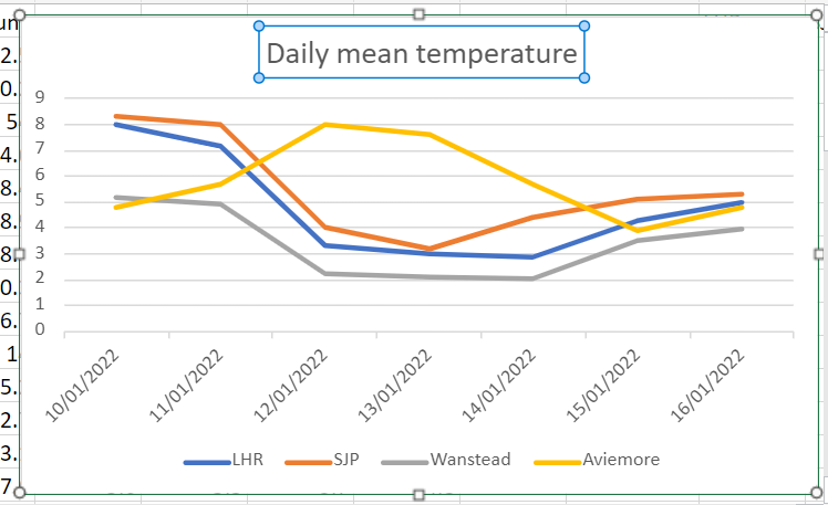
That’s not a statement that applies much, least of all the second week of January. But the current weather pattern has seen this town in the Highlands subject to the warming influence of the Atlantic, to a higher degree than London.
The above 850mb chart, typical of the past week, shows the warmer air aloft and the south of the UK seemingly cut off from outside influence.
Indeed, lack of solar heating at this time of year ensures that any thermal activity is minimal – with very little mixing of the boundary layers by day.
Wanstead Park, being a frost hollow, has seen this phenomena most days during the past week with this part of London markedly colder than elsewhere in the capital.
By the 16th the 7-day running mean at Aviemore was 2.4C higher than Wanstead!
July 2017 was the wettest since 1960. Some 92.3mm of rain were recorded which is 212 per cent of the 1981-2010 average.
Although the opening third of the month saw a continuation of the June heatwave temperatures gradually returned to normal values to leave the mean for the month at 19.2C, that’s 0.7C above average.
With all the rain sunshine totals were down. Some 167 hours were recorded, that’s 87% of average.
Though the rainfall total was impressive it is well short of the record of 164.2mm set in 1834, and is only 35th in the list going back to 1797.
Summary for July 2017
Temperature (°C):
Mean (1 minute) 18.9
Mean (min+max) 19.2
Mean Minimum 14.7
Mean Maximum 23.7
Minimum 9.4 day 12
Maximum 30.5 day 07
Highest Minimum 18.3 day 06
Lowest Maximum 19.0 day 24
Air frosts 0
Rainfall (mm):
Total for month 92.3
Wettest day 30.8 day 11
High rain rate 56.4 day 29
Rain days 10
Dry days 21
Wind (mph):
Highest Gust 17.4 day 27
Average Speed 2.9
Wind Run 2163.5 miles
Gale days 0
Pressure (mb):
Maximum 1024.2 day 16
Minimum 996.8 day 31
Total hours of sunshine 167
In terms of the rest of the summer a look at the ECMWF control run out to 10 days suggests an unsettled start to August with the jetstream centred right over the top of the UK. Things may improve as the Azores high attempts to exert more influence – so perhaps more in the way of sunshine than of late. In terms of heatwaves it is impossible to tell at this range.
Here follows the full weather diary for July. To view full stats follow this link:http://1drv.ms/1kiTuzv
1st: Cloudy but with sunny spells developing, these growing longer in length by evening.
2nd: Sunny with just a few light cumulus.
3rd: Sunny start though with plenty of cloud around, this tending to thicken after lunch with odd spot of rain.
4th: Sunny and very warm early then tended to cloud over before sun returned in the late afternoon and evening. Some very unstable low to mid level cloud.
5th: Sunny with just a few cirro-cumulus. Feeling very warm with cloud bubbling up in the evening, however forecast storms failed to materialise.
6th: Sunny with cirrus and dotted cumulus. This tended to thicken late morning though sun stayed out and became hot and humid.
7th: Sunny with lots of high-level cirrus and cumulus most of the day.
8th: Bright but mostly cloudy start, the cloud tending to vary through the day. Sunny after 4pm. Warm overnight.
9th: Bright but mostly cloudy start, the cloud tending to break and vary through the day.
10th: A mostly sunny morning and lunchtime until 2pm when it clouded over.
11th: Cloudy with some bright breaks at first. Cloud thickening with rain by noon, this falling sporadically before getting going after 5pm and stopping by 3am.
12th: Cloudy, damp and close start.
13th: Sunny with variable cloud until noon when there were just bright spells.
14th: Cloudy but with a few breaks around mid morning. Turning cloudy again before sunny spells in the evening.
15th: Cloudy with some sporadic rain as warm front blew through and close. Very limited brightness.
16th: Cloudy with some bright spells. Feeling warm and humid.
17th:Sunny with just a few cirrus drifting around. Feeling hot, cloud thickened from the west in the late afternoon.
18th: Sunny with variable cirrus and cirro cumulus through the day. Feeling very warm. Storms began building with supercell to west of London and over Chilterns.
19th: Cloudy, dull start and very humid with heavy mist – the cloud tended to lift to give sunny spells in the afternoon.
20th: Drizzle after shower before obs time, then showers through to 1pm.
21st: Cloudy start but with sunny spells developing. Clouded over in evening with intermittent heavy rain at 11pm and through the early hours.
22nd: Cloudy but with sunny intervals developing around noon. Heavy showers developing with thunder at 2.30pm and 3.07pm.
23rd: Bright with variable cloud
24th: Cloudy with light, showery rain from northerly airstream that originated in the Med.
25th: Cloudy with light rain just after obs time.
26th: Cloudy with occasionally rain. Feeling warm and a late clearance. Breezy and chilly overnight.
27th: Cloudy but bright and sunny spells developing. A very heavy shower at 1pm.
28th: Bright start but clouding over.
29th: Sunny start with cloud increasing after noon to leave overcast before patchy rain moved in. This falling more heavily at 5pm before clearing to further showers. More rain overnight before a strong squall arrived at 2.45am and lasted an hour with further bursts of rain through the night – two claps of thunder and lightening during squall.
30th: Sunny with variable cloud through the day. Very warm in the sunshine
31st: Sunny with variable cloud throughout the day.
I’ve seen this phrase uttered more than once over the past couple of days thanks to high temperatures and humidity. But ask anyone to define a hot day and you’ll get a different answer every time.
Growing up in the 1970s / 80s redtop newspapers would use the phrase once the mercury was nudging 80F (26.7C). But to ‘scorch’ you need sunshine, preferably at least 10 hours of it. Considering statistics from the Heathrow airport climate station in west London there have been 463 scorchers since 1959, the most recent happening on July 5th with 29.5C recorded and 13.9 hours of sunshine. There have now been 9 scorchers this year, already matching the number that were recorded in 2014 and only 3 short of last year.
But even with last month’s heatwave this year has some way to go, however, to match the amount measured in 1976 and 1995: 31 days!
The hottest July day on record was recorded at Heathrow airport on Wednesday 1st. The 36.7C recorded between 1500 and 1530 exceeded the previous record of 36.5C set at the Royal Horticultural Garden at Wisley, Surrey, in 2006.
The meteo is sited on the Aldersbrook Estate and uploads data to the web every 10 minutes, 24 hours a day
I recorded 36.1C in Wanstead, a reading that exceeded the previous July record of 35.9C set in 1868 – indeed it was the fourth highest temperature this area has seen since local records began in 1848.
Already, however, questions have arisen over the validity of the Heathrow value mainly because the official measurement far exceeded that of Northolt, an airfield and the closest official station, which recorded 35.7C, a full degree cooler.
I’ve always been a bit sceptical on the validity of airport readings – there’s a lot more concrete at Heathrow than Northolt and obviously far more jet engines. The previous July record at Wisley is surely far more representative of standard conditions? I fear that with a new runway Heathrow will only get hotter and, perhaps, a review of the official MetO station should be taken.
I’m often asked why my own station is not used for official readings. The simple answer is that, being in a suburban garden, it is too sheltered to qualify for the open exposure that the Met Office demands.
But, apart from the exposure, everything is as representative as possible to conditions set by the Met Office. When readings differ it is simply because the character of the area is warmer or colder than official stations, the closest of which is St James’s Park.
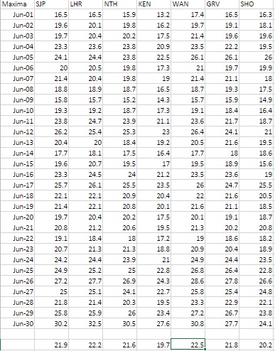
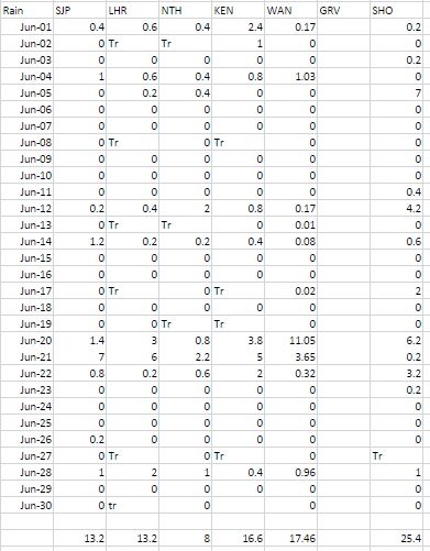
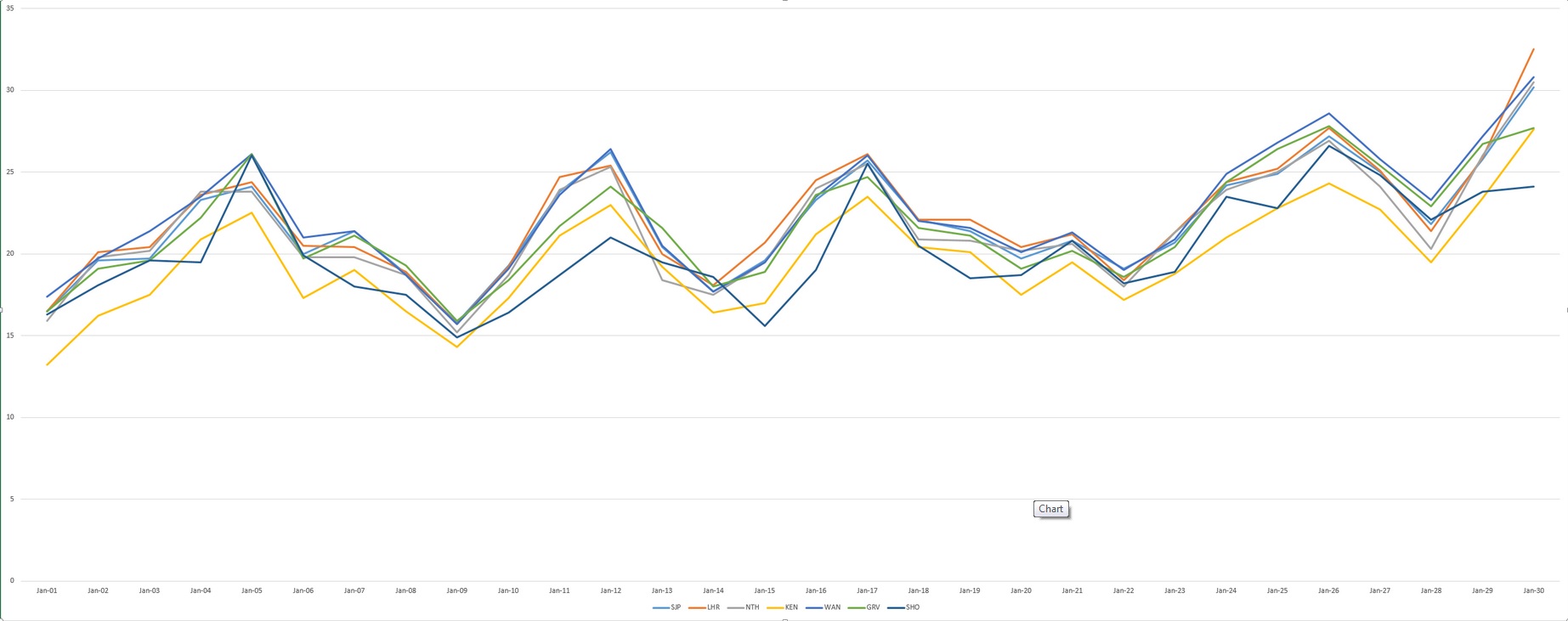
Maxima for stations near Wanstead SJP: St James’s Park, LHR: Heathrow, NTH: Northolt, KEN: Kenley, WAN: Wanstead, GRV: Gravesend, SHO: Shoeburyness
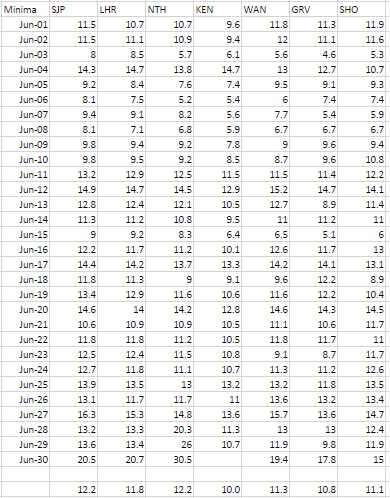
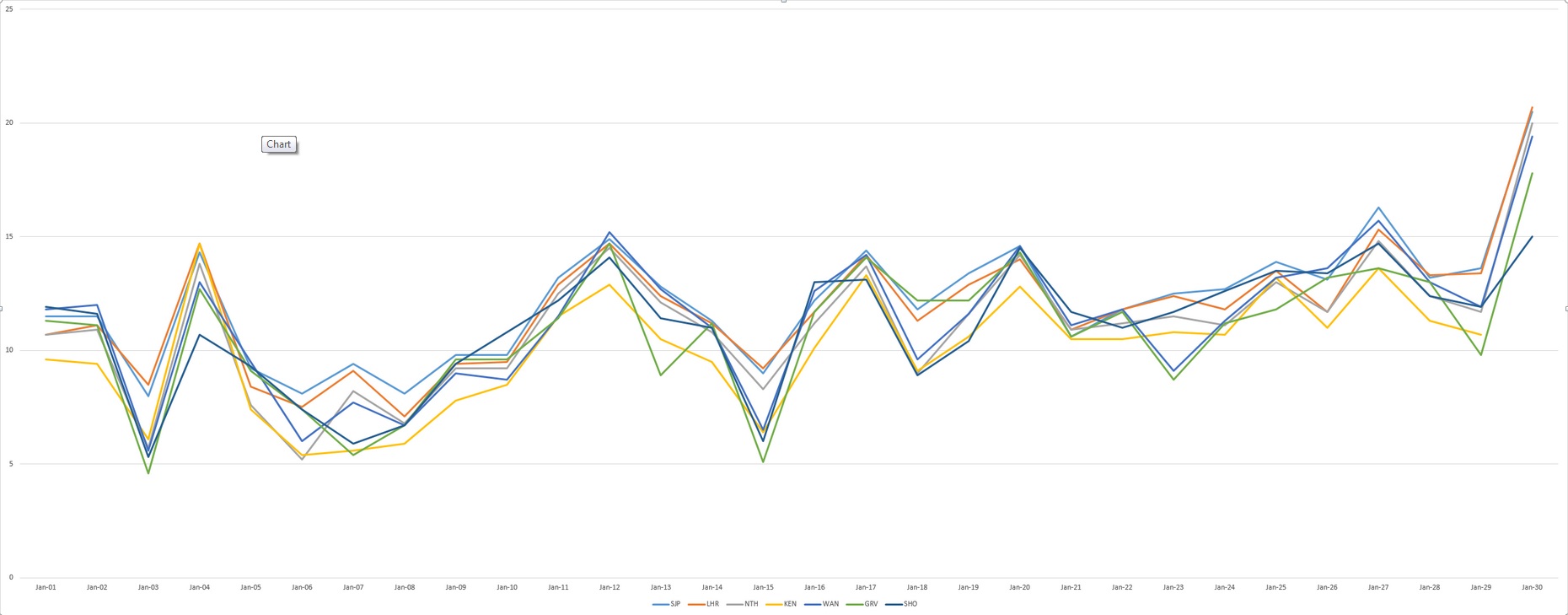
Minima for stations near Wanstead SJP: St James’s Park, LHR: Heathrow, NTH: Northolt, KEN: Kenley, WAN: Wanstead, GRV: Gravesend, SHO: Shoeburyness
To try to quantify this I’ve had a look at all the official stations around Greater London throughout June. The results show that readings from Wanstead are remarkably similar to other stations.
I first had a look at maxima which revealed that Wanstead is 0.3C warmer than Heathrow and 0.6C warmer than St James’s Park.
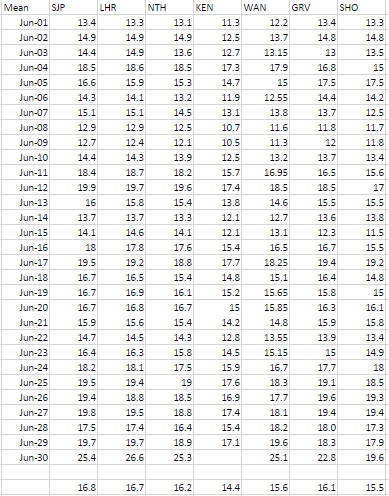
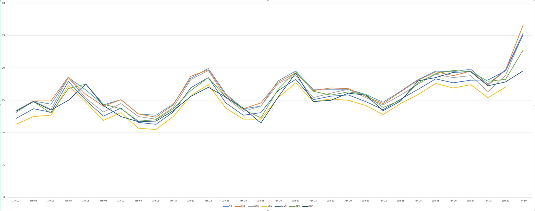
Mean for stations near Wanstead SJP: St James’s Park, LHR: Heathrow, NTH: Northolt, KEN: Kenley, WAN: Wanstead, GRV: Gravesend, SHO: Shoeburyness
Rainfall for stations near Wanstead SJP: St James’s Park, LHR: Heathrow, NTH: Northolt, KEN: Kenley, WAN: Wanstead, GRV: Gravesend, SHO: Shoeburyness
Minima, on the other hand, revealed that Wanstead was 0.5C cooler than Heathrow and 0.9C cooler than St James’s Park – a stark illustration of how much warmer inner London is than the suburbs.
This obviously had a bearing on the mean temperatures of the region, Wanstead being 1.1C cooler than Heathrow and 1.2C cooler than St James’s Park.
In terms of rainfall Wanstead was wettest, but only by 4mm.
So, all in all, the weather station at Wanstead is a pretty good measure of our local climate, as close as possible to what official conditions for measurement of climate demand.
I am currently in the process of trying to find a site local to the area that will fulfil Met Office conditions but it is a long, drawn-out process that will take time to organise.
Maxima for stations near Wanstead SJP: St James’s Park, LHR: Heathrow, NTH: Northolt, KEN: Kenley, WAN: Wanstead, GRV: Gravesend, SHO: Shoeburyness
Minima for stations near Wanstead SJP: St James’s Park, LHR: Heathrow, NTH: Northolt, KEN: Kenley, WAN: Wanstead, GRV: Gravesend, SHO: Shoeburyness
Mean for stations near Wanstead SJP: St James’s Park, LHR: Heathrow, NTH: Northolt, KEN: Kenley, WAN: Wanstead, GRV: Gravesend, SHO: Shoeburyness
Southwesterly winds have returned with a vengeance this week after being mostly absent for large parts of this year. The airmass to our west is pumping very mild and balmy air from a warmer than normal north Atlantic, bringing a mix of blustery winds and rain. It has also seen the return of the constant whine of planes on the flightpath into Heathrow, to enable the preferred method of landing into the wind.
Heathrow flightpath when the wind blows from the west
As they reach the Wanstead area the jets turn, approximately 6,000ft up, for their final approach into the UK’s only hub airport.
On a Monday the din begins with the overnight arrivals from the Far East. Today the 04:50 BA flight from Hong Kong, was delayed, giving residents under the flightpath a 10 minute reprieve until 5am when another BA flight, from Singapore, began its final approach. On a clear day 44 flights land every hour at Heathrow, or one plane every 1.36 minutes. And this figure is without the air traffic flying into and out of City.
.
The flightpath taken during an easterly wind diverts flights to the north and south of London
The congested flightpath during a westerly landing regime is in sharp comparison to an easterly landing regime – when the final turns occur over more rural areas. To give you some idea of what that looks like here is a time-lapse video of the jets landing
As noise goes Wanstead gets off lightly in comparison with places like Hounslow. Though the dB are vastly reduced over our part of town the noise is very noticeable on quiet streets first thing in the morning. A recent study suggested that there is a link between aircraft noise and increased risk of heart disease.
Heathrow and many business leaders want a third runway at Heathrow which is currently running to near capacity. They argue that without extra capacity the UK economy will greatly suffer. The owner of Heathrow argue that their case is the cheapest and quickest way to fix the UK’s capacity problem. Constructing a third runway is estimated to cost £18bn and would open between 2025 and 2029.
The London Mayor, Boris Johnson, on the other hand, wants a new hub to be built in the Thames estuary, at an estimated cost of £96bn. He is vehemently against expanding Heathrow, which exposes 250,000 west Londoners to extreme noise, and would like it closed.
The strength of Heathrow Airport Holdings’ case stems from how it is likely to be the cheapest and quickest way to fix Britain’s hub capacity crunch. Building a third runway could cost up to £18bn and would open between 2025 and 2029.
Contrast that with the estimated £96bn bill and 2029 opening target for a proposed new hub in the Thames estuary, although Boris Johnson, London’s mayor, says the net cost to the taxpayer would be £25bn once the new airport was privatised. Mr Johnson is a vociferous opponent of expanding Heathrow, which is Europe’s noisiest airport with almost 250,000 west London residents exposed to jet din. He wants it closed down.
Many commentators say his favoured solution of an estuary airport is pie in the sky – but with China keen to spend money on infrastructure in other countries you have to wonder ‘Why not!’. Hong Kong solved their own capacity problems at Kai Tak with the construction of an airport on reclaimed land at Chep Lap Kok off Lantau Island. The facility is designed by Lord Foster who has also designed a blueprint for the Thames estuary.
Not a week goes by without alternative plans to solve London’s capacity crunch being put forward – from Heathrow’s third runway to an option of second runways at Gatwick and Stansted. What many don’t seem to be talking about is the option of developing Manston in Kent.
As someone who has visited the area frequently over the past few years there seems to have been a disproportionate amount spent on infrastructure to what would normally pass for improvements to a region.
Roads around the airport have been dualled (not to alleviate any current traffic problems). Many Holiday Inn-type hotels seem to be springing up – always a sign that big money is about to move in. The HS1 fast train line has vastly speeded up travel times to the area – it wouldn’t cost much to extend a loop right in to what is now Kent International Airport / Manston). There’s also the redundant Pfizer site – which is linked to the airport via the new dual carriageway. Rumours around the fate of this site include a business park and new Hollywood studio.
The existing runway is one of the longest in Europe – it used to be on Nasa’s list of emergency landing sites for the Space Shuttle because of its huge length.
I think the airport is already host to a lot of air freight – judging by the number of 747 cargo planes you see landing. Other factors in Manston’s favour is the approach to the runway. Obviously it would be grim for anyone living in the coastal towns there in terms of noise – but it’s millions less than residential areas around Heathrow.
The area is also in dire need of job opportunities and is among the most deprived in the south-east.
Whatever is agreed it is a decision that is bound to be unpopular.


You must be logged in to post a comment.