Category Archives: Rainfall

Cloudburst at Brettenham, Suffolk

I hadn’t heard of Brettenham before this Suffolk village recorded over 100mm of rain from the convergence line event on the afternoon of Sunday, July 26th.

A former Environment Agency observer recorded 181.3mm in 1hr 40mins (1640-1820).

Notable on its own but even more so given that Wattisham, an official station 7.3km to the south-east, recorded just 2.4mm at the same time.

Whilst intensely isolated events happen, and often go unnoticed if they occur in uninhabited areas, this one seems more severe than what has previously been recorded.

The greatest 24hr rainfall recorded, according to Robin Stirling’s Weather of Britain, was 279mm on July 18th 1955 in Dorset. The rainfall far more widespread than the event on Sunday.

The event in Suffolk was covered by the East Anglian Daily Times. A report that mentions ‘rain falling in sheets and roads turned into rivers’ can be found here.

Advertisement

Four June washouts in london

Compiling a list of sunless, rainy days revealed some interesting spells of wet weather – the most miserable runs of June days in the capital since 1959.

First up was a three-day spell starting on June 25, 1974. Some 34.3mm of rain was recorded.

Next was a three-day spell starting on June 23, 1991. Some 26.3mm of rain was recorded.

Another three-day spell started on June 25, 1997. Some 36.2mm of rain was recorded.

Finally, and most recently, a two-day spell this month that began on June 17th. Some 28mm of rain was recorded.

The above spells all happened around the date of the ‘June monsoon’ singularity which has a probability of 77 per cent. Though the fact that these occurred 47 years, 30 years and 24 years ago shows that these extreme cases happen a lot less than three years in every four the singularity would suggest.

Comparing the current Northern Hemisphere pattern with 1974 suggests that while there’s just as much heat around at 850mb as there was 47 years ago, including an extreme heatwave over some Nordic countries, the air above Greenland appears colder.

Sunless days and washouts

The weather of late has been in stark contrast to the mostly dry, sunny (if a bit chilly) spring many enjoyed. Indeed the first half of June saw more of the same and, locally, was the warmest start to the first meteorological summer month since at least 1959.

My memory of summers years ago was that it was often hot and sunny but I also remember countless days of staring out the window for hours waiting for relentless rain to let up.

Looking back at sunshine stats to 1959 there has been over 4,400 days where no sun was recorded, roughly a one in five chance of a totally cloudy day.

Considering the months where the absence of sun is most noticed, May to October inclusive, the probability decreases to just under one in ten.

To decant these to ‘washout days’ I’ve only included those sunless days that were also ‘wet days’ where 1mm or more of rain was recorded. The probability further decreases to just under one in twenty.

All very interesting but were there more washout days decades ago or is the memory playing tricks?

Looking overall shows an increase since 2013. Out of all the months the most notable change has been August.

The coldest and wettest days of June

Looking out the window on a cold and miserable June afternoon yesterday reminded me of similar such days during the Seventies and Eighties.

But the mind plays tricks and I wondered if these kind of days were that common in the past.

To weed out the also-rans qualifying days had to be sunless with an anomaly that was at least 4C cooler than the daily average and rainfall of at least 12mm.

This gave the following list.

24hrd

So, in the last 60 years there have been only 12 days similar to June 10th 2019. That would give a probability of less than 1% (0.00743)

Looking elsewhere it would appear that there was much more rain to the north, south and west of Wanstead.

rain all


The curse of June 13th

1 Jun 21 Jun 16 Jun 77

June can be a strange month weatherwise. Scorching temperatures as well as washout, cold weather, perhaps epitomised by the Queen’s Diamond Jubilee pageant on the river Thames in 2012, can feature prominently.

The month can also throw up some striking anomalies, none more so than the fact that the 13th is the only day in the month where the temperature has never reached or exceeded 30C anywhere in the British Isles.

According to TORRO the highest daily maximum recorded in the UK is 28.3C at Earls Colne, Essex, in 1948; at Brixton, south London, in 1896 and Aboyne in 1994. Yet either side of this date has records comfortably above 31C, as the table below shows.

torro.PNG

The closest we’ve got locally to 30C in the last 60 years was in 1989 when 27C was recorded.

So why is the 13th ‘cursed’ with traditionally being the coolest day of the month? The best explaination perhaps is the fact that the date occurs more or less during the middle of the North-west European monsoon.

According to Philip Eden’s list of singularities the June monsoon can strike any time between the 1st and 21st but normally peaks on the 16th with a 77 per cent frequency.

As well as cool temperatures the phenomenon can also bring copious amounts of rain, as happened in 1903 when large parts of Redbridge were inundated following a 59-hour deluge that started on… the 13th.

Will we see a repeat this Thursday? Unlikely, though the general pattern is not that different to what led to events over a hundred years ago.

13th

October 2018: average and rather sunny

October was most notable for the amount of sunshine. Some 136 hours were recorded, that’s 127 per cent of average, the sunniest October for six years.

The mean temperature finished 11.6C, 0.2C below average, the same anomaly as September. And 1.6C cooler than October last year.

Some 52.1mm of rainfall was recorded, 78 per cent of the 1981-2010 average, the wettest October for four years.

To view full stats follow this link:http://1drv.ms/1kiTuzv

October 2018 max.JPG

London’s October extremes since 1959

October is one of those months that can see both ends of the spectrum; from calm ‘mists and mellow fruitfulness’ and, rarely, frost, to wet and wild systems whistling in off the Atlantic, best known being the 1987 Great Storm and, more recently, the St Jude storm.

I’ve put together a few top 10s of stats for Wanstead, St James’s Park and Heathrow for the month of October.

october extremes

October SJP

Heathrow oct

Some national UK October values according to TORRO

Hottest: 29.4C March, Cambs – 1st 1985
Coldest: -11C Dalwhinnie 28th 1948
Wettest: 208.3mm Loch Avoich 11th 1916

In terms of climatology October maxima, considering the 1981-2010 average, shows a decline through the month, though around the 8th and 20th there is often a spike. This would reflect the October singularities; early October storms, between 5th and 12th, peaking on the 9th, occur in 67 per cent of years. St Luke’s summer, between 16th and 20th, peaking on 19th, also has a 67 per cent probability.
Mid-autumn storms occur between 24th and 29th October, with a 100% probability.

october average graph

The average rainfall graphic shows that downpour amounts are variable through the month. A tendency for dry weather around the 17th and 18th before the wettest days on the 20th and 21st.

October rainfall


The disappearing deluges of September

While putting together my September extremes blog I noticed that the month was marked by some big rainfall episodes. On a national scale TORRO statistics show that a south-east climate station holds the daily record for September – unusual in that every other month is dominated by stations in the north and west of Britain.

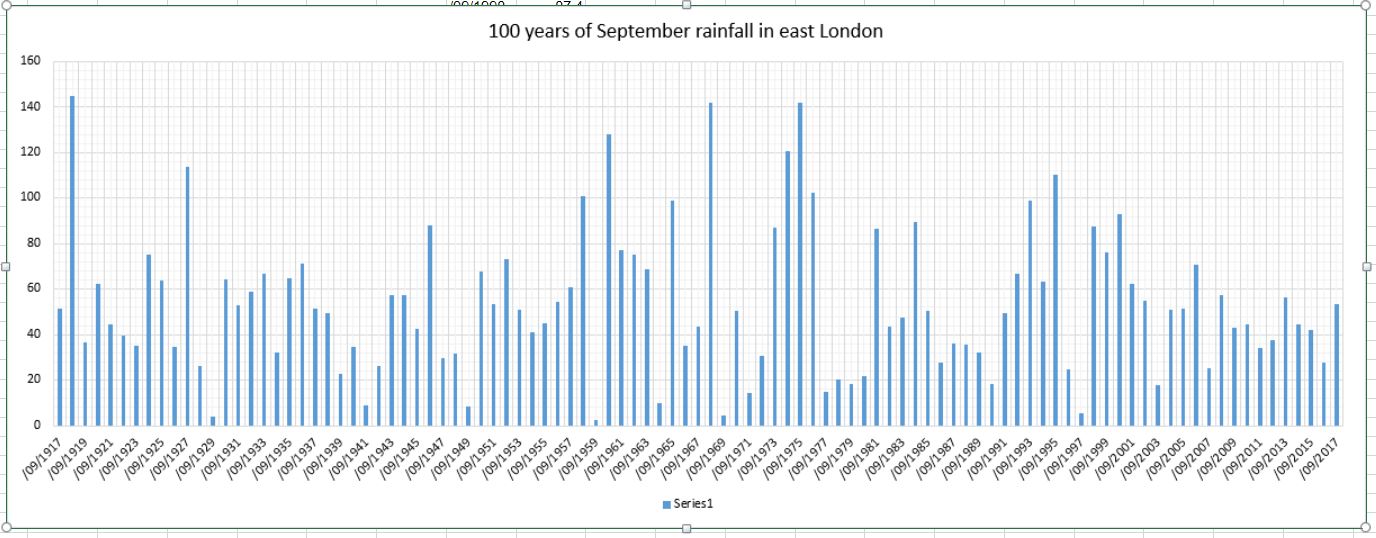
Further analysis of local data since 1959 shows how September has slowly evolved from being dominated by autumnal to summery weather. The wettest period, from the mid Sixties to the mid Seventies, saw 42 per cent of highest daily rainfall events recorded.

Two of these events, in 1968 and 1973, are well noted and appear in RMET’s Weather magazine.

1968

In Wanstead, between 14th and 15th September, a total of 58.4mm fell, a large total though far less than elsewhere.

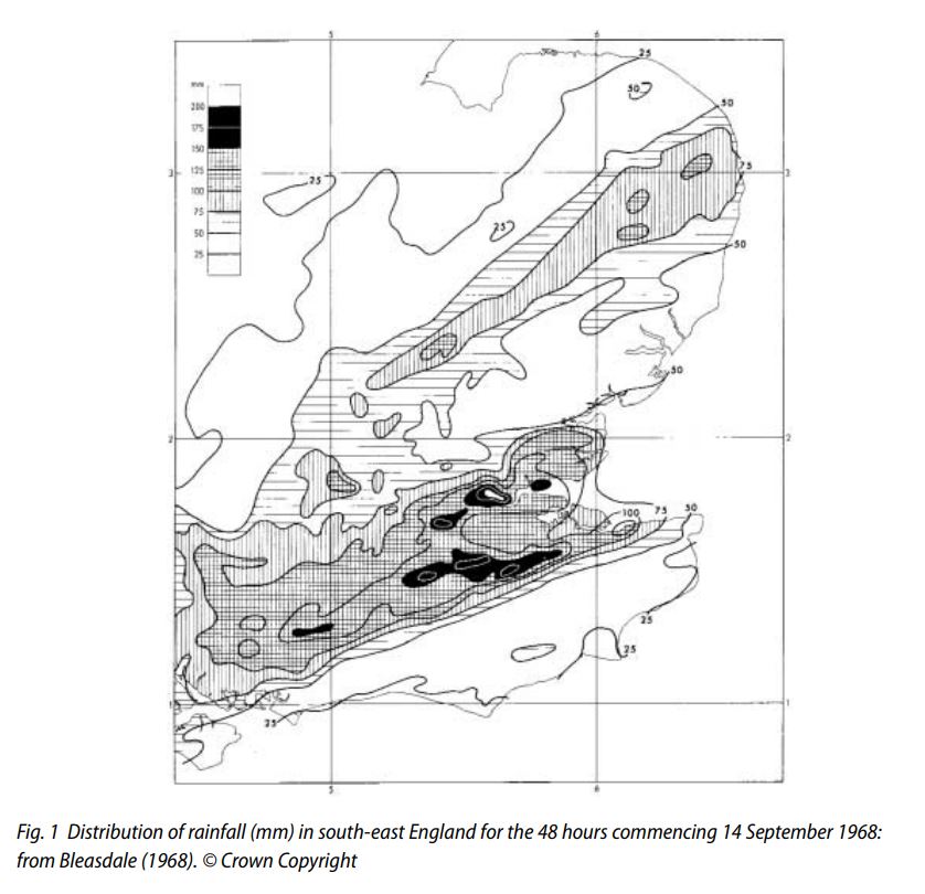
The rain became torrential overnight in southeast England and continued through most of the 15th. Rainfall totals ranged from three inches in the London area and nearly four inches in southern Essex to approach the quite abnormal level of nearly seven and a half inches in parts of Kent during the 14th/15th.

The area of greatest precipitation was near the Kent, Surrey and Sussex border where violent downpours in the 12 to 15 hour period from midnight on Saturday to the early afternoon of Sunday 15th led to widespread and disastrous flooding. The heavier rain area moved north and east during the night of 15th/16th and Gorleston recorded.

The highest accepted two-day falls were 201mm at two rain gauges at Tilbury
and Stifford in Essex, and a similar fall north of Petworth in Sussex. The highest ‘rainday’
totals (i.e. nominally 0900–0900 GMT) listed in British Rainfall 1968 were 129 mm at
Bromley and 125 mm at South Godstone sewage works in Kent, both on 15
September.

This exceptional event was described by Bleasdale (1974), Salter and
Richards (1974) and Jackson (1977) and the map below (Fig. 1) is taken from Bleasdale’s
paper in British Rainfall 1968 (p. 231). In all, some 575 km2 received more than 150 mm
in 48 hours.

1968 rainfall

1973

In Wanstead, on 20th, a total of 55.4mm fell, the largest daily total recorded in September. Again it was far less than elsewhere.

5pm gmt 20th 1973

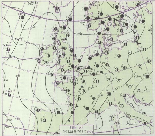
There were notable falls of rain in London, Surrey, West and East Sussex, and particularly Kent. At Manston, near Margate, 172 mm fell in 18 hours 40 minutes commencing 1710 GMT; at nearby West Stourmouth 190.7 mm fell in the rainfall day i.e. the 24 hours commencing 0900 GMT on 20 September (source: Met Office internal list of heavy falls of rainfall in short periods in the United Kingdom during the year 1973; Rainfall/heavy falls section listing, available in manuscript/computer printout form in Met Office archives).

The future

Big September rainfall events seem to be becoming rarer in our part of the UK, the last was in 2014, on the day of the Scottish referendum, though this was convective rather than frontal rainfall.

The outlook for the rest of this month suggests yet another absence of a large rainfall event. The ingredients for large rainfall totals in the south-east – blocking high to the north with slow moving low pressure over Brittany – look unlikely to form during the remainder of the month. We probably will see rain but any fronts are likely to move through quickly, with typical totals being around 5mm.

rain rest.gif

When did September become a summer month?

The answer is around 1993. A look back at mean temperature and rainfall statistics for east London over the past hundred years reveals that the ninth month has, since that date, slowly become warmer and drier.

Putting all the arguments of meteorological and astronomical summer aside, many people of a certain age regard September as an autumnal month, but as recent years have shown it can very often be an extension of summer; September 2016 was the second warmest on record in the local area, warmer than many previous summer months!

Looking back even further, over the past 100 years, the September mean has trended upward, though many peaks and troughs reveal how the month has ebbed and flowed from being summery to autumnal.

The prognosis to the end of this month suggests that air pressure will be anomalously high – so the pattern in the south-east for settled, summery weather in September doesn’t look like ending any time soon.

sept means
The September mean trend has crept generally upward.

sept rainfall
A look at rainfall back over the last 100 years shows that wet Septembers have been on a general decline since 1994.

sept chart.gif

Birth and death of a thunderstorm: May 28th 2018

After the previous two days’ thunderstorm events it would be easy for this one to get lost in the ether. However, being super local and how quickly it developed and then died was enough to pique my interest.

After a very warm and humid afternoon where the temperature peaked at 26.2C clouds began gathering to the east with the first rumbles of thunder at 6.45pm. The huge cumulonimbus could be seen from Southend.

anvil21927

And Simon Cardy took an excellent shot from the other end of the Thames.

cardy1925


davwe

By 8.17pm the storm that had moved west had decayed markedly.

sunset

The 24hr rain totals at 09 on May 29th show how local the storm was. St James’s Park, 9 miles to the south-east, recorded half Wanstead’s total.

sjp

Timeline (BST)
1840 first peals of thunder heard
1847 first drops of rain
1856 downpour
1857 cloudburst
1901 16mm/hr 1.7mm
1903 very heavy
1909 burst of >5mm hail recorded. Rain rate 60.4mm/hr
1929 rain ceased (10.4mm in total)

nm9FIt


This slideshow requires JavaScript.