Today, 75 years ago, saw the heaviest casualties of the Blitz in South Woodford – a parachute mine in the Stanley Road area killed 17 people and injured dozens more.
George Lane, South Woodford, during the Blitz
The day, a Monday, dawned bright and sunny and revealed yet more destruction from the previous night’s raid as shopkeepers in George Lane cleared away shattered glass caused by a high explosive bomb.
Some 10 hours of sunshine lifted the temperature to above 18C, conditions brought thanks to high pressure building in from the west. But the fair weather was in complete contrast to what lay in store as night fell.
At 9.19pm two high explosive bombs fell on 62 and 74 Gordon Road, South Woodford, demolishing four houses. Over the next 15 minutes three similar missiles fell in Broad Walk, Cheyne Avenue and Chelmsford Road, leaving people trapped and bursting a water main.
However, a couple of minutes later, a parachute mine landed on Stanley and Chelmsford Roads, killing 17 and injuring dozens. Some 36 people needed hospital treatment. Further bombs damaged a nursing home in Grove Hill.
The air raid brought the highest number of fatalities in any single incident of the Blitz in Wanstead and Woodford. The extent of the damage to property was considered the first affair of real magnitude that the local Civil Defence services had faced.
* The first paramine fell early on the morning of September 21st. A plane carried two mines, one under each wing, and released them simultaneously. Controlled by its parachute, 20 feet in diameter, the mine, containing an explosive charge of one tonne, drifted slowly down. If the first explosion was not followed quickly by another, it was fairly certain that not too far away was an unexploded mine. Discovery, as of all unexploded bombs, was the job of the warden who was working in the blackout.
** The area of damage cased by the blast effect of the paramine could extend 650 yards from the landing point
Thunderstorms and prolonged heavy rain aren’t what you usually associate with the Aegean in August. So to experience three days in a row of inclement weather must be rare in this beautiful part of Europe.
Water from the hills above turned local roads into rivers
Arriving at the end of a heatwave the owner of my hotel in Skiathos remarked that humidity had been particularly high though temperatures had cooled from the previous week’s level of 36C – not bad in itself but when you consider the low fell to just 27.1C those sorts of values make it impossible to sleep without air conditioning.
Sunshine on the first couple of days came to an abrupt end on the Friday night with the arrival of the first disturbance – the sound of thunder and torrential rain audible above the low buzz of the air conditioning. The storm gradually cleared in the morning to leave sunny spells by the afternoon.
This process repeated itself over the next couple of days although by the third night only heavy rain developed. Since returning to the UK I’ve had a look at statistics from a weather station located on the north of the island near Kastro. Rain totals on August 21st, 22nd and 23rd were 36.2mm, 39.2mm and 34mm respectively – bringing the total for the month to 113mm, nearly three times what fell last August. Looking at national Greek totals on Ogimet the disturbance was very localised.
Torrents of water from the storms caused deep scars in the landscape. I spotted this at the edge of an olive grove during a walk through a forest to Mandraki
The torrents of rain carved deep gorges in the paths that criss-cross the island. And during a walk from Koukounaries to Madraki part of the impacted sand/soil road down to the beach had been washed away.
Locals didn’t seem that phased by it and judging by the number of tavernas with wind down sides to their awnings it is perhaps a common feature of the climate?
Mean temperature for August was 0.3C up on last year: 27C, though the number of days of >32C was nearly half last year.
The island, part of the Sporades, is famous for being the location where the hit musical Mamma Mia was filmed – though most filming was done on neighbouring Skopelos. It’s a very green area – much more so than southern islands I’ve visited such as Ios and Crete which are arid by comparison.
During a visit to Skopelos, which has a landscape that looks almost Alpine from a distance with its pine forested hills, I was puzzled by the lack of wind turbines, especially considering how reliable wind seems to be in the surrounding waters.
One of the many stunning beaches on Skiathos. This bay is close to Mandraki
Greece does have an extensive wind power programme though much of it is based in the mountains in the north. EU politics over energy tariffs also probably play a part.
Thunderstorms also played a part on our flight home. As we crossed the mountains of Macedonia and the Balkans to the north I could see vast cumulonimbus begin to form. The pilot made an excellent job of keeping turbulence to a minimum by steering us around these forces of nature – a couple of which reached above our cruising altitude of 39,000ft.
* Storms also affected Skiathos and Skopelos in September. A weather station on Skopelos reported 209.6 mm on 22nd September, with an additional 56.2mm on the day before and 49.2mm the day after. The month there has abundantly given 317mm, but this is *not* the wettest area of Greece for September so far. The very warm seas at this time of the year have given numerous places a lot of precipitation, backed up, of course, by great support aloft .
The storm caused much damaged and devastation to infrastructure in the towns in Skopelos.
The island of Skopelos is even more stunning than SkiathosMuch convective development could be seen during the flight home as we crossed Macedonia and the Balkan mountains to the northThe pilot made a good job of steering round the storms. It made a change to see these marvels of nature from above – though some still developed higher than our 39,000ft cruising altitudeIn a shop close to Koukounaries beach I noticed this selection of snowy pictures that were taken on the island a few years ago. Being north of Athens it is not surprising that they occasionally see snow here
Summer 2015 has got quite a bad press over the past couple of weeks but it hasn’t really been that bad overall in this area. And, as ever with the weather, it wasn’t without interest.
Though the summer was wet overall it was very dry well into July
Two extreme records were broken: The maximum on the 1st of July of 36.1C and the minimum on the 30th of July of 6.9C. There were also a couple of cracking thunderstorms.
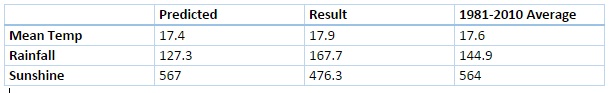
Mean temperature for the three months was the lowest since 2012, the same year that saw more rain than this summer’s 167.7mm. Both 2012 and 2011 were a fair bit wetter than this summer and this season’s rainfall wasn’t a patch on some of the washout summers of my youth – both 1985 and 1987 were at least 150% wetter than summer 2015.
More notable was the lack of sunshine – it was the dullest summer since 2002.
Looking beyond Wanstead the perceived poor summer elsewhere was largely caused by cooler than normal sea temperatures west of Ireland, together with warmer water around the Azores. Simon Keeling explains this well here.
Three months ago I predicted that summer would be broadly average temperature-wise with average to slightly below average rainfall and average sunshine. So how did the forecast do?
In terms of temperature my predicted figure of 17.4C was 0.5C lower than the result. My rainfall prediction was only 76% of what actually fell and I over-estimated sunshine by 16%.
Despite some of the dire reviews of summer elsewhere in the UK there were some fine spells
This August was the third dullest since 1881. I’ve seen mentioned recently that August used to be regarded as an autumn month. For the past couple of years the final ‘summer’ month has been very disappointing for anyone looking for fine weather – much more akin to September or even October.
A storm in south London gave this eerie light seen at Southwark Bridge on the 5th
The first third of the month began pleasantly enough with a couple of days exceeding 27C. And on the 22nd the temperature reached 31.4C, only the third occasion that the mercury has risen above the 30C mark this summer. But summery highlights were few and far between.
Just under 120 hours of sunshine were recorded – that’s 62 per cent of the monthly average, the dullest August since 1968.
There were six occasions when the maximum exceeded 25C. Mean temperature for the month was 18.2C, which is on the nose of the 1981-2010 mean. Rainfall of 79.8mm was 159% of average. The wettest day occurred on the 24th with 18.4mm of rain.
What has September got in store weatherwise? The models today (September 1st) suggest a very slow progression of high pressure ridging into the UK from the west this weekend. Until then a cool northerly flow will persist with a mix of sunshine and possibly heavy showers. Most models suggest that by the end of the week a trough will run south, bringing a spell of cloud and rain before high pressure from the west eventually cuts off the cool northerly, replacing it with little or no wind, warmer sunny spells by day and misty nights – typical late summer / early autumn weather. Models then split over what will happen with the high next week. It could stay settled or, according to the ECMWF and GFS, the start of a breakdown could happen at the end of next week.
The synoptic chart shows the frontal set up that brought the greatest daily rainfall on the 24th
My long range outlook method suggests that September will be average temperature-wise, a mean of about 15.4C, at 52% probability. The next highest probabilities are for something rather warm and warm, both at 14% probability, though something rather cool also comes out 14% probability.
The highest probability for rainfall is 45% for something average. The next highest probability is for a dry September, at 23%. Rather wet works out at 14%.
My data for sunshine only stretches back to 1878. There is a 60% chance of average sunshine in September.
My August outlook was OK – I went for an average to rather cool August. I also said there was a 73% chance of a duller than average August – so not bad overall.
Here follows the full weather diary for August…Full stats for the month here:http://1drv.ms/1rSfT7Y
1st Bright but hazy start. Cloud gradually thinned to give a sunny afternoon with just a few clouds. Warmer.
2nd Sunny start with decreasing cloud.
3rd Sunny start quickly turned cloudy and blustery with brief burst of rain at 4pm. Then dry with variable cloud overnight and breezy.
4th Bright start but lots of cloud around and breezy. This lasting through the day.
5th Cloudy start, a few bright intervals and a strange light as thunder clouds passed to the south. Some light rain.
6th Cloudy start but cloud thinned to become sunny just before 2pm. Then variable cloud through the day with another eerie sunset.
Many places around the coast recorded far more sunshine than Wanstead, typical of the type of weather experienced in August
7th Sunny start though was very cloudy at times.
8th Bright start and cloud quickly melted away to leave a stunning, sunny day in Sussex and Camber. Some cloud was seen a few miles inland but even this eventually melted away. Night turned chilly with heavy dew by dawn.
9th Sunny until 3pm then a bank of cloud brought cloudier spells. Warm overnight.
10th Bright start with sunny intervals. A burst of rain at 2pm damped the ground then it was mostly cloudy for the rest of the day.
11th Cloudy, calm start, spits and spots of rain before more organised rain in evening.
12th Cloudy start then brief sunny spells late morning before clouding up again. Warm front stalled over South Coast dumping 32mm on Herstmonceux.
13th Cloudy with rain spreading in late morning, this lasting until 3pm with odd burst of drizzle for rest of night. Some 78mm in Polegate and flooding reported in Brighton.
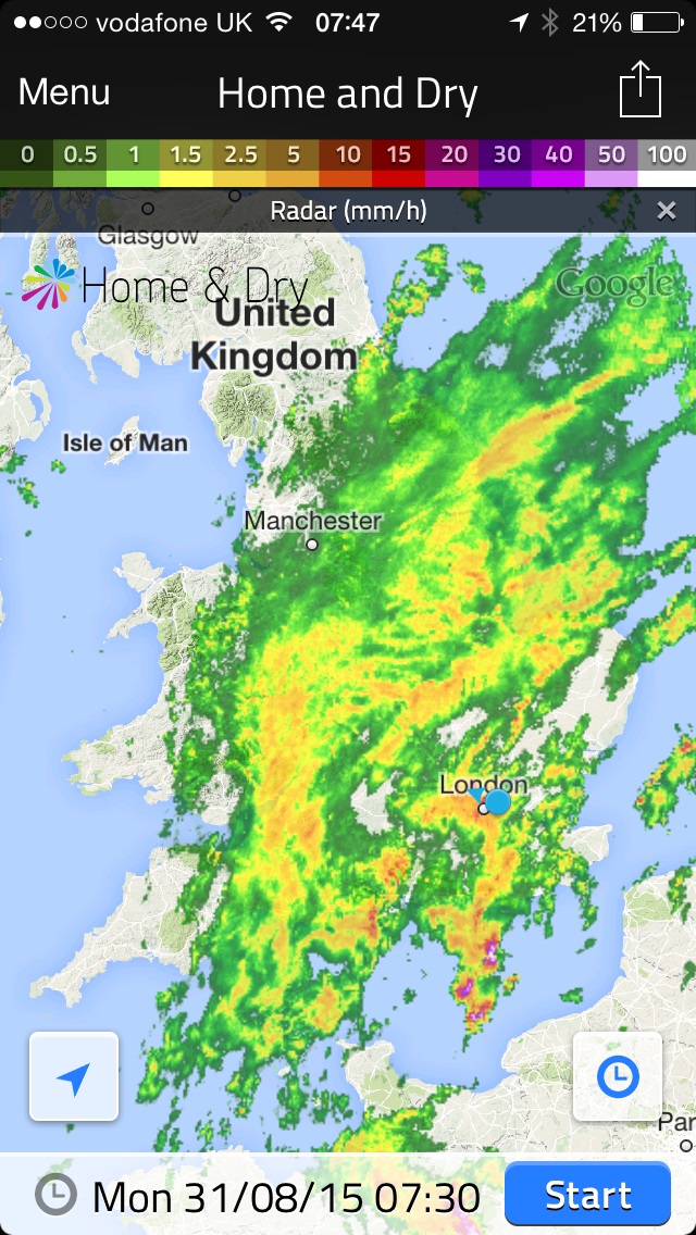
14th Cloudy and very humid with some brightness late morning. Showers returned at 3.30pm then more general rain arrived at 8pm.
This radar shows the area of rain that brought over 10mm to Wanstead on 31st
15th Sunny start, clouded over at 2.30pm but then became sunny again at 5.30pm. Clear spells overnight.
16th Sunny start then cloudier in the afternoon. Very still air though made it feel pleasant.
17th Sunny start then cloudier around lunchtime. Sunny spells late afternoon though sun didn’t feel that strong.
18th Sunny start though quickly clouding over and dull. Some spots of rain on way to airport but dry in Wanstead.
19th Sunny start then going downhill with rain in the evening and overnight.
20th Bright start, clouding over.
21st Bright start before breaking to sunny spells and warm.
22nd Long sunny periods and 3rd occasion of 30C.
23rd Bright start but cloud built to give rain between 12.45 and 2.45pm.
24th Dull, rainy with rain between 9am and 11am.
25th Rain between 1pm and 3pm. Showers overnight then more general rain at obs time.
26th Dull and rain morning with squall blowing through at 1.30pm. Brightening up by 5pm then some bright spells late afternoon.
27th Bright start but with heavy cloud present. A brief shower in the afternoon before a clear evening made it chilly overnight.
28th Sunny start with light breeze, tending to cloud over middle part of the day. Skies cleared again to give sunny, pleasant evening.
29th Sunny start, cloud filled in by 3pm then rain arrived at 4pm, with moderate bursts.
30th Cloudy and humid start. Cloud stuck around all day – airless and therefore felt pleasant.
31st Cloudy start after overnight rain. The rain soon returned after 10.20am and fell, often heavily through until 12.30pm.


You must be logged in to post a comment.