The Met Office Library holds millions of daily rainfall observations in its archives. Though anyone can access these physical treasures in person, and on request by email, a lot of these records taken before 1960 remain hidden away.
Yet these data provide an excellent insight into the behaviour of our weather on a local scale. As good as computer models are they are still a distance away from being able to forecast thunderstorms and frontal rain at smaller resolutions. Data from the literally hundreds of smaller rainfall stations set up in Victorian times would provide local government agencies the ability to identify where rainfall is historically heaviest and therefore areas where flash flooding is a greater risk.
For a number of years some of the archives have been digitised with the help of citizen science campaigns; the records of the Ben Nevis Summit Observatory being one historic station now digitised.
Though AI has improved computers still struggle with handwritten records; the best method is still to scan them all by hand before an army of volunteers get to input them onto online spreadsheets.
The cost to scan the rainfall archive pre-1960 would be £100,000. Though this sounds a lot for a ‘nice to have’ digital archive it could save millions in the cost of reactionary local authority work thanks to measures taken to plan against problems with flash flooding before they appear.
Snow is ever present in the UK in most years though you have to look hard to find it in high summer.
A dedicated group of enthusiasts, led by Iain Cameron, chart and catalogue these snow patches – many of which are hidden or only seen as distant white dots during Scottish Highland walks.
Responding to an appeal in September I met up with Iain and other volunteers to chart the patches in Observatory Gully on Ben Nevis, the UK’s tallest mountain.
Our route up in the shadow of the magnificent north face of the Ben was a warm one; to our left a procession of ant-like figures were tracking the CMD arrete route to the summit, walkers making the most of the amazing weather.
The North Face path up to the Ben was easy to follow under clear blue skies. My previous visits to the fogged-in summit required map and compass.
Out of the sunshine it was noticeably colder in Observatory Gully; being north facing it sees very little of the sun even in mid June, slowing down the rate of melt of the snow which can be tens of feet thick by the end of the snowfall season. Being encased in snow for so long obviously has a chilling effect on the rock.
The walk up on the scree was hard work and I was surprised to see so many debris including parts of large parts of old galvanised chimney cowls, the legacy of the observatory that once sat proudly on top of the Ben. Not many people trek this way, being a bit of a cul-de-sac. To reach the 1,345m summit from here requires a 200m climb at the end.
As we edged higher the dot of snow grew ever larger and is surprisingly big by the time we reached it, Iain was surprised how hard the snow was. From Iain’s reports, published in the Royal Meteorological Society’s Weather magazine, I’d been fascinated by the images of the patches with naturally carved tunnels underneath them; the light inside the ‘cave’ has a gorgeous blue hue to it.
The light inside the snow patch has a gorgeous blue hue to it. It is understandable why so many are drawn to these ‘cathedrals of snow’.
It was at this moment that I realised that this was a large part of the draw of tracking these patches; a fascination with snow in an area where the odds of it existing all year round seem to be forever diminishing.
At the start of Observatory Gully the snow patch is a tiny dot.On closer inspection the snow patch is a few dozen feet across and is far bigger than it looks from the valley.
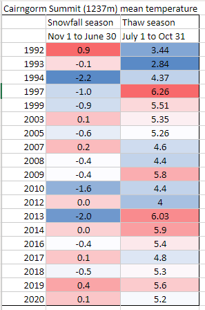
Seasons of melt and snowfall
Snow has only vanished entirely in Scotland six times. Three of these occasions were in 2003, 2006 and 2017.
Mean temperature statistics from Cairngorm Summit show just how much the seasons can vary. Of course mean temperature is just one variable that affects snow survival rates. For example the Western Highlands saw huge amounts of snow fall in February and March above 300m, a factor that would have helped snow survive. Though the most recent melt season was 0.4C cooler than 2019 there was probably a far greater volume of snow.
* Because of the unreliable nature of mountain-top records the Met Office data for Cairngorm Summit has some large gaps, it is only the last 5 years that have complete records . I discounted any years that were missing more than 5% of data.
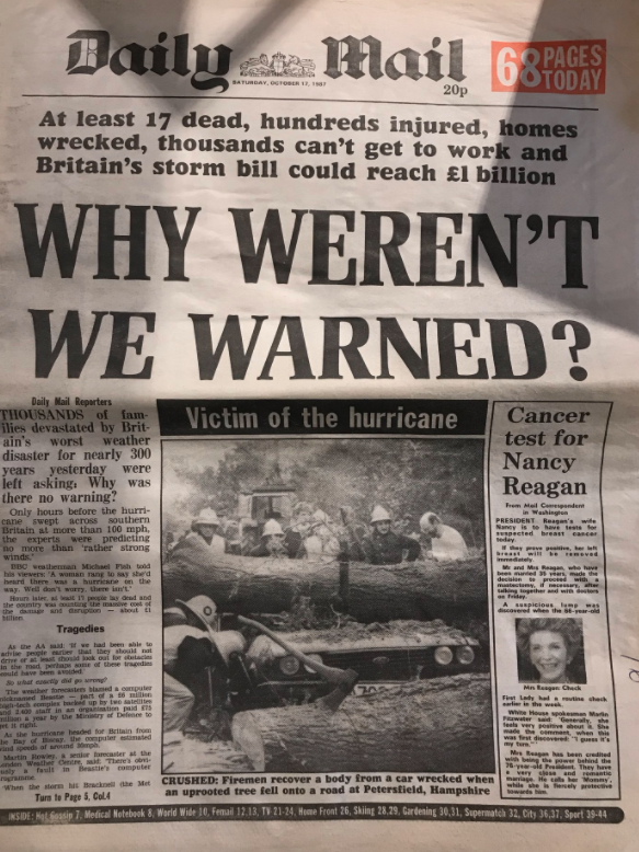
This month marks the 30th anniversary of the Great Storm. Some 18 people were killed as winds gusting to nearly 100mph affected London and the South East. Around 15 million trees were lost with Sevenoaks in Kent losing six of its seven historic trees.
Courtesy of the Met Office
The rapid development of ‘Low M’ took forecasters by surprise, the favoured outcome was for the low to move up through Brittany, remaining in or to the south of the English Channel.
I was living in a fairly sheltered corner of the London borough of Havering in 1987. I remember heavy rain just before midnight, around three hours before the storm reached its height, was heavy enough to send water trickling into my room, thanks to an overflowing roof valley. I thought it strange that Michael Fish hadn’t mentioned its severity in his lunchtime forecast.
I was awoken around 3.30am by a loud crash. Looking out the window I saw two dustbins flying down the road. You could sense each gust building in strength – the next dislodged a roof tile, sending it crashing on to the family car. By this point my mum and sister had awoken, my sister swearing she could feel the whole house moving: Mum ordered us downstairs. By this point the power had gone off and we sat listening to a small battery-operated transistor radio. We listened to updates from BBC Radio London where, like most other people, nobody knew what the hell was going on. The storm continued and first light gradually revealed the damage in the garden – a couple of trees over and next-door’s shed on its side; nothing compared to the rest of the region. But the disruption meant I didn’t attend school that day.
The storm was obviously a weather nut’s dream, and following so close on the heels of the coldest January I can remember. John Hall, of Surrey, can remember the storm well: “I’m not normally a very heavy sleeper, but I somehow managed to sleep through the worst of it (in Cranleigh, then as now).
“It was still windy when I woke around 7 am, but presumably not nearly as much as it had been earlier. By some miracle we still had mains power, and it was only when I switched on the radio and there was no sign of Radio 4 that I realised that something was up. (I assume the transmitter must have been damaged.) I walked the half-mile to the centre of the village to get my morning paper and then to catch the bus to Guildford station for my journey to work.
“It was only then that I learnt from the newsagent that there were no papers and wouldn’t be any buses, as every road in and out of the village was blocked by fallen trees. So I went home, switched on the TV and learnt all about what had happened.”
Dave Cornwell, of Laindon, south Essex, said: “Quite exciting but scary for me at home in Laindon. I awoke probably around 3.00 am to the sound of a metal dustbin lid (remember those?) flying down the street.
“Things sounded pretty bad and my sixth sense told me this was no ordinary windy night. I got up and looked outside and there was stuff flying by and lots of strange noises. One was my plastic gutter blown down and banging against the side of the house. I can’t be certain of the timings but we awakened our two young daughters and took them downstairs as I was worried as they slept in a room with a flat roof dormer window and there was a tall brick chimney stack directly above it. I heard more crashing sounds which unfortunately turned out to be a couple of roof tiles landing on my car roof which was parked in the drive. Of course with no internet then I did what a lot of people did and tuned into the police FM radio network. This gave me a better realisation that it was serious as they were describing the carnage on the roads and all of the emergency calls they and the fire brigade were getting.
“At about 5.30am I ventured out into my driveway to see if there was any serious damage but the storm was still raging and I can honestly say I couldn’t stand up and was unable to keep my balance so went back indoors. I think the wind speed was probably over 100mph at this point being funneled down the side of the house which runs south-north.
“By 8.00 o’clock I was getting ready for work and although by then people were being advised to stay at home I worked in a fairly essential service so thought I would give it a try. I managed to get to East London but there was debris everywhere and I saw a car completely crushed by a one of many trees that were blocking some side roads.
“Another thing I noticed that evening was my south facing windows had a layer of salt on them which must have been blown in from the south coast 60 miles away. It was a sight I’ll never forget and to this day I don’t like strong winds (had a scary flight at Heathrow in a severe gale as well) and always get a nervous feeling if I hear the wind getting up. Probably the most dangerous weather I have experienced anywhere in my lifetime.”
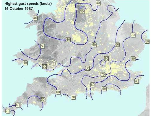
Much has been written about the storm, a ‘once in 500 year event’, including this summary by the Met Office. There is also an excellent paper by Bob Prichard published in Weather. The synoptic charts below show how Low M develops from 1200 on the 15th to 1800 on the 16th.
15OCT87 1200
15OCT87 1800
15OCT87 2400
16OCT87 0600
16OCT87 1200
16OCT87 1800
Because of widespread power cuts many television viewers didn’t see this recording of ITV’s Good Morning Britain at the time of transmission. A round up of the immediate aftermath of the storm, including comments from Jack Scott, can be seen in this edition of Thames News.
The following Daily Weather Report was published by the London Weather Centre:
An intense, and almost certainly exceptional, depression crossed the coast of south Devon soon after midnight, moving quickly, and deepening rapidly, with a track across the Midlands and out towards the Humber Estuary, leaving the United Kingdom land area around 0700 hours.
Some very severe conditions due to storm force winds were generated around the southern and eastern flank of the low, with gusts from approximately 0200 hours well in excess of 70 knots, and reaching a peak in the period 0300 hours to 0700 hours, with gusts to 90 knots reported from Herstmonceux and St Catherine’s Point in the early hours, and similar value gusts from the Channel Islands. The very stormy conditions were accompanied by some heavy rain, this rain pushing into Scotland and parts of Northern Ireland after dawn.
Clearer weather, on westerly winds, swept across southern Britain, pushing the worst of the stormy winds away into the North Sea. During the afternoon the country settled down to a blustery westerly with some heavy and thundery showers developing in clusters, running especially into western and southern coastal regions and parts of southeast England.
Across Scotland and northern England the skies remained cloudy, with outbreaks of mostly light rain, but troughs enhanced the showers in the northwest later in the evening with heavy rain. It was a rather cold day in most places, although the temperatures were near normal in the southeast.
The storm remains the most severe I have experienced in this part of the UK. The Burns’ Day storm in 1990 brought severe gale force winds in the London area but the low pressure was centred much further north.
The most recent severe windstorm in the London area, the St Jude Day storm of 2013, brought strong winds but nothing on a par with 1987.
15OCT87 2400
25JAN90 1200
28OCT13 0000
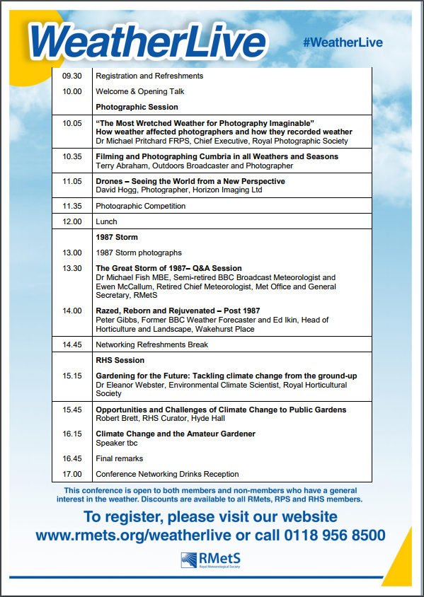
The anniversary of the storm, complete with a question and answer session attended by Michael Fish, will be marked at the Royal Met Society’s WeatherLive event in November.
Signals for winter have always been well reported by the media. Back in the 1980s weather anoraks across Britain would wait with bated breath to read Bill Foggitt‘s latest prognostications for the coming winter. Though Foggitt had some success his observations, among other weather ‘gurus’, often amounted to weatherlore that has only a slightly greater than evens chance of being right.
One popular myth is that very large blackberries mean a harsh winter. The fact that this has more to do with plentiful rainfall plumping up the fruit at harvest time is ignored.
Colin Finch’s 38F minus rule is altogether different and provides a very good guide to the kind of weather we can expect in January and February. For the rule to work the maximum temperature must be 38F (3.3C) or less for four consecutive days before Christmas Day.
Colin, an amateur meteorologist who passed away in 1991, spent much time researching his rule in the 1970s. He found that most of the coldest winters since the end of the second world war gave a hint of things to come in the weeks leading up to Christmas: the Decembers of 1946, 1955, 1962, 1968, 1969, 1978 were all followed by cold late winters. In 1984 and 1985 the cold spell arrived at Christmas. Other years to loosely follow the rule, 1986, and 1990.
A few weeks ago I was reminded about Colin’s findings and decided to have another look, using daily record data for this area stretching back to 1806.
The results were surprising. If there is a run of cold days (3.3C or less) around mid-month the chance of an average to colder than average January and February is 94% and 74% respectively. The chance of an average to colder than average March is 96%. Also notable is that the chance of a severe spell in January (4C colder than normal) is 30%.
So much for the figures. What are the chances of a run of cold days between now and Christmas Day?
Sunset Southwark Bridge
Up until this week the weather has been fairly quiet with little rain and cold, often frosty nights. But westerlies are now roaring back in from the Atlantic and could be a hint of what is likely to prevail later in the winter. However, the ‘crunch’ time for the 38F minus rule comes soon after the middle of the month. If a spell of Arctic weather develops at that time, even if it lasts only a few days, then the chances of a major cold spell after Christmas are much higher.
As I write this blog the models suggest that a run of cold days may just be possible. It is also notable that the likelihood of a sudden stratospheric warming event, argued by many to be a precursor for conditions that would favour the development of a cold spell, is increasing with a peak set for mid January.
We’ll see but Colin Finch’s findings all those years ago are fascinating and are still relevant today.
* The following obituary appeared in an edition of Weather magazine, a publication of the Royal Meteorological Society, in 1991.
“Colin Finch – The news of the sudden death of Colin Finch on Friday, 23 August 1991 at the tragically early age of 55 will be received with sadness by Members of the society and readers of Weather.
There is no doubt that Colin was one of the most enthusiastic amateur meteorologists that the Society has ever had and, without seeking publicity for himself, he was responsible for making many other amateur enthusiasts aware of the Society and encouraging them to join.
Colin’s interest in the weather began when he was a small boy and received a considerable boost during the snowy and very cold winter of 1946/47 when he was 10 years old. In 1949, at the age of 13, he began to take regular temperature and rainfall readings and gradually added more sophisticated equipment. His record of daily weather data was unbroken until July 1991 when he became too ill to continue.
When he left school in 1953 he joined the Meteorological Office as a Scientific Assistant at Kingsway and was trained under the keen eye of Dick Ogden. Later, after a spell at Heathrow Airport, he left the Office frustrated by his inability to develop a career because he didn’t have sufficiently good educational qualifications. Instead, he turned to a successful business career but his enthusiasm for weather observing and forecasting increased.
Each day he plotted and analysed synoptic charts compiled from short-wave Morse code transmissions which he took down by hand. In the 1960s and 1970s it was quite normal for him to spend Saturdays plotting a chart for the whole of the Northern Hemisphere from Morse broadcasts. Later he had facsimile and satellite-receiving equipment installed at home.
By the late 1960s he was liaising with local authorities and the police in Surrey, warning them of the likelihood of severe weather events. In 1970 he joined the then newly introduced BBC Radio London and every Friday morning he would discuss current weather events and give climatological background data about the week ahead. For these broadcasts he would get up in the early hours to plot a synoptic chart before he went to the studio.
After the broadcasts he would go to the City for a normal day’s work. He kept up this punishing schedule for several years. When the Society introduced the highly successful one-day Saturday discussion meetings in September 1972 Colin was one of the first amateur meteorologists to give a presentation and he was a regular contributor to these occasions. He was an imposing figure, 6ft 4in tall, and was easy to seek out at meetings.”


You must be logged in to post a comment.