More than three weeks have now past since the polar vortex split on January 1st.
London’s weather has turned colder and there’s even been a (small) fall of snow but the negative anomalies recorded so far are less than those experienced during the ‘Beast from the East‘ events last March.
In the graph below I have plotted the mean anomalies since the day of the PV split against the mean anomalies recorded from the day of the PV split in February 2018.
The effect this year is much less pronouced so far: over the last 24 days the average mean anomaly has been -0.7C, compared with -2.1C last February/ March.
The NOAA anomaly map for the week of January 13th-19th shows much of NW Europe has experienced a positive anomaly with any serious cold restricted to Norway and Sweden and Greece.
It has been mentioned that the variables with this SSW are very similar to 2004. Using the anomalies generated after the 2004 event resulted in the graphic below.
Taking it at face value would suggest that two more snow events could be possible at the beginning and middle of February – a cold but not severe pattern currently reflected in the models – but forget any repeat of last year’s Beast from the East.
Five years ago I blogged about the lack of snow at the midway point through winter. This winter there has been a similar total lack of snowfall though this time it is benign anticyclonic conditions that have characterised the past 45 days rather than the raging zonality of the winter of 2013/14 which ended completely snowless in this area.
A look at the statistics reveals that the midway point of winter is the mildest for 3 years and the 6th mildest since 1960. There has also been around half the rainfall that we had to this point in 2018. Sunshine is similar and below average.
Since December 1st, Wanstead has recorded just 7 air frosts – 5 fewer than last year. The coldest night was just -2.5C. The current mean temperature this winter to January 14th is 6.9C with rainfall 60.6mm.
Further scrutiny of stats for the Wanstead area reveal few years were similar to this winter. Using my method for finding patterns stretching back over 50 years to forecast this winter I picked out years that were +/- 10% of the 2018/19 rainfall total. From these I then weeded out the seasons where the mean was within +/- 10% of the this year. This gave a list of three winters with similar temperature and rainfall.
The other winters weren’t anything special with ‘snow lying’ days below the median for this area of six.
Snow go: just patches of snow were visible on the upper runs of Nevis Range at the weekend on Jan 12th
As I write there are signs that the weather is going to turn colder this week. Whether it will be cold enough for snow remains to be seen though the ECM model is hinting at a rise in pressure around Greenland. A situation that *could* be conducive for something colder long term.
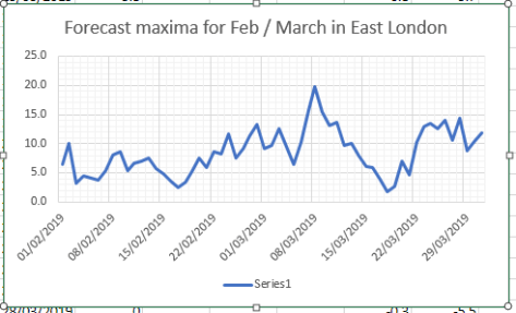
In summary, the probability at this point of at least one fall of snow before the end of February could be put at 100 per cent. Whether it will be abundant or merely a dusting is impossible to tell.
Elsewhere in the UK it has been similarly lacking in snow. During a visit to Fort William at the weekend locals told me that there has been no significant snow since October / November and that even frosts were few and far between. The lifts around Nevis Range looked forlorn against a green backdrop. And it wasn’t until I got to the summit of Ben Nevis and Aonach Mor that I saw any of the white stuff.
Strong winds, hail, sleet and snow were experienced in abundance when I climbed the UK’s highest mountain at the weekend.
To give us a chance of making it to the 1,345m summit and back we left Fort William in darkness. Heavy rain that had greeted our arrival the previous day had abated but the spooky balminess of this early January remained; a local thermometer was reading 11C at 7am!
A gorgeous purple hue tinged the early morning dawn as we began our ascent though it was not long before the rain returned.
Proceeding upwards, after about an hour, we passed another climber who was walking down, having abandoned his attempt because of ‘atrocious conditions’. “I’m more of an ice and snow climber,” he explained, telling us how wonderful conditions had been in Zakopane, Poland, just a few days previous.
Unperturbed we pushed on soon making it to the tarn – the Lochan Meall an t’Suiche. We had ideas to climb the Ben via the Carn Mor Dearg arête but a wrong turn and conscious that time was not on our side we turned back and continued on the pony track / tourist route. Just over two hours in we passed the ford, just below which the route begins zig-zagging its way up to the summit.
By now the rain started to get heavier. At around 900m it turned to hail. It was at this point that we passed another climber: “It’s snowing on the summit but you don’t need crampons,” he exclaimed before hurrying on down. We passed a further dozen or so walkers on our way to the summit; all of them looked like they couldn’t wait to get off the mountain. The rain was now a wintry mix of hail, sleet, snow and frozen rain – painful to walk into in the strengthening wind.
As the peak started to level out around 1,150m snow was now beginning to settle on the rime that had built up on the cairns; we’d got what we’d come for! It was here, however, that I realised my waterproof trousers weren’t so waterproof. First dampness then rivulets of water began flowing into my boots.
The peak was now well fogged in and for the first time I felt a bit uneasy, conscious of the fact that the wind was also still gathering strength. Regardless, my climbing pal continued to press on just ahead of me. Poor visibility concealed the summit which was still another 100m or so higher. Although he’d previously climbed the Ben (in perfect summer conditions) he’d forgotten exactly where the trig point was and was careful to observe the cornices to the side, so lethal to inexperienced walkers who fall through them every season.
We made a beeline for the bothy close to the trig point; my climbing partner, who was also trying to deal with waterlogged boots, was keen to change socks. At that point a gust of wind caught the bothy door – it smashed open leading to the rime that had built up on the hut to fall to the ground. I was starting to feel well out of my comfort zone and I persuaded him against the sock change, saying we needed to turn around and get down as quickly as possible. Despite both having crampons in our rucksacks I decided against spending more precious time trying to wrestle them on to our boots. Although the ground was coated in rime I knew that the warm front that was coming in was already lifting the temperature – and we’d cope without them.
The route down was easier if unpleasant. Once we’d descended far enough out of the cloud and wind I knew we’d be OK and it was just a case of taking it steady over the uneven cobbles.
Night was fast drawing in by the time we arrived back at the Ben Nevis Visitor Centre. As we called a cab for the short drive back to Fort William all I could think about was a hot bath back at the hotel and a welcome pint by the fireside.
All around Fort William it is frequently mentioned that conditions at the top are totally different and that the Ben should not be under-estimated. As someone with nearly four decades of experience of being in and around mountains I should know better than most. But Ben Nevis is not just any mountain and deserves complete respect.
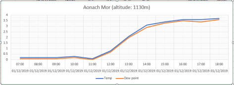
The meteorology of the climb
The temperature trace shows that the warm front arrived after 11amThe WSW wind was gusting F6/F7 giving a windchill of -5C and lower
* Despite the awful conditions I did manage to get a few photos, including the observatory where Victorian scientists lived for 20 years, gathering meteorological observations until 1904. Experiencing just a taste of the conditions that they would have had to endure makes their achievement all the more remarkable.
The observations have recently been fully collated and are providing valuable insight into the study of how mountain conditions have changed since that time.
** The following article was printed in the Lochaber News, 9th January, 2013
Stupidity can get you killed
The leader of Lochaber Mountain Rescue Team has issued a strongly-worded warning in the wake of a walker’s “act of sheer stupidity” in trying to tackle Ben Nevis in winter in trainers.
John Stevenson (58), who heads up Britain’s busiest mountain rescue unit, said a man rescued on Monday afternoon was fortunate to be alive after attempting the country’s highest peak without proper equipment for the conditions and time of year.
The 31-year-old walker was airlifted to hospital in Fort William after he fell while descending the 4,409ft, snow-covered Ben. He sustained a leg injury while walking on the main mountain track and managed to alert the police to his situation at about 4pm.
A full search and rescue operation was launched involving police, 18 mountain rescuers and a Royal Navy helicopter from HMS Gannet, Prestwick.
The injured man was located and airlifted from the Red Burn area, above Lochan Meall an t-Suidhe, and was treated at Belford Hospital for his injury and the effects of the cold.
Mr Stevenson said the incident could have turned to tragedy.
He said: “He’s an extremely lucky young man to have survived.”
“His equipment was just rubbish – he had nothing. He was wearing trainers and didn’t have a torch.”
“He did everything we tell people not to do. When we found him he’d lost one trainer, the backside was out of his trousers and he was wet and cold.”
“There’s no doubt in my mind that he would not have survived the night if he hadn’t phoned in on his mobile, and we were lucky enough to find him.”
“He didn’t actually set off on his ascent until 11am, having come straight off the train at Fort William. That’s just a ridiculous time to be starting out when darkness falls at about 4pm. It’s crazy and not on at all.”
“He made it to the summit okay but slipped on the way back down and managed to call the police on his mobile phone.”
Mr Stevenson added: “Initially he was on the so-called tourist path but he lost his way and veered off the path.”
“He slipped and hurt his leg but kept on walking – but realised he was lost and phoned the police.”
“He was talking to the police as he walked and then the phone just went dead. All the officer could hear was running water.”
“We had been alerted by this time and were on standby, so when the line cut out we all feared the worst.”
“I knew the only place on the top half where you can hear water running like that is the Red Burn, so we sent two members of the team up with the helicopter, as well as members on foot. Luckily the first two found the casualty pretty quickly. He had fallen but was okay. He’d lost his phone.”
Mr Stevenson said he found it increasingly frustrating that, despite annual messages from rescue teams, climbing organisations and the police, walkers were still heading to the mountains ill-equipped for the conditions.
“People need to be prepared,” he urged. “They need to heed the advice about having proper equipment and clothing.”
“The thing is, so many people get away with it every year, but unfortunately many don’t and end up injured – or worse.”
“The man on Monday was very lucky indeed and we could see he was extremely relieved to be off that mountain.”
Rain today (January 16th) is the first meaningful fall since before Christmas, putting an end to the 23-day long dry spell.
This meteorological drought, rare given that it spanned Christmas and New Year Storm singularities, these having 84 and 86 per cent probabilities respectively, was the 3rd equal longest winter drought.
The only other similar droughts in a list that dates back to 1887 were 19/12/2008 – 03/01/2009 and 17/12/1972 – 02/01/1973.
The last precipitation I recorded was from a weak occlusion that followed a cold front on the evening of December 23rd.
This synoptic set-up was followed by a build in air pressure that peaked on the morning of January 3rd; 1043.8mb was the highest reading in this area for at least 10 years and is the highest pressure I have measured.
A fuller version of London droughts in all seasons can be found here.
With all the snow falling in Austria I noticed that next month is the 20th anniversary of the Galtür avalanche that left 31 dead, 26 injured and left a trail of devastation.
The avalanche was considered the worst in 40 years. Three weather systems originating from the Atlantic accounted for large snowfalls up to 4m deep. Freeze-thaw conditions created a weak layer on top of an existing snowpack; further snow then settled. This, together with high wind speeds, created large drifts and caused roughly 170,000 tons of snow to be deposited.
Even more snow is expected in this and surrounding regions.
The extreme amounts will fall mostly on the north of the range with very little on the south side, more or less the opposite of what happened last year.
Of course Alpine snowfall, from year to year, has always varied greatly as this study of San Bernadino shows.
Weather models are continuing to struggle in the aftermath of the stratospheric sudden warming on January 1st. The GFS and ECMWF have flip-flopped: on one run decent northern blocking extends southward only for the dreaded European high to appear on the next.
Using a combination of QBO and ENSO data featured in my winter forecast and statistics from previous SSWs (including 2013 and 2018) achieved the following results shown in this graphic.
Although some days in the next week or so will be cold it is not until the 14th that conditions start to bite, the start of a week-long cold spell that will probably be more notable for cold than snowfall.
The rapid recovery in temperature would suggest that the Azores / European high making a return. With the MJO moving back and forth between phase 7 and 8, and looking at the behaviour of previous cold spells, this would make sense.
The GFS has been churning out some very strange charts of late
As for February, unless there are further SSWs to disrupt the polar vortex, and depending on its recovery, it is unlikely we will see a repeat of the winter of 1984/85 that I hinted at last month. The graphic below, however, would suggest another cold spell in the third week of February.
This year finished as the 7th warmest on record – some 0.8C warmer than the 1981-2010 average.
Only two months of 2018 were more than 1C below – the means of April, May, June and July were at least 2C above average.
Rainfall was less remarkable with the year finishing 97 per cent of average. The total of 584.4mm puts it as the 81st driest since 1797, just over 20mm wetter than 2017.
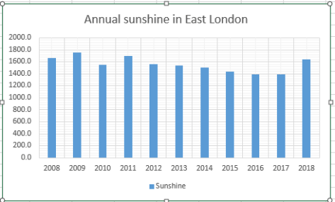
It was a sunny year with 1,641 hours of sunshine recorded. That’s 111 per cent of average, the 23rd sunniest since 1881.
December was most notable for benign weather, totally in contrast to last December which saw snowfall.
The mean temperature finished 7.3C, 1.7C above average, the mildest December for three years though still over 3C cooler than that record breaking December
Some 60.4mm of rainfall was recorded, 114 per cent of the 1981-2010 average, over 20mm less than last year.
Some 39 hours of sunshine were recorded, that’s 97 per cent of average, duller than last year.
Five air frosts were recorded though only one was colder than -1C.


 As the peak started to level out around 1,150m snow was now beginning to settle on the rime that had built up on the cairns; we’d got what we’d come for! It was here, however, that I realised my waterproof trousers weren’t so waterproof. First dampness then rivulets of water began flowing into my boots.


You must be logged in to post a comment.