Category Archives: weatherlore

Hurricane force in the Georgian era

Such was the force of the wind that the masses of masonry were carried 30 feet beyond the base of the tower penetrating not only the roof of the church but also the floor and breaking through the vaults to the foundation.

The account of a windstorm that severely damaged St John’s Church in Edinburgh in January 1818 was carried in the second volume of Luke Howard’s Climate of London.

1889 view looking east along Princes Street, with the church to the right in front of St Cuthbert’s Church and Edinburgh Castle public domain

Thursday morning 15th the barometer had fallen eight tenths of an inch it then blew very hard and during the whole course of the day slates and chimney pots were flying about in all directions. In the evening the gale increased and about five o’clock it blew a perfect hurricane.

The ‘perfect hurricane’ was referring to the Beaufort Scale which had been written just over a decade before in 1805. Obviously anemometers were not around at the time – the scale was merely to describe sea conditions to help sailors. A modern interpretation of hurricane force 12 estimates mean speeds 72 – 83mph.

The church in Howard’s account had only just been built, it’s dedication being completed on March 19th the same year. Howard continues:

In houses fronting the west a good deal of mischief was done in breaking the panes of glass, stripping the lead from the roof, dashing the cupola windows from their frames and shivering them to atoms. In the course of the fore-noon two of the small minarets on the top of St John’s Chapel at the west end of Princes Street gave way and fell without doing any material damage to that beautiful building . Not so, however, the effects of the evening the violence of the wind carried off the whole of the minarets, large and small, leaving the summit of the tower a perfect ruin.

Later the same year storms struck the south coast of England.

Ryde, March 5 One of the severest gales of wind that has been felt here for the last 37 years was experienced last night. It commenced about 4.30pm and continued with increased violence until 11pm during which time the greater part of the pier and several houses were demolished. The supposed damage is estimated at between four and five thousand pounds (£500,000 in today’s money) No lives were lost nor any damage done to the shipping.

Dartmouth We experienced a perfect hurricane last night at SSE.

Some four years later the storms were back.

On December 5 Howard reported that the barometer had been low for an unusually long period of 23 days, a mean of 29.4 inches with southerly and westerly winds.

Norwich The Mercury reported that the city experienced one of the most tremendous gales and heavy rain in living memory.

The gusts which followed each other were most terrific and threatened the safety both of the houses which actually rocked to and fro from the violence and their inmates. By the tremendous gale of wind on the night of Thursday last a brick wall of between seventy and eighty feet in length at Ipswich was completely blown down.

Brighton At 7 o’clock on the 5th a small squall came on from the WSW and raged until 9.30am during which the rain descended in one incessant torrent and the roar and fury of the wind is not to be described.

Considerable alarm was excited by it in many parts of the town several houses were nearly unroofed and one not quite finished five stories high in Russell Square was levelled with the ground. The chain pier works sustained further injury but not to the extent which had been anticipated. Fortunately there were no shipping in this part of the Channel last night or we might have had many wrecks at this time to have particularized. Several vessels were wrecked during the storm on Thursday night. At Dover many houses were injured by the tempest and some tenements were blown down.

Manchester The Guardian reported on “one of the most terrific gales of wind with which this town has been visited for many years”

It commenced about night fall from the south west afterwards veering round to the west and gradually increased in violence until about 12am when it blew a perfect hurricane accompanied by heavy rain. By 10pm the town was left in almost utter darkness the greater part of the gas lights being blown out and those which escaped extinction were so violently agitated by the wind as to afford but little light. Many families passed the greater part of the night by the fire side not daring to retire to rest until the gale had abated.

Warrington The cupola of the church near the George Inn was blown down and part of the roof destroyed. A windmill in the neighbourhood was also blown entirely down.

Liverpool The Mercury reported that a “remarkably strong gale of wind was experienced here accompanied with rain, sleet and hail which continued with little intermission until after 9pm when it increased in force and destruction bursting against the higher buildings of the town in sudden and stunning gusts.

The alarm was general and accounts are now pouring in upon us from all quarters of the melancholy effects of the storm both on shore and on the river

Falmouth A “tremendous gale from SW and WSW” was reported.

We scarcely recollect seeing a more heavy sea running between the castles of Pendennis and Mawes.

Monmouth Among the casualties in Wales was a huge elm tree situated in the grounds of Raglan Castle.

The venerable tree which formed a happy termination at the east end of the terrace measured 26ft in girth and from whose trunks the two limbs which grew from the head of it spread their protecting shade 22ft fell a sacrifice to the fury of the elements, being blown from its commanding situation into the mead below. During the violence of the late storm twelve fine elm trees of large dimensions were torn up by the roots in front of and in the grounds of Trevallyn Hall, the seat of George Boscawen Esq. One of the trees that grew in the centre of the lawn is much to be regretted. It was a very handsome ornamental tree whose branches spread over a large extent of ground and which was the admiration of those who noticed it. The circumference of the butt is 12ft and contains in measurement 322ft of solid timber it was planted about the year 1760 by the late Mr Boydell of Trevallyn.

Halifax A large chimney was blown on to the roof of a house next to the Sportsman Inn at Greetland. It burst through three floors taking along with it two children out of the middle room and depositing them in the cellar. Amongst the ruins were the father and mother and three children who all survived.

Bristol reported a “most tremendous gale of wind from the SW”. The Birmingham and Oxford mail coaches reported that roads were strewn with trees and branches while in the north of Staffordshire the wind gradually rose accompanied with showers and blew with terrific violence during the night.

The Salopian Journal reported on a “hurricane of ten hours continuance”. In Shrewsbury the driver of the Holyhead mail coach spoke of 90 trees blown down in Powys Castle.

Advertisement

London winter forecast 2018-19

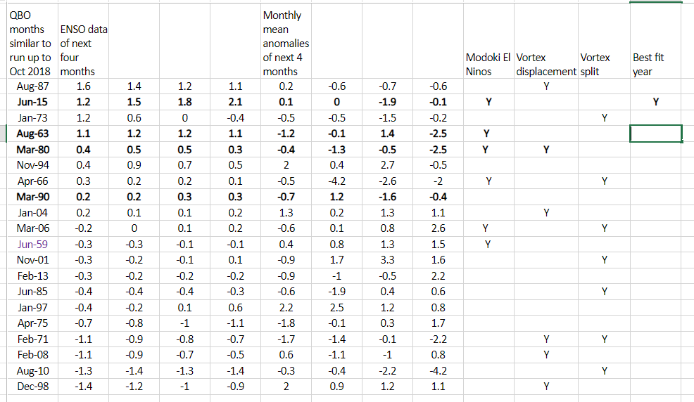
Long range modelled forecasts have been all over the place of late and, looking at the underlying signals, it is easy to see why.

When I’ve produced these forecast in the past, in terms of QBO and ENSO data, there’s usually a lot of analogues to compare with. This year, however, seems to be an exception.

Considering QBO first I looked back over data to 1950 and found nothing similar for October. However, looking over the whole series the cyclical nature of this circulation may give some clue.

bestfit

Some 20 months were revealed, ranging from June 1959 to June 2015.  Using NOAA’s  Niño 3.4 region I narrowed this list down to the few that had an ENSO value of around +1 with a rising trend. With NOAA’s forecast of a Modoki El Nino (one that occurs in the central Pacific) this narrowed the list to just 1 period: June 2015. Considering maxima anomalies this would give the following winter.

winter 2018-19 max anomaly.PNG

The above would suggest there being a general cool down through December with a cold spell starting just before Christmas into the new year? And another cold spell end of January into the first week of February?

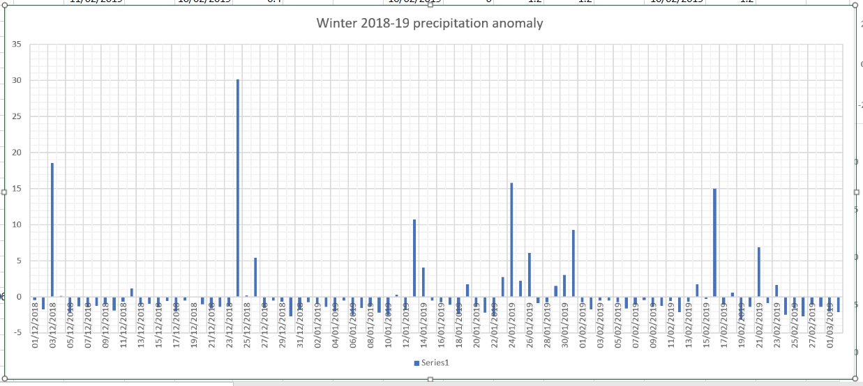
winter 2018-19 precip anomaly

The above precipitation anomaly chart would suggest a wetter than average December,  January and February, though February by much less so.

It’s been a very busy autumn so I’m keeping this short.

The below figures, particularly January and February, may be different in the event of an SSW occurring. In all then.

The mean:
December: +0.8C
January: -1.2C
February: -1.7C
Overall: -0.3C (broadly average)

Precipitation:
December: 158%
January: 155%
February: 120%
Overall: 134%


November: an Indian summer before turning cold?

With the mean temperature of both October and September finishing 0.2C below average it is probably safe to say that the weather is in an average kind of mood.

Conditions during the first part of November look changeable, according to the Met Office’s 30-day forecast . After mid month, however, the agency says the forecast is uncertain.

Now that much of the UK has had its first frost any warm spell in November will, correctly, be called an Indian summer. A singularity called the St Martin’s Summer occurs in 66 per cent of years, occurring between 15th and 21st and peaking on the 18th.

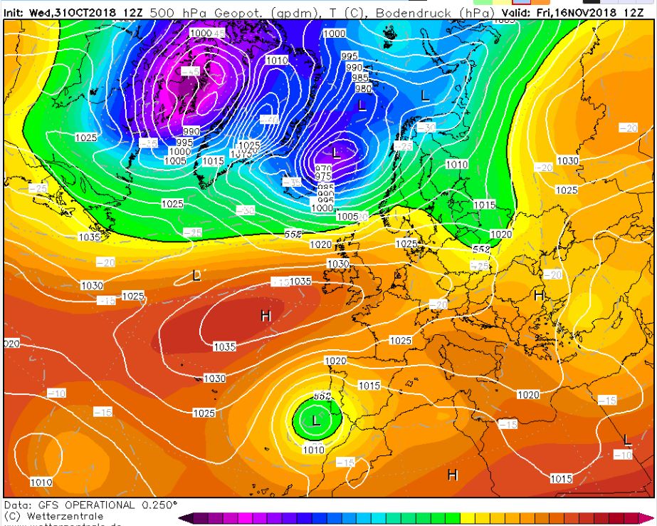
And, as if by magic, the GFS model today has this chart for the 16th, an Atlantic ridge of high pressure with daytime temperatures about 6C to 8C above average. Though warm during the day I would imagine there being a risk of fog forming at night

16th

Beyond that there could be a tendency for much more unsettled weather at the end of the month. The early December storms singularity occurs in 98 per cent of years, starting between November 24th and December 14th, often peaking on December 9th.

November, the last autumn month, can often surprise with its extremes, though it can also often be characterised by days of anticyclonic gloom. The warmest, coldest and wettest November conditions in London back to 1959 can be found here.


London’s October extremes since 1959

October is one of those months that can see both ends of the spectrum; from calm ‘mists and mellow fruitfulness’ and, rarely, frost, to wet and wild systems whistling in off the Atlantic, best known being the 1987 Great Storm and, more recently, the St Jude storm.

I’ve put together a few top 10s of stats for Wanstead, St James’s Park and Heathrow for the month of October.

october extremes

October SJP

Heathrow oct

Some national UK October values according to TORRO

Hottest: 29.4C March, Cambs – 1st 1985
Coldest: -11C Dalwhinnie 28th 1948
Wettest: 208.3mm Loch Avoich 11th 1916

In terms of climatology October maxima, considering the 1981-2010 average, shows a decline through the month, though around the 8th and 20th there is often a spike. This would reflect the October singularities; early October storms, between 5th and 12th, peaking on the 9th, occur in 67 per cent of years. St Luke’s summer, between 16th and 20th, peaking on 19th, also has a 67 per cent probability.
Mid-autumn storms occur between 24th and 29th October, with a 100% probability.

october average graph

The average rainfall graphic shows that downpour amounts are variable through the month. A tendency for dry weather around the 17th and 18th before the wettest days on the 20th and 21st.

October rainfall


Wild equinox brings memories of childhood

Wild weather in the run up to the autumnal equinox was frequently a staple of the Septembers of my childhood but it has been absent in recent years.

Since 2013 I have been recording the ‘wind run’ data on my AWS, a stat generated by the amount of times the anemometer spins.

wind run

The results show there has been nearly two-and-a-half times more wind than the 5-year average.

Stormy weather over the equinox is one of the less frequent recurring singularities. The meteorologist Philip Eden a few years ago noted that ‘Mid-September storms’ during the period of 17th to 24th September had a frequency of 60 per cent.

20th
The wind run was the highest on 20th

The same old weather every year?

Recurring weather patterns at certain times of the year are well known. The ‘Buchan Cold Spell’, ‘European Monsoon’ and Indian / St Martin’s Summer are all phenomena that have been studied extensively.

An article by the late meteorologist and broadcaster Philip Eden a number of years ago considered many of these patterns and found that, to varying degrees of reliability, they provided a guide to what the weather would be like at any given time of the year.

Considering climate change I wondered how much these patterns could still be relied on. Using my own pressure, rainfall and ‘wind run’ data (the total amount of daily wind) going back to the start of 2013 I had a look at the singularities for January and February

January patterns at the beginning, middle and end of the month appear to be the most reliable. However, it is only the ‘mid-Jan settled’ period that is most reliable.

singulariuty

pressure
The pressure trace most notably shows a general rise from the 17th, the date of last week’s windstorm, consistent with the mid-January settled singularity.

rain
Though this year’s ‘settled’ January spell saw rain the past 5 years have seen mostly dry weather.

windrun
Very little wind has been recorded around January 20th for the past 5 years

The early Feb settled spell occurs with very low probability: just 56 per cent. And this year the pressure, according to the GFS model, plotted below by WXCharts.eu, is predicted to be around 1040mb by February 2!

out to feb 1

new gif
This animation of the GFS model shows the idea of the Iceland low, which drives our SW’ly type weather, ‘taking a holiday’ to southern Iberia, possibly advecting any cold weather in the east to flood the UK

Looking at the results of the past 5 years it could be concluded that the patterns do still occur but because of the nature of the jet stream, which seems to meander far more readily than in the past, these stormy / quiet episodes are becoming shorter than they were in previous studies.


Murphy’s winter and weather prophets

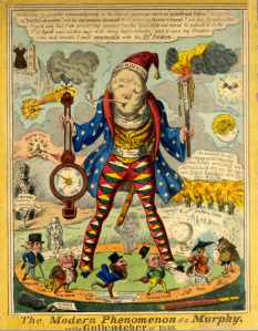
It is 180 years ago this month that Patrick Murphy shot to fame after successfully predicting one of the coldest Januaries on record.

murphy
anon, “The Modern Phenomenon of a Murphy the Gullcatcher of 1838” London Saturday Journal

The month, which had started mild, completely changed during the weekend of the 8th as a SE’ly wind set in. Hard frosts and snow became a daily feature with considerable falls across Scotland, disrupting mail and causing hardship for people and livestock.

By the 20th some of the lowest temperatures of the 19th century were recorded in London. At Greenwich -16C (-11C at midday) was reported at sunrise, while Blackheath saw -20C and Beckenham -26C. By the 27th the Thames at Greenwich was completely covered with ice at high water and elsewhere in the estuary ice floes were reported.

In some parts of northern Scotland, snow was noted to fall on most days between January 8th and May 3rd. Snow was also noted in upland areas of NE Scotland in June.

‘Murphy’s Winter’ as it became known made the astrologer from Cork a small fortune from the sale of an almanac, the contents of which also successfully listed the actual date when the frost would be at its most severe.

It was possibly the first long-range weather prediction that people through the ages seem to love, whether they are right or wrong.

Many characters have emerged over the years. Yorkshire’s Bill Foggitt, who used natural signals and animal behaviour during the previous autumn, was popular in the 1980s especially when he made a prediction of a harsh winter.

Others, including the Daily Express, who probably shouldn’t be mentioned in the same breath as Foggitt, are more about the clicks they hope to generate for their publishers than any earnest attempt at being right.

  • The mean temperature locally in January 1838 was -1.5C, the second coldest January in a series going back to 1797, and as cold as January 1963.
  • mean


Ophelia and mid-October storm trends

There is much anticipation in meteorological circles about the possible track of a deep depression spinning up the west coast of Ireland early next week.

The National Hurricane Center in Miami, on the 12Z GM run, puts Ireland and south-west England in the firing line of Ophelia.orphelia

The timing of the depression, coinciding with the 30th anniversary of the Great Storm, is remarkable and I wondered if there were other similar Atlantic storms through history.

A search through Martin Rowley’s excellent weather history site revealed that in October 1886, a small-scale but intense depression tracked ENE across central Ireland during the 15th, with lowest pressure estimated ~969mb.

16101886
The depression in October 1886 had a lowest pressure estimated ~969mb.

Gales, at least up to Storm Force 10, were reported by most ships and some coastal stations across the southern part of the British Isles, with ENE’ly gales across Scotland (north of the depression track). The low then moved slowly ESE to central-southern England (perhaps deepening a little) on the morning of the 16th, allowing N’ly gales (at least Storm 10) to affect the Hebrides.

Many trees were blown down across Ireland, the English Midlands and counties along the English Channel. Damage also occurred to standing crops, and the high winds were accompanied by heavy rain, which brought river flooding to England, Wales and Ireland, delaying the harvest, which was already compromised by the wet/windy weather. Some bridges were swept away.

14101881
October 14-15, 1881

Five years earlier, on October 14-15, 1881, an exceptionally severe gale (Force 9-10, locally Force 11) caused extensive damage across the British Isles & areas adjacent to the North Sea, especially along the north-east coast of England & across the eastern parts of the English Midlands.

Some 108 ships were reported missing. Inland, this gale was considered a ‘great storm’ with extensive loss of timber, especially in Scotland. One particular tragedy involved the destruction of almost the entire fishing fleet from the port of Eyemouth in Berwickshire.

The morning (14th) had been fine with near-calm wind. Some 41 vessels, mostly big deep-sea boats sailed out. In the middle of the day, the wind fell light, and then the storm struck suddenly. Nineteen of the boats were lost and 129 men failed to return to port.


The deadly hurricane of October 1817

Two hundred years ago this autumn a devastating hurricane ripped through the Caribbean. Thousands lost their lives as the winds destroyed hundreds of homes, ships and sugar plantations.

An account in Luke Howard’s The Climate of London reports the loss of 1,800 lives in Martinique alone during the storm that was the most destructive in at least 37 years.

One extract from a ship’s officer on November 30th, 1817, reports on the devastation seen on St Lucia: “We were struck with astonishment at the total change in the whole face of the country.

“We left it the day before the hurricane a beautiful rich green and every thing in a most flourishing state. It has now the appearance of a severe European winter. We went on shore of the 7th of November the scene of destruction which then presented itself is far beyond my power of description.

“On Pigeon Island three houses only are left standing out of nearly 259 the rest with the church are almost totally demolished.”

I have attached the entries below.

hurricane 1

hurricane 2

hurricane 3

Poor start to June? That’ll be the Euro monsoon

Widespread heavy rain and gales across the UK have made the start of summer feel very unseasonal. But the conditions, which follow an extended period of mostly dry weather, are very typical for early June.

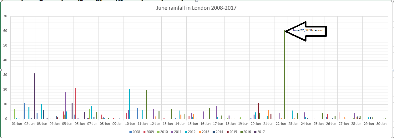
june rainfall with record
The pattern for June over the past 10 years reveals the month often starts unsettled before drying up in the final week

The ‘NW European monsoon’ is one of the most reliable ‘singularities’ on the annual weather calendar. Though it sounds very unscientific that the atmosphere can remember how it behaved on a certain date in previous years much statistical work over the past 170 years highlight tendencies for unusual weather at particular times of the year. These tendencies were first identified by the German climatologist, A.Schmauss, in 1938.

While the pattern isn’t set in stone statistics show that the probability of the euro monsoon occurring between June 1st and 21st is 77 per cent.

GFS rain to 15th
The GFS operational run suggests an unsettled outlook

One of the most notable inclement spells of weather in June happened during the D-Day landings in 1944.

With the changes in ice at the North and South Poles, together with the massive positive temperature anomalies last winter,  it would be thought logical that this would have some bearing on the general pattern this year. But polar ice is only one variable to consider when trying to predict the world’s climate.