
The knife-edge situation for snowfall across England today set me off wondering if there was a way to forecast snow locally to a given location.
Temperature, dew point and altitude are all crucial to forecasting snow, as is precipitation intensity that can lower the wet bulb temperature, the ‘rain turning to snow’ scenario. Less well known is the role air pressure plays in these events, such as the one on December 10th which caught many forecasters by surprise by its intensity.
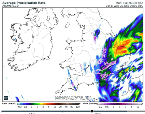
While various models continually improve in their skill at warning us of impending rain / snow events that often cause chaos, their resolution can still struggle and especially when the event more or less becomes a nowcast.
In the International Standard Atmosphere (ISA) there is a 1 hPa difference for each 30 feet vertical change in height in the lower levels.
If we take a forecast pressure as 970 hPa, the difference between standard conditions (1000 hPa) and 970 hPa is thus: 30 hPa
30 hPa * 30 = 900ft height variation.
You then consider local altitude: in my case 18m (59ft)
So 59ft – 900ft = 841ft (256m)
A simple table, therefore, to consider air pressure is thus.
1000 hPa = 0m
995 hPa = 27.6m
990 hPa = 73.3m
985 hPa = 119.1m
980 hPa = 164.8m
975 hPa = 210.5m
970 hPa = 256.2m
965 hPa = 301.9m
960 hPa = 347.7m
955 hPa = 393.4m
950 hPa = 439.1m
Looking at the system today the pressure rose quickly after the centre passed, leading to a 1hr (at best) window of snow falling. As the pressure rose, and the temperature picked up only slightly the snow turned back to sleet and then rain.


http://weatherfaqs.org.uk/node/152
http://aeropowerflightschool.com.au/how-to-calculate-pressure-heightaltitude/

please can u explain further? Do u mean lower air pressure essentially simulates an increase in altitude with regard to a particular place? thanks.
LikeLiked by 1 person
Yes, but it is restricted to that particular location and that particular point in time. It is obviously of more benefit to anywhere that is close to sea level.
LikeLiked by 1 person
This event of snowfall and very low pressure is probably the one that sticks in my mind the most. https://wp.me/p2VSmb-2AI
LikeLiked by 1 person