Tag Archives: Aldersbrook

A chilly and dry autumn on the way?

Anomalies of the past two months throw up some interesting singularities as we head into late summer and autumn – with a hint that we could be heading for a much colder than normal December.

Using stats from the past 60 days revealed the following years. Those most similar to the current ENSO situation are highlighted in bold.

The most negative month on average will be December.

In terms of rainfall those hoping for a deluge look likely to be disappointed, at least in the south-east, with a continuation of synoptic conditions that favour drier than average weather.

The best chance for a wetter than average month appears to be September though, given recent synoptics, this is likely more a result of trough disruption than any sustained period of Atlantic-driven fronts.

Advertisement

Sunless days and washouts

The weather of late has been in stark contrast to the mostly dry, sunny (if a bit chilly) spring many enjoyed. Indeed the first half of June saw more of the same and, locally, was the warmest start to the first meteorological summer month since at least 1959.

My memory of summers years ago was that it was often hot and sunny but I also remember countless days of staring out the window for hours waiting for relentless rain to let up.

Looking back at sunshine stats to 1959 there has been over 4,400 days where no sun was recorded, roughly a one in five chance of a totally cloudy day.

Considering the months where the absence of sun is most noticed, May to October inclusive, the probability decreases to just under one in ten.

To decant these to ‘washout days’ I’ve only included those sunless days that were also ‘wet days’ where 1mm or more of rain was recorded. The probability further decreases to just under one in twenty.

All very interesting but were there more washout days decades ago or is the memory playing tricks?

Looking overall shows an increase since 2013. Out of all the months the most notable change has been August.

Spring in Wanstead Park

Spring in this neck of the woods was really mixed.

A chilly start to March became fairly benign before ending with the warmest March day locally since at least 1959.

April then turned much colder and drier; just 2.4mm of rain fell during the month – the driest April since 2007 and fourth driest in a local rainfall series back to 1797! Sunshine was abundant with over 200 hours. But clear skies at that time of year, with a polar continental airmass, often means air frost. And the ten recorded overnight was far higher than normal.

May saw things warm up slightly but the month still finished a degree colder than average. Some 80mm of rain fell which is over one and a half times what we’d normally expect. The wettest May since 2007 – the month playing catch up on the total absence of April showers that bring the spring flowers! It was a dull month with only 126 hours of sunshine, 69 per cent of average – the dullest since 1990 was third dullest back to 1881.


In terms of flora and fauna the colder weather played havoc with the trees, bud burst coming much later than recent years. As I write this on June 6th some of the later budders like false acacia have only just come into full leaf. The birds, as they normally do, just seem to get on with it raising their young. I’m not sure what the food supply has been like but judging by the amount of healthy juvenile fledglings I’ve seen I would guess that it has been a good season so far?


Here’s the stats.
March 8C (+0.3) 30.9mm (76%) 90.9 hours (84%)24.1C on 30th (a record that had stood since 1965)
April 7.2C (-2.6) 2.4mm (5.5%) 202.6 hours (127%)
10 air frosts in April, much higher than normal
May 12.1 (-1) 80mm (156%) 125.6hours (69%)
Spring 2021: Mean Thermometer: 9.1C (1.1C below average, coldest since 2013, 111th coldest) Rain Cloud with rain: 113mm (84% of average, wettest since 2018, 150th wettest ) Sun Sun with rays: 425.4 hrs (94% of average, dullest for three years. 51st dullest) The average masked extremes.

The green lung of Wanstead

The tree canopy cover map on the Mayor of London’s website reveals just how blessed Wanstead’s inhabitants are in terms of clean air relative to the proximity of the City.

Those living closest to the junction of Wanstead Park Avenue and Northumberland Avenue benefit most from Wanstead Park, Wanstead Flats and Bushwood.

green lung

city green lung

Wild swimming in Wanstead Park?

Lewisham’s Beckenham Place Park will next year be home to a new wild swimming lake, thanks to a plan to make London the world’s first National Park City.lewisham pool

The scheme put me in mind of the Shoulder of Mutton lake in Wanstead Park which, decades ago, used to host swimming galas and other events. Long-time residents of Aldersbrook will remember the jetty and diving board that stood at the edge of the lake before falling into disrepair that led to their removal.

With millions set to be spent shoring up the dams of the park’s lake system it is surely feasible that the City of London Corporation can reopen Shoulder of Mutton to swimming while the work is undertaken.

While being cheaper than a lido it would provide an excellent resource and give local residents the chance to enjoy once more swimming in natural surroundings, just like in the Serpentine and Hampstead Ponds.

beach
The Shoulder of Mutton pond has a natural beach and once hosted swimming galas and diving competitions


A new weather station for Wanstead

Wanstead has a new automatic weather station to complement the one set up in November 2012.Screen Shot 2018-02-13 at 19.13.20

The new AWS, situated in the grounds of Wanstead Golf Club, comes thanks to Friends of Wanstead Parklands. Data from the unit, which is sited very close to where Wanstead House once stood, will be used to help monitor the levels of the park’s lakes.

The sensor unit, 750m NNE of the weather station wansteadweather.co.uk on the Aldersbrook estate, is much better exposed and will hopefully offer more accurate wind and sunshine readings. It will also provide a chance to further investigate the area’s microclimate.

The station has already shown that the golf course is warmer on a radiative cooling night than the Aldersbrook Estate. Screen Shot 2018-02-18 at 14.22.08

The AWS can be found at WeatherCloud https://app.weathercloud.net/d0507444306#profile

Also at Weather Online
https://www.wunderground.com/personal-weather-station/dashboard?ID=ILONDON737

It also tweets hourly and provides an automatic 24hr daily summary. You can follow it @WansteadParkWX

Hourly tweets and all things weather continue as normal at @wanstead_meteo

wxmap.PNG

Summer 2017 review

Summer 2017 was a season of two halves, the mean temperature of 18.5C (1.3C above average) made it the tenth warmest summer since 1797.

Though it was warm overall it was also wet. Nearly 234mm of rain were collected, 159 per cent of average, making it the wettest summer since 1987.

Just under 535 hours of sun were recorded, 94 per cent of average and the sunniest summer for three years.

summer 2017 mean
The graph of the mean temperature for the 3 months shows a marked decline from the second week of July

summer 2017 rain
There were at least 3 falls of rain greater than 30mm over 24 hours though classic thunderstorms of recent years were notably lacking

summer 2017 sun
Sunshine was broadly average


August 2017: average temps, wet

The final summer month proved to be a disappointment for anyone wanting a return of the heat in June.

The mean temperature finished 17.4C, 0.8C below average and the coolest August for three years.

Some 70.2mm of rainfall was recorded, 140% of the 1981-2010 average. Just over 170 hours of sunshine were recorded, 88 per cent of average.

To view full stats follow this link:http://1drv.ms/1kiTuzv

August 2017

The wettest summer in 20 years

The 8th and 9th of August 2017 has produced probably the most miserable weather of this summer.

A rainfall event that began just after 8am on the 9th deposited nearly 36mm of rain in the Wanstead area over 14 hours.

The 09-09 total of 33.7mm made it the fourth greatest daily August rainfall since 1960.

The heaviest rain fell in a fairly narrow band, as shown by the official 24hr totals on ogimet.com. The low pressure system also produced a lot of rain for the east coast in the previous 24hrs with Bridlington recording over 56mm.

The rain brings the summer total to 207.7mm, just 0.6mm short of the amount recorded in 1997. Though it has been wet it is still a long way short of the wettest summer on record: some 391mm were recorded here in 1903.

In terms of temperature it has been a chilly start to August; the mean temp currently stands 1.2C below the whole month average. Considering CET it has been the coldest start to the month for 30 years.

July 2017: wettest since 1960

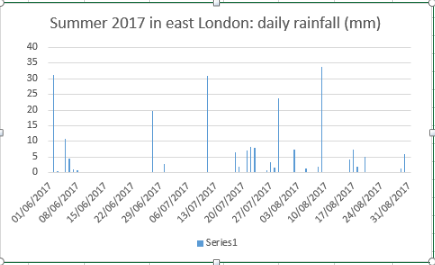
July 2017 was the wettest since 1960. Some 92.3mm of rain were recorded which is 212 per cent of the 1981-2010 average.finger cloud on 7th

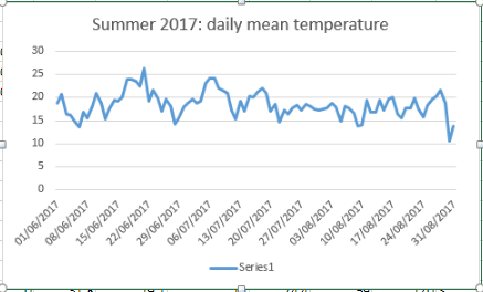
Although the opening third of the month saw a continuation of the June heatwave temperatures gradually returned to normal values to leave the mean for the month at 19.2C, that’s 0.7C above average.

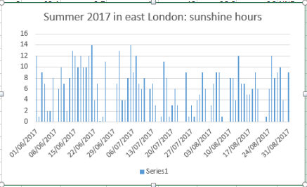
With all the rain sunshine totals were down. Some 167 hours were recorded, that’s 87% of average.

Though the rainfall total was impressive it is well short of the record of 164.2mm set in 1834, and is only 35th in the list going back to 1797.underlit

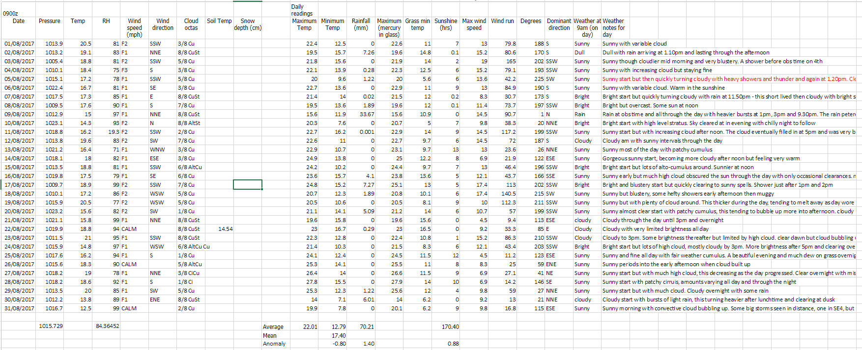
Summary for July 2017

Temperature (°C):
Mean (1 minute) 18.9
Mean (min+max) 19.2
Mean Minimum 14.7
Mean Maximum 23.7
Minimum 9.4 day 12
Maximum 30.5 day 07
Highest Minimum 18.3 day 06
Lowest Maximum 19.0 day 24
Air frosts 0

Rainfall (mm):
Total for month 92.3
Wettest day 30.8 day 11
High rain rate 56.4 day 29
Rain days 10
Dry days 21

Wind (mph):
Highest Gust 17.4 day 27
Average Speed 2.9
Wind Run 2163.5 miles
Gale days 0

Pressure (mb):
Maximum 1024.2 day 16
Minimum 996.8 day 31

Total hours of sunshine 167

In terms of the rest of the summer a look at the ECMWF control run out to 10 days suggests an unsettled start to August with the jetstream centred right over the top of the UK. Things may improve as the Azores high attempts to exert more influence – so perhaps more in the way of sunshine than of late. In terms of heatwaves it is impossible to tell at this range.mid level

Here follows the full weather diary for July. To view full stats follow this link:http://1drv.ms/1kiTuzv

1st: Cloudy but with sunny spells developing, these growing longer in length by evening.
2nd: Sunny with just a few light cumulus.
3rd: Sunny start though with plenty of cloud around, this tending to thicken after lunch with odd spot of rain.
4th: Sunny and very warm early then tended to cloud over before sun returned in the late afternoon and evening. Some very unstable low to mid level cloud.
5th: Sunny with just a few cirro-cumulus. Feeling very warm with cloud bubbling up in the evening, however forecast storms failed to materialise.
6th: Sunny with cirrus and dotted cumulus. This tended to thicken late morning though sun stayed out and became hot and humid.
7th: Sunny with lots of high-level cirrus and cumulus most of the day.
8th: Bright but mostly cloudy start, the cloud tending to vary through the day. Sunny after 4pm. Warm overnight.
9th: Bright but mostly cloudy start, the cloud tending to break and vary through the day.
10th: A mostly sunny morning and lunchtime until 2pm when it clouded over.
11th: Cloudy with some bright breaks at first. Cloud thickening with rain by noon, this falling sporadically before getting going after 5pm and stopping by 3am.
12th: Cloudy, damp and close start.
13th: Sunny with variable cloud until noon when there were just bright spells.
14th: Cloudy but with a few breaks around mid morning. Turning cloudy again before sunny spells in the evening.
15th: Cloudy with some sporadic rain as warm front blew through and close. Very limited brightness.
16th: Cloudy with some bright spells. Feeling warm and humid.
17th:Sunny with just a few cirrus drifting around. Feeling hot, cloud thickened from the west in the late afternoon.
18th: Sunny with variable cirrus and cirro cumulus through the day. Feeling very warm. Storms began building with supercell to west of London and over Chilterns.
19th: Cloudy, dull start and very humid with heavy mist – the cloud tended to lift to give sunny spells in the afternoon.
20th: Drizzle after shower before obs time, then showers through to 1pm.
21st: Cloudy start but with sunny spells developing. Clouded over in evening with intermittent heavy rain at 11pm and through the early hours.
22nd: Cloudy but with sunny intervals developing around noon. Heavy showers developing with thunder at 2.30pm and 3.07pm.
23rd: Bright with variable cloud
24th: Cloudy with light, showery rain from northerly airstream that originated in the Med.
25th: Cloudy with light rain just after obs time.
26th: Cloudy with occasionally rain. Feeling warm and a late clearance. Breezy and chilly overnight.
27th: Cloudy but bright and sunny spells developing. A very heavy shower at 1pm.
28th: Bright start but clouding over.
29th: Sunny start with cloud increasing after noon to leave overcast before patchy rain moved in. This falling more heavily at 5pm before clearing to further showers. More rain overnight before a strong squall arrived at 2.45am and lasted an hour with further bursts of rain through the night –  two claps of thunder and lightening during squall.
30th: Sunny with variable cloud through the day. Very warm in the sunshine
31st: Sunny with variable cloud throughout the day.