Category Archives: Heathrow weather

July 2019: a new Tmax record

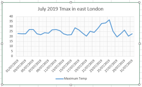
July 2019 saw the month’s daily maximum record broken on the 25th with a high of 36.8C, The reading beat the previous record set on July 1st 2015 by 0.8C and was the second highest reading recorded in this area. Cloud that drifted in mid afternoon put paid to any chance of all-time record though Cambridge, further north, managed to break the UK record with a reading of 38.7C. This temperature set in the Botanic Gardens beat the previous record of 38.5C set in Brogdale, Kent, in 2003.


north
The weather enclosure in the Cambridge Botanic Gardens meets WMO guidelines

Although it has been mentioned that the Cambridge site appears to be overdeveloped it meets the WMO standard and the Met Office are happy with the record.

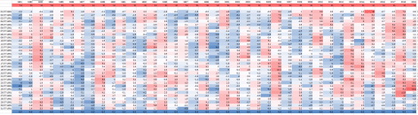
Compared with 2003 the heat this time was far more widespread and further north, with many stations recording higher values than 2003, as shown by these 24 hours to 6pm readings below.


In 2003 some 44 stations recorded 30C or above whereas this year some 67 reached 30C or higher.

Though the heat was record breaking it was much shorter lived than 2003. Like last month and July 2015 the 9-day temperature trace is far more ‘pointed’ – perhaps a symptom of the changing behaviour of the jet stream.

Overall the monthly mean finished 19.9C, that’s 1.4C above average though 1.8C cooler than last July – the warmest month on record.

Rainfall at 61.5mm, was 141 per cent of average,  the wettest for 2 years. Sunshine, at 165hrs, is 85 per cent of average and well down on last July’s 273hrs.

To view full stats follow this link:http://1drv.ms/1kiTuzv

2019july
‘Feels like’ maxima.
juky feels
June 1981-2019 maximum anomalies
july all.PNG


The 12 month rolling rainfall total is…

Summary for July 2019

Temperature (°C):
Mean (1 minute)  19.8
Mean (min+max)   19.9
Mean Minimum     14.7
Mean Maximum     25.1
Minimum          9.2 day 03
Maximum          36.8 day 25
Highest Minimum  19.6 day 23
Lowest Maximum   19.5 day 27
Air frosts       0
Rainfall (mm):
Total for month  61.5
Wettest day      20.6 day 19
High rain rate   16.1 day 18
Rain days        10
Dry days         21
Wind (mph):
Highest Gust     16.8 day 20
Average Speed    2.2
Wind Run         1664.1 miles
Gale days        0
Pressure (mb):
Maximum          1029.0 day 03
Minimum          1004.8 day 30
Days with snow falling         0
Days with snow lying at 0900   0
Total hours of sunshine        0.0
Advertisement

More anomalous warmth for late May Bank Holiday?

Weather models are hinting that this coming bank holiday weekend could be very warm indeed, with one WX Charts animation suggesting that a positive anomaly of 12C could be possible on Monday.

A date record looks a formality and, unless there’s a downgrade, new monthly high temperature records at stations across the south-east look a possibility.

While it looks very warm it is too early to start talking about heatwaves. And, considering the pattern since late February, with hot and cold alternating weekly, a brief return to much cooler conditions at the beginning of June can’t be ruled out.

The British record high temperature for May is 32.8C, reached on two occasions:

Camden Square, London May 22nd 1922. The same station recorded this value again on May 29th 1944, along with Regents Park, Horsham and Tunbridge Wells.

The national date record for the 28th, according to TORRO, is 30.6C at Camden Square.

Locally the highest temperature recorded in this area in May is 32.1C on May 27th 2005. The date record I recorded is 26.5C in 2012.


GIF

London’s December extremes since 1959

I’ve put together a few top 10s of stats for Wanstead, St James’s Park and Heathrow for the month of December.

Probably most notable is how the month in 1978 lurched from being very mild and wet to very cold in under three weeks later, setting up one of the coldest-ever winters.

Screen Shot 2017-12-02 at 12.41.15

dec recs

December Heathrow

Some national UK December values according to TORRO

Hottest: 18.3C Achnashellach – 2nd 1948
Coldest: -27.2C Altnaharra, Highland – 30th 1995
Wettest: 199.1mm Dalness, Highland – 17th 1966

Climatology

Here’s a couple of graphs showing the maxima and rainfall. Notice the spike just before Christmas day which reflects the singularity which has an 84 per cent probability.

december maxima.PNG

December minima.PNG

december rainfall.PNG

London’s November extremes since 1959

I’ve put together a few top 10s of stats for Wanstead, St James’s Park and Heathrow for the month of November.

Probably most notable is how the month in 2010 lurched from being so warm at the start to so cold three weeks later, setting up December to be one of the coldest on record.

wanstead

November SJP

heathrow

Some national UK November values according to TORRO

Hottest: 21.7C Prestatyn, Clwyd – 4th 1946
Coldest: -23.3C Braemar, Grampian – 14th 1919
Wettest: 211.1mm Lluest Wen Reservoir, Rhondda – 11th 1929

November climatology

In terms of climatology November maxima, considering the 1981-2010 average, shows a steady fall until the 15th. And another steady fall to the 22nd before things level off. This would reflect the November singularities; St Martin’s Summer, between 15th and 21st, peaking on the 18th, occurs in 66 per cent of years. The Early December storms singularity can arrive this month, on the 24th, the air off the Atlantic raising the mean temperature.

november average maxima

The average rainfall graphic shows that downpour amounts are variable through the month. A tendency for dry weather around the 15th reflects the St Martin’s Summer singularity.

november rain

This graphic shows the average 9am air pressure in November since 2013.

pressure


Phew! What a scorcher…

I’ve seen this phrase uttered more than once over the past couple of days thanks to high temperatures and humidity. But ask anyone to define a hot day and you’ll get a different answer every time.

Growing up in the 1970s / 80s redtop newspapers would use the phrase once the mercury was nudging 80F (26.7C). But to ‘scorch’ you need sunshine, preferably at least 10 hours of it. Considering statistics from the Heathrow airport climate station in west London there have been 463 scorchers since 1959, the most recent happening on July 5th with 29.5C recorded and 13.9 hours of sunshine. There have now been 9 scorchers this year, already matching the number that were recorded in 2014 and only 3 short of last year.

But even with last month’s heatwave this year has some way to go, however, to match the amount measured in 1976 and 1995: 31 days!

scorchers