London’s choked by leaving the EU

This month marks the 60th anniversary of the Clean Air Act, a piece of government legislation prompted in part by the Great Smog of December 1952 that caused between 4,000 and 12,000 premature deaths.boris

Air quality in the capital has vastly improved since those days of ‘pea souper’ fogs. A study of sunshine in Greenwich and other sites around east London reveals that winter months are, on average, around 18 per cent sunnier today than they were in the same period before the act was implemented in 1956. Though the cause of this is possibly partly because of a decline in winter anticyclones – weather systems that can give weeks of dull, murky conditions – further environmental legislation has helped.

Though the sky is clearer conditions at street level have grown steadily worse in recent years. During the first week of 2016 it was revealed that parts of the capital had already breached annual EU hourly limits for nitrogen dioxide – a pollutant that causes thousands of premature deaths through respiratory problems each year. A study last year showed that nearly 9,500 people die early each year in London because of long-term exposure to air pollution, more than twice as many as previously thought, according to the research.

Although action is being taken to reduce pollution from diesel buses, taxis and lorries the figures reveal that we are once again getting to the level of deaths caused by the Great Smog. The new mayor of London, Sadiq Khan, seems to be taking pollution a lot more seriously than his predecessor with a number of initiatives announced – making London compliant with EU legal limits well before the government’s target of 2025.

However, the mayor has also sent out conflicting messages by saying he backs the expansion of City Airport – you can’t have it both ways. And, if we do leave the EU, what will replace these EU legal limits?

With the current political situation lurching from one disaster to another I fear that the environment will get pushed well down the agenda. The current list of candidates vying to take over from David Cameron as prime minister include ‘dark horse’ Andrea Leadsom, the energy and climate change minister, who has been an ardent supporter of fracking. And on coal she recently sparked controversy in February  where she assured the industry the pledged 2025 coal phase-out was just a consultation and encouraged it to suggest what ‘unabated coal’ means.

The many benefits of EU membership got lost in the debate over the last few weeks – improvement in the environment being one of them. It is why, without the beady eye of Brussels keeping watch over us, that we must ensure that the next government stick to their promise of continual improvement to the capital’s air quality.

East london winter sunshine totals
Winter sunshine totals were falling before we joined the EU. Since 1973 a general upswing is observed. On average there is 18% more sunshine during winter months since we joined the EU compared with the same period before joining the Common Market


June weather can be flaming horror show

The past week has produced the highest 24-hour rainfall total recorded in Wanstead since at least 1960. The multi-cell thunderstorm on Wednesday night saw 60.8mm fall, most of it in two hours, bringing flash floods to the surrounding area. The spectacular lightning and thunder that accompanied it was almost a side show such was the intensity of the rainfall.

rainradar
An image from the Home & Dry app revealed a succession of dark red echoes passing over our area. The heaviest rain seemed to run on a line from Battersea to Romford

I was unfortunate enough to be riding home right in the middle of the event: the entire length of the Mile End Road bore a resemblance to a shallow river, the heavy rainfall bouncing back off the Tarmac high enough to create what felt like a powerful drench shower.

The legacy of the downpours caused chaos in the morning and evening rush-hours. Many commuters were stranded at London terminals including Waterloo station because of flooded tracks, possibly robbing many of the chance of voting in the EU referendum. It will never be known if this would have had a bearing on the final result.

Many people think of June as a warm, summery month. The term Flaming June  is regarded in most peoples’ subconscious as a reference to past weather. That it is a actually the name of a painting is often missed. Looking back through our local history there has been many notable events of thunderstorms and prolonged rainfall. In 1903 a record-breaking 59-hour deluge left vast swaths of the borough inundated.

list
The offical UK weather station totals all recorded less than Wanstead

This weekend 200 years ago, during the Year Without a Summer, a powerful tornado, strong enough to carry away objects weighing 60lbs, tore through the Edgware Road area in west London. Luke Howard recorded the event in the Climate of London.

At two o’clock being a still sultry day a whirlwind passed over the nursery ground of Mr Henderson in the Edgware Road which lifted seven lights from the greenhouses and carried them to the height of the highest elm trees, each of the lights weighs 50 or 60lbs at least. At the same time two garden mats were carried to an immense height so that the eye could not distinguish them.

The following day “extremely heavy and prolonged rain from 9am (26th) to 9am on 27th gave 2.95 inches”. This total of over 52mm is notably high though not a record.

This weather was a continuation of what had been an awful May and June – cold with more than twice the average rainfall in June.

The weather then was not unlike what we have experienced this month. Indeed, a look at the weather throughout this year was similar as this graph shows.

compared

Though the mean temperature at times bears a close resemblance this year is no comparison to 1816: The mean then was running at 6.2C, over 3 degrees colder than today.
Mean pressure was also lower being 992.1mb; the 2016 mean 9am pressure is 1010.6mb.
Perhaps not surprisingly this year’s rainfall rainradar
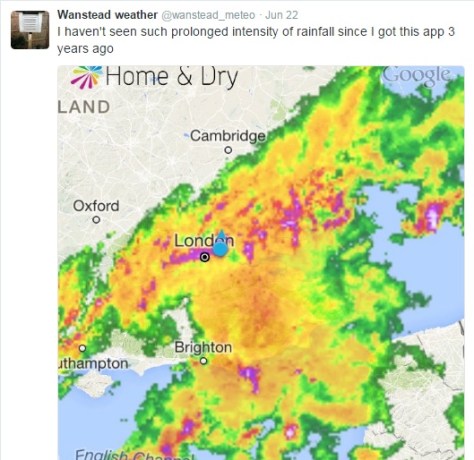
actually trumps 200 years ago; the running total for rainfall here is 390.1mm, higher than the 309.6mm recorded in 1816.

The dreary summer and frequent thunderstorms of 1816 inspired Mary Shelley to write Frankenstein. A summer vacation in Switzerland led her to spend much of the time indoors. She, along with Lord Byron and John William Polidori entertained each other with a contest to write the scariest story of all. The unseasonal conditions, along with this dare, led to the creation of Shelley’s Frankenstein: The Modern Prometheus— as well as Polidori’s novella The Vampyre and Byron’s long-form poem, The Darkness.

It will be interesting to see if this June’s weather, along with momentous political changes here and in Europe, produce more fine fiction from the this and the next generation of writers.

wind
Wind speed during the event from 2300 to 1000
temp
Temperature during the event from 2300 to 1000
pressure
Pressure during the event from 2300 to 1000
raintoday
Rainfall from 2300 to 1000
tipper
Rainfall rate from 2300 to 1000


Brexit to bring back those halcyon summers

I’m joking. But with the lies and half-truths spouted by both sides of the EU referendum debate it is a statement I wouldn’t be surprised to hear uttered in this last full week of campaigning before June 23.

This preposterous statement, however, got me thinking that perhaps there may be some truth that summers really were better before Britain joined the then European Economic Community with Denmark and Ireland in 1973.

But comparing the past 43 London summers with the period of summers from 1930-1972 shows that this is not the case in terms of temperature and rainfall.

Screen Shot 2016-06-13 at 13.17.20
Summers during the period 1973-2015 are on average 0.8C warmer than summers 1930-1972
Screen Shot 2016-06-13 at 13.22.19
A look at rainfall shows the average since 1973 is 84% that of the period 1930-1972
Screen Shot 2016-06-13 at 13.35.47
Average sun since 1973 is broadly the same as period 1930-1972 though has recently dipped

Perhaps it is just our minds playing tricks on us when we think back to summers being better than what they are today, and before EU membership?

Voter turnout and the weather

Over the years it has been argued that weather can affect voter turnout and therefore the result of an election. One Dutch study states: “We find that the weather parameters indeed affect voter turnout. Election-day rainfall of roughly 25 mm (1 inch) reduces turnout by a rate of one per cent, whereas a 10-degree-Celsius increase in temperature correlates with an increase of almost one percent in overall turnout. One hundred percent sunshine corresponds to a one and a half percent greater voter turnout compared to zero sunshine.”

Screen Shot 2016-06-13 at 14.24.26
Weather for the referendum on June 5, 1975, was mostly fine nationwide. A temperature of 21.3C was recorded at Greenwich after an overnight low of 7C. It was the start of a settled period of summer weather that had followed a cool and miserable late May and early June. Sound familiar?

In June 1975 the electorate expressed significant support for EEC membership, with 67 per cent in favour on a 65 per cent turnout. Though the turnout looks low you certainly couldn’t blame the weather.

In terms of this year, with ten days to go, it is too early to say for sure what the weather will be like on June 23rd though the GFS model suggests, like 1975, it could be the start of a more settled spell of weather?

ridge
There are signs that the Azores high may ridge north-eastwards around June 23rd, possibly bringing fine weather for referendum day 

Weather forecasting and the European Union

Weather forecasts have improved immensely since the 1970s. A three-day forecast is now much more accurate than a 24-hour forecast was in the 1980s, partly thanks to the collaboration between national met agencies throughout Europe and beyond.

The European Centre for Medium-Range Weather Forecasting (ECMWF), formed in 1975 as an intergovernmental organisation located in Reading, UK, will maintain its independence in the event of Brexit.

A spokesperson for ECMWF said: “While most of ECMWF’s member states are also members of the EU, ECMWF is structurally independent of the EU. The location of ECMWF in the UK, as well as the UK financial contributions to ECMWF and the tax arrangements between ECMWF and the UK are regulated by agreements between the ECMWF, its member states and the UK. These arrangements are entirely separate from the UK’s EU membership.”

There’s a huge amount riding on this referendum. The EU has flaws but there’s far more good comes out of it than bad. And even if the EU has too many technocrats and bureaucrats I’d rather entrust funding to them than the short-term policy making that plagues modern Westminster on both sides of the political spectrum. And that’s why I’ll be voting Remain.


Summer forecast 2016: yo-yo weather

The cold start to June may soon be a distant memory once summer proper gets going in east London. But rather than a succession of prolonged hot, dry spells it’s looking like the season overall will be broadly average – you will hear the old saying: ‘an English summer consists of three fine days and a thunderstorm’ more than once this year.

Heavy shower cloud looking east over Wanstead Flats
Three fine days and a thunderstorm – the typical English summer

Looking at summers back to 1799 I’ve tried to find a pattern linked with a declining El Nino. And failed to find anything conclusive. With ENSO forecast to be approaching neutral by August I decided to discount it completely, instead relying on pattern matching of meteorological data from this area for March, April and May stretching back to 1799.

The mean for the spring season was 10C with 156.4mm of rain and 455 hours of sunshine.

If you take into account all years that were within +/- 10 per cent of these figures, for rainfall and then mean temperature, some 36 ‘best fit’ years emerged, far more than my previous two attempts to forecast summer. The years, ranging from 1805 through to 2007, saw all manner of summers – only one was a real corker, 1825, but most were fairly nondescript average affairs. As an average this summer could be expressed as: Mean: 16.7C (just above average) Rainfall: 166mm (exactly average) Sunshine: 546hrs (about average)

Or, expressed in probabilities, I concluded the following:

summer 2016 probs


From the above you could deduce that the next three months will be slightly warmer than average, with average rainfall and sunshine.

Last year I tried to decipher, with fair success, when hot spells would occur. However,  looking at the data of these 36 summers very warm, dry spells happened through the three months – it was impossible to find any exact pattern to when it would be warm and dry.

Instead I’ve broken down the summer into June, July and August probabilities.

Looking at June, considering this cool and cloudy start, I would guess that we can look forward to a few very warm, thundery spells – a repeat of the Spanish plumes of the past couple of years.

june 2016 probs

Considering the above data perhaps there is a greater than evens chance of some thundery activity – and the nature of thunderstorms mean you can get a deluge or stay relatively dry / average. Sunshine average.

On to July. After a ‘rather warm’ June I wonder if the ‘return of the westerlies’ will happen just in time to affect this month?

July 2016 probs

The above chart would suggest that July will be classically average overall. Fine, not too hot spells, with occasional depressions bringing cooler weather and showers.

On to August. This month has been a real disappointment the past couple of years. However, I think this year August may offer a bit more in the way of sunny weather.

August 2016 probs

Looking at the above probabilities there seems a fair chance of something average to rather warm overall. With rainfall below average and average sunshine I wonder if there will be two or three fine spells throughout August – perhaps more?

So, all-in-all, summer looks a mixed bag. How this summer will fair obviously only time will tell. One could argue that what I’m forecasting is just climatology which has a good chance of being correct should no external influences, such as a huge eruption on Mount Etna, have a bearing on the end result.

* Taking into account the fact that temperatures in London are up to 0.66C warmer than they were 100 years ago I have added 0.66C to mean temperatures before 1915.

** Obviously, in the event of a series of direct hits from thunderstorms, my rainfall estimate could be hopelessly short – a symptom of abundant solar energy at this time of year which creates a ‘noisy’ atmosphere compared with winter.

*** The 1981-2010 average mean for summer in this region is 17.6C, with 144.9mm of rain and 564 hours of sunshine

May 2016: rather mild with average rain

A stunning first week of weather in May 2016 probably led a few people into believing that we were in for a glorious start to the summer. But the second Sunday in the month when temperatures reached 27.1C under 13 hours of sunshine was about as good as it got.

view
May 10th 2016 looking toward Crown Hill from Dunton in Essex

The warm first week helped maintain the mean temperature to finish above average: 14.3 which is 1.2C warmer than average, the warmest May for five years.

Though on paper rainfall looked a little under average 44 per cent of the monthly total fell on the last day. Some 43.4mm fell during the course of the month, that’s 85% of what we can expect during a normal May.

Sunshine was about average. Some 184.5 hours were were recorded, 101% of what we can expect to see during an average May.

The wettest day occurred during the meteorological 24hrs of the 30th (09-09 31st) with 14.7mm, rain associated with a depression in the North Sea. Incessant cloud held temperatures down to 12.6C, the coldest May 31st for 36 years!

convey
A conveyor belt of rain brought the coldest May 31st for 36 years

Air frosts: 0, Ground frosts: 5

So what has June got in store weatherwise? The models on the 1st suggest only slow changes in the next 3-4 days. These changes revolve around the release of low pressure from Europe towards high pressure later next week. This process begins as high pressure also begins to build down from the north at the weekend with several days of fine and increasingly warm conditions as the cool NE’ly flow is lost to warmer winds from the SE or south. Then next week with higher pressure over Europe and low pressure drifting slowly north or NE towards the west of the UK it could become very warm and humid in places and as that low to the west pushes troughs towards us from the SW it could feed some thundery rain and storms up from the SW at some stage by midweek. The pattern thereafter appears quite mixed. GFS suggests a more traditional pattern of low pressure to the NW and higher pressure to the SE with SW bringing rain at times to the north and west while the south and east see the best of prolonged dry and warm periods between intermittent rain.

high
High pressure to the north of Scotland brought often miserable, overcast weather to our region

Beyond the grasp of the models my long range outlook method suggests an average to rather mild month. The highest probability is 29% for something a little above average and rather mild. A little below average and mild both come in at 14% probability. Something cool or very cool comes in at 7%. If you combine the first two probabilities together something just over average would come in at 58%

A dryer than average month looks most likely at 57% probability. Sunshine probably about average.

So to sum up: mean 16.9C (0.8C above average), rainfall 38mm, sunshine 178 hours.

My May outlook for temperature was poor. I predicted a mean of 12.8C (outcome: 14.3C). Rainfall was also poor: 58mm (outcome: 43mm). Sunshine was good: 184.5 hours (outcome: 179 hours).


Here follows the full weather diary for May…Full stats for the month here:http://1drv.ms/1rSfT7Y

1st: Sunny start though with cirro cumulus around. Cloud tended to thicken up through the day to leave overcast late afternoon. A warm night followed.
2nd: Cloudy with spits and spots of rain to start. Some bright spells late morning but then overcast and some rain at 6.40pm – a decaying front gave little rain. Clearing overnight and cold.
3rd: Sunny with fair weather cumulus developing.
4th: Sunny, gin clear start with just a few fair weather cumulus developing. Clear and cold overnight.
5th: Sunny and warm, some hazy cloud in the afternoon.
6th: Sunny start though turned much more hazy than yesterday. Feeling humid.
7th: Hazy sunshine to start with high level strato-cumulus bringing cloudier periods.
8th Sunny start with just a few clouds. Air much clearer than yesterday and hot by mid afternoon on Canary Wharf.
9th: Cloudy start but became sunny late morning. Rain arrived 5pm, turning moderate 7.30pm and outbreaks through the night.
10th: Light rain to start, this turning moderate at times throughout the day, though petering out at 2.30pm.
11th: Dull, damp start that went into 11am. Heavy showers developing that lasted until late afternoon.
12th: Sunny start though with a fair bit of cirro cumulus floating around. Feeling very warm.
13th: Sunny start with spotted cirro cumulus. A pleasant day.
14th: Bright start with sunny spells into the morning. Cold wind took edge off sunshine.
15th: Sunny and cool with a cool breeze.
16th: Sunny start but quickly clouded over. Bright spells into the afternoon.
17th: Sunny start but cloud soon filled in. Sunny periods around lunchtime before more cloud arrived.
18th: Cloudy start after recent light rain. Bursts of rain at 11.20am, turning heavy at 12.30pm. Some more rain at midnight.
19th: Cloudy with brief sunny intervals before noon. Then cloudy.
20th: A Cloudy and breezy day. Feeling humid.
21st: Cloudy and breezy through the day though mild. Brief shower at 6pm while driving back from Broadstairs.
22nd: Sunny start though cloud increased during the day to fill in by 2.30pm. Showers, one moderate, from 6pm.
23rd: Sunny start but lots of cloud bubbled up. A lot of threatening cloud to west and east with funnel cloud spotted over Leighton Buzzard. https://twitter.com/Chxrlie_Mxrch/status/734818236211068930 Cleared overnight to leave cold night.
24th: Sunny start quickly clouded over by 11am, then just sunny intervals
25th: Cloudy and cool all day thanks to HP bringing drift off North Sea.
26th: Sunny start with sunny spells though the day
27th: Cloudy start though with sunny spells developing at lunchtime and a clearance around 1pm – 2pm. More convective cloud bubbled up however, to leave a humid evening. Rain developing at 7am.
28th: Cloudy, damp start though with a little brightness at 11am. Some sunny intervals in the afternoon though much cloud.
29th: Cloudy and cool start. Hazy sunny spells in early afternoon, though still much cloud around.
30th: Cloudy with just two sunny intervals that momentarily lifted the temperature. Rain started at 7.30am and was heavy at times up to obs time. Elderly man killed on crossing, possibly due to the bad weather
31st: Rain to start. Outbreaks lasted up until 1315z then stayed cloudy, damp and chilly into the evening and night.