With the 10th anniversary of the Boxing Day Tsunami this year it has often occurred to me whether the British Isles has suffered from a similar catastrophe in centuries gone by.
The ‘Extraordinary Phenomenon’ reported in the Morning Post, Wednesday, June 5, 1811
With such a vast coastline it is certainly possible but written records of any events seem to be scarce. An entry in Luke Howard’s Climate of London, however, suggests that a phenomenon very similar to what happened in Asia in 2004 happened on our shores.
An entry on May 31, 1811, in Howard’s diary describes an “Agitation of the sea at Plymouth” that began at 3am – the sea fell instantly 4ft and immediately rose 8ft. “Universal consternation” pervaded the whole port, vessels in Catwater were thrown about in the greatest confusion with many dragging their anchor; some drifted and several lost their bowsprits and yards.
At 6.45am the sea rose to the height of 11ft and again receded. At 9.30am the tide suddenly stopped and suddenly ebbed 6 inches. At 10.30am it ebbed again in the same manner and then flowed to high water.
At the time it was noted that two gales from the SSW and E preceded this phenomenon but at the time it happened the wind was light from the SSW.
A few days later, on June 8th, the tide was again seen to flow and ebb several feet in as many minutes which continued at intervals over 4 or 5 hours. Immense swells were seen to flow into the harbours of Sutton Pool and Catwater at a rate of 4 knots an hour. During the time of the boar thunder and lightning was “excessive”.
These events coincided with a volcanic eruption near the shore of Ferraria, São Miguel, creating the short-lived Sabrina Island named after the British frigate HMS Sabrina, whose captain, Commander James Tillard, first identified the island and claimed it for the United Kingdom. The eruption caused destruction to many homes. The islet itself disappeared in the following years.
The event isn’t on record as being a tsunami but the symptoms seen in Plymouth all those years ago are similar, albeit on a much smaller scale, to those seen across Asia in 2004.
Could a tsunami affect the UK in the future? The British Geological Survey says not.
Signals for winter have always been well reported by the media. Back in the 1980s weather anoraks across Britain would wait with bated breath to read Bill Foggitt‘s latest prognostications for the coming winter. Though Foggitt had some success his observations, among other weather ‘gurus’, often amounted to weatherlore that has only a slightly greater than evens chance of being right.
One popular myth is that very large blackberries mean a harsh winter. The fact that this has more to do with plentiful rainfall plumping up the fruit at harvest time is ignored.
Colin Finch’s 38F minus rule is altogether different and provides a very good guide to the kind of weather we can expect in January and February. For the rule to work the maximum temperature must be 38F (3.3C) or less for four consecutive days before Christmas Day.
Colin, an amateur meteorologist who passed away in 1991, spent much time researching his rule in the 1970s. He found that most of the coldest winters since the end of the second world war gave a hint of things to come in the weeks leading up to Christmas: the Decembers of 1946, 1955, 1962, 1968, 1969, 1978 were all followed by cold late winters. In 1984 and 1985 the cold spell arrived at Christmas. Other years to loosely follow the rule, 1986, and 1990.
A few weeks ago I was reminded about Colin’s findings and decided to have another look, using daily record data for this area stretching back to 1806.
The results were surprising. If there is a run of cold days (3.3C or less) around mid-month the chance of an average to colder than average January and February is 94% and 74% respectively. The chance of an average to colder than average March is 96%. Also notable is that the chance of a severe spell in January (4C colder than normal) is 30%.
So much for the figures. What are the chances of a run of cold days between now and Christmas Day?
Sunset Southwark Bridge
Up until this week the weather has been fairly quiet with little rain and cold, often frosty nights. But westerlies are now roaring back in from the Atlantic and could be a hint of what is likely to prevail later in the winter. However, the ‘crunch’ time for the 38F minus rule comes soon after the middle of the month. If a spell of Arctic weather develops at that time, even if it lasts only a few days, then the chances of a major cold spell after Christmas are much higher.
As I write this blog the models suggest that a run of cold days may just be possible. It is also notable that the likelihood of a sudden stratospheric warming event, argued by many to be a precursor for conditions that would favour the development of a cold spell, is increasing with a peak set for mid January.
We’ll see but Colin Finch’s findings all those years ago are fascinating and are still relevant today.
* The following obituary appeared in an edition of Weather magazine, a publication of the Royal Meteorological Society, in 1991.
“Colin Finch – The news of the sudden death of Colin Finch on Friday, 23 August 1991 at the tragically early age of 55 will be received with sadness by Members of the society and readers of Weather.
There is no doubt that Colin was one of the most enthusiastic amateur meteorologists that the Society has ever had and, without seeking publicity for himself, he was responsible for making many other amateur enthusiasts aware of the Society and encouraging them to join.
Colin’s interest in the weather began when he was a small boy and received a considerable boost during the snowy and very cold winter of 1946/47 when he was 10 years old. In 1949, at the age of 13, he began to take regular temperature and rainfall readings and gradually added more sophisticated equipment. His record of daily weather data was unbroken until July 1991 when he became too ill to continue.
When he left school in 1953 he joined the Meteorological Office as a Scientific Assistant at Kingsway and was trained under the keen eye of Dick Ogden. Later, after a spell at Heathrow Airport, he left the Office frustrated by his inability to develop a career because he didn’t have sufficiently good educational qualifications. Instead, he turned to a successful business career but his enthusiasm for weather observing and forecasting increased.
Each day he plotted and analysed synoptic charts compiled from short-wave Morse code transmissions which he took down by hand. In the 1960s and 1970s it was quite normal for him to spend Saturdays plotting a chart for the whole of the Northern Hemisphere from Morse broadcasts. Later he had facsimile and satellite-receiving equipment installed at home.
By the late 1960s he was liaising with local authorities and the police in Surrey, warning them of the likelihood of severe weather events. In 1970 he joined the then newly introduced BBC Radio London and every Friday morning he would discuss current weather events and give climatological background data about the week ahead. For these broadcasts he would get up in the early hours to plot a synoptic chart before he went to the studio.
After the broadcasts he would go to the City for a normal day’s work. He kept up this punishing schedule for several years. When the Society introduced the highly successful one-day Saturday discussion meetings in September 1972 Colin was one of the first amateur meteorologists to give a presentation and he was a regular contributor to these occasions. He was an imposing figure, 6ft 4in tall, and was easy to seek out at meetings.”
The final month of autumn was most notable for its rainfall with 19 consecutive days of measurable precipitation and just four completely dry days .
November 22nd by Perch Pond. Drizzle early morning couple with damp air left mist floating above the surface
The month was warmer than average; the mean temperature of 8.9C was 0.9C above average, making it the 19th warmest November since 1797: 2.2C warmer than last November, though only the warmest since 2011.
The sunny and start on the 1st was quickly replaced with an unsettled, cooler regime week which lasted for nearly three weeks. A brief respite on the 20th was followed by more rain – with 12mm and 15.2mm on the 22nd and 23rd. It was wetter than average: 97.5mm represents 165 per cent of what we’d expect to fall in a normal November.
Despite it being wet it was only the 40th wettest November in the series back to 1797.
The warmest day occurred on the 1st with 17.2C recorded. The first frosts of autumn were recorded. The lowest temperature occurred on 24th when the mercury fell to -1.5C.
Sunshine was average with 60.5 hours recorded – that’s 103 per cent of mean. The sunniest day was on the 4th when 6 hours of sunshine were recorded.
Over the next couple of weeks speculation on Christmas Day weather will inevitably build. Will Christmas be white or green?
Shoulder of Mutton pond, Wanstead Park
At this range it is impossible to tell from standard meteorological models though from the 15th, 10 days before the big day and when models can start to be relied upon for at least a general trend, the pieces of the weather jigsaw will start to fall into place.
Latest odds offered by bookies William Hill for a single snowflake at London Heathrow are currently 8-1, slightly longer than I’d expect at this time of year. With high pressure building and a general cooling trend this week I’d expect those odds to start to come down.
In terms of proper snow falling and settling, there has not been a white Christmas in Wanstead for over 30 years. In 2010, we could still see the Christmas card Victorian snow scene in small patches if our gardens, but these were leftovers of a previous dump, so it doesn’t count. Frustratingly, there has been snow on several Boxing Days in Wanstead (1995 and 1996) and in the weeks running up to Christmas, but not on Christmas day itself. The most typical Wanstead Christmas day weather is mild and dry, although it has rained on 12 of the last 33 Christmas days.
The period just before Christmas last year was very stormy
In an earlier blog I had a look at what the last 170 or so Christmas Days in London were like weatherwise and found that snow actually falling on the day is extremely rare. Since 1840 there have been just 19 occasions of snow or sleet falling on the capital on Christmas Day which equates to a probability of just under 11%. If you consider that the last ‘white Christmas’ (see note) was in 1996, then we are well overdue one.
But the weather doesn’t adhere to human created calendars and behave like it should on any given day. But patterns in any given year can sometimes repeat though correctly predicting they will happen is more down to luck. Nevertheless I’ve had another look at my calculations for this winter and see if there is any way I can make a prediction for Christmas Day.
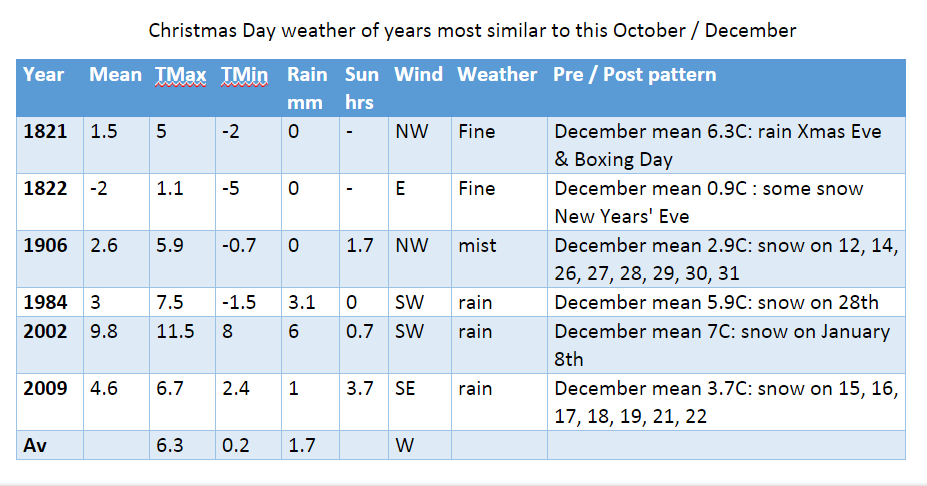
I firstly had a look at Christmas Day stats overall since 1840. The most common group of maxima in the series is 8.1C and above. This occurred 69 times or 40%. I then had a look at the years that most closely follow this October and November. None of the years saw a white Christmas, however it is interesting to note that five out of the six years saw some snow during the month. Snow often falls before and after Christmas. Why that is no-one knows.
So my guess for the weather on Christmas Day this year is for a maximum temperature of 6C after an overnight low of around 0C. With a little rain likely I suppose there is a chance of at least something sleety falling though I’d be surprised if, on Christmas Day morning, we pull back the curtains on a wintry Dickensian scene.
* The definition of a white Christmas used most widely – notably by the bookies – is for a single snowflake, even if it lands in the midst of heavy rain, to be observed falling in the 24 hours of 25 December at a specified location recognised by the Met Office.
** On average, snow or sleet falls in the UK 5 days in December, compared with 7.6 days in January, 6.8 days in February and 6 days in March. White Christmases were more frequent in the 18th and 19th centuries, even more so before the change of calendar in 1752, which effectively brought Christmas back by 12 days. Climate change has also brought higher average temperatures over land and sea and this generally reduces the chances of a white Christmas.


You must be logged in to post a comment.