
Lots of hype regarding winter at the moment with contradictory model output being released almost daily.
My early take on this is based on the current state of the El Nino Southern Oscillation (ENSO) index which is currently -0.6 and trending more negative (La Nina).
Using analogues from previous events would suggest that the coming winter in the south-east of England will be broadly average in terms of mean temperature and wetter than average.
Looking more closely at each year suggests the following.
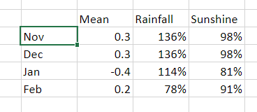
Further scrutiny of the local statistics suggest that the mean temperature for November could be lower than average, some 1.7C below average with rainfall around 20 per cent below average.
I should be noted, however, that in the years that were most similar to this September and October (1958, 1961, 1967, 2001, 2005, 2019) the ENSO index was much closer to neutral than it is now. In other words what happens next month could be vastly different to what happened in those years.
Years prior to those mentioned above add intrigue as ENSO statistics are not available.
1802 (cold January 1803), 1849 (severe January 1850 with ice in the Thames) 1862, 1865 (heavy snow southern England 10/11 January) 1874 (notable December storm)
Obviously a lot can change atmospherically in the next few weeks; this is an early take on my usual winter forecast which will be released on December 1st.

You must be logged in to post a comment.