The crux of the article is that certain weather types can repeat at the same time of year with one having a 100 per cent probability!
The Christmas storm singularity occurs in 84 per cent of years.
While 84 per cent certainly doesn’t mean ‘nailed on’, in the current set up of models being evenly spread between settled and stormy it can be safely guessed at this range that there will be unsettled weather around on the 25th. Whether it will affect the whole country remains uncertain.
The last big snorter of a Christmas storm I can remember in London was 2013. The entry for the 23rd into the 24th reads.
“Cloudy and breezy start grew steadily duller with rain just before noon. Rain grew heavier with some really strong gusts into evening culminating at 2am. Cloud at one point was 10kms thick. Three deaths related to weather.”
There was chaos nationwide with flooding and power cuts.
It’s that time of year again! With the midnight run of this model bringing the start of the 25th into range the prognosis for the big day is a rare white one – with snow likely almost anywhere.
But 15 days is an eternity in modelling so we can take this with a council depot load of salt.
It’s often not until 10 days out that models will start to get a firm grip on what the weather will be like on Christmas day.
My guess at this range is a quiet one with fog and frost and a high of 6C in London.
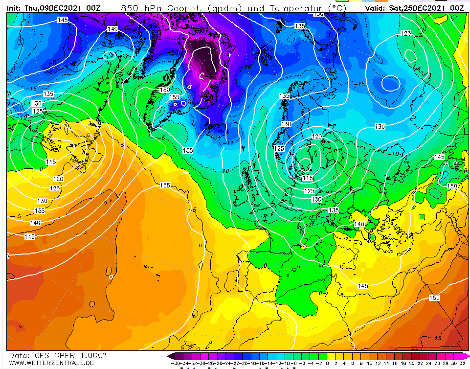
Friday, December 10th
24hrs on and, interestingly, the pattern hasn’t completely flipped to something opposite to above…
Saturday, December 11th
The high is more centrally located over the UK with proper cold air from eastern Switzerland eastwards. Cold, calm with frost and fog in London.
Sunday 12th December
Little change though any colder air is even further east. A Eurotrash high with declining air quality.
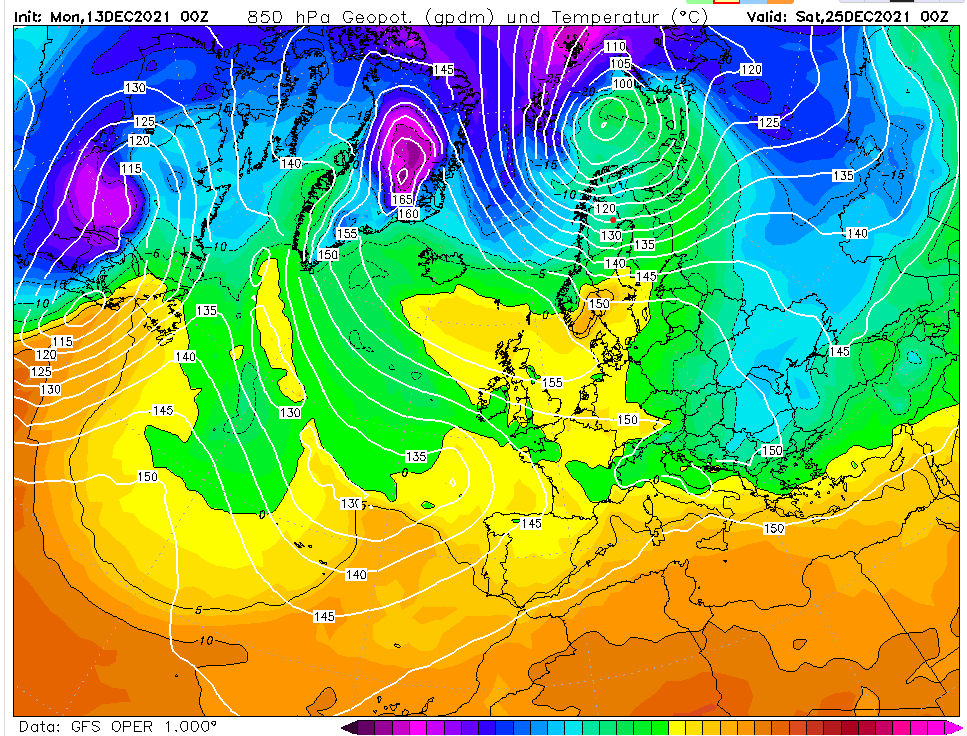
Monday 13th December
The models are in a state of flux, more so than usual by the looks of it. No change on my thoughts though.
Tuesday 14th December
Another slack flow with any true, cold air well to the east. My guess remains a dull and cold Christmas day after a slight morning frost.
Wednesday 15th December
Within the much more reliable 10-day range now and the GFS is throwing out quite an odd looking chart. It shows a mass of cold air just to our east, the start of a cold spell that takes us up to New Year’s Eve.
Thursday 16th December
My thoughts on Christmas day still remain the same as they were days ago. Cold, calm with a high of 5C. Beyond that GFS is hinting the Atlantic floodgates will open. I suspect it is jumping the gun by a couple of days and we’ll see a couple of cold days, the 27th being notably cold?
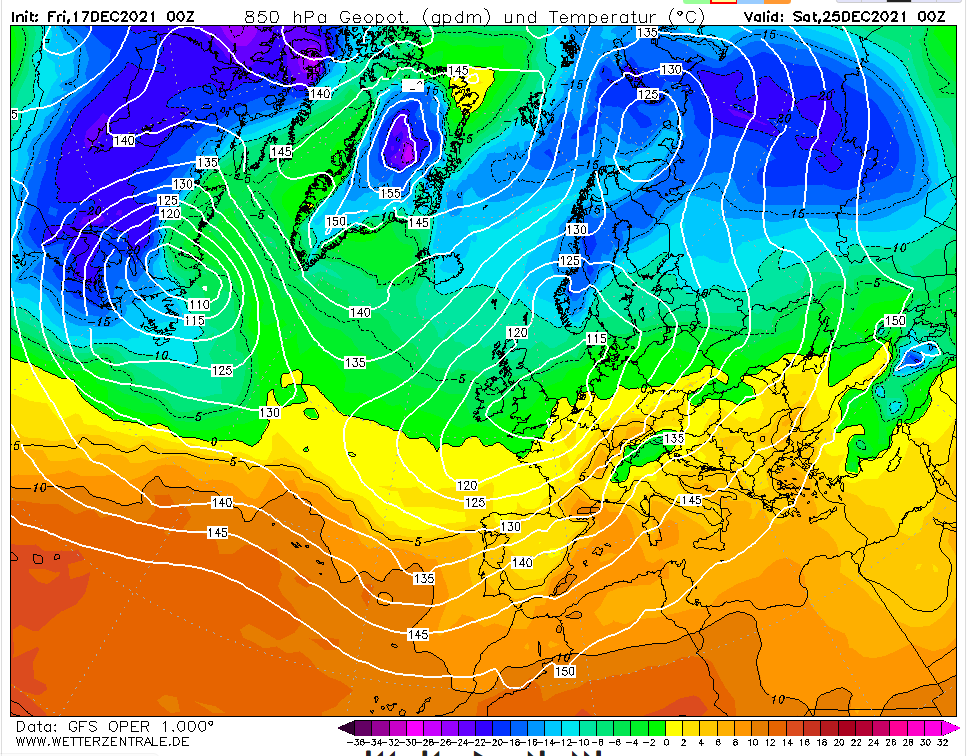
Friday 17th December
The GFS having another hiccup overnight. The situation at 0z hours probably 5C and cloudy in London. But it’s a deteriorating situation with 850mb temps plunging from the north – the conditions that could bring being consistent with the title of this blog. But I’d pay little notice to output like this until it is 48-72 hours away.
Saturday 18th December
A classic battleground scenario on the midnight operational. An even spread on ensembles, too. My hunch is that the high pressure will survive long enough for a quiet Christmas day. After that?
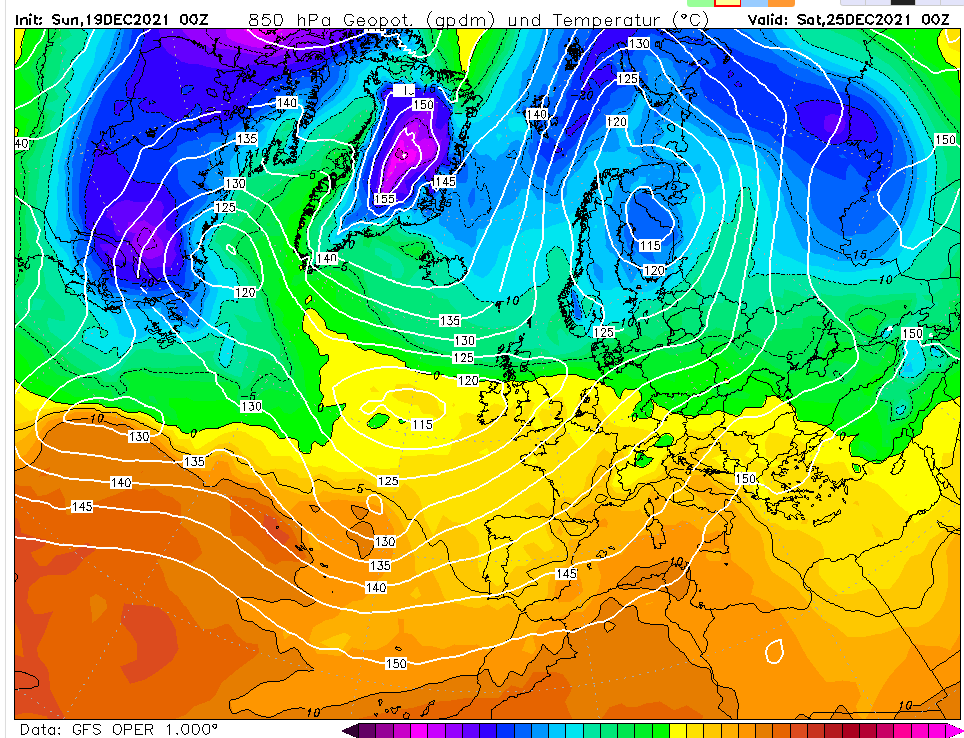
Sunday 19th December
GFS wants to bring 11C, outbreaks of rain this morning…
This winter is most likely to be on the colder side of average with near normal rainfall.
While the modelled prognosis for the first half of December looks unsettled with an Atlantic influence evolving from the current chilly NW’ly to a mild SW’ly, local analogues of the climate of London suggest the season could be a bit of a rollercoaster with spells of wet, windy and mild weather alternating with dry, calm and cold.
A large factor to consider this winter is the presence of a slight La Nina that is forecast to evolve cooler.
Given the uncertainties involved with the influence of ENSO I’ve decided to stick with analogues found in local data that stretches back to 1797.
Overall then the probabilities for the next 90 days are.
Mean
Probability
Rainfall
Probability
Mild (>5.9C)
14%
Wet (>178mm)
19%
Average (5.1C – 5.9C)
38%
Average (107-177mm)
62%
Cold (<5.1C)
48%
Dry (>107mm)
19%
The above table doesn’t reveal a great deal in that extremes can be hidden in a month or season that finishes broadly average. So I decided to look closer at the winters that were revealed in the analogues.
December
The first month, as already mentioned, looks like it will be on the mild side with possibly a notable storm off the Atlantic before things calm down over Christmas – the period between Boxing Day and New Year’s Eve possibly presenting the best chance of any lying snow in this region.
The below graphs are a smoothed representation of the years revealed in the analogues most similar to this autumn.
What is probably most interesting is that the analogues that shared a similar ENSO / La Nina index to this autumn tended to ‘turbo charge’ any yo-yoing in the weather type, be that super-mild or abnormal cold.
December probabilties for maxima: Mild: 48% Average: 19% Cold: 33%
And precipitation. Wet: 33% Average: 29% Dry: 38%
So, the month overall will be mild and slightly dry
January
The first month of 2022 probably represents this region’s best chance of lying snow this winter. A mild start perhaps with a falling off of temperatures in the final third of the month and a cold spell of a week or so. As with December the influence of La Nina could tend to boost the swings in the pattern.
January probabilties for maxima: Mild: 33% Average: 10% Cold: 57%
And precipitation. Wet: 19% Average: 43% Dry: 38%
Greatest chances for January, then, are cold with average precipitation.
February
The second month may see a slight return of the cold spell in January before temperatures recover for a mild and wet spell in the second half.
February probabilities for maxima. Mild: 33% Average: 15% Cold: 52%
And precipitation. Wet: 38% Average: 38% Dry: 24%
The stats suggest on the cold side overall with average to above average rainfall. Perhaps the depth of the cold skewing any very mild second half of the month?
The extremes that no-one can forecast
As well as the very mild winter of 1989/90 the analogues also revealed the very cold winter of 1978/79. There were others but their occurence makes the probability of a repeat at either extreme at less than 10 per cent.


You must be logged in to post a comment.