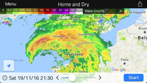
Compiling a list of sunless, rainy days revealed some interesting spells of wet weather – the most miserable runs of June days in the capital since 1959.
First up was a three-day spell starting on June 25, 1974. Some 34.3mm of rain was recorded.
Next was a three-day spell starting on June 23, 1991. Some 26.3mm of rain was recorded.
Another three-day spell started on June 25, 1997. Some 36.2mm of rain was recorded.
Finally, and most recently, a two-day spell this month that began on June 17th. Some 28mm of rain was recorded.
The above spells all happened around the date of the ‘June monsoon’ singularity which has a probability of 77 per cent. Though the fact that these occurred 47 years, 30 years and 24 years ago shows that these extreme cases happen a lot less than three years in every four the singularity would suggest.
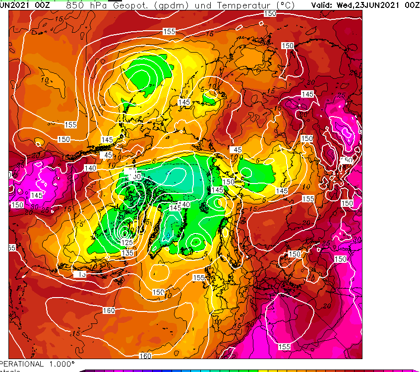
Comparing the current Northern Hemisphere pattern with 1974 suggests that while there’s just as much heat around at 850mb as there was 47 years ago, including an extreme heatwave over some Nordic countries, the air above Greenland appears colder.
The weather of late has been in stark contrast to the mostly dry, sunny (if a bit chilly) spring many enjoyed. Indeed the first half of June saw more of the same and, locally, was the warmest start to the first meteorological summer month since at least 1959.
My memory of summers years ago was that it was often hot and sunny but I also remember countless days of staring out the window for hours waiting for relentless rain to let up.
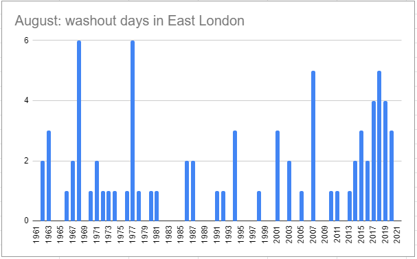
Looking back at sunshine stats to 1959 there has been over 4,400 days where no sun was recorded, roughly a one in five chance of a totally cloudy day.
Considering the months where the absence of sun is most noticed, May to October inclusive, the probability decreases to just under one in ten.
To decant these to ‘washout days’ I’ve only included those sunless days that were also ‘wet days’ where 1mm or more of rain was recorded. The probability further decreases to just under one in twenty.
All very interesting but were there more washout days decades ago or is the memory playing tricks?
Looking overall shows an increase since 2013. Out of all the months the most notable change has been August.
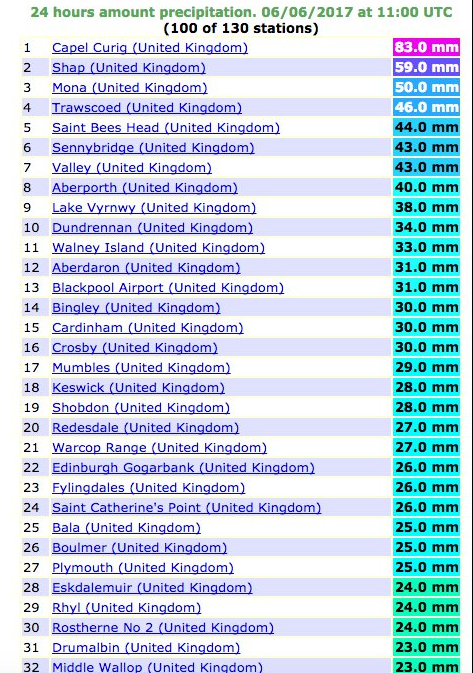
July 2017 was the wettest since 1960. Some 92.3mm of rain were recorded which is 212 per cent of the 1981-2010 average.
Although the opening third of the month saw a continuation of the June heatwave temperatures gradually returned to normal values to leave the mean for the month at 19.2C, that’s 0.7C above average.
With all the rain sunshine totals were down. Some 167 hours were recorded, that’s 87% of average.
Though the rainfall total was impressive it is well short of the record of 164.2mm set in 1834, and is only 35th in the list going back to 1797.
Summary for July 2017
Temperature (°C):
Mean (1 minute) 18.9
Mean (min+max) 19.2
Mean Minimum 14.7
Mean Maximum 23.7
Minimum 9.4 day 12
Maximum 30.5 day 07
Highest Minimum 18.3 day 06
Lowest Maximum 19.0 day 24
Air frosts 0
Rainfall (mm):
Total for month 92.3
Wettest day 30.8 day 11
High rain rate 56.4 day 29
Rain days 10
Dry days 21
Wind (mph):
Highest Gust 17.4 day 27
Average Speed 2.9
Wind Run 2163.5 miles
Gale days 0
Pressure (mb):
Maximum 1024.2 day 16
Minimum 996.8 day 31
Total hours of sunshine 167
In terms of the rest of the summer a look at the ECMWF control run out to 10 days suggests an unsettled start to August with the jetstream centred right over the top of the UK. Things may improve as the Azores high attempts to exert more influence – so perhaps more in the way of sunshine than of late. In terms of heatwaves it is impossible to tell at this range.
Here follows the full weather diary for July. To view full stats follow this link:http://1drv.ms/1kiTuzv
1st: Cloudy but with sunny spells developing, these growing longer in length by evening.
2nd: Sunny with just a few light cumulus.
3rd: Sunny start though with plenty of cloud around, this tending to thicken after lunch with odd spot of rain.
4th: Sunny and very warm early then tended to cloud over before sun returned in the late afternoon and evening. Some very unstable low to mid level cloud.
5th: Sunny with just a few cirro-cumulus. Feeling very warm with cloud bubbling up in the evening, however forecast storms failed to materialise.
6th: Sunny with cirrus and dotted cumulus. This tended to thicken late morning though sun stayed out and became hot and humid.
7th: Sunny with lots of high-level cirrus and cumulus most of the day.
8th: Bright but mostly cloudy start, the cloud tending to vary through the day. Sunny after 4pm. Warm overnight.
9th: Bright but mostly cloudy start, the cloud tending to break and vary through the day.
10th: A mostly sunny morning and lunchtime until 2pm when it clouded over.
11th: Cloudy with some bright breaks at first. Cloud thickening with rain by noon, this falling sporadically before getting going after 5pm and stopping by 3am.
12th: Cloudy, damp and close start.
13th: Sunny with variable cloud until noon when there were just bright spells.
14th: Cloudy but with a few breaks around mid morning. Turning cloudy again before sunny spells in the evening.
15th: Cloudy with some sporadic rain as warm front blew through and close. Very limited brightness.
16th: Cloudy with some bright spells. Feeling warm and humid.
17th:Sunny with just a few cirrus drifting around. Feeling hot, cloud thickened from the west in the late afternoon.
18th: Sunny with variable cirrus and cirro cumulus through the day. Feeling very warm. Storms began building with supercell to west of London and over Chilterns.
19th: Cloudy, dull start and very humid with heavy mist – the cloud tended to lift to give sunny spells in the afternoon.
20th: Drizzle after shower before obs time, then showers through to 1pm.
21st: Cloudy start but with sunny spells developing. Clouded over in evening with intermittent heavy rain at 11pm and through the early hours.
22nd: Cloudy but with sunny intervals developing around noon. Heavy showers developing with thunder at 2.30pm and 3.07pm.
23rd: Bright with variable cloud
24th: Cloudy with light, showery rain from northerly airstream that originated in the Med.
25th: Cloudy with light rain just after obs time.
26th: Cloudy with occasionally rain. Feeling warm and a late clearance. Breezy and chilly overnight.
27th: Cloudy but bright and sunny spells developing. A very heavy shower at 1pm.
28th: Bright start but clouding over.
29th: Sunny start with cloud increasing after noon to leave overcast before patchy rain moved in. This falling more heavily at 5pm before clearing to further showers. More rain overnight before a strong squall arrived at 2.45am and lasted an hour with further bursts of rain through the night – two claps of thunder and lightening during squall.
30th: Sunny with variable cloud through the day. Very warm in the sunshine
31st: Sunny with variable cloud throughout the day.
June 2017 has been a month of real contrasts. A thundery deluge on the 2nd was followed by conditions typically brought by the European monsoon.
24hr rainfall totals
Warm weather followed in the second week before a full-blown heatwave arrived bringing the hottest June spell since 1976.
The mean temperature for the month finished at 18.9C, that’s 2.8C above average. It was the second warmest June in a local record going back to 1797. Though it was only 0.4C cooler than 1976 it was also much wetter than that very dry month.
Though it appeared a wet month, over two-thirds of the recorded rain fell in two episodes.
Sunshine for the month was 202.3hrs, 114% of average.
In terms of the rest of the summer you would be forgiven for thinking that we have already had more than our fair share of good weather. One way of looking at it is to count the number of days the mercury rises above 25C with 10 hrs of sunshine. Since May that has happened on 13 occasions – far higher than anything in the past four years.
It will be interesting to see if July and August, normally the months where we get most of our summery weather are as good as June.
Summary for June 2017
Temperature (°C):
Mean (min+max) 18.9
Mean Minimum 13.8
Mean Maximum 23.9
Minimum 9.9 day 12
Maximum 31.5 day 21
Highest Minimum 21.1 day 21
Lowest Maximum 16.7 day 28
Air frosts 0
Rainfall (mm):
Total for month 71.1 (138.9%)
Wettest day 31.2 day 02
High rain rate 108.4 day 02
Rain days 8
Dry days 22
Wind (mph):
Highest Gust 27.3 day 05
Average Speed 3.5
Wind Run 2550.5 miles
Gale days 1
Pressure (mb):
Maximum 1025.0 day 16
Minimum 984.2 day 05
Total hours of sunshine 202.3
Here follows the full weather diary for June. To view full stats follow this link:http://1drv.ms/1kiTuzv
1st: Sunny with scattered cumulus through the morning, the cloud thicker during the day.
2nd: Cloudy start though brightening up with long sunny spells. Cloud bubbled up and a heavy thunderstorm moved in at 3.15pm and lasted an hour. Sunny again by 6pm.
3rd: Bright start with decreasing cloud.
4th: Sunny start though cloud bubbling up late morning into early afternoon. Cloudy and breezy with a few spots of rain at dusk.
5th: Cloudy and very breezy start. Bright at times.
6th: Rain and very windy to start with gale force 9 in Channel. Rain lasted into the early afternoon before clearing to bright spells. Odd shower overnight but remained blustery with a few trees down. Flowering cherry fell at mum’s at 6.30pm.
7th: Sunny with long sunny spells. An area of rain after dark then overcast through the night.
8th: Cloudy and breezy, a shower at noon and some bright spells at 1pm.
9th: Sunny though breezy with lots of cloud. Spots of rain in the wind.
10th: Sunny and warm start with lots of sunshine. Very breezy.
11h: Sunny and feeling very humid but breezy. Alternating between very warm sunshine and cloud. Very brief few drops of rain at dusk then mostly cloudy night.
12th: Sunny periods throughout the day. Cloudier at times. Clear overnight with warm, sunny start.
13th: Sunny, clear start and feeling warm early.
14th: Sunny most of the day with odd cumulus. Very warm though turning a bit fresher overnight.
15th: Sunny morning though with more cloud than yesterday. A fresh breeze developing.
16th: Sunny with variable cloud. Warm.
17th: Sunny though lots of hazy cumulus.
18th: Sunny though much cloud amid the humidity. Felt airless with only limited breeze. Oppressive overnight.
19th: Sunny with cloud decreasing
20th: Bright start though cloud breaking at 11am to leave clear afternoon with just a couple of cumulus.
21st: Sunny and hot all day with patchy cirrus. Warmest June day since 1976 at Heathrow 33.9C. Warm overnight but more of a breeze. Sunny early.
22nd: Very brief rain shower at obs time then sunny intervals. Cooler but still humid. Very breezy overnight.
23rd: Long sunny spells with hazy cumulus. Although cooler still hot in the sunshine. Cooler overnight and breezy.
24th: Mostly cloudy though bright. A sharp shower in the evening.
25th: Bright though mostly cloudy. A couple of bursts of drizzle but then sunny spells late evening.
26th: Sunny with lots of cirrus, cirrocumlus and a fallstreak hole in the sky. Warm but low humidity.
27th Sunny start though sun becoming scarce. Patchy light rain at 10.30am and thunder then a heavy shower at 3.45pm. Rain in the evening that lasted into the early hours.
28th: Cloudy and very dull at times with very light drizzle. Humid.
29th: Cloudy though bright with some sunny intervals.
30th Sunny though with lots of cloud. Decreasing cloud in the afternoon and a pleasant evening.
December 2016 was the driest 12th month in over 80 years and the 5th driest in a record going back to 1797.
Christmas day was the second warmest on record in London
The total fall of 8.3mm is just 16 per cent of what normally falls in December, marginally more than December 1933. The mean temperature of 6.1C was 0.5C above average, though 4C colder than the record December last year.
There were 51hrs of sunshine, that’s 125 per cent of average.
The wettest day was on the 10th when 5.2mm of rain fell. The warmest day occurred on the 9th with 14.2C recorded. The lowest temperature occurred on the 28th when the spirit fell to -4C.
The sunniest days were on the 4th and 29th when seven hours of sunshine were recorded.
Air frosts: 8, Ground frosts: 14
Fog, frost and black ice all featured during December
Though January has started on the chilly side in the short term the weather will turn mild. Beyond that there is a suggestion that the weather could turn on the colder side of average with some models suggesting a cold snap with snow around mid-month.
My usual method of prediction to the end of the month has been scotched by the very dry December. The only years that were similar were both far colder than last month – the usual pattern of a dry month being cold or very cold was broken.
With the unprecedented warmth at the North Pole, last year’s odd behaviour of the QBO and a weak polar vortex we are in unprecedented territory in terms of what could happen later in January. My hunch, though, suggests the month will end up average to rather cold with little precipitation. Any cold spell with probably be the short-lived variety with a couple of inches of snow that lasts three days.
So, to sum up, we’re looking at a mean of 4.4C, rainfall: 55mm, sunshine: 39hrs.
In view of the above my forecast last month was very poor: predicted mean 4.4C (result 6.1C). Rainfall: 55mm (result 8mm). Sunshine: 39hrs (result 51hrs)
I have also published a winter forecast covering the London area that you can find here.
Here follows the full weather diary for December…Full stats for the month here:http://1drv.ms/1rSfT7Y
1st: Sunny start though the frost lifted readily into low cloud and mist to leave a chilly afternoon.
2nd: Cloudy, quiet and cool weather all day.
3rd: Cloudy and quiet all day. Feeling cold.
4th: Sunny , frosty start. Quickly warming up to leave sunny, cloudless afternoon.
5th: Sunny start, then patchy cloud – this thickening before becoming foggy overnight.
6th: Misty start after fog overnight. Cloudy most of the day though there was a brief clearance around midday.
7th: Cloudy most of the day though there was occasional brightness.
8th: Dull day though with a little limited brightness early afternoon.
9th: Cloudy but wth more brightness than yesterday. Very mild. Cloud thickened with light rain around 11am. This gradually grew heavier as the day progressed and was moderate overnight.
10th: Bright start and feeling mild, then cloudier and damp.
11th: Cloudy and dull all day.
12th: Dull all day with light rain early and late. Clearer spells overnight but overcast again by dawn.
13th: Dull with bits and pieces of drizzle up to 11.20am.
14th: Bright start with lots of cirrus and altocumulus – this gradually cleared to leave a warm and pleasant afternoon.
15th: Dull and cloudy with limited brightness.
16th: Dull and cloudy start.
17th: Foggy and dull all day.
18th: Misty start with fog above 90m on cycle ride. Then dull and grey all day. Mild.
19th: Dull and cloudy all day – some spots of drizzle.
2oth: Sunny start but clouded over late morning. Cloudy thereafter with some drizzle overnight.
21st: Cloudy start then sunny. Cloud returned and turned dull and dreary in the afternoon with odd drizzle.
22nd: Bright, misty start
23rd: Cloudy start with breeze beginning to build as a result of Storm Barbera.
24th: Cloudy and dull all day. Very mild. Temp increasing overnight with approach of warm front .
25th: Cloudy, breezy start. Remained dull all day though brightness was seen over the Thames and North Downs, disrupting the SW’ly flow.
26th: Sunny, hazy start and turning colder.
27th: Sunny, frosty start, the air pressure record of 2012 has been broken.
28th: Foggy start, the fog persisting to late morning before sun broke through leaving a chilly afternoon. Frost returned quickly after dark, a clear night.
29th: Sunny and very cold and frosty start. Frost returning after dark with fog forming in the early hours.
30th: Foggy and dull all day, the fog thickening up at nightfall. Approaching cloud lifted the fog and temperature.
31st: Dull and overcast to start – this sticking around all day.
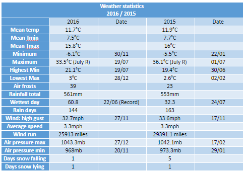
This year finished as the 14th warmest on record – some 0.5C warmer than the 1981-2010 average – though 0.2C cooler than 2015.
Only four months of 2016 were below average temperature-wise
Six months of 2016 were roughly average – the means being within +/-0.7 every month, bringing the mean temperature to 11.7C.
Rainfall was less remarkable with the year being a little drier than average. The total of 561mm (93% of 1981-2010 average) puts it as the 122nd wettest since 1797, just 8mm wetter than 2015.
It was also a slightly duller than average year with 1,390 hours of sunshine recorded. That’s 93 per cent of average, the 92nd sunniest since 1881 – the least amount of sunshine for 12 years.
November 2016 was the sunniest in a record going back to 1881. Some 91 hours were recorded, 156 per cent above average and a complete contrast to last November which was the dullest for 47 years.
The temperature in the early hours of the 30th fell to -6.1C, colder than any night last winter and the coldest since January 2013
The mean temperature for the month finished 6.4C, that’s 1.5C below the 1981-2010 average ; 4C cooler than last year and the coldest November since 2010. The warmest day occurred on the 15th with 15.9C recorded. The first air frosts of autumn were recorded. The lowest temperature occurred on the 29th when the spirit fell to -6.1C.
Rainfall was 135 per cent of average with 80.1mm recorded. The wettest day was on the 19th when 23.5mm of rain fell.
The sunniest days were on the 2nd, 13th and 25th when eight hours of sunshine were recorded.
Air frosts: 4, Ground frosts: 19
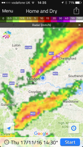
The dolphin-shape of this radar image shows Storm Angus before it hit the south coast. The system stayed far enough south of us not to cause any damage in London
What has December got in store weatherwise? The models suggest the high pressure that has been anchored over us, bringing cold nights, will pull away to the continent. This will allow an ever milder but mostly dry source of air off the Atlantic through to mid month. Days will grow milder while frost and fog will feature less at night.
Beyond the grasp of the models my long range outlook method suggests an coldmonth is most likely at 43 per cent probability. Average comes in at 29 per cent probability while rather mild and rather cold are both 14 per cent probabilities.
Rainfall looks finely balanced. Wetter and dryer than average both come in at 43% probability while average is 14 per cent. Given the influence of high pressure at the beginning of the month I’m inclined to think it will be a drier than average month.
So, to sum up, we’re looking at a mean of 4.4C, rainfall: 55mm, sunshine: 39hrs.
My forecast last month was good: predicted mean 6.8C (result 6.4C). Rainfall: 55mm (result 80mm). Sunshine was way off, however – predicted total: 41hrs (result 91hrs)
I have also published a winter forecast covering the London area that you can find here.
Here follows the full weather diary for November…Full stats for the month here:http://1drv.ms/1rSfT7Y
1st: Cloudy and mild all day. Patchy drizzle at times.
2nd: Sunny, cold start after first ground frost of the autumn.
3rd: Sunny, cold start with cirrostratus and cumulus drifting around. Cloud thickened through the afternoon with some light rain around 9pm.
4th: Cloudy, dull start up to 11am. Rain pushed in and lasted for much of afternoon, clearing in evening.
5th: Cloudy, cold and damp start. Some brightness though with a cold wind.
6th: Sunny, cold start, tending to cloud in. Rain after 3pm. Feeling cold but too windy for a frost overnight.
7th: Sunny, cold and very breezy to start, the cloud tending to fill in through the day. Clearer overnight though too much cloud and occasional air prevented an air frost.
8th: Sunny and cold start. Cloud thickened during the day to bring rain after dark at 8pm that then fell through the night – the biggest fall since Brexit day.
9th: Light rain slowly clearing to cloud.
1oth: Cloudy start with light rain showers around 10.30am then cloudy. Some sunny intervals in the afternoon. Milder.
11th: Bright start with cloud decreasing through the morning to leave a pleasant and clear afternoon.
12th: Miserable and rainy to start, this lasting past 11.15am. Drizzle thereafter into 6pm.
13th: Sunny start though cloud tended to fill in through the day. Damp overnight with patchy drizzle.
14th: Cloudy and damp start with some breeze. Brief brightness at noon but patchy drizzle moved in around 4pm.
15th: Cloudy and miserable though very mild.
16th: Sunny start and very mild though cloud tended to fill in during the day making the sunshine milky.
17th: Bright, breezy start, the breeze increasing until a squall blew through at 2.40pm then sunny spells.
18th: Bright start with milky sunshine then tending to cloud over. Feeling cold.
19th: Bright sunshine though cold to start. Patchy altocumulus developed through the day, leaving it to become bright, the strength of the sun diminishing. Rain started around 6pm and fell through night with varying intensity.
20th: Dull and cloudy start with rain returning at 10am. Cloudy afternoon with rain returning late evening and through the night, some heavier bursts.
21st: Cloudy with showers past noon. Heavier showers moved in mid afternoon and fell into the evening.
22nd: Cloudy with a few very light showers around. Breezy.
23rd: Cloudy and breezy. Feeling mild.
24th: Cloudy and mostly dull with brief brightness at noon.
25th: Sunny with just a few cumulus around.
26th: Sunny start but low cloud blotted out the sun around midday then cloudy and cool.
27th: Cloudy and mild.
28th Sunny all day with just a few cumulus floating around.
29th: Sunny all day with frost persisting on grass in shade.
30th: Sunny and very frosty start. Frost persisting on the grass all day with a very cold start to the night. A veil of cloud crossed the region late evening, lifting the temperature above freezing, before clearing before dawn
October 2016 was yet another dry month, a pattern that has emerged since the middle of June. Just 52 per cent of the October average was recorded.
October saw many pleasantly sunny days
The monthly mean finished 11.5C, 0.3C above average and ending a three-month run of warm temperatures.
Some 105 hours of sunshine were recorded, 98 per cent of average
Air frosts: 0, Ground frosts: 0
So what has November got in store weatherwise? The models on the 1st suggest an anticyclone anchored to our west over the Atlantic will bring a regime of, at times, chilly northerly winds and the potential for rainfall, much probably in the form of showers, driven by low pressure in the North Sea. Where skies clear at night there will be potential for the first air frosts of the autumn.
Beyond the grasp of the models my long range outlook method suggests an average or cold month is most likely: average and cold are both 30 per cent probability. Rather cold and severe are both 20%! There appears no chance of anything mild.
Rainfall appears that it will be skewed toward something above average at 40 per cent, though average and below average are both 30 per cent.
Sunshine looks average at 57 per cent probability.
So, to sum up, we’re looking at a mean of 6.8C, rainfall: 55mm, sunshine: 41hrs.
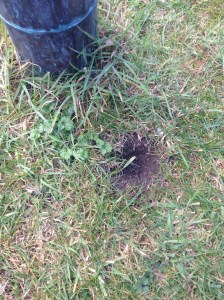
Numerous holes dug by squirrels appeared in October. The squirrels have no more an idea than we do whether winter will be cold
Here follows the full weather diary for October…Full stats for the month here:http://1drv.ms/1rSfT7Y
1st: Rainy start with showery bursts to 11.25am then through afternoon mostly cloudy.
2nd: Sunny but chilly, feeling very autumnal. Clearing into the evening with a cold night to follow.
3rd: Sunny, gin clear all day until 2.08pm.
4th: Another sunny albeit slightly hazy start then patchy cumulus. Warm in the sunshine even with a easterly breeze.
5th: Sunny start though breezy and with quite a few cumulus around. Cloud streets observed at 10.30am, the cloud tending to decrease and completely melt away by 4pm.
6th: Sunny start but with much cloudier spells at times. Warm in the shelter.
7th: Cloudy all day, the cloud thick enough at lunch time for drizzle that damped the ground.
8th: Cloudy with bursts of light drizzle in the morning, some brightness. A heavy shower at 2pm was brief then cloudy. Clear and cold overnight.
9th: Sunny until 2pm with patchy cumulus – a really glorious morning. Sunny spells in afternoon with cold night to follow.
10th: Sunny with just patchy cirrus first thing. Thick patches of alto-cumulus drifted across from time to time. Cold overnight.
11th: Sunny with patchy cumulus which melted away through the day. Showers after dark, one at 2330z.
12th: Cloudy and damp start. Short, sharp shower at noon then mostly cloudy.
13th: Rainy , wet start thanks to a streamer of moderate to heavy showers.
14th: Cloudy am but with lots of sunshine mid-morning before clouding over again though staying bright.
15th: Bright start but with lots of cloud pushing in and light burst of drizzle at noon. Cloud thickened before rain moved in after 5pm and fell intermittently through the night.
16th: Damp start as the remnants of the overnight rain cleared away, then becoming brighter at 11.15am. Sunny spells for a time before turning cloudier with some very sharp showers on yet another convergence line.
17th: Cloudy start but soon brightening up with some pleasant sunny spells. Heavy burst of rainfall at 5.30pm with more showers at midnight and early hours.
18th: Cloudy though quickly turning bright and breezy with long sunny spells after clearance of the cold front.
19th: Bright start though more cloud around than sun all day. Feeling colder than of late.
20th: Bright and breezy with variable cloud and sunny spells. A short shower at 2pm damped the ground. Clear spells overnight made it chilly. A shower at 9.30am.
21st: Cloudy and chily start.
22nd: Cloudy and cold start, brief clearance at 11am then sunny spells.
23rd: Sunny and clear to start though cold. Sunny spells into the afternoon. Cloudy overnight.
24th: Cloudy and cool during the day and overnight.
25th: Dull and cloudy with only limited brightness. Clear early evening with temp falling before it turned misty. Cloud pushed in raising the temperature.
26th: Cloudy start and turning very dull before bright spells spread in at noon.
27th: Cloudy though getting brighter through the morning with a brief clearance at noon, then bright and sunny intervals.
28th: Sunny and very mild to start. Sunny spells through the day.
29th: Cloudy start with bright intervals after midday. Clear spells after dark with fog forming after 11pm which gave a foggy start.
30th: Foggy start then cloudy and miserable.
31st: Fog to start then clearing at 11am. Gorgeous sunny day thereafter.
Last month was the second warmest September in a local record going back to 1797! The monthly mean finished 17.8C, 2.4C above average. Despite being an ‘autumn’ month September was actually a full degree warmer than June!
September 2016 was the second warmest in a local record back to 1797, though we’re talking by fewer than tenths of a degree.
The hottest September day since 1959 was recorded on the 13th when 33.1C was reached, the sixth equal hottest in the local daily record back to 1848.
The month also saw the warmest minimum recorded since 1959 when the mercury failed to fall below 18.7C on the 6th.
It was another very dry month, the third much drier than average month in a row: just 27.7mm fell, 24 per cent of average, making it the driest September since since 2007 and the 12th driest in the local record.
Like August, the month only falls down in terms of impressiveness when sunshine hours are considered. Some 119 hours were recorded, that’s 85 per cent of average, making it the dullest September for 15 years.
Air frosts: 0, Ground frosts: 0
So what has September got in store weatherwise? The models on the 1st suggest that a large Scandinavian high will become established to our NE bringing lots of settled weather and showers on coasts. There’s obviously the chance of trough disruption as the month progresses if the anticyclone’s influence declines.
Beyond the grasp of the models my usual long range outlook method falls down this month due to September’s warmth and dryness – there is nothing within +/- 10% of September’s statistics. I would guess, however, that we are looking at another drier than average month with frost becoming a risk as the month progresses where skies clear. There is also the chance of more pleasant autumn days where skies are clear during the day.
My September outlook for temperature was poor. I predicted a mean of 15.3C (outcome: 17.8C). It was much, much drier than I thought: 300mm (outcome: 27.7mm). Sunshine was poor: 140 hours (outcome: 119 hours).
Here follows the full weather diary for September…Full stats for the month here:http://1drv.ms/1rSfT7Y
1st: Sunny start but cloud gradually increased until it was overcast by 6pm. Clear spells overnight but warmer than previous nights.
2nd: Cloudy though some brighter intervals.
3rd: Sunny start, cloud began to pile in at 12.30pm with rain arriving at 5.30pm, this fell through the evening with some showers in the early hours.
4th: Bright, breezy start but rapidly turning cloudy and dull. Some rain overnight.
5th: Light rain and dull to start – this quickly clearing to cloud by 3pm. Things remained cloudy with a muggy night.
6th: Cloudy, dull and muggy start after warmest September night on record. Another warm night though muggy.
7th: Cloudy to 11am though sun breaking through as drier air arrived. Feeling humid.
8th: Sunny start but with plenty of cumulus, this quickly decreasing to leave clear sky.
9th: Cloudy morning though sky seemed to periodically clear of low cumulus before becoming overcast and very breezy in the afternoon. Some rain overnight and just before obs time.
10th: Cloudy start with patchy light rain, this briefly turning heavy at 1pm before turning occasionally moderate. Dreadful afternoon after recently. Clearing overnight to leave a sunny start.
11th: A glorious sunny day with only the odd patch of cirrus.
12th: Bright start with some sunshine, clouding over with a few splodges of rain with warm front. Then sunny and very warm.
13th: Sunny start with a few cirrus and castalanus around. Breezy at times with the thermals. The warmest September day since 1959 and 6th equal warmest since 1848.
14th: Sunny start with a few cirrus. A few patches of alto-cumulus later. Very warm but not as hot as yesterday. Warm, pleasant evening. 15th: Sunny with a few wispy cumulus, clearing to hot sunshine. Some alto-cumulus developed at 2pm and towering cumulus could be seen in distance. Thunderstorms reporting to NW of London. Cloudy and warm overnight with eight peals of thunder in the early hours and heavy rain.
16th: Light to moderate rain through the morning, petering out at 1.30pm.
17th: Cloudy, cool and breezy all day, at times dull.
18th: Cloudy all day, a bit warmer than the previous two days.
19th: Cloudy start though with sun breaking through briefly at 11am until 1pm then cloudy again. Rain at 1am that didn’t last long enough to register.
20th: Cloudy and fairly calm – a nothing day with odd very light drizzle.
21st: Bright start with cloud breaking to long spells of sunshine before more cloud moved in. Warmer than of late.
22nd: Cloudy but sun broke through giving pleasant afternoon and cool overnight.
23rd: Sunny, gin clear and cold start. Just a few fair weather cumulus through the day.
24th: Sunny start with cloud decreasing. Very warm in sun but cloud and breeze built through the day. Overnight light rain between 6am and 9am.
25th: Bright start after overnight light rain.
26th: Bright start with a few cloud breaks here and there. Heavy shower at 12.15pm with further threat of rain but stayed dry.
27th: Bright start with signs of a cold front moving in from south then cloudy.
28th: Sunny start with patchy cirrus, this tending to thicken at lunchtime to turn mostly overcast with humidity increasing. Breeze also picked up with reappearance of sun mid afternoon. Cloudy, very mild and breezy rest of the day.
29th: Cold front and brief heavy rain swept in at 10.03am. Then intermittent falls until 11.23am.
30th: Sunny, gin-clear start, patchy cumulus bubbling up at 10.30am. Cloud grew thicker around 12 noon with brief shower at 1pm. Then sunny spells and cloudier periods. Another shower just after nightfall then clear. Cloud moved in after 2am with another shower. Early sunshine gave way to moderate showers around 9.45am.
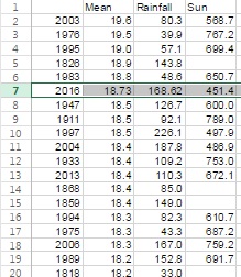
Summer 2016 turned out to be a very decent season overall, the mean temperature of 18.7C (1.1C above average) made it the sixth warmest summer since 1797.
While it wasn’t quite up there with the hot summers of 1976 and 2003 it still produced some notable records. The stormy beginning to June effectively ended with the Brexit vote, a period of 24 hours that coincided with the highest daily rainfall this area has seen since at least 1959.
The multi-cell thunderstorm in the early hours of June 23rd produced 60.8mm of rainfall, nearly half of the month’s total which became the third wettest June in a record going back to 1797. The high rainfall was in complete contrast to July and August and helped skew the overall figure: 168.6mm is 114 per cent over average summer rainfall.
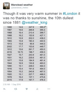
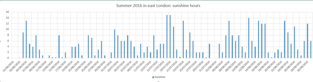
With so much rainfall overall sunshine was affected with only 451 hours recorded, just 80 per cent of what can be expected in an average summer.
July produced another record, this time the highest overnight minimum recorded since 1959. The minimum of 21.1C was recorded during the early hours of the 20th – coming hours after the hottest day of the year: 33.5C – the 14th hottest day on record.
The warm and very dry theme continued into the final month of summer with the warmest August for 12 years, the 10th warmest and 12th driest since 1797.
My summer forecast, when the monthly probabilities are considered, was broadly correct though I didn’t estimate correctly just how warm it would be.


 With so much rainfall overall sunshine was affected with only 451 hours recorded, just 80 per cent of what can be expected in an average summer.
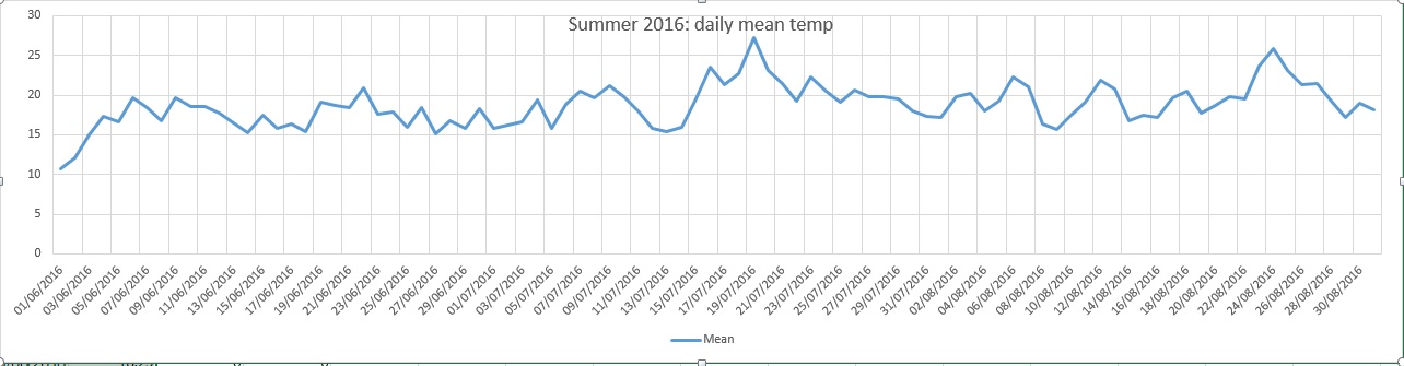


You must be logged in to post a comment.