Frost still lingers on my lawn as I write this winter forecast on the last day of the meteorological autumn. Last night’s minimum was -6.1C, the coldest night this year and, indeed, colder than any night last winter.
It would be very easy to get caught up in the hysteria that happens every November of what the winter will bring. Most of the hysteria comes from ‘coldies’, those folk that hope every winter will be the coldest and snowiest on record. I count myself among them.

But, despite hints from BBC weather forecasters that something maybe afoot in terms of something colder than usual from mid-December, years of disappointment have taught me to just take winter as it comes. Meteorological models this morning look anomalously warm for the first half of December, the UK being on the warm side of an anticyclone centred over France – the theme of so many winters I can remember.
The current phases of ENSO and QBO suggest that their influence on our winter this year will be far less marked than last year. Looking at teleconnections with a slight La Nina and the current QBO cycle have revealed winters that were fairly uninspiring though by no means write-offs for snow, two examples in the case of QBO being 1985/86 and 1990/91 – both had very cold Februaries.
Before I got too bogged down with trying to find patterns here I decided to move on to my more traditional pattern-matching.
Before I trawled through the figures my initial gut reaction to this winter was that it would be the coldest for at least four years – a not-too-difficult feat giving the mildness of the last three winters which saw very little in the way of snow.
 The overall mean temperature for December, January and February came out at as 4.2C – 1.2C colder than the 1981-2010 average, with average precipitation.
A rather cold winter, over three months doesn’t tell you much. A very mild and stormy December could mask a dry and notably cold February. This makes it worth looking at the individual months of each winter.


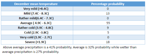
There is a lot of spread in the above tables. Considering them altogether I would guess winter will unfold in the following way:
December to start mild, possibly becoming very mild, before beginning to turn very cold mid-month. This pattern will persist, with varying intensity through into January which could also be very cold. Milder conditions to follow in February though this will probably end a fairly average month and drier after a slightly wetter than average December and average January.
As well as my method of using rainfall and temperature I also considered other methods. One was Russian research that states that the weather pattern in the winter will be the opposite to the weather on September 17th and November 7th. This autumn September 17th was N’ly and November 7th was NNW’ly. So, this would suggest a continental flow from S and SSE.
You can read the method of how I reached my conclusion here.

You must be logged in to post a comment.