February 2015: average

feb3rd snow
A snowfall on the 3rd just about covered the ground for a few hours, though was barely enough to make a snowball

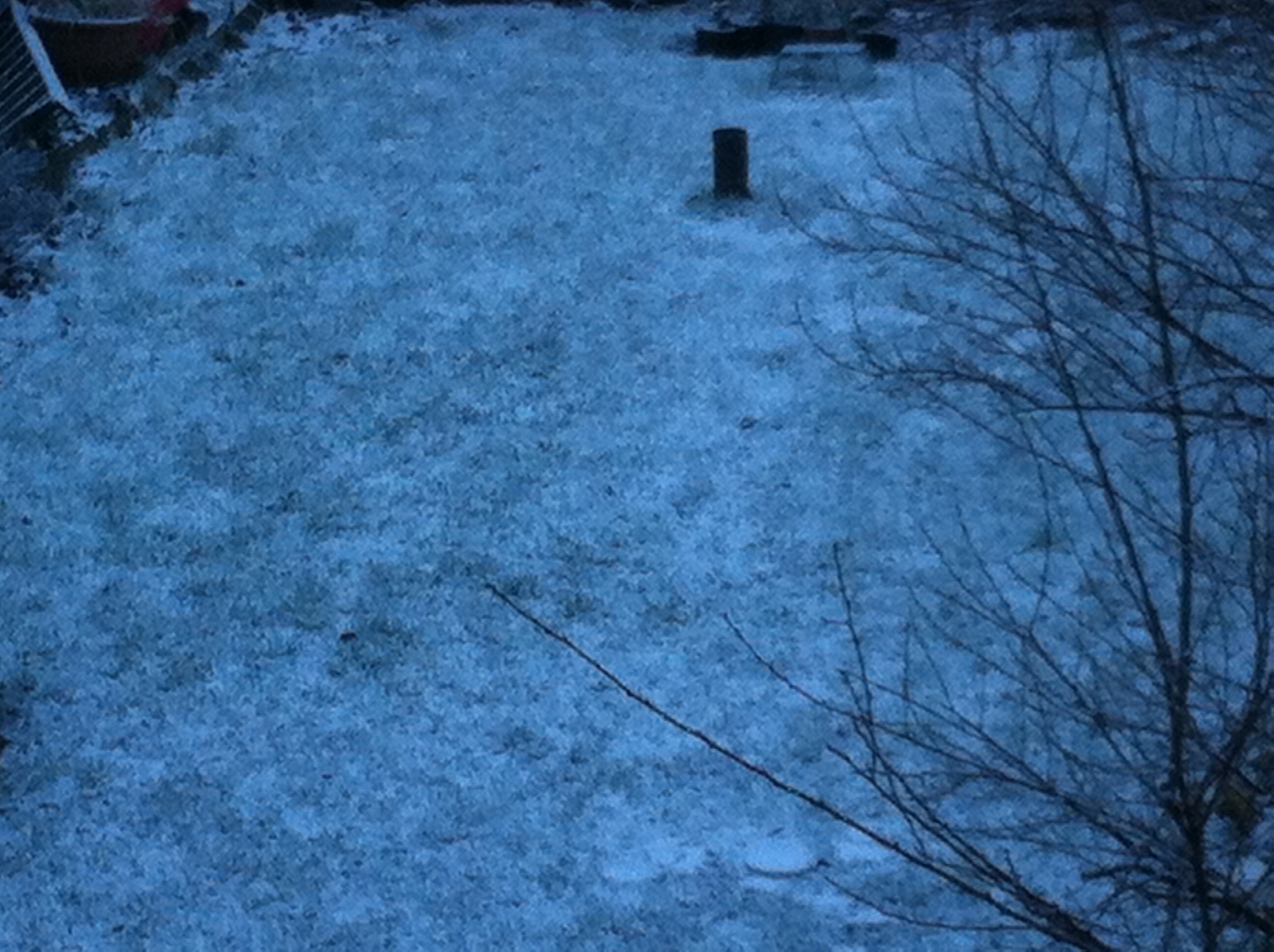
Though it only lasted a couple of hours this February saw the first lying snow in nearly two years. The 1cm depth at 9am on 3rd, however, is nothing much to write home about by average winter standards.

Mean temperature for the month was 4.9C, 0.4C below the 1981-2010 mean, 2.5C cooler than the mild and stormy February of last year. Rainfall of 43.6mm was 111% of average.

There were 73.6 hours of sunshine recorded in this area which is precisely 100% of what we can expect to see during an average February. The wettest day occurred on the 19th with 8.7mm. Snow fell on 3 days, hail on 2. Air frosts: 4 Ground frosts: 19

So what has March got in store weatherwise? The models this morning (March 1st) suggest a taste of spring – the recent cold and showery regime being replaced by quiet, anticyclonic weather. Output suggests variable cloud cover with a mild SW wind. Obviously sunny days will see quite respectable temperatures though any clear nights will see frost and mist developing.

View from top of Ditchling Beacon in Sussex during a  half-term walk
View from top of Ditchling Beacon in Sussex during a half-term walk

Beyond that the outlook is uncertain. Using a similar method to my Christmas forecast, which was correct at 25 days ahead and my January and February outlooks, I’ve had a look back in the archives to see if there is any precedent in the pattern we’ve had this February.

There appears no chance of a very mild March. The strongest signal (67%) is for a cold March. The strongest signal for precipitation is for average to slightly below (83%). Sunshine, no overall signal, so my guess is average.

Though we are now out of the meteorological winter there is still a risk of snow. Any falls, however, would be thin and transitory because of the strength of the sun now.

Full stats for the month here: http://1drv.ms/1rSfT7Y

Here follows the full weather diary for February…

1st Bright start with sunny spells thoughout the day

2nd Sunny start but soon clouded over. Cleared again in evening though with lunar halo. Showers moved in after midnight and into early hours to leave thin coating of snow by 8am.

3rd 1cm at 9am. A bright start though with lots of cloud around. Sunnier in afternoon, the snow had melted by 1pm. Variable clear spells through the night but too cloudy for frost.

4th Cloudy start but some brightness. The sunshine felt warm at times. Variiable cloud overnight. Woke up to see snow falling but too warm to settle – the air being 1.2C, dew point 0.5C

5th Some spots of sleet to start and during the day. Colder air digging in from 3pm. Feeling bitter.

6th Bright start, cloud decreasing through the day to give long sunny spells. Cold wind

7th Cloudy and cold start

8th A sunny start with long sunny spells all day

9th Mostly cloudy to start though bright and breaking to sunny spells and then unbroken sunshine.

10th Cloudy and cold all day

11th Dull and cloudy all day

12th Dull start and stayed dull all day. Cold. Warming up after 2am with some very light rain with warm front.

13th Bright spells through the morning with a brief clearance around 1pm. Rain soon arrived though and fell through the afternoon and into the evening. Rain again from midnight until 2am

14th Bright intervals to start though mostly cloudy through the day. Some very light rain showers through the day and into the night

15th Cloudy start though with bright intervals becoming more frequent. Clear by dusk allowing temp to fall quickly

16th Cloudy start with rain spreading in after 1pm, moderate at times

17th Unbroken sunshine until 1pm then a few clouds. Cold overnight on boat

18th Sunny most of the day with only a few high clouds

19th Sunny until mid morning then clouding over quickly. Rain pushed in late lunchtime and lingered all day and into evening. Stayed dry on walk until 2.30pm but very stong wind ahead of rain band

20th Cloudy start though bright through haze at times. Feeling cold. Cloudy into evening with area of rain at 7am

21st Sunny start after rain at 7am. Very cloudy at times with light hail <5mm – the sky suggested the hail was heavy elsewhere. Reports of snow in Oxford. Frosty overnight

22nd Sunny start but cloud quickly filled in before rain arrived at 3pm. Temp then rose to a high of 9.5C at 11pm before falling at midnight

23rd Sunny start but with cloud bubbled up and some light hail mixed in with showers. Feeling cold

24th Sunny start with some cloud bubbling up. Heavy hail shower at 3.30pm. Temp built through the night with rain 5.30am – 7.30am

25th Drizzly start broke to sunny spells. Much milder. Drizzle overnight after 3.30am

26th Cloudy start with rain late morning. Cold front blew through around 2pm. Clear and frosty overnight

27th Sunny, cold start. Cloud gradually increased through the day. Temperature lifted a little – spits and spots of rain felt on way home

Luke Howard’s solar eclipse of 1820

The partial solar eclipse taking place on March 20th left me wondering if there is any record of past events for this area.

luke-howardLuke Howard‘s The Climate of London describes a similar such event that took place on September 7th, 1820. Howard describes how the thermometer fell from 68.5°F to 62.5°F. After making observations at his home in Tottenham at 10.30am Howard made his way to Stoke Newington to visit fellow scientist and Quaker, William Allen, to observe and record the eclipse.

From his account it appears that, though the weather was settled, there was a fair bit of cirrocumulus drifting across the sun during the eclipse.

As well as the fall in temperature Howard’s account describes the strange light: “The sunshine against the house was so dim as to be quite striking; and the view before us to south, which included the nearer parts of London, showed much the same as afterwards at six In the evening – dusky but not dark.”

sunHoward noted that the lowest temperature was observed about seven minutes after the greatest obscuration. He also mentions that his son noticed that spots of light falling through the shade of trees were in the shape of crescents, mirroring the lunar disc across the sun, rather than globular. He also states that Venus was very easily visible during the eclipse.

Though Howard’s account is by no means groundbreaking, it would be another hundred years before another eclipse proved Einstein’s theory of general relativity, it is fascinating how we are still just as fascinated by the sun as our forbears were.

I was in southern Turkey for the last solar eclipse which I believe was overcast in the London area. I had some data from my then AWS but I’ve misplaced it. That Oregon unit didn’t have the means of recording every minute.

Though I was outside the area of totality I still experienced the classic eclipse effects: the birds singing before going silent, reduced warmth of the sun and a very strange and eerie ‘blue’ light that is cast over everything. I’ve not experienced anything like it since and only hope that the sky on March 20th is a bit clearer than it was 16 years ago.

It is impossible to know what the weather will be like on the day at this range though a look back through my records to 1981 reveals that weather conditions on March 20th, the Vernal equinox this year, can vary greatly. In 2003 a high of 17.5C was recorded with 6.9 hrs of sunshine. However, two years earlier, the temperature reached just 4C as 8.2mm of rain fell.

It seems the media is working itself up into a frenzy over the eclipse, talking up the possibility that the event will cause a power surge that could interrupt supplies across Europe. However, the fact that solar accounts for just 10% of Europe’s renewable energy would suggest that such hyperbole is similar to the hysteria over the Y2K ‘Millennium Bug’ that  failed to materialise?

* I will be revisiting this blog after the eclipse has happened to post results from my AWS readings.

** There’s a full account of Luke Howard’s eclipse here

January 2015 – average, wet and sunny

This January saw the first falling snow in nearly two years with the last three days of the month seeing the first flakes of winter – nothing much to write home about by average winter standards.

Cold front clearance over Wanstead Flats on 28th. The day saw three potent cold fronts with steep temperature falls. <5mm hail in the last and thunder heard in Woodford Green
Cold front clearance over Wanstead Flats on 28th. The day saw three potent cold fronts with steep temperature falls.

Mean temperature for the month was 5C, 0.2C below the 1981-2010 mean – the first below average month since August and 1.6C cooler than the mild and stormy January of last year.

Rainfall of 69.2mm was 130% of average – though over 60mm less than last year’s record-breaking wet January.

It was the 6th sunniest January on record in my series going back to 1877. Over 73 hours of sunshine was recorded in this area which is 147% of what we can expect to see during an average January.

The wettest day occurred on the 12th with 13.1mm.

Air frosts: 11

Ground frosts: 14

So what has February got in store weatherwise? The general consensus of the models suggest the first half of the month is going to be on the cold side and relatively dry though there is a chance of some precipitation from troughs forming in an unstable airflow off the North Sea. Pressure looks like it will build from Wednesday, blocking any advance of Atlantic weather systems. It is the location of the high which will be crucial to the weather we can expect. At this time of year anticyclonic gloom can be a problem during the day and where clouds clear at night fog and frost may form.

The Shard in fog from Southward Bridge
The Shard in fog from Southwark Bridge on January 4th

Beyond that, for anyone seeking any snowy weather, the outlook, as ever, is uncertain. Using a similar method to my Christmas forecast, which was correct at 25 days ahead and my January outlook, I’ve had a look back in the archives to see if there is any precedent in the pattern we’ve had this January.

There appears no chance of a very mild February. The strongest signal (72%) is for an average to rather cold February. The strongest signal for precipitation is for very dry (50% of average) at 43%. After the disappointment of the last week here regarding snow I am not about to guess if there will be any snowfall for us this coming month. If we do see any though I would imagine any cover will be thin and lasting only a day or two…

Full stats for the month here: http://1drv.ms/1rSfT7Y

Here follows the full weather diary for January

1st Cloudy and cold.

2nd Sunny most of the day before cloud spread in in the evening and rain fell just before 4am.

3rd Mostly wet with moderate bursts of rain on what was a cold and miserable day – the fields between Grays and Basildon were flooded.

4th Skies cleared early morning with fog and mist forming to give a cold, grey day and a maximum of only 3C – some parts of East Anglia recorded an ‘ice day’. The temperature started to lift at midnight on 5th meaning that day 5s ‘high’ temperature was at 8.32am on 6th.

5th Cloudy and very calm up to midday.

6th rain at midday as cold front passed through, bright and sunny spells and brief frost at 1am. Cloud moved in.

7th a sunny start though chilly, cloud built through the morning. Light rain around 7pm and through the evening. This turned heavier at 4.30am and really got going at 7.30am.

8th Heavy rain to start, this easing at 11.30am before the sun came out at 1pm to give afternoon of sunny spells. Brief rain again around midnight.

9th Bright start, wind building through the day as storms struck off north Scotland. Very mild in the warm sector: +15.2C at 8pm. Shetland badly affected by cloud head in early hours. Windy through the night.

10th Bright start though cloud built quickly with cold front passing through around 10am. Dew point dropped from 11C to 3C in matter of hours. Felt very cold in the wind.

A storm passed over Shetland on January 10th

11th Sunny start, clouded over by 2pm with temp building through day and odd drizzle.

12th Cloudy start with spits and spots of rain up until 2pm.

13th Sunny until lunchtime . Clouded over though with some light rain. Thunderstorm reported in Bracknell and snow reported above 125m in Wales Lampeter.

14th Sunny start but lots of cloud from embedded instability in the airflow. Temperature rose all day with drizzle at 6pm. Pressure bottomed out at 985.3mb at 0345z. Peak gust 21.3mph at 0320z. Rain heaviest at 0412z 12.1mm/hr

15th Sunny start with lots of cloud around, feeling cold in the wind

16th Cloudy and much calmer

17th Cloudy start with threat of snow showers at 11am, remained as rain though snow reported at Berkhampsted and Watford. Pleasant day with sunshine.

18th Mostly cloudy in morning but with weak sunshine. Temperature plunged after dark but cloud prevented further cooling at midnight.

A warm sector saw the temperature rise to 12.7C in the early hours of New Year's Day
A warm sector saw the temperature rise to 12.7C in the early hours of New Year’s Day

19th Sunny , cold start with a few clouds. Frost returned at 6.40pm with coldest night since Jan 2013.

20th Sunny start but took till 11am to rise above freezing with some frost lingering well into the afternoon. Snowflakes reported at Laindon and dusting in parts of Kent. More general snow PM from Chilterns northwards – too warm here.

21st Cloudy, dull and cold all day with some drizzle. Snow reported in Laindon. Dull and cold in Reading.

22nd Hazy sun to start, sunny spells all day. Very cold overnight

23rd Sunny start with high alto-cumulus. Gradually becoming more cloudy though staying bright. Temperature started rising after dark with approach of warm front. Temp peaked at 2am as cold front whistled through with brief heavy rain. Sunny again by dawn.

24th Sunny with occasional cloudier spells. Feeling cold in the wind.

25th Sunny start but gradually clouding over. Temperature climbed through the day and night. Drizzle in the wind.

26th Cloudy with bright periods. Temp and dew point started falling after 10am with passing of warm sector.

27th Hazy sun to start then wintry sunny spells all day.

28th Cloudy start quickly gave wave to at least three potent cold fronts with steep temperature falls. <5mm hail in the last and thunder heard in Woodford Green. Clearer spells overnight and possibly spots of rain.

29th Sunny, cold start . Clouding over with potent shower at 4.30pm that gave a brief covering of snow pellets. Snow and sleet at 9.30pm but no accumulation here. Snow falling.

30th Cloudy, cold and damp day with some drizzle pm. Lots of snow in Derbyshire – one report of 41cm. Reports of snow falling in the early hours at  Hollow Ponds. Snow falling.

31st Cloudy with intermittent light rain through day. Reports of snow in north Essex and  Southend. Some sleet in the early hours