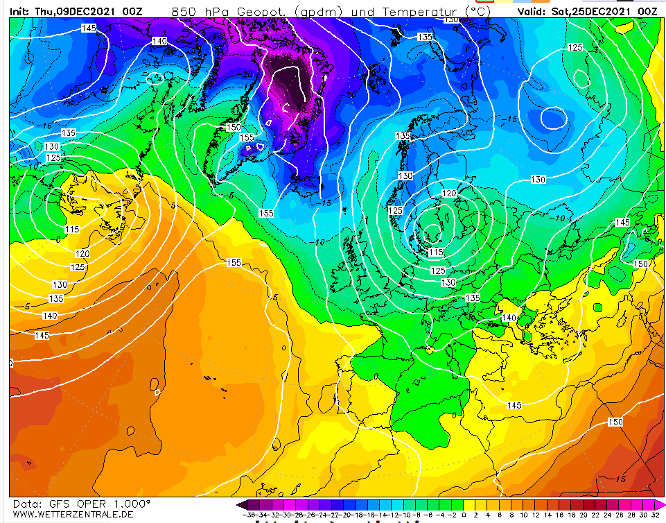
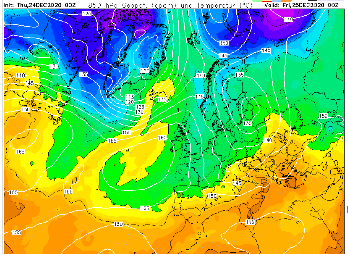
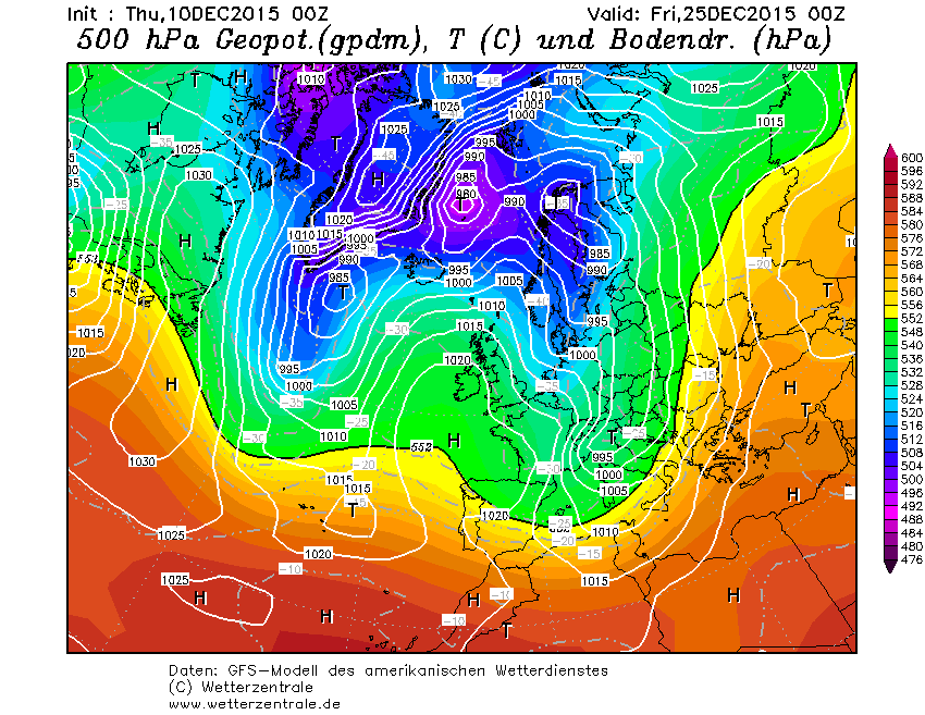
It’s that time of year again! With the midnight run of this model bringing the start of the 25th into range the prognosis for the big day is a rare white one – with snow likely almost anywhere.
But 15 days is an eternity in modelling so we can take this with a council depot load of salt.
It’s often not until 10 days out that models will start to get a firm grip on what the weather will be like on Christmas day.
My guess at this range is a quiet one with fog and frost and a high of 6C in London.
Friday, December 10th
24hrs on and, interestingly, the pattern hasn’t completely flipped to something opposite to above…
Saturday, December 11th
The high is more centrally located over the UK with proper cold air from eastern Switzerland eastwards. Cold, calm with frost and fog in London.
Sunday 12th December
Little change though any colder air is even further east. A Eurotrash high with declining air quality.
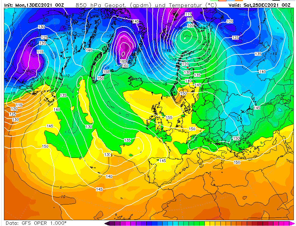
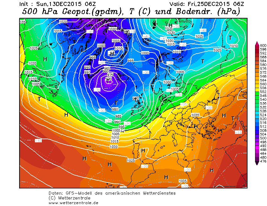
Monday 13th December
The models are in a state of flux, more so than usual by the looks of it. No change on my thoughts though.
Tuesday 14th December
Another slack flow with any true, cold air well to the east. My guess remains a dull and cold Christmas day after a slight morning frost.
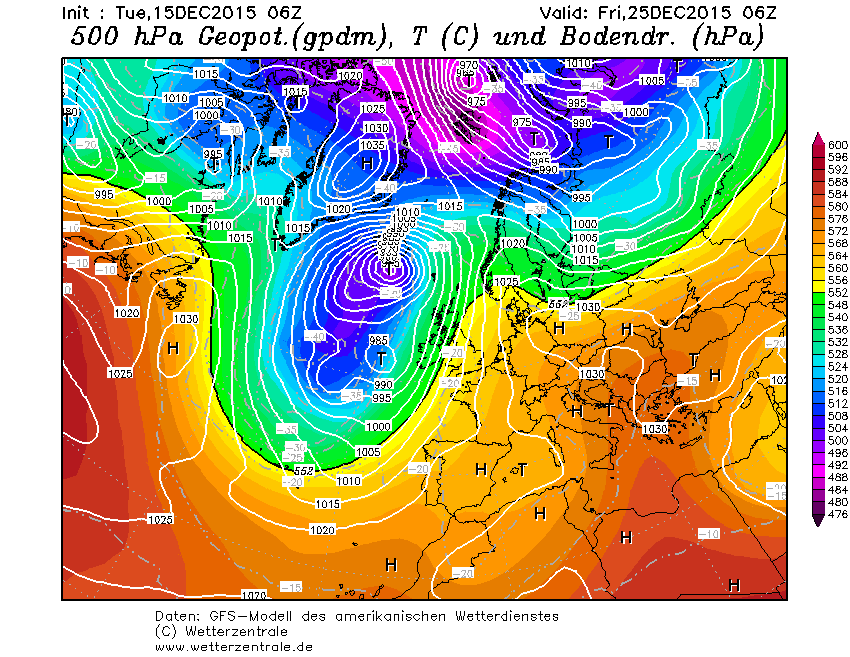
Wednesday 15th December
Within the much more reliable 10-day range now and the GFS is throwing out quite an odd looking chart. It shows a mass of cold air just to our east, the start of a cold spell that takes us up to New Year’s Eve.
Thursday 16th December
My thoughts on Christmas day still remain the same as they were days ago. Cold, calm with a high of 5C. Beyond that GFS is hinting the Atlantic floodgates will open. I suspect it is jumping the gun by a couple of days and we’ll see a couple of cold days, the 27th being notably cold?
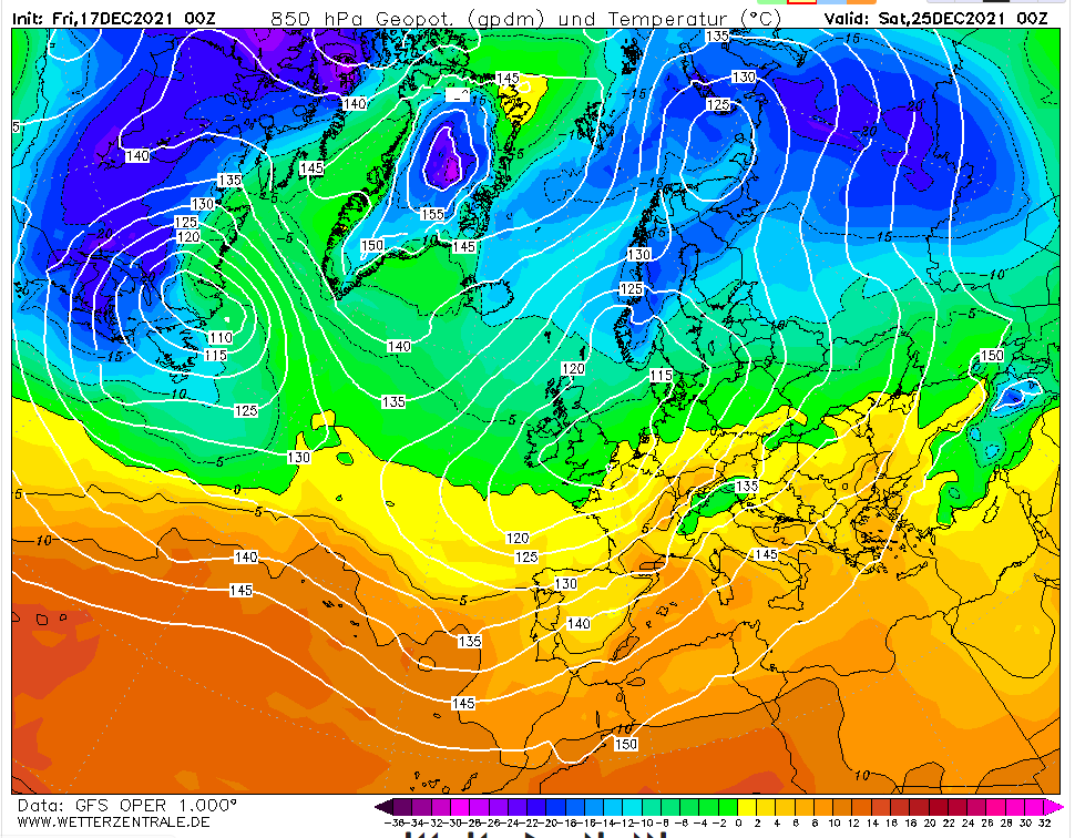
Friday 17th December
The GFS having another hiccup overnight. The situation at 0z hours probably 5C and cloudy in London. But it’s a deteriorating situation with 850mb temps plunging from the north – the conditions that could bring being consistent with the title of this blog. But I’d pay little notice to output like this until it is 48-72 hours away.
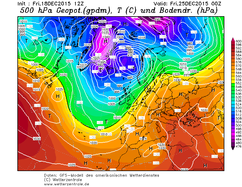
Saturday 18th December
A classic battleground scenario on the midnight operational. An even spread on ensembles, too. My hunch is that the high pressure will survive long enough for a quiet Christmas day. After that?
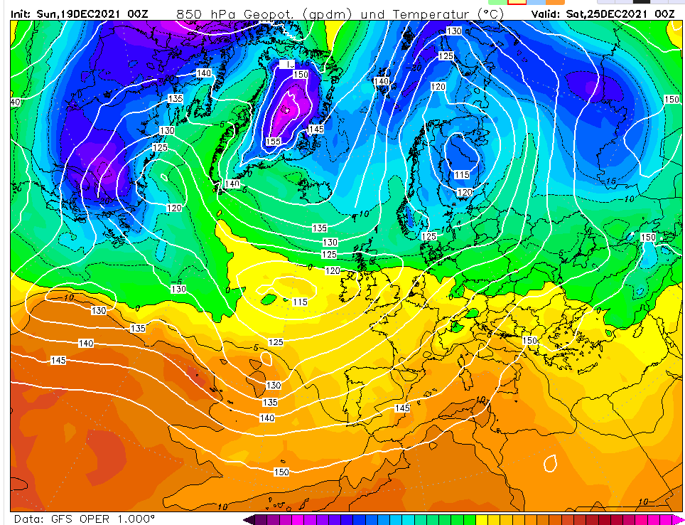
Sunday 19th December
GFS wants to bring 11C, outbreaks of rain this morning…
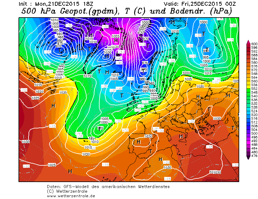
With the midnight run of this model bringing the start of the 25th into range the prognosis for the big day is a rare white one – for those north of the border.
The rest of the country is messy mix of sleet and, in London’s case, cold rain with a high of 7C. It looks fairly average for this locality!
The GFS operational chart for 0000 on the 25th
But followers of this blog and elsewhere will know that any model output beyond 72 hours should be taken with a very large pinch of salt.
But while conditions out to 15 days are often very different they can give a general guide to how the atmosphere is evolving in the medium range. The last few winters I’ve been doing this Christmas day model blog have revealed that conditions are sometimes not wildly different from what was hinted at 372 hours before.
Over the last few days the GFS, and other models, has been flip-flopping between cold and mild, a symptom of the current atmospheric situation which suggests that the polar vortex may undergo displacement as we progress further into winter. This could signal colder weather for NW Europe – but exactly where this colder weather will be as we progress to the end of the month is very uncertain – any colder than average weather could remain closer toward Central Europe, as happened in 2008.
Below are charts for each day from the midnight operational run of the GFS model.
The GFS model is now within range of the big day on the 25th. From now until Christmas Eve I will be having a look to see what is on offer.
The first operational run suggests something of interest but please bear in mind there is a long way to go yet. While operational runs are often exciting, the below suggests a potent northerly with snow for many, the right hand average is much more realistic though admittedly boring.
My own guess at this stage is for something benign, a high of 6C with a low of 2C, perhaps some frost early or late on?
10th: Op run this morning is showing quiet weather. A high of 4C after overnight frost.
11th: Op run now shows a slack north-easterly and possible snow.
13th: An anticyclone to the north of Scotland continues to keep things seasonal on the op run this morning. The average again benign.
14th: More interest on today’s midnight run. The op shows a cold pattern. Frost early and late and a high of 2 or 3C. A chance of flurries. Even the average looks less mild!
15th: The interest of yesterday has faded. Not terribly mild but not cold either. Xmas morning starting chilly, 6C with rain in the evening, a warm sector bring the temp up to 10C in the evening. The average suggests something similar.
17th: All change again on the op run today with an Atlantic ridge with plenty of cloud. High 7C Low 4C. Gloomy. The Average less settled…
18th: The op this morning suggests the 25th will be something of a changover from the present regime to something more settled. The op chart suggests a temperature of 9C day and night though perhaps the reality may see some frost late on in the day.
20th: It’s looking quiet and calm.
21st: quiet and calm.
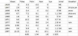
You can find out what every Christmas Day in London was like weatherwise here.
Earthquakes in Italy and early season snow cover in Siberia have been well documented in 2016.
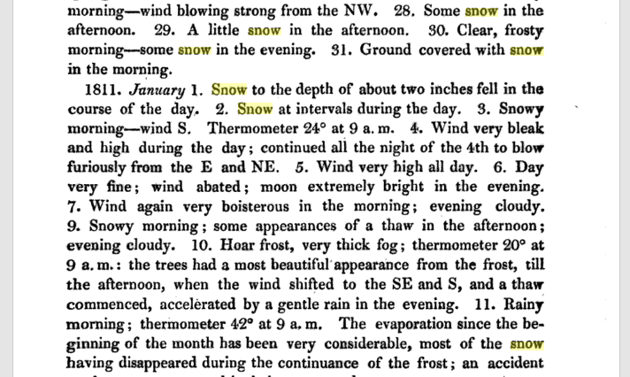
They were also mentioned by Luke Howard in his publication The Climate of London in 1810.
He also mentions winter thunderstorms over the Yuletide period, from Christmas Eve to Boxing Day – the amount of rain overflowing the Thames.
24th: Very windy night with heavy rain. 25th: Wind high all day with rain frequent lightning in the evening from SE. 26th: Wind very boisterous early in the morning day fine the rain of the last three or four days being impeded in its passage to the Thames by the spring tides overflowed the banks and filled the marshes.
Within two days of this wild and wet spell, complete with strong north-westerlies, the wind swung north and then north-easterly to usher in 1811 with a 12-day cold spell.
The conditions of the cold spell were not severe, the coldest night was -8C, it was a pretty standard cold spell for the time and one that the south-east used to experience with fair regularity in the early to mid 1980s.
Models currently show a (fairly) narrow chance of a stormy Christmas period. It would be interesting if it were followed with a cold spell in January – just like the ones we used to get in 1980s.
* The Booty website also contains the following on that notable month…
What is thought to be Britain’s strongest tornado occurred in December 1810. A category of “T8” (on a ten-point scale) occurred on the 14th at Old Portsmouth. The TORRO website says it: “tracked from Old Portsmouth to Southsea Common causing immense damage – although no deaths, it is believed. Some houses completely levelled and many others were so badly damaged that they had to be demolished; chimneys were blown down and the lead on a bank roof was ‘rolled up like a piece of canvas and blown from its situation’.”
Weather models are now in range of predicting the weather on Christmas Day and the all important question of ‘Will it be a white one?’
High pressure centred over the near continent leaves the UK in a feed of very mild air from the Azores
The operational output from the GFS model today answers that question with a resounding ‘no’. A huge anticyclone centred over the continent puts the UK in a very mild SWly feed, the air source from the Azores. You would expect temperatures in London to top around 12C after an overnight low of around 5C.
The Daily Star this morning was even more bullish with it’s splash proclaiming that punters had poured money into Yuletide being exceptionally mild, predicting 15C which would give last year’s record warm period a run for its money. But they have based this forecast on one operational outcome on one model!
Anyone who follows weather forecasts knows that there’s always huge uncertainty in outcomes beyond five days. So putting faith in this forecast 16 days before the event could be dismissed as plain stupid. A closer look at the ensembles – model solutions that pick out trends of several operational runs – suggest that there is very wide spread in outcomes for the weather for Christmas Day: either very cold or very mild! And the GFS system is also hampered by lack of vertical resolution in the stratosphere.
Punters are apparently piling money into it Xmas day being 15C – but ensemble forecasts at this range show outcomes from very mild to very cold.
Taking a broader view of what happens in real life over the last few years there always seems to be a pivotal moment around December 17th. The odds always have to favour the mild weather for us though.
Earlier this month in my November review I found that there was a 55% chance of a cold spell at the end of December. My guess at this range is that the run up to Christmas will see us under the influence of high pressure centred over the near continent – a ‘phantom’ cold spell that is cold at the surface but, at 850mb (5,000ft), well above freezing. Christmas day in London will start frosty with the temperature topping out at 5C or 6C. Any proper cold spell with snow will not bite until 29th.
That’s my guess. My advice to anyone who fancies a flutter is to hold on to your money until the 17th. Or place a bet on both.
* The definition of a white Christmas used most widely – notably by the bookies – is for a single snowflake, even if it lands in the midst of heavy rain, to be observed falling in the 24 hours of 25 December at a specified location recognised by the Met Office.
** On average, snow or sleet falls in the UK 5 days in December, compared with 7.6 days in January, 6.8 days in February and 6 days in March. White Christmases were more frequent in the 18th and 19th centuries, even more so before the change of calendar in 1752, which effectively brought Christmas back by 12 days. Climate change has also brought higher average temperatures over land and sea and this generally reduces the chances of a white Christmas.
The op chart for Christmas Day on 24/12 shows the UK split between influence from a low to the north of Scotland and a European high giving a balmy SW’ly . Rain moves up from the SW during the day. Temps in London rising to 13C after a low of 4C. Best chance of anything wintry northern Scotland
The odds for snow on Christmas Day have been shortened for those that live in northern Scotland, reflecting the latest operational model runs that suggest the current mild regime will continue in the south.
The operational runs of the weather model GFS began to include Christmas Day in its forecast on December 9. Admittedly T+384 is la-la land in terms of trying to accurately predict what the weather will be like on the day but I thought it would be fun to see how the outcome changes over the next two weeks or so.
William Hill odds for snow on Christmas Day:
9th: London 5/1; Aberdeen 5/2; Edinburgh 3/1; Glasgow 3/1; Newcastle 4/1; Belfast 5/1; Birmingham 6/1; Norwich Airport 7/1; Penzance 10/1
10th: unchanged. 11th: unchanged. 12th: unchanged. 13th: unchanged. 14th: unchanged. 15th: unchanged. 16th: London 8/1; Aberdeen 7/2; Edinburgh 4/1; Glasgow 4/1; Newcastle 5/1; Belfast 5/1; Birmingham 7/1; Norwich Airport 10/1; Penzance 16/1.
My predicted outcome for London made at the beginning of December: TMax: 7C TMin: 1C Moderate westerly 60% chance of rain shower 1hr of sunshine
Please note that the outcome will change markedly from run to run, day to day. The best hint of what the weather will be like will be from T=240z (10 days) and, reliably, T+120z. If the pattern is zonal then detail can only start being pinned down at T+72z.|
5C, variable winds with threat of rain approaching from south-west. Chance of wintry showers Liverpool northwards. Snow On Christmas Day 5/2 Aberdeen Airport 3/1 Edinburgh Airport 3/1 Glasgow Airport 4/1 Newcastle Airport 5/1 Belfast Int. Airport 5/1 Leeds Bradford Airport 5/1 Liverpool Airport 5/1 London Heathrow 6/1 Birmingham Airport 6/1 Dublin Airport 6/1 Manchester Airport 7/1 Bristol Airport 7/1 Cardiff Airport 7/1 Norwich Airport 10/1 Penzance RNAS Culdrose
The operational chart for Christmas Day on 10/12 shows ridging from the south allowing a brief spell of quiet weather. Temps in London a couple of degrees above freezing with frost at night. A flurry possible almost anywhere though east coast most likely.
The op chart for Christmas Day on 11/12 shows a ridge bringing a brief spell of cold, quiet weather. Temps in London about 6C after a cold, possibly frosty start. Dry to start though increased risk of rain from the west later. Best chance for anything sleety probably Glasgow…
The op chart for Christmas Day on 12/12 shows the UK in a col. Rain a possibility almost anywhere but chiefly in the SW and south. Temps in London about 6C and a low of 3C. Best chance for anything wintry probably Aberdeen toward midnight…
The op chart for Christmas Day on 13/12 shows the UK in a returning N’ly regime. Heavy rain spreading in to SW and S. Temps in London about 12C and a low of 6C. Best chance for anything wintry in the far north
The op chart for Christmas Day on 14/12 shows the UK in a returning N’ly regime. Starting dry in the SE but rain spreading in later. Temps in London peaking at 13C after a low of 10C. Best chance for anything wintry in the far north
The op chart for Christmas Day on 15/12 shows the UK split between a returning N’ly regime and a large area of high pressure centred over Switzerland, advecting warm air from North Africa. Mostly dry across the UK with best chance of precipitation NW Scotland. Temps in London peaking at 10C after a low of 7C. No chance of anything wintry, anywhere
The op chart for Christmas Day on 16/12 shows the UK split between a returning N’ly regime and a large area of high pressure over central Europe, advecting warm air from North Africa. A band of rain lies across the UK though dry in the SE. Temps in London peaking at 13C after a low of 11C. No chance of anything wintry, anywhere
The op chart for Christmas Day on 17/12 shows most of the UK in a balmy SW’ly regime, controlled by a strong high pressure over central Europe. Air over the SE is all the way from the Sahara. Any precipitation confined to Scotland. Temps in London peaking at 11C after a low of 8C. No chance of anything wintry, anywhere
The op chart for Christmas Day on 18/12 shows the UK split between influence from a low centred over Iceland and a European high giving a balmy SW’ly . Air over the SE is from northern Spain. A band of rain heralds cooler air from the NW. Temps in London peaking at 11C and falling away during the day. Best chance of anything wintry Western Isles of Scotland
The op chart for Christmas Day on 19/12 shows the UK split between low centred off north of Scotland introducing a cooler NW’ly airstream while south just about hangs on to the European high. A band of rain clears SE early on 25th from the NW. Temps in London peaking at 10C and falling away during the day. Best chance of anything wintry high ground in N England and northern Scotland
The op chart for Christmas Day on 20/12 shows the UK split between influence from a low to the north of Scotland and and a European high giving a balmy SW’ly . Rain moves in from the west during the day. Temps in London rising to 12 after a low of 4C. Best chance of anything wintry northern Scotland
The op chart for Christmas Day on 21/12 shows the UK split between influence from a low to the north of Scotland and and a European high giving a balmy SW’ly . Rain moves in from the west during the day. Temps in London rising to 12 after a low of 4C. Best chance of anything wintry northern Scotland
The op chart for Christmas Day on 22/12 shows the UK split between influence from a low to the north of Scotland and a European high giving a balmy SW’ly . Rain moves up from the SW during the day. Temps in London rising to 13C after a low of 4C. Best chance of anything wintry northern Scotland
The op chart for Christmas Day on 22/12 shows the UK split between influence from a low to the north of Scotland and a European high giving a balmy SW’ly . Rain moves up from the SW during the day. Temps in London rising to 13C after a low of 4C. Best chance of anything wintry northern Scotland
The op chart for Christmas Day on 23/12 shows the UK split between influence from a low to the north of Scotland and a European high giving a balmy SW’ly . Rain moves up from the SW during the day. Temps in London rising to 13C after a low of 4C. Best chance of anything wintry northern Scotland
Over the next two weeks speculation on Christmas Day weather will inevitably build. Will Christmas be white or green?
At this range it is impossible to tell from standard meteorological models though from the 15th, 10 days before the big day and when models can start to be relied upon for at least a general trend, the pieces of the weather jigsaw will start to fall into place.
Latest odds offered by bookies William Hill for a single snowflake at London Heathrow are currently 5-1, slightly shorter than I’d expect at this time of year. With the predominance of the European high I’d expect those odds to start to lengthen.
In terms of proper snow falling and settling, there has not been a white Christmas in Wanstead for over 30 years. In 2010, we could still see the Christmas card Victorian snow scene in small patches if our gardens, but these were leftovers of a previous dump, so it doesn’t count. There has been snow on several Boxing Days in Wanstead (1995 and 1996) and in the weeks running up to Christmas, but not on Christmas day itself. The most typical Wanstead Christmas day weather is mild and dry, although it has rained on 13 of the last 34 Christmas days.
In an earlier blog I had a look at what the last 170 or so Christmas Days in London were like weatherwise and found that snow actually falling on the day is extremely rare. Since 1840 there have been just 19 occasions of snow or sleet falling on the capital on Christmas Day which equates to a probability of just under 11%. If you consider that the last ‘white Christmas’ (see note) was in 1996, then we are well overdue one.
But the weather doesn’t adhere to human created calendars and behave like it should on any given day. But patterns in any given year can sometimes repeat though correctly predicting they will happen is more down to luck. Nevertheless I’ve had another look at my calculations for this winter and see if there is any way I can make a prediction for Christmas Day.
I firstly had a look at Christmas Day stats overall since 1840. The most common group of maxima in the series is 8.1C and above. This occurred 70 times or 40%. I then had a look at the years that most closely follow this October and November. Ten years were on the list – two saw a white Christmas: 1938 and 1968. Snow often falls before and after Christmas.
So my guess for the weather on Christmas Day this year is for a maximum temperature of 7C after an overnight low of around 1C. With a 60% chance of rain in a stiff westerly wind there is a chance of something sleety falling.
But the fact that 20 per cent of the years in the above series saw a ‘white’ Christmas suggests that, unlike last year which I called right, there is at least *some* chance of snow falling. If you insist on having a flutter, however, Liverpool airport at 5-1 looks most generous.
Going on past form it is possible that Christmas Day will be the ‘changeover’ day for something a bit more wintry as we head into the new year – but it looks like the north Midlands northwards will be the main beneficiary of any of the white stuff
* The definition of a white Christmas used most widely – notably by the bookies – is for a single snowflake, even if it lands in the midst of heavy rain, to be observed falling in the 24 hours of 25 December at a specified location recognised by the Met Office.
** On average, snow or sleet falls in the UK 5 days in December, compared with 7.6 days in January, 6.8 days in February and 6 days in March. White Christmases were more frequent in the 18th and 19th centuries, even more so before the change of calendar in 1752, which effectively brought Christmas back by 12 days. Climate change has also brought higher average temperatures over land and sea and this generally reduces the chances of a white Christmas.
Will it be a white Christmas this year? It’s the question most forecasters get asked year after year as the big day looms less than a month away.
The snow probably won’t arrive until after Christmas this year
It always fascinates me why Christmas and snow are so closely associated with each other when the odds, especially in London, are so stacked against it happening.
Perhaps it is the Christmas card scenes of Dickensian winters that get people yearning for the white stuff. Indeed, the image of snow covered cobbled streets can probably be blamed on Charles Dickens. The backdrop of A Christmas Carol, and a host of other books, were written when winters, and Yuletide, were generally much colder than they are now. Perhaps it was also the cold Decembers, which came during notably cold years as he was coming of age, that sowed the seed of his impressions of life in London. The Central England Temperature (CET) for December 1829 and 1830 were 1.4C and 1.8C respectively. To give you perspective the average mean temperature for the Wanstead region in December is 5.6C. Of course we had a taste of what a Dickensian December was like three years ago in 2010 when the average mean temperature was 1.5C. Though bear in mind the mean for 2010 was 10.5C – way above the 8.2C and 8.7C mean temps of 1829 and 1830!
Christmas toys of yesteryear also took every opportunity to perpetuate the snow myth
But back to this Christmas… First of all, what do we mean by a white Christmas? The definition used most widely – notably by the bookies – is for a single snowflake, even if it lands in the midst of heavy rain, to be observed falling in the 24 hours of 25 December at a specified location recognised by the Met Office. Interestingly, the Met Office uses weather observations from Gravesend-Broadness, some 12 miles away, to show current conditions in Wanstead. A lot, however, could be said by us weather anoraks about the different microclimates between here and south of the Thames.
Technically, there has not been a white Christmas in Wanstead for over 30 years. In 2010, we could still see the Christmas card Victorian snow scene in small patches of our gardens, but these were leftovers of a previous dump, so it doesn’t count. Frustratingly, there has been snow on several Boxing Days in Wanstead (1995 and 1996) and in the weeks running up to Christmas, but not on Christmas day itself. The most typical Wanstead Christmas day weather is mild and dry, although it has rained on 12 of the last 33 Christmas days.
So why does it often snow either side of Christmas but not on the actual day? For Wanstead, Christmas is at the beginning of the period when it’s likely to snow. Looking at climate history, wintry weather is more likely between January and March than December.
On average, snow or sleet falls in the UK 5 days in December, compared with 7.6 days in January, 6.8 days in February and 6 days in March. White Christmases were more frequent in the 18th and 19th centuries, even more so before the change of calendar in 1752, which effectively brought Christmas back by 12 days. Climate change has also brought higher average temperatures over land and sea and this generally reduces the chances of a white Christmas.
For snow to fall we need moisture in the atmosphere. Snowflakes start their lives as ice crystals thousands of feet up, and when these tiny ice crystals collide they stick together in clouds to become snowflakes. If enough ice crystals stick together, they’ll become heavy enough to fall to the ground.
Precipitation falls as snow when the air temperature is below 2°C. It is a myth that it needs to be below zero to snow. In fact, in this country, the heaviest snowfalls tend to occur when the air temperature is between zero and 2°C. The falling snow does begin to melt as soon as the temperature rises above freezing, but as the melting process begins, the air around the snowflake is cooled. If the temperature is warmer than 2 °C then the snowflake will melt and fall as sleet rather than snow, and if it’s warmer still, it will be rain.
It sounds a simple combination, but getting precipitation on the days when there are temperatures low enough for snow are few and far between.
Christmas day in Wanstead, on the balance of probability and from previous patterns, is most likely to be a green and mostly cloudy but dry one. Some brightness is possible with temperature peaking at around 10°C. You can read my full methodology on why I think this may happen here.
Though my attempt to find the probability of a White Christmas effectively rules one out, there is still an outside chance that one could happen.
At this time of year the UK can effectively become a battleground between cold polar continental air to the north or east and moisture-laden mild tropical maritime air to the south and west. Where these air masses meet, snow is possible, but a lot depends on which air mass wins the battle. When battleground situations occur, in one location it can be snowing, but just 20 miles or so down the road it can be raining. This is because there is a fine line between the boundary of the warm and cold air.
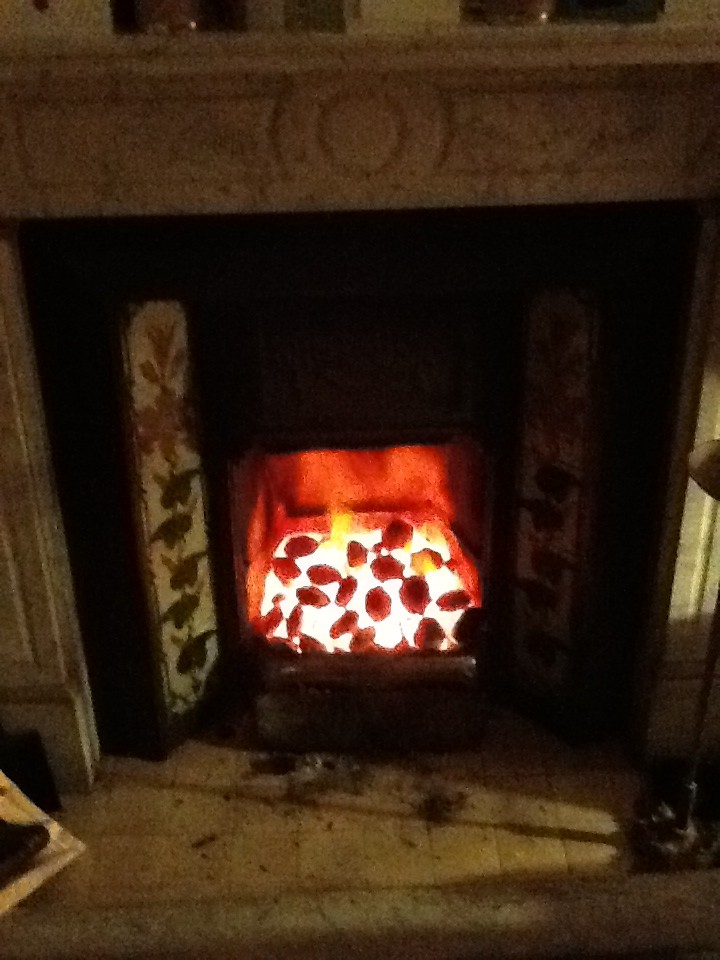
There’s nothing like an open coal fire. It’s even better when it is cold enough outside to have one
In years gone by, Wanstead and the surrounding area has often ended up in the cold air mass or the warm air mass. In these situations dry and mild or dry and cold weather is often the result. Of course, in a cold air mass situation there is always the chance of showery activity of the North Sea. The weather so far this winter has not been anything out of the ordinary, so I’m afraid there is nothing to suggest a white Christmas is likely.
If it does turn very cold on December 24, pray for clouds to appear and we could be in with a chance. But at the end of the day we still need that vital combination of temperature and moisture. Snow, like Christmas in that sense, requires some magic.


 So my guess for the weather on Christmas Day this year is for a maximum temperature of 7C after an overnight low of around 1C. With a 60% chance of rain in a stiff westerly wind there is a chance of something sleety falling.


You must be logged in to post a comment.