All posts by wansteadmeteo

A blog that tries to make sense of how the UK's national climate translates into local weather for Wanstead and the surrounding regions of east London and west Essex. Check out my twitter feed @wanstead_meteo for local weather forecasts, stats, records and phenomena for the east London areas of Wanstead, Aldersbrook, Leytonstone and Stratford. And anything else weather

Paris rats, rain, floods and snow

It’s all been happening in the French capital recently with deep snow replacing floods and rats as the main problem hampering residents. paris

Some great footage is doing the rounds on social media of people of varying abilities partaking in various wintersports; Montmartre hill turning into an impromptu playground.

Last month parts of the city flooded, the Seine swollen by higher than usual rainfall in the area surrounding the city.

The high water levels appears to have flushed the rats out of the sewers, the rodents having nowhere to go except ground level.


https://twitter.com/Paris_Newz/status/956251478653620224


The severe cold spell of February 1991

The cold spell of February 1991 saw unusually deep snowfall in central London. The 20cm recorded at St James’s Park on the 8th was the greatest cover recorded at the site since the severe winter of 1962/63.

summ821991
Courtesy of the Met Office

My own memory of the event was that the synoptics evolved fairly quickly. I was away at university at the time and had to be back for a family event that weekend. After seeing a forecast predicting that a foot of snow was on the way I jumped on a train a day earlier than planned and returned to London. The following morning all hell had broken loose as deep snow paralysed public transport.

Snow fell on the following 6 days with no thawing as the temperature remained below zero until the 10th. The maximum of the 7th was -3C. By the 9th there was widely 20cm of level powdery snow lying. Getting around was difficult – I remember some drifts during walks into town were thigh high.

The month saw the three coldest February days of the last 60 years in central London.

By the end of the 19th all of the British Isles were snow free.

February 1991
February 1991 in suburban east London

The nine charts below show how a strong ridge of high pressure from an anticyclone over northern Sweden on the 5th brought very cold air and heavy snowfall over the following days.

These significant weather charts show the snow depths at noon from 6th to the 13th.


summ1021991
Courtesy of the Met Office

Ian McCaskill’s late evening BBC forecast on February 6th.

Francis Wilson’s breakfast telly forecast on February 7th 1991: “Temperatures rising from -11 to -5C. Depths in excess of a foot. It’s all downhill from now.”

Harlow, Essex, during the cold spell.

January 2018: rather mild, wet, dull

January 2017 was a wet month. Just over 64mm of rain was recorded, 121 per cent of average, slightly less than last January.Screen Shot 2018-02-04 at 21.20.29

The monthly mean finished 6.4C, 1.2C above average and the mildest January for four years.

Some 44 hours of sunshine were recorded, 88 per cent of average, the dullest January for six years.

The most notable event was during the early hours of the 18th when the ‘storm with no name’ felled many mature trees across a swathe of England, including a large beech on Blake Hall Road that led to the closure of the road during morning rush hour.

Air frosts: 4. Ground frosts: 12. Snow falling: 1


Full stats for January here:http://1drv.ms/1rSfT7Y

Summary for January 2018
Temperature (°C):
Mean (1 minute)  6.5
Mean (min+max)   6.4
Mean Minimum     3.5
Mean Maximum     9.3
Minimum          -2.4 day 29
Maximum          13.5 day 28
Highest Minimum  10.8 day 28
Lowest Maximum   4.1 day 20
Air frosts       4
Rainfall (mm):
Total for month  64.4
Wettest day      15.3 day 02
High rain rate   28.2 day 02
Rain days        19
Dry days         12
Wind (mph):
Highest Gust     45.0 day 02
Average Speed    4.2
Wind Run         3124.8 miles
Gale days        1
Pressure (mb):
Maximum          1031.2 day 29
Minimum          986.4 day 02
Days with snow falling         1
Days with snow lying at 0900   0
Total hours of sunshine        44.1

London’s February extremes since 1959

I’ve put together a few top 10s of stats for Wanstead, St James’s Park and Heathrow for the month of February.

Probably most notable is the cold February of 1991 which saw the deepest snowfall I can remember – days of snow saw the level depth past my knee in suburban London. February 1986 was also very cold but also very dry with little snow.

Februaries in the 1990s were also often warm with 19.7C being reached in Wanstead on 13th in 1998.

It is a shame that the Met Office only publishes easy to access daily data in Excel format back to 1959 as this obviously omits the classic snowy February of 1947 which is worth a blog on its own.

My winter forecast for the London area can be found here.

wanstead feb

top 10 heathrow feb

SJP top 10 feb

Some national UK February values according to TORRO

Hottest: 21.2C Kew Gardens – 26th 2019
Coldest: -27.2C Braemar – 11th 1895
Wettest: 196.6mm Ben Nevis, Highland – 6th 1894

feb max av

The ‘nearly cold spell’ of February 2008

Recent model output that has many bullishly predicting a cold spell in February reminds me of the winter of 2008 when the likes of the GFS and ECMWF models kept teasing us that a Scandinavian high pressure was imminent.

This rare pattern brings the south-east its coldest weather in winter, in the past bringing the January 1987 and February 1991 cold spells.

feb16
Midnight on February 16th 2008 just before the high moved south, taking its cold weather into the Balkans

A look back at the pressure patterns in 2008 show that high pressure was in the ‘right place’ between the 11th and 16th but, just as -10C uppers looked poised to flood across from eastern Europe, the high pressure collapsed south, leaving the UK in a SE’ly flow off a mild France.

There was snow in 2008 but it didn’t arrive until the spring, in late March and, the best fall, in early April when I remember waking up on the 6th to a 5cm covering that mostly melted by lunchtime.

I suppose the one silver lining for any coldies reading this is that February 2008 was the sunniest on record.

2017
The mean temperature for December 1st – January 30th is 6C for both 2007/08 and 2017/18

The maps below show the sea surface temperature anomalies. A slight La Nina on both. ENSO, considering my winter forecast, has been the best guide for how this winter has so-far panned out – front loaded.

Screen Shot 2018-01-30 at 11.49.50

Screen Shot 2018-01-30 at 11.50.40

wl
Philip Eden’s column in the journal Weather showed that there was some wintry weather in February 2008 but it was restricted to the north of England northwards

* The focus of these blogs is usually on what the weather was, or may be, like in my backyard – though they usually broadly apply to anywhere in the south-east that is close to sea level.

Past weather to rescue future reporting

“Worst floods ever!” Hyperbolic reporting of weather events is nothing new; whenever the UK is hit by the latest named storm breathless news anchors often try to portray atrocious conditions as ‘unprecedented’. This may soon change thanks to a project that uses citizen science.

Operation Weather Rescue, the citizen science project which last year processed Ben Nevis and Fort William data from between 1883 and 1904, has now recovered thousands of European observations from past Daily Weather Reports compiled from 1900-1903.

Though reanalysis data of the northern hemisphere back to 1851 have been available for some years the maps don’t give enough detail to be able to compare if an old storm has the same pressure characteristics as a modern storm. Evidence of impacts is restricted to fixed observations such as temperature, rainfall and archive press reports.

Weather Rescue: “We want to learn about the frequency of intense storms in the past to compare with now and these rescued observations will significantly improve our understanding.”

The latest release of data features pressure plots from June 1903 that tie in with the record-breaking 59-hour deluge that left much of the London Borough of Redbridge underwater. The following October, nationally, was the wettest month ever recorded in the UK.

Further recovery of these archived data, with the help of thousands of volunteers, will prove invaluable to our understanding of high-impact weather, and if storms are getting worse.

This latest example of Big Data could also offer huge benefits to the insurance and reinsurance industries, as well as planning engineers, as the resolution of climate models steadily improve.

But on a purely weather reporting scale it should also be possible to one day provide the media with a quickly accessible database of weather events going back over a century, enabling them to judge whether the latest storm really is the worst in 100 years.

In this age of clickbait journalism, however, I’m not holding my breath!

rescue

Best Alpine snow for 30 years?

There’s been countless reports about amazing amounts of snow falling across the French, Swiss and Italian Alps to the point where some agencies have been proclaiming that it has been the best season for the white stuff in 30 years.

Extraordinary totals have fallen in some areas. Bourg-St-Maurice, the jumping off point for Savoie resorts including Les Arcs and Val d’Isere, has recorded over 400mm of precipitation over the past 30 days, equating to around 4m of snow at the resort summits.

In Switzerland, large amounts of snow in a short period caused chaos in Zermatt, stranding tourists after the area’s rail services suffered disruption.

Away from the north and west side of the Alps, however, snowfall, while good, has been less impressive the further south and east you look.

alps arrow
30-day precipitation totals reveal that Bourg St Maurice recorded 422mm while Obertauern in the east recorded 99mm. 

It is a far cry from last year where some resorts on the southern side of the range were particularly dry. San Bernardino, during the last 30-days, has recorded 179mm of precipitation. During the same period last year just 14.6mm fell!

The outlook for the Alps continues to look unsettled with snow forecast to fall at resorts that are in deficit to the Valais and Savoie areas.

snow


The same old weather every year?

Recurring weather patterns at certain times of the year are well known. The ‘Buchan Cold Spell’, ‘European Monsoon’ and Indian / St Martin’s Summer are all phenomena that have been studied extensively.

An article by the late meteorologist and broadcaster Philip Eden a number of years ago considered many of these patterns and found that, to varying degrees of reliability, they provided a guide to what the weather would be like at any given time of the year.

Considering climate change I wondered how much these patterns could still be relied on. Using my own pressure, rainfall and ‘wind run’ data (the total amount of daily wind) going back to the start of 2013 I had a look at the singularities for January and February

January patterns at the beginning, middle and end of the month appear to be the most reliable. However, it is only the ‘mid-Jan settled’ period that is most reliable.

singulariuty

pressure
The pressure trace most notably shows a general rise from the 17th, the date of last week’s windstorm, consistent with the mid-January settled singularity.
rain
Though this year’s ‘settled’ January spell saw rain the past 5 years have seen mostly dry weather.
windrun
Very little wind has been recorded around January 20th for the past 5 years

The early Feb settled spell occurs with very low probability: just 56 per cent. And this year the pressure, according to the GFS model, plotted below by WXCharts.eu, is predicted to be around 1040mb by February 2!

out to feb 1

new gif
This animation of the GFS model shows the idea of the Iceland low, which drives our SW’ly type weather, ‘taking a holiday’ to southern Iberia, possibly advecting any cold weather in the east to flood the UK

Looking at the results of the past 5 years it could be concluded that the patterns do still occur but because of the nature of the jet stream, which seems to meander far more readily than in the past, these stormy / quiet episodes are becoming shorter than they were in previous studies.


A 100% guaranteed snow risk for rest of winter

This weekend marks the halfway point through winter. Though December brought some snow January has been broadly average – really cold air has been absent with only one air frost recorded this month.

The cloudy, anticyclonic type weather is about to be replaced, however, with cold, polar maritime air this week set to flood down from the north-west.

Since December 1st, Wanstead has recorded 12 air frosts – about average. The coldest night was just -3.7C. The current mean temperature this winter to January 14th is 5.7C with rainfall 111mm – statistics that are remarkably similar to the winters of 2012/13 and 1990/91. Both those seasons were followed by cold late winters, February 1991 saw some of the deepest snow that I’ve ever seen in the south-east; the mean temp for that February finished 1.6C, the 14th coldest in the local series going back to 1797.

Using my method for finding patterns stretching back over 50 years to forecast this winter I picked out years that were +/- 10% of the 2017/18 total rainfall. From these I then weeded out the seasons where the average temperature was +/- 10% of the 2017/18 mean.

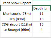
This gave a list of just two other winters with similar temperature and rainfall. Both winters had above average ‘snow lying’ days, the long terms average for this area being six.

Before any readers accuse me of going all Daily Express with the title of this blog I would emphasise that this piece doesn’t echo the latest long-term output from the models, which are in a state of flux, caused mostly by the evolution of the explosive cyclogenesis expected midweek. It is simply a reflection of what the local data is telling me.

A 100% guarantee of snow isn’t such a fantastical claim as, during the past 10 years, there is only one winter when no snow fell or was lying at 9am!

In terms of the rest of the winter, outside of the models, I would expect a couple more snowfall episodes, similar to the ones we had in January and February 2013. A repeat of February 1991, while not impossible, looks unlikely – there seems to be far too much energy coming from the Atlantic to allow the all important Scandinavian / Russian high to form and exert its influence far enough west for long-lasting cold and snow.

Philip Eden, 1951-2018

Following on from the announcement about the death of Philip Eden I have been emailed this by Roger Brugge of the Climatological Observers Link. Screen Shot 2018-01-10 at 11.55.47

“Announcement: Philip Eden, 1951-2018

I have this morning received the following message from Philp Eden’s
brothers, John and David:

It is with profound sadness that we have to report the death of
our brother, Philip Eden (Geoffrey Philip Eden), Meteorologist,
Broadcaster and Author, on 4th January 2018. He had been suffering
from Lewy Bodies dementia, but died as the result of head injuries
sustained after collapsing and falling several days earlier. He died
peacefully in a nursing home whilst receiving palliative care.

Please pass this sad news on to colleagues who knew or worked with Philip.

Details of the funeral arrangements will follow in a few days, but
anyone interested in attending should contact David Eden
at zen13966@zen.co.uk

John and David Eden (brothers)

Members will join with me in expressing condolences to Philip’s family,
and mourning Philip’s passing. COL will be represented at Philip’s funeral,
and myself or Roger will gladly pass on any messages from members.

Stephen Burt
COL Chairman
10 January 2018”

Many tributes have been paid on Twitter and elsewhere.

jane garvey

meteogib

blaby

mosey

phil

seven

There is a nice obituary on the Telegraph website: http://www.telegraph.co.uk/obituaries/2018/01/10/philip-eden-meteorologist-obituary/?WT.mc_id=tmg_share_tw