Tag Archives: UK snowfall

Cathedrals of snow

Snow is ever present in the UK in most years though you have to look hard to find it in high summer.

A dedicated group of enthusiasts, led by Iain Cameron, chart and catalogue these snow patches – many of which are hidden or only seen as distant white dots during Scottish Highland walks.

Responding to an appeal in September I met up with Iain and other volunteers to chart the patches in Observatory Gully on Ben Nevis, the UK’s tallest mountain.

Our route up in the shadow of the magnificent north face of the Ben was a warm one; to our left a procession of ant-like figures were tracking the CMD arrete route to the summit, walkers making the most of the amazing weather.

The North Face path up to the Ben was easy to follow under clear blue skies. My previous visits to the fogged-in summit required map and compass.

Out of the sunshine it was noticeably colder in Observatory Gully; being north facing it sees very little of the sun even in mid June, slowing down the rate of melt of the snow which can be tens of feet thick by the end of the snowfall season. Being encased in snow for so long obviously has a chilling effect on the rock.

The walk up on the scree was hard work and I was surprised to see so many debris including parts of large parts of old galvanised chimney cowls, the legacy of the observatory that once sat proudly on top of the Ben. Not many people trek this way, being a bit of a cul-de-sac. To reach the 1,345m summit from here requires a 200m climb at the end.

As we edged higher the dot of snow grew ever larger and is surprisingly big by the time we reached it, Iain was surprised how hard the snow was. From Iain’s reports, published in the Royal Meteorological Society’s Weather magazine, I’d been fascinated by the images of the patches with naturally carved tunnels underneath them; the light inside the ‘cave’ has a gorgeous blue hue to it.

The light inside the snow patch has a gorgeous blue hue to it. It is understandable why so many are drawn to these ‘cathedrals of snow’.

It was at this moment that I realised that this was a large part of the draw of tracking these patches; a fascination with snow in an area where the odds of it existing all year round seem to be forever diminishing.

At the start of Observatory Gully the snow patch is a tiny dot.
On closer inspection the snow patch is a few dozen feet across and is far bigger than it looks from the valley.

Seasons of melt and snowfall

Snow has only vanished entirely in Scotland six times. Three of these occasions were in 2003, 2006 and 2017.

Mean temperature statistics from Cairngorm Summit show just how much the seasons can vary. Of course mean temperature is just one variable that affects snow survival rates. For example the Western Highlands saw huge amounts of snow fall in February and March above 300m, a factor that would have helped snow survive. Though the most recent melt season was 0.4C cooler than 2019 there was probably a far greater volume of snow.

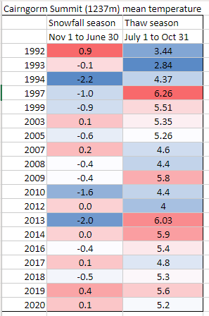
* Because of the unreliable nature of mountain-top records the Met Office data for Cairngorm Summit has some large gaps, it is only the last 5 years that have complete records . I discounted any years that were missing more than 5% of data.

Advertisement

Repeat of March 24th 2013 only 10C colder

The weather this coming weekend reminds me of a March weekend in 2013 when large parts of the south-east woke up to a covering of snow.

Conditions in Wanstead were very knife-edge, the cover being very slushy. I remember going for a bike ride on that Sunday morning. We left Aldersbrook in sleet, the cover grew thicker as we pedalled into Essex. By the time we reached High Beach near Epping there was 8cm of fresh cover. Conditions on the 2-hour plus ride were inclement to say the least – the temperature didn’t rise above 0C!

This weekend we have a similar set-up, only this time the upper air at 5,000ft is a good 10C colder – no knife-edges this time and, if the streamer gets going, many places should see 10cm of cover. Don’t put away that sledge just yet!


The severe cold spell of February 1991

The cold spell of February 1991 saw unusually deep snowfall in central London. The 20cm recorded at St James’s Park on the 8th was the greatest cover recorded at the site since the severe winter of 1962/63.

summ821991
Courtesy of the Met Office

My own memory of the event was that the synoptics evolved fairly quickly. I was away at university at the time and had to be back for a family event that weekend. After seeing a forecast predicting that a foot of snow was on the way I jumped on a train a day earlier than planned and returned to London. The following morning all hell had broken loose as deep snow paralysed public transport.

Snow fell on the following 6 days with no thawing as the temperature remained below zero until the 10th. The maximum of the 7th was -3C. By the 9th there was widely 20cm of level powdery snow lying. Getting around was difficult – I remember some drifts during walks into town were thigh high.

The month saw the three coldest February days of the last 60 years in central London.

By the end of the 19th all of the British Isles were snow free.

February 1991
February 1991 in suburban east London

The nine charts below show how a strong ridge of high pressure from an anticyclone over northern Sweden on the 5th brought very cold air and heavy snowfall over the following days.

These significant weather charts show the snow depths at noon from 6th to the 13th.


summ1021991
Courtesy of the Met Office

Ian McCaskill’s late evening BBC forecast on February 6th.

Francis Wilson’s breakfast telly forecast on February 7th 1991: “Temperatures rising from -11 to -5C. Depths in excess of a foot. It’s all downhill from now.”

Harlow, Essex, during the cold spell.