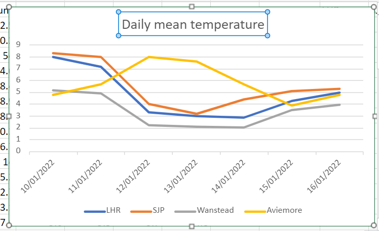
That’s not a statement that applies much, least of all the second week of January. But the current weather pattern has seen this town in the Highlands subject to the warming influence of the Atlantic, to a higher degree than London.
The above 850mb chart, typical of the past week, shows the warmer air aloft and the south of the UK seemingly cut off from outside influence.
Indeed, lack of solar heating at this time of year ensures that any thermal activity is minimal – with very little mixing of the boundary layers by day.
Wanstead Park, being a frost hollow, has seen this phenomena most days during the past week with this part of London markedly colder than elsewhere in the capital.
By the 16th the 7-day running mean at Aviemore was 2.4C higher than Wanstead!
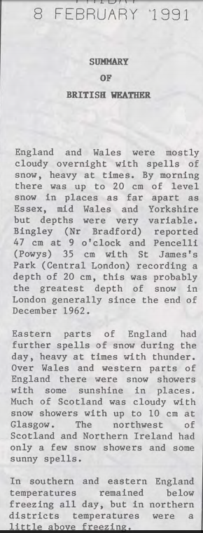
The cold spell of February 1991 saw unusually deep snowfall in central London. The 20cm recorded at St James’s Park on the 8th was the greatest cover recorded at the site since the severe winter of 1962/63.
Courtesy of the Met Office
My own memory of the event was that the synoptics evolved fairly quickly. I was away at university at the time and had to be back for a family event that weekend. After seeing a forecast predicting that a foot of snow was on the way I jumped on a train a day earlier than planned and returned to London. The following morning all hell had broken loose as deep snow paralysed public transport.
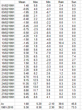
Snow fell on the following 6 days with no thawing as the temperature remained below zero until the 10th. The maximum of the 7th was -3C. By the 9th there was widely 20cm of level powdery snow lying. Getting around was difficult – I remember some drifts during walks into town were thigh high.
By the end of the 19th all of the British Isles were snow free.
February 1991 in suburban east London
The nine charts below show how a strong ridge of high pressure from an anticyclone over northern Sweden on the 5th brought very cold air and heavy snowfall over the following days.
05021991
06021991
07021991
08021991
09021991
10021991
11021991
12021991
13021991
These significant weather charts show the snow depths at noon from 6th to the 13th.
06021991
07021991
08021991
09021991
10021991
11021991
12021991
13021991
Courtesy of the Met Office
Ian McCaskill’s late evening BBC forecast on February 6th.
Francis Wilson’s breakfast telly forecast on February 7th 1991: “Temperatures rising from -11 to -5C. Depths in excess of a foot. It’s all downhill from now.”


You must be logged in to post a comment.