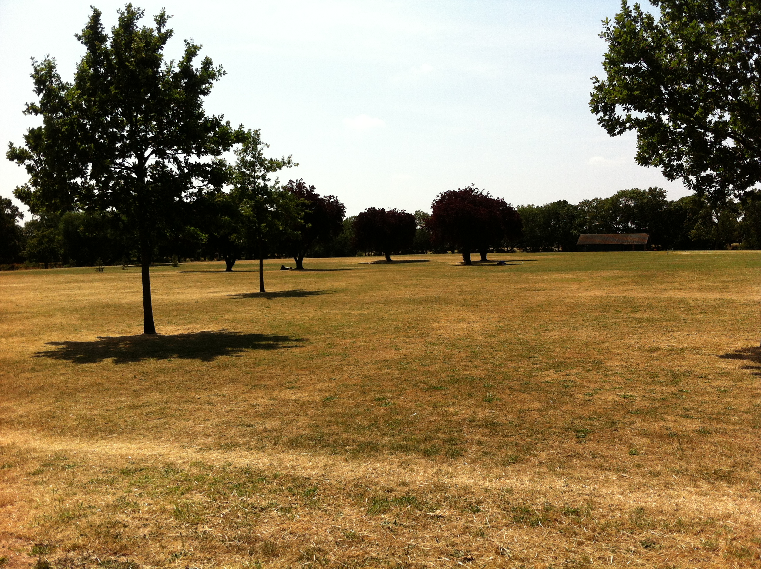
Summer 2016 turned out to be a very decent season overall, the mean temperature of 18.7C (1.1C above average) made it the sixth warmest summer since 1797.
While it wasn’t quite up there with the hot summers of 1976 and 2003 it still produced some notable records. The stormy beginning to June effectively ended with the Brexit vote, a period of 24 hours that coincided with the highest daily rainfall this area has seen since at least 1959.
The multi-cell thunderstorm in the early hours of June 23rd produced 60.8mm of rainfall, nearly half of the month’s total which became the third wettest June in a record going back to 1797. The high rainfall was in complete contrast to July and August and helped skew the overall figure: 168.6mm is 114 per cent over average summer rainfall.
With so much rainfall overall sunshine was affected with only 451 hours recorded, just 80 per cent of what can be expected in an average summer.
July produced another record, this time the highest overnight minimum recorded since 1959. The minimum of 21.1C was recorded during the early hours of the 20th – coming hours after the hottest day of the year: 33.5C – the 14th hottest day on record.
The warm and very dry theme continued into the final month of summer with the warmest August for 12 years, the 10th warmest and 12th driest since 1797.
My summer forecast, when the monthly probabilities are considered, was broadly correct though I didn’t estimate correctly just how warm it would be.
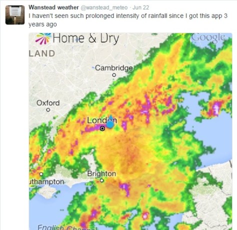
The past week has produced the highest 24-hour rainfall total recorded in Wanstead since at least 1960. The multi-cell thunderstorm on Wednesday night saw 60.8mm fall, most of it in two hours, bringing flash floods to the surrounding area. The spectacular lightning and thunder that accompanied it was almost a side show such was the intensity of the rainfall.
An image from the Home & Dry app revealed a succession of dark red echoes passing over our area. The heaviest rain seemed to run on a line from Battersea to Romford
I was unfortunate enough to be riding home right in the middle of the event: the entire length of the Mile End Road bore a resemblance to a shallow river, the heavy rainfall bouncing back off the Tarmac high enough to create what felt like a powerful drench shower.
The legacy of the downpours caused chaos in the morning and evening rush-hours. Many commuters were stranded at London terminals including Waterloo station because of flooded tracks, possibly robbing many of the chance of voting in the EU referendum. It will never be known if this would have had a bearing on the final result.
Many people think of June as a warm, summery month. The term Flaming June is regarded in most peoples’ subconscious as a reference to past weather. That it is a actually the name of a painting is often missed. Looking back through our local history there has been many notable events of thunderstorms and prolonged rainfall. In 1903 a record-breaking 59-hour deluge left vast swaths of the borough inundated.
The offical UK weather station totals all recorded less than Wanstead
This weekend 200 years ago, during the Year Without a Summer, a powerful tornado, strong enough to carry away objects weighing 60lbs, tore through the Edgware Road area in west London. Luke Howard recorded the event in the Climate of London.
At two o’clock being a still sultry day a whirlwind passed over the nursery ground of Mr Henderson in the Edgware Road which lifted seven lights from the greenhouses and carried them to the height of the highest elm trees, each of the lights weighs 50 or 60lbs at least. At the same time two garden mats were carried to an immense height so that the eye could not distinguish them.
The following day “extremely heavy and prolonged rain from 9am (26th) to 9am on 27th gave 2.95 inches”. This total of over 52mm is notably high though not a record.
This weather was a continuation of what had been an awful May and June – cold with more than twice the average rainfall in June.
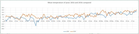
The weather then was not unlike what we have experienced this month. Indeed, a look at the weather throughout this year was similar as this graph shows.
Though the mean temperature at times bears a close resemblance this year is no comparison to 1816: The mean then was running at 6.2C, over 3 degrees colder than today.
Mean pressure was also lower being 992.1mb; the 2016 mean 9am pressure is 1010.6mb.
Perhaps not surprisingly this year’s rainfall actually trumps 200 years ago; the running total for rainfall here is 390.1mm, higher than the 309.6mm recorded in 1816.
The dreary summer and frequent thunderstorms of 1816 inspired Mary Shelley to write Frankenstein. A summer vacation in Switzerland led her to spend much of the time indoors. She, along with Lord Byron and John William Polidori entertained each other with a contest to write the scariest story of all. The unseasonal conditions, along with this dare, led to the creation of Shelley’s Frankenstein: The Modern Prometheus— as well as Polidori’s novella The Vampyre and Byron’s long-form poem, The Darkness.
It will be interesting to see if this June’s weather, along with momentous political changes here and in Europe, produce more fine fiction from the this and the next generation of writers.
Wind speed during the event from 2300 to 1000Temperature during the event from 2300 to 1000Pressure during the event from 2300 to 1000Rainfall from 2300 to 1000Rainfall rate from 2300 to 1000
April 2016 has seen more occurrences of thunder than we can expect during a typical July.
About an inch of hail collected on borders in gardens in Plaistow during a thunderstorm on 29th. This stuck around for over an hour thanks to the low humidity
A persistent flow of unstable Polar maritime air, coupled together with strong sunshine, provided the perfect ingredients for some really beefy showers.
The mean temperature of 9C was 0.8C cooler than average, the coldest April for three years and in stark contrast to the previous two Aprils that were mild and very dry. Air frost, notable for its absence in the previous two Aprils, returned with four incidences where the temperature dipped below freezing
Apart from a dry slot in the third week rainfall was fairly steady: 52.5mm is 124% of average for this area. It was the wettest April for four years.
A depression on 15th led to the wettest 24hrs of April
Sunshine was just below average. Over 153 hours were recorded, 96% of what we can expect to see during an average April.
The wettest day occurred on the 15th with 15.9mm, rain associated with a depression that ran along the Channel coast out into the North Sea, a system that heralded the colder pattern that defined the rest of the month.
Air frosts: 4, Ground frosts: 12
So what has May got in store weatherwise? The models on the 1st suggest that rather warmer weather will develop as we finally lose the northerly-sourced airflow and low pressure across the UK.
The radar on 29th shows a thunderstorm right over Plaistow to the south of Wanstead
Low pressure to the NW will become influential with strong and milder WSW winds driving wind and rain bearing fronts east and SE across the UK late on Sunday and Monday. A bright and brisk NWly flow with sunshine and showers then looks likely to be replaced by a ridge of high pressure and drier weather. It will begin to feel quite warm in any sunshine across the south from midweek.
Beyond that the outlook is uncertain though it appears warmer, if changeable, conditions will prevail.
Beyond the grasp of the models my long range outlook method has conflicting signals. The highest probability is 32% for something rather cool. Average is 28% while rather mild comes in at 20% probability. Something cool comes in at 12%, while mild is 8% probability. Both cool and very mild have a probability of just 4%.
A wetter than average month looks most likely at 48% probability. Sunshine probably about average.
So to sum up: Mean: 12.8C (0.2C below average), rainfall 58mm, sunshine 179 hours.
My April outlook for temperature was good. I predicted a mean of 9.2C (outcome: 9C). Rainfall was also good: 57mm (outcome: 52.5mm). Sunshine also good: 149 hours (outcome: 153.9 hours).
Here follows the full weather diary for April. To view full stats follow this link:http://1drv.ms/1kiTuzv
1st: Sunny start though lots of haze around from late morning.
2nd: Sunny until 2pm before cloud then light rain spread in – this lasting into the evening.
3rd: Sunny start with hazy cumulus building through the day.
4th: Bright start though lots of cloud around. Some gin clear spells of sunshine.
5th: Sunny start though with variable cloud through the morning.
6th: Drizzly start, giving way to sunny spells and showers.
7th: Cloudy after recent light rain. Windy and cold. Some heavy showers mid to late afternooon with flash of lightning and thunder at 4pm and hail >5mm.
8th: Bright start though with much cloud around. Some brief sunny spells and v light showers.
9th: Cloudy, damp start after morning rain. This broke to sunny spells at 1pm ish. Cloudy again later but clearing at dusk to allow a frosty night.
10th: Sunny start but soon turned hazy with keen, cold SE wind building through the day.
11th: Cloudy start but brief brightness early afternoon. Rain at 2.15pm – this lasted until 5pm. More rain in the early hours, heaviest just before 5am.
12th: Bright start though hazy with lots of cirruo stratus. Clear and cold overnight.
13th Glorious sunny start and warm in the sunshine. Some patchy cloud at times. More cloud bubbled up late afternoon with a shower at 8pm and midnight. Clear and cold overnight.
14th: Sunny start though with much more cloud at times to 2pm. Showery rain in the evening lasted through the night.
15th: Cloudy with rain at 9.45am until 10.15 then turned a bit brighter before cloudy again at 11.45am. Rain set in at 12.30pm with thunder at 1.07pm then rain on and off into the evening. Clearing overnight and cold.
16th: Cloudy and cold start. Stayed cloudy all day with brief light rain shower. Cold and frosty overnight.
17th: Sunny, gin clear start with cloud gradually bubbling up. Sunny periods throughout the day.
18th: Sunny start with cumulus bubbling up.
19th: Mostly sunny start but then turned very cloudy. This cloud cleared just before noon.
20th: Sunny, clear start with just a few cirrocumulus drifting around during the day. Cold wind.
21st: Bright start but much cloud around. Some spells of hazy sun through the afternoon.
22nd: Cloudy, cold feeling start. Rain by 5pm, this heavier than expected. Next day dawned clear but cloud soon bubbled up.
23rd: Sunny start, cloud bubbled up with a shower at 12.25pm, clearing by 1pm. Early rain on 24th before obs time.
24th: Bright start, cloud bubbled up with light shower at midnight.
25th: Cloudy, cold start with lots of Arctic cumulus. Showers soon arrived that were mostly sharp but brief and heavier in the east. These cleared to leave a cold, breezy night.
26th: Sunny start but cloud quickly bubbled up. Some heavy showers of soft hail with odd snow flake. Thunder at 2.45pm.
27th: Sunny start though cloud quickly started building with snow and soft hail at 12.30pm. Further showers at 1712 and 2330. Clear, cold and frosty overnight.
28th: Sunny and mostly clear up until 12 noon.
29th: Sunny start though cloud quickly bubbled up. Some very heavy hail in Plaistow with an accumulation of one inch – this hung around for a while due to the low dew point and low humidity – less in Wanstead. Thunder and lightning too.
30th: Sunny, clear start though cloud began to bubble up. Felt cold in the wind as it became overcast last afternoon. Cleared overnight to give frost.
Another superb display of bluebells burst into life in Chalet Wood, Wanstead Park, this month
It was just before 3am that I was awoken by faint rumblings outside. I knew there was a risk of thunder before I’d retired to bed a few hours earlier but I’d discounted the risk along with any thoughts of staying up to watch the referendum results unfold in Scotland.
This radar shot shows the storm just beginning to hit Wanstead. The rain was far heavier to our east. 17.2mm was reported at Laindon, Essex. An observer at Woodford Wells recorded 19.9mm her in about 25 minutes 0310-0335 bst
Lightning then illuminated the room through the gaps in the curtains followed by more rumblings: it’ll pass, I thought. Crash – I grabbed my phone – was this an isolated event? The radar showed a line of slow moving storms moving up from the south. More lightning and loud thunder. My Twitter feed told me it wasn’t going too well for those wanting independence. At this point intensely bright lightning was rapidly followed by one of the loudest claps of thunder I’ve heard around 3.10am. Car alarms were set off – may as well get up I thought… The Inverclyde result was announced – ‘No’, by the narrowest of margins 50.1% to 49.9%. That’s it then, I thought. The lightning and thunder gradually began to fade away with hopes of an independent Scotland, on this night anyway. I glanced at my stats which seemed far less impressive than what was recorded elsewhere: 7.7mm, no big fall in temperature or pressure like previous storms during the summer.
Just a few hours later I walked my younger daughter into school, my bleary eyes struggling to focus – the humid and steamy atmosphere felt more like July than September. Indeed Thursday had been the warmest September 18th since 1997 which, strangely, was the same year that another momentous British event took place: the handover of Hong Kong to China. I remarked to a couple of parents that the only thing that had changed overnight was that Andy Murray will forever be the “Scottish” tennis player after his comment on Twitter.
The forecast advised that there was a continued threat of thunderstorms. It was humid but it didn’t ‘feel’ stormy – though around 2.30pm I could hear the beginning of faint rumblings in the distance.
Clouds above could be seen developing rapidly at 2.30pm
I left for work on my scooter at 3pm, carefully watching the sky for any developments all of which seemed to be in the distance. After stopping for petrol in Leytonstone High Road huge drops of rain began splattering the pavement. They were few and far between, however, and the sun defiantly continued to shine. After riding past Stratford I suddenly became aware that the buildings in the distance, past Bow flyover, were gradually beginning to disappear. I pulled in to a turning where Gala Bingo is situated. An electronic noticeboard enquired: “Do you feel lucky?” Not today I thought and retrieved my overtrousers that live under the seat, hastily pulling them on as I watched the impending storm begin to close in.
I continued on and was soon enveloped in the full force of another thunderstorm. Marble-sized hail clattered off my crash helmet while dangerous gusts, caused by wind funneling through the new high rise flats by the Olympic Park, did their best to push me off. Just as I crossed the canal a sheet of rain engulfed me and the drivers to my right. The road in front suddenly turned into a shallow river. I usually ride over the flyover – not today with the torrent of water cascading off the sides.
The 3.15pm storm that flooded large parts of East London. The white area shows where the heaviest rain was
By the time I reached Mile End the rain had almost stopped. The City looked fairly dry and on reaching London Bridge the roads were completely dry. The Friday crowds were out in force in Borough Market, enjoying the sunshine and seemingly oblivious to the chaos unfolding just a few miles away in East London. Within 10 minutes of walking into my office Alex Salmond announced his resignation. Another storm: another momentous event! It was another of those coincidental storms that, in my mind, seem to mark momentous events such as the Royal birth last July
I checked the stats of the storm back in Wanstead: 24.5mm fell with a peak rate of 76.5mm/hr at 15.47. The storm ended a run of 16 dry days bringing the total for the month up to 33mm – the 24hr total was 30.5mm. The explosive convection of this storm can be seen here. The associated hail and rain brought much flooding to Hackney, Hackney Wick and Leytonstone. This storm seemed to be the result of a convergence line over London between light southerlies to the south and easterlies to the north – the heavy rain was very localised.
The flooding wasn’t restricted to East London. In Southend water started pouring through the roof of the Dixons theatre though it failed to stop the performance. Shops in London Road were inundated.
July 2014 was yet another milder than normal month; the mean temperature of 20.2C was 1.7C above average, making it the 9th warmest July since 1797 – and 0.5C cooler than last July.
The month was marked with spectacular thunderstorms and torrential downpours, contributing to what was a much wetter than average month – some 73mm fell which is 168% of the monthly average. While on paper the month looks very wet it should be noted that 52% of the July total fell in two episodes: a stalling warm front on the 10th and a cloudburst on 25th. I was away for the thunderstorm though a friend remarked that the roads close to Redbridge Roundabout were like torrents, the rain was so intense for a short period. I’ve put together a series of radar images that show the evolution of the storm, together with graphs, that can be accessed here.
The hottest day was July 18th with 32.7C recorded. There were 12 occasions where the mercury reached or exceeded 80F – pretty respectable though last July saw that figure reached on 20 days!
The sunniest day was on the 3rd when 15 hours of sunshine were recorded. Throughout the month there were 11 days with 10 hours or more of sunshine. There were also 5 days with thunder recorded – the average for July is 3.
Looking further afield there were many thunderstorms around the UK though many places missed out on the big downpours. Perhaps the most impressive was the development of the MCS that moved up from France during the evening of July 18th. There were numerous superb pictures but my favourite is probably this shot taken by Richard Dixon in Whitstable, Kent. It shows, perfectly, the contrast betweeen the bright orange sunset and the impending doom of the approaching MCS from the continent.
This shot was taken by Richard Dixon in Whitstable, Kent. It shows, perfectly, the contrast betweeen the bright orange sunset and the impending doom of the approaching MCS from the continent
A thunderstorm on Sunday, July 20th, saw three inches of rain fall on Canvey Island in a very short space of time. A good round up of events, including pictures, can be seen here. The thunderstorm on 25th was felt across London and the Home Counties – there’s an excellent picture of the approaching shelf cloud here. Brighton was rudely awoken by a storm on 28th by a slow-moving thunderstorm.
It is a typical feature of summer that rainfall can vary a great deal across a small area. The nearest official station to Wanstead, St James’s Park 8.4 miles to our south-west, recorded recorded just 25.9mm – 35% of what fell here.
The nights were mostly warm – the 14.8C average is higher than last July.
Overall July was a superb summer month – sunshine, heat, thunderstorms in abundance.
Sunset on 31st looking across Wanstead Flats. July was a classic summer month for weather
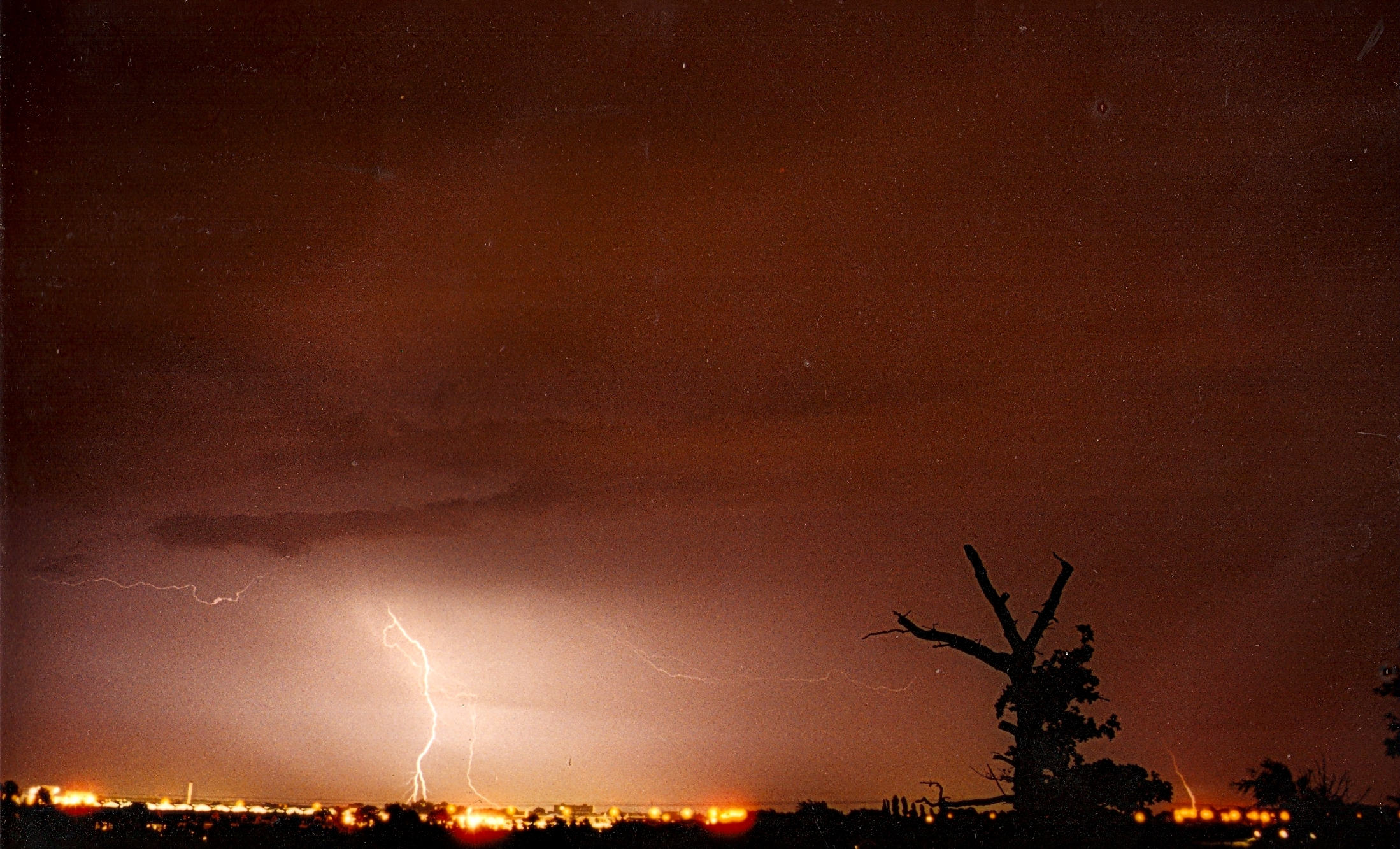
I’ve decided to cobble together a few lines on last night’s notable thunderstorms which reminded me so much of the stormy nights on the 1980s.
The radar at 3am, produced by the excellent Home and Dry, revealed that the storm’s rainfall was quite widespread. The white areas show the most intense rainfall
After writing off the risk of storms for our area last night I was awoken at 3am by loud, rumbling thunder – the kind that seems to resonate all around you. A quick look on the radar revealed quite a widespread thunderstorm, quite different from the smaller, more intense one that woke up most of Wanstead on July 23rd last year.
On viewing the live lightning map at 3.10am it became clear that this was no flash in the pan. Further rumbles and strikes had me leaping out of bed to monitor the station. EssexWeather reported 1809 lightning strikes in two hours for our region.
And on viewing the pressure graph the first storm saw a 6mb fall in pressure in a matter of minutes.
A second storm around 5.30am was less severe though still notable. The 9.4mm that the weather station recorded fell at a rate of 45mm/hr at 3am and 40mm/hr at 5.15am. Though the AWS is often out in heavy rainfall situations on this occasion it was more or less spot on – my 10am reading of my traditional 5″ raingauge revealed the official total to be 9.3mm. The rain took the July total to 108% of the 1981-2010 mean.
And a squall that blew through just before 4am is well portrayed on this wind graph.
So, all in all, a really lively sticky night where the temperature didn’t fall below 18.2C. I didn’t manage to get any of my own pictures but this one by @justinstokes on Twitter caught my eye.
According to the CAPE / lifted index further storms seem likely tonight. Indeed the situation across the Channel could be dire. It is probable a few will trundle their way across the sea to give us another sleepless night…
This wind graph shows a gust of 22.8mph at 0336z in my sheltered gardenRadar at 0519 shows another white blob (very heavy rain) about to cross Wanstead
This pressure trace shows the fall in pressure of the two thunderstorms that crossed our regionLive lightning map from http://www.lightningmaps.org/realtime at 3.10am
The Met Office, earlier this week, warned us that extreme summer rainfall may become more frequent in the UK because of climate change. The research, produced in collaboration with Newcastle University, says that while summers are expected to become drier overall intense rainfall producing serious flash flooding could become several times more frequent.
I hadn’t thought much about the story until, as part of my attempt to find out what this summer is going to turn out like, I discovered some fascinating details of several events during the summers of 1811 and 1828. Many have remarkably similar characteristics to the Boscastle flood in 2004 – the kind of episode the Met Office tells us could become far more common by 2100.
The entries for 1811 in Luke Howard’s book The Climate of London once again shows that extreme weather is nothing new and serious flash flooding was actually more common all those years ago.
May 20 1811 A severe thunder storm came on at Ingatestone, Essex, accompanied with a deluge of rain. In ten minutes the water ran about three feet deep in the streets. The same night at Potter street on the road to Newmarket hailstones nearly as large as pigeons eggs fell accompanied with the most terrific thunder and lightning.
May 27, 1811 Hereford: We were visited by a dreadful storm of thunder and lightning accompanied by torrents of rain very destructive eastward of this city. It commenced about three o’clock in the afternoon and continued with little intermission till past eight. This storm and the consequent inundation of several thousand acres of land destroyed a number of lives and much property.
June 8, 1811 A severe storm of rain hail and lightning took place in Birmingham and the neighbourhood. The hail or rather pieces of ice which fell are described as of prodigious size and considerable damage has been done to the windows. Worcester this day another most tremendous storm of thunder lightning and rain took place about 11am equal to that of the 27th except the hail.
A storm was also experienced June 28 at Bury and its neighbourhood. The lower part of the houses were filled with water which lay in the street 5 feet deep. The hail stones 5 8ths of an inch in diameter broke near five thousand panes of glass. About twenty six head of cattle were killed last week by the lightning at Bisby and Walsham in Norfolk.
July 2, 1811 In the neighbourhood of Wonersh near Guildford after one of the most sudden strokes of thunder a deluge of rain took place so instantaneously as to carry away or destroy every thing which impeded its progress. The damage is estimated at not less than 1,500.
July 21, 1811 A heavy fall of rain did much damage at Stamford. In the meadows about Barrowden, Wakerly, Harringworth, Thorpe, Caldecot and Bringhurst immense quantities of hay were carried away. Several thousand loads it is supposed have been destroyed in addition to which the injury sustained by the land has been very great. The water rose thirteen feet in less than four hours in Wood Newton parish.
View from Greenwich Observatory toward the Royal Naval College
In 1828, a spring that was also similar in terms of temperature and rainfall to this year, more entries in Climate describe flash flooding events.
July 8, 1828 Extensive rains on Tuesday afternoon the 8th instant about four o’clock a storm of wind rain and hail accompanied with thunder and lightning broke over the town and neighbourhood of Taunton with a degree of violence never before remembered by the oldest inhabitant. The thunder in heavy peals was heard simultaneously from the east and west and the wind at one period of the storm blew a perfect hurricane. At Kingston the banks were thrown down for several miles and three rams the property of Mr Welch valued at thirty pounds were killed by the lightning. The corn is sadly levelled by the storm. The hailstones were of uncommon thickness and in their descent destroyed much glass in the windows of private dwellings and outhouses. Various statements of mischief have reached us from our correspondents for many miles round all representing the storm to have been of unqualified violence. Taunton Courier
The inundations occasioned by the constant heavy rains in Flintshire and Denbighshire have proved most injurious and in some instances destructive to the iron works in those counties. The Coed Talon works belonging to the Welsh Iron Company have sustained very considerable injury, the bridges, dams and culverts belonging to those works were all carried away by the tremendous torrents and bursting of the springs. On Thursday night week the waters in the immediate vicinity of the works rose to the extraordinary height of 22ft above their ordinary level and in a few hours extinguished the furnaces such was the impetuosity of the flood and the influence of opposing elements of fire and water that the most serious apprehensions were entertained that the furnaces would have been blown into the air.
The Met Office says summer deluges and intense rainfall will become more common
Happily the buildings sustained the shock and no lives have been lost. It is stated by the oldest inhabitants in the neighbourhood that such awful effects from impetuous torrents were never before witnessed by them. Throughout a great part of Oxfordshire and Worcestershire the wheat and barley have suffered considerably by the late heavy rains Friday afternoon, a solitary dark cloud passed over the north end of Winchester towards the valley of Itchen Abbas the sun shining from the opposite part of the horizon. The spot whereon the cloud appeared to rest seemed to be enveloped in total darkness whence shot a stream of electric fluid accompanied by a short but tremendous crash of thunder and hailstones of considerable magnitude. So violent was its force that it killed two fine horses belonging to Mr Twitchen of Itchen Abbas and struck the carter to the ground where he lay in a state of insensibility for some time, his frock was singed by the lightning. About the same time a cottage occupied by the shepherd of Mr Twitchen s brother at Mitcheldever experienced its violence by being greatly shattered and the shepherd’s wife struck instantly dead. During the same day three horses belonging to Mr Budd of Hatch Warren Farm, near Basingstoke, were struck dead by the electric fluid and a man who had charge of them was so dreadfully injured as to render recovery hopeless. Bath Chronicle
The list goes on… I’ve had a look at all summer rainfall since 1797 to see if 1811 and 1828 were particularly wet years but the records I have, taken by Luke Howard at Stratford, are nothing out of the ordinary.
The summer of 1811 in London saw a mean temperature of 16.1C (1.5C cooler than the current 1981-2010 average) while rainfall was 211mm (just under 150% of the current average). The summer of 1828, however, was warm for the period – at 17.5C. Rainfall was high at 317mm (218% of today’s summer average). Of course totals in the areas affected in the articles would have been much higher.
So when the Met Office says climate change is going to bring more flash flooding in summer I wonder if it is the climate cycling back to a period where we’ve seen it all before.
This graph of summer statisitics shows a regular series of peaks and troughs for rainfall. The mean temperature is generally 1C warmer than it was 100 years ago
*For those interested below is a continuation of summer flooding events that plagued the country in 1811, 1828 and possibly many other events of records we have probably sadly lost.
Sussex The accounts from the western part of this county both on the coast and in the weald concur in stating that the effects of the thunder storm of the 3rd instant were most severely felt. So severe a storm has not been experienced since 1821. The storm on the evening of Thursday night was most violent in the neighbourhood of Chichester and lasted from eight in the evening till nearly four in the morning, the electric fluid entered a cottage at Birdham and shivered a bedstead rolling its occupier with the bed on the floor lut who escaped without injury. Brighton Herald
The almost constant rain which has been experienced in Penzance and its neighbourhood has been very detrimental to the hay harvest West Briton PL
July 10, 1828 We regret to state that the floods in this neighbourhood still continue and the waters indicate by their colour how great the mischief is amongst the hay. The Welland and the Nene are of the hue of strong tea proceeding from the essence of the hay which is entirely washed out of whatever was not stacked before the 10th instant. – Stamford Mercury
Cambridge The late heavy rains in this part of the county have laid and much injured the corn crops and likewise considerably impeded the hay harvest Bury Herald
July 17, 1828 Sheffield In our last publication we alluded to the long continuance of hot weather which had been experienced in this neighbourhood. On Tuesday, however, a change took place and on Wednesday the rain fell more heavily and incessantly than it is remembered to have done at the same season for several summers past. Indeed not only were our two rivers remarkably high but the springs of many wells which had failed at the usual time experienced a temporary refluviation. Sheffield Iris, July 17
Malton, July 17 Every hour brings fresh accounts of the extensive losses sustained by the occupiers of land bordering on the Rye and Derwent. Hay has been floating in swarth and in cock of all sizes and the loss in various kinds of grain and potatoes is incalculable. Such a weight of rain and such a flood were never known at this season of the year. On Sunday morning last Sunderland was visited by a thunder storm. The lightning was remarkably vivid the peals of thunder were tremendous and the rain fell in torrents. The Wear was also much swollen. Great quantities of hay came down the river. From our correspondent at Durham dated Sunday afternoon: Since early on Saturday morning Durham and the neighbourhood have been visited with a succession of heavy rains insomuch that the river Wear is swollen to a dreadful height and has done and is still doing frightful damage to the adjacent fields which are overflown to the extent of many hundreds of acres many of which are meadow some just mown some in pike and some standing uncut – Tyne Mercury PL, July 17
Doncaster, July 19 I have within a few days been over a considerable tract of land in this and the adjoining county for the purpose of ascertaining the effects of the late floods on the crops. A great portion of the country through which the Derwent runs as well as the other rivers which empty themselves into the Humber has been overflowed to a very considerable depth and the consequence has been the complete destruction of the greater part of the grass which was cut and those crops which were not cut will not be worth the trouble. We regret to state that in this town and neighbourhood the weather has continued extremely unfavourable throughout the week. Scarcely a day has passed in which we have not been visited by heavy falls of rain accompanied in some instances with thunder and lightning. We have not heard of any further injury being done in the vicinity by floods but we fear that the wheat and other crops as well as fruit and vegetables will suffer greatly from the long continuance of wet weather. – Manchester Mercury PL, July 20
Although within the last few days several thunder storms have fallen in this immediate neighbourhood we have not heard of any serious injury to life or property. On Wednesday week 9th at Great Houghton during a thunderstorm the lightning descended through the sky light which it destroyed in the roof of Mr Brook’s house and through the ceiling into an upper apartment and shook down the tester of the bed on which Mrs Brook was reposing without, however, inflicting any injury further than the alarm into which she would naturally be thrown. Its course was then along a passage in which there was a cupboard whose contents of glass and earthenware were partly demolished and the door of the cupboard dashed along the passage at the extremity of which was a young female who happily escaped unhurt. – Doncaster Gazette PL, July 21
Newark July 21, 1828 You cannot possibly have an idea of the effects of the late stormy weather and the consequent inundation of the large tract of country unless you were to see it. All the country from this place situated on the banks of the Trent down to the Humber has been completely overflown and has borne the appearance of one expansive sea.
Bedford July 22 In consequence of the dreadful and continued rains every thing in the neighbourhood of this town is in the most frightful state. The Ouse has overflowed its banks in every direction as well below as above the bridge and for miles nothing is to be seen but a weary waste of waters with islands of hay or haycocks. The early season for hay gathering in the northern counties was favourable in the extreme and a great quantity of hay out of the abundant crop was secured in capital condition. About the middle of the last week the barometer sunk rapidly and torrents of rain fell day after day till the rivers became swollen and on Sunday and Monday last vast tracts of land particularly in the southeast part of this county extending from Doncaster to Hull were inundated. Even in the neighbourhood of Wakefield the hay was seen floating in the fields and near Barnsley a great deal was either washed away or rendered useless except for litter. The corn crops have also been much beaten down by the heavy rains and potatoes in low situations have suffered from the floods. – Leeds Mercury
Whitby From the 8th to the 13th instant a succession of heavy rains has been experienced at Whitby and its neighbourhood which did considerable damage to the bridges on the Esk. On Sunday morning the platform of the elegant suspension bridge at Ruswarp belonging to James Wilson Esq MP was wrenched from its abutments and together with the cast iron pillars was thrown into the stream. The small stone bridge recently erected by Edmund Turton Esq on the new line of road was also carried away likewise a bridge at Cock mill and another in the neighbourhood of Egton. The neat bridge at East Row has been so far injured as to be passable only by foot passengers. Great quantities of timber, hay were washed away and the fields and gardens completely flooded. From all parts of the country accounts pour in of the disastrous effects produced by the late uncommonly heavy rains. From Ganstead and Withernwick in Holderness to beyond Driffield a distance of from twenty five to thirty miles the country presents an almost unbroken sheet of water. The quantity of hay corn and potatoes destroyed and likely to be so is beyond all calculation thousands of acres of the latter are literally rotting in the ground. From Doncaster down to Gainsborough and the low grounds at the junction of the Ouse and Trent the inundation is stated to have been still more destructive than in this immediate neighbourhood. – Hull Advertiser
The south western districts of Scotland appear to have been visited by the same excessive quantity of rain that has been experienced so generally over England. It would appear, too, that the crops there are in general good and that the wheat in particular promises to turn out better than in the south July 30.
August 1828
Deal Aug 9 The wind has blown very hard the whole of this afternoon at intervals almost a hurricane. Wind WSW
Brixham (Torbay) Aug 9 At three o’clock this morning it came on to blow quite a hurricane from the SSW and continued unabated until four this afternoon since when it has been more moderate.
Falmouth Aug 9 It blew a heavy gale here last night and continued until noon this day from the SSE to WSW
Penzance Aug 9 The wind has blown a perfect hurricane from SW all this morning. Accounts of damage.
Noon. PL The storm still continues with unabated fury. Great numbers of trees have been blown up by the roots and many mows of corn in the fields are quite upset and the sheaves blowing about in all directions PL
The Thames was higher on Wednesday last than has been known at this season for twenty seven years. All the low land about Goring Pangbourn Mapledurham, Caversham, Sonning &c was under water. – Berkshire Chronicle
Over the years significant weather events have, at least in my subconscience, at times signalled that something ‘big’ is about to happen – just one example being the Great Storm in October 1987 that was followed days later by the Black Monday stock market crash.
So an event that happened 100 years ago this month, to some, probably also brought a feeling of impending doom as the political situation in Europe became ever more fraught.
Account of the thunderstorm reported in The Times
A series of severe thunderstorms that broke out just after midday over south-west London on June 14, 1914, left people dead and a trail of destruction across areas south of the Thames. Fierce lightning, torrential rain, severe flooding and hail ‘the size of walnuts’ accompanied the storms. Six people were killed by lightning on Wandsworth Common and four others were injured. As with many thunderstorms the heaviest rain, 94mm in 3 hours at Richmond Park, was focused over a small area. South Kensington, just over 5 miles away, recorded just 6mm! I don’t have the figures for Wanstead but judging by the map published in the 1914 edition of British Rainfall it probable recorded even less than South Kensington.
Some reports by observers.
Dulwich: Violent hailstorms. Many hailstones were like acid tablets about one inch long, half an inch broad and over a quarter of an inch thick. A minute or two after these had fallen, a mist rose to a height of about 4ft above the ground.
Lewisham: A storm began at 12.24pm and came right overhead from the east with terrific flashes of lightning and loud thunder. At 12.31pm, rain fell with extraordinary fury; within 9 minutes 0.5 inches had fallen. The second storm came up just after 1pm, the lightning being even more severe. At 1.30pm, St Mark’s Church, and the Holy Cross were struck. A tree in Hither Green cemetery over 30ft high was splintered and two houses were struck at Catford. Another thunderstorm came up at 2.25pm with torrents of rain and hail as large as haricot beans fell for 5 minutes.
Rainfall in the London area – June 14, 1914 – shown in the publication British Rainfall
Richmond Park: Very severe storm passed over the house; an oak fence was struck by lightning in two places. Rainfall measurements were as follows: 1.80 inches in 45 minutes, 2.70 inches in 90 minutes, 3.2 inches in 2 hours, 3.60 inches in 2.5 hours, 3.70 inches in 2.75 hours.
Wimbledon Downs: There was a curious scene close to Kingston station, where the water was about 4ft feet deep at five o’clock and motor cars and omnibuses had to make a wide detour. The storm was especially severe in Wimbledon district, where, owing to the bursting of an overtaxed sewer, the District Railway line was submerged. At Tooting Junction station was a foot deep on the platform.
Judging by the 1881-1910 average 1914 was a warm year: the mean temperature of 10.7C was a full degree warmer than average. It was also 15 per cent wetter than average and the sun hours were nearly 108% of average. Of course by today’s standards (the 1981-2010 average) 1914 looks relatively cool as the average annual temperature has risen 1C in the past hundred years.
The weather on this day must have been synonimous with the deteriorating political situation in Europe: two weeks later Franz Ferdinand, Archduke of Austria, and his wife Sophie were assassinated in Sarajevo by a young Serbian nationalist Gavrilo Princip , the casus belli of the First World War.
What is fascinating is that a similar thunderstorm that left seven dead in Valentines Park, Ilford, 75 years ago this August, also happened about two weeks before Prime Minister Neville Chamberlain announced on September 3, 1939, that Britain was at war with Germany.
The last time January was so wet Eddie ‘The Eagle’ Edwards was about to fly the flag for Great Britain in the ski jump at the Winter Olympics in Calgary, Canada, in 1988.
There was occasional respite from the persistent rain
Some 130.6mm of rain (251% of average) fell in January, beating the previous record set in 1988 by just 2.8mm around midnight on Saturday 1st. Unlike 1988, last month followed a December that was 154% wetter than average. The wet spell, which started on December 13th, is only now making a real impact on the river Roding which is now running very high.
January was also warmer than average with a mean temperature of 6.4C (1.5C above the 30-year average) – ranking it 20th in the series since 1881 – and the warmest January since 2008. Though the month was very mild no single day was particularly mild. Highest maximum was 12.7C on the 7th.
The most notable day was probably Saturday 25th when what started as a bright, fine day quickly changed around 4pm as a strong squall with heavy rain blew through with associated thunder and lightning and 6C fall in temperature in an hour. Wanstead escaped the damage of elsewhere. Numerous trees blocked rail lines in Kent and gusts of over 60mph were widely reported.
There were two other incidents of thunder and lightning on 5th and 6th – very unusual in the middle of winter and an average normally observed in high summer.
Air frosts: 5 : coldest night of winter so far was observed on morning of 12th with -2.9C
One of the worst weather-related tragedies ever to hit the London area happened 86 years ago this month.
What started as a bright and sunny day in Valentines Park, Ilford, turned into disaster at ten minutes to five on Monday, 21 August 1939, when lightning struck a corrugated iron shelter where about 30 people, many of them children, had taken cover from a thunderstorm.
Seven people, including five adults and two children, were killed and 21 injured in the incident near an open air swimming pool where earlier families had been enjoying picnics.
The event was recorded in The Times the following day: “About 5 o’clock there was one final flash, followed by a deafening crash. Everyone in the shelter was thrown to the ground and rescuers who had heard the cries of the injured found them piled in a heap. One of the two women killed had most of her clothing torn off. A man was lying dead on the cross-bar of a cycle. A woman at the back of the shelter was lying unconcious with her arms round two screaming children.”
Looking south-east across the cricket pitches, and the site where the open-air swimming pool used to be, to where the tragedy is believed to have happened
A survivor of the tragedy, Mrs H. Treves, of Barkingside, told how she had gone to the park that day with her two daughters, June, three, and Shirley, seven, for a picnic. She told The Times: “Suddenly the storm broke, and we ran for the shelter. Inside there were about 30 people, and we were all huddled at the back away from the rain. I sat on a bench at the back of the shed with June in my arms and Shirley by my side. Suddenly I was flung from the bench. I must have been stunned for some minutes, because when I came to I found Shirley lying beside me and the ground heaped with people who seemed unconscious. I heard June whimpering, and eventually found her beneath three or four people. One of the men lying across her was dead. I escaped with only burns on my side. June had burns to her foot and Shirley burns on her shoulder and foot.”
One woman told how she had a lucky escape. Mrs A. Galey, of Ilford, said: “I stood in the shelter for about 20 minutes, and then something inside me urged me to leave. I had got about 50 yards when there was a flash and I felt numb. I turned around to go back to the shelter, and then saw all the people huddled on the ground. It looked like a battlefield”
Among the injured were a number of electrical workers who had been repairing a cable which ran through the 150-acre park. Neither the hut, which measured about 20ft by 12ft and had a sloping galvanised iron roof, or the two trees immediately behind it, were damaged.
The disaster was reported in the local paper The Recorder three days later
The local paper, The Recorder, reported the horrific scene that unfolded moments after the strike. It describes other park users frantically trying to help the stricken people in the shelter. One of the first on the scene was Mr A.B. Rowe, an A.R.P warden, from Romford. He said: “I was coming from the pool when a boy ran up and said ‘They have been struck’. I went over and found a heap of people, some terribly injured, in the shelter. During the war I saw some terrible sights, but none more horrible than this. Many were terribly burned and others were twisted into all kinds of positions and unable to move.”
Another helper was Mr H.G.B. Goater, of Eastern Avenue, Ilford. He had also been to the pool and was attracted to the scene by the screaming. “It was like a battlefield. I have seen nothing like it. The dead and injured were in a heap in the shelter.” Mr Goater spent several hours going back and forth to King George hospital with his car, first taking the injured for treatment and then waiting to take home some of those who were allowed to leave.
Among the dead was Dorothy Cribbett, of Capel Road, Forest Gate. She had taken shelter in the hut and was waiting for her 11-year-old daughter, Peggy, to join her when the lightning struck. Her grandson, Ian Braithwaite, 44, whom I managed to track down while researching this piece, takes up the story. “As my mother was making her way from the pool to the shelter lightning struck a bicycle that was leaning against the shelter – leading to the deaths of the people.”
Ian, who now lives in Auckland, New Zealand, commenting on the original article, said: “It makes for very grim reading and was far worse than I remember my mother ever talking about. I know my mother found my grandmother dead in the park and for anyone, let alone an 11-year-old to find someone in the condition that was reported must have been absolutely horrendous.”
He added: “It is one of those stories that you think must be made up, especially as I am drawing on childhood memories from over 20 years ago. Also my own mother died when I was 14 and I have no other known relatives from her side of the family. But I remember her telling me that is what happened.”
He continued: “It seems like it was a pretty miserable time for my mum back then. She was only 11 when her mother was killed and when the war started her father took her to Devon where he came from. In 1943 her grandfather was killed in a bombing raid on Torquay by the Germans. In the same raid a bomb was dropped on a nearby church killing 20 children at a Sunday school service. And we think we have it tough today.”
Ian has been trying to piece together memories of his mother and said: “I am hoping that someone may be able to give me more information surrounding this event or if anyone knew my grandmother or my mother. My grandfather’s name was Ernest Charles Cribbett.”
The synoptic chart from the Air Ministry (forerunner of the Met Office) for Monday, August 21, 1939
The violent storm, in what up to that point had been a mostly cool and changeable summer, brought flooding to areas around the town and several properties were struck by lightning. Whole chimney stacks were brought crashing to the ground when houses in Selborne Road and Courtland Avenue were hit. Another resident in Woodlands Avenue, Ilford, described the moment before their chimney stack crashed into their living room. “There was a blinding flash and a great crash. We thought the house was going to cave in on us: it seemed as though a bomb had dropped on it.”
The storm also affected the Barkingside area. As the rain fell in torrents a chimney stack on two houses in Tomswood Hill was struck by what an occupant of the house described as a “ball of fire that crashed on to the roof and came zig-zagging though the front room and out of the scullery door”.
Elsewhere in London severe flooding in Ealing is mentioned in The Times. And large hailstones were reported in Surrey.
Rainfall in thunderstorms varies greatly – and this storm was no exception. Met Office rainfall data from the day shows that Loxford Park, the closest rainfall station to Valentines Park about a mile to the south-east, recorded 30mm – almost double that of City of London Cemetery, just over 1.5 miles to the north-west of the storm’s centre, which recorded 15.7mm. In view of the rain and the lightning strikes which happened less than a mile away, across the River Roding, Wanstead had a lucky escape that day.
This selection of newspaper bills, produced by Mike Ashworth, shows a media fixated with build up to the start of WW2 while the Daily Sketch and Daily Mirror focused coverage on the horrifying event in Ilford
While researching this I found it strange that local memory of the incident is very vague. The oldest generation of my family, a few of whom lived off Ilford Lane, cannot recall the incident though I believe quite a few had already moved out of London as part of the evacuation before the Second World War. Perhaps it is also possible that while this incident by today’s standards is horrific it pales into comparison with what was to come just over a year later with the start of the Blitz in September 1940 – which would result in the loss of thousands of lives in the East End and across the UK.
The disaster in Valentines Park equalled the number of deaths of those under a tree on Wandsworth Common in 1914.
Other deaths caused by lighting in London include two women who were killed while walking in Hyde Park in September, 1999.
According to TORRO, the Tornado and Storm Research Organisation, about 30-60 people are struck by lightning each year in Britain of whom, on average, three may be killed. You can read further on lightning impacts and safety tips to avoid getting struck here. The Met Office also features a page of lightning advice.
I would like to thank Redbridge Central Library for their help in accessing the archives for this piece. And to Mike Ashworth who kindly gave permission to use the superb newspaper bills montage. You can see Mike’s work at his Flickr site. Thanks also to the Met Office.


 With so much rainfall overall sunshine was affected with only 451 hours recorded, just 80 per cent of what can be expected in an average summer.
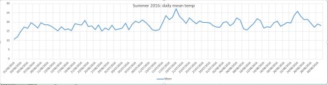


 actually trumps 200 years ago; the running total for rainfall here is 390.1mm, higher than the 309.6mm recorded in 1816.


You must be logged in to post a comment.