Geoffrey Prater served in the 51st Royal Tank Regiment during his five years’ national service and saw action during World War II in Italy and North Africa.
I met the 91-year-old Wanstead resident earlier this year after my article on the Blitz prompted him to write to the editor explaining what life was like during the war 75 years ago.
Over a cuppa we spoke at length of how he and his family coped with the Blitz. Carefree days spent playing over Wanstead Park and Wanstead Flats were brought to an end in September 1940 as the Luftwaffe’s bombs started to rain down. In November 1940 Geoff lost his elder brother, Doug, during an air raid in Stratford.
He was called up for national service in September 1942 and, after a year of training at Brentwood, Farnborough and Barnard Castle, his regiment set sail from Liverpool docks in December 1943. Five days on mountainous seas, through the Bay of Biscay, ended with arrival in north Africa on Christmas Day from where he was posted to Italy to fight the Axis.
On returning from Italy Geoff had to come to terms with the fact that his family home in Devonshire Road, Leytonstone, had been destroyed by a V1 doodlebug bomb. His mum and younger brother, Dunc, who only narrowly escaped the bomb, had to move to a flat above a shop in Chobham Road, Stratford.
Geoff has written an account of his experiences during World War II. It’s an absolutely fascinating read and is available both in paperback and download here.
I feel privileged to have met Geoff. We owe so much to his generation’s fortitude and courage in the face of adversity.
In his own words, from the introduction of his book:
“Most people of my generation are proud to have been part of those momentous days, whether in the Services, or at home. They all suffered the grim hardships that existed at that time, with determination to see it through, whatever the cost. So, next time you see some old boy, walking down the road wearing his medals, usually at November time, don’t say, ‘Look at that silly old fart’. Just respect his pride in wearing them, after all he might be one of those ‘old boys’ who saved your way of life.”
It was just before 3am that I was awoken by faint rumblings outside. I knew there was a risk of thunder before I’d retired to bed a few hours earlier but I’d discounted the risk along with any thoughts of staying up to watch the referendum results unfold in Scotland.
This radar shot shows the storm just beginning to hit Wanstead. The rain was far heavier to our east. 17.2mm was reported at Laindon, Essex. An observer at Woodford Wells recorded 19.9mm her in about 25 minutes 0310-0335 bst
Lightning then illuminated the room through the gaps in the curtains followed by more rumblings: it’ll pass, I thought. Crash – I grabbed my phone – was this an isolated event? The radar showed a line of slow moving storms moving up from the south. More lightning and loud thunder. My Twitter feed told me it wasn’t going too well for those wanting independence. At this point intensely bright lightning was rapidly followed by one of the loudest claps of thunder I’ve heard around 3.10am. Car alarms were set off – may as well get up I thought… The Inverclyde result was announced – ‘No’, by the narrowest of margins 50.1% to 49.9%. That’s it then, I thought. The lightning and thunder gradually began to fade away with hopes of an independent Scotland, on this night anyway. I glanced at my stats which seemed far less impressive than what was recorded elsewhere: 7.7mm, no big fall in temperature or pressure like previous storms during the summer.
Just a few hours later I walked my younger daughter into school, my bleary eyes struggling to focus – the humid and steamy atmosphere felt more like July than September. Indeed Thursday had been the warmest September 18th since 1997 which, strangely, was the same year that another momentous British event took place: the handover of Hong Kong to China. I remarked to a couple of parents that the only thing that had changed overnight was that Andy Murray will forever be the “Scottish” tennis player after his comment on Twitter.
The forecast advised that there was a continued threat of thunderstorms. It was humid but it didn’t ‘feel’ stormy – though around 2.30pm I could hear the beginning of faint rumblings in the distance.
Clouds above could be seen developing rapidly at 2.30pm
I left for work on my scooter at 3pm, carefully watching the sky for any developments all of which seemed to be in the distance. After stopping for petrol in Leytonstone High Road huge drops of rain began splattering the pavement. They were few and far between, however, and the sun defiantly continued to shine. After riding past Stratford I suddenly became aware that the buildings in the distance, past Bow flyover, were gradually beginning to disappear. I pulled in to a turning where Gala Bingo is situated. An electronic noticeboard enquired: “Do you feel lucky?” Not today I thought and retrieved my overtrousers that live under the seat, hastily pulling them on as I watched the impending storm begin to close in.
I continued on and was soon enveloped in the full force of another thunderstorm. Marble-sized hail clattered off my crash helmet while dangerous gusts, caused by wind funneling through the new high rise flats by the Olympic Park, did their best to push me off. Just as I crossed the canal a sheet of rain engulfed me and the drivers to my right. The road in front suddenly turned into a shallow river. I usually ride over the flyover – not today with the torrent of water cascading off the sides.
The 3.15pm storm that flooded large parts of East London. The white area shows where the heaviest rain was
By the time I reached Mile End the rain had almost stopped. The City looked fairly dry and on reaching London Bridge the roads were completely dry. The Friday crowds were out in force in Borough Market, enjoying the sunshine and seemingly oblivious to the chaos unfolding just a few miles away in East London. Within 10 minutes of walking into my office Alex Salmond announced his resignation. Another storm: another momentous event! It was another of those coincidental storms that, in my mind, seem to mark momentous events such as the Royal birth last July
I checked the stats of the storm back in Wanstead: 24.5mm fell with a peak rate of 76.5mm/hr at 15.47. The storm ended a run of 16 dry days bringing the total for the month up to 33mm – the 24hr total was 30.5mm. The explosive convection of this storm can be seen here. The associated hail and rain brought much flooding to Hackney, Hackney Wick and Leytonstone. This storm seemed to be the result of a convergence line over London between light southerlies to the south and easterlies to the north – the heavy rain was very localised.
The flooding wasn’t restricted to East London. In Southend water started pouring through the roof of the Dixons theatre though it failed to stop the performance. Shops in London Road were inundated.
At the beginning of May I had a look at the March and April stats to try to decipher what the coming summer would be like. The results still suggest that summer will be a mixed bag weather-wise with only brief hot spells interspersed with humid thundery breakdowns and cool, cloudy and showery regimes.
The third warmest March-April period since 1799 possibly prompted some weather ‘experts’ to claim that we’re heading for a hot summer. But converse to what the Daily Express told us in April I cannot see any signs of a ‘hottest summer ever’. And it should be remembered that this rag also warned us that the past winter would see ‘100 days of snow’. In the event I think 100 days of rain was probably more true, and I would like to point out at this juncture that my own winter forecast was hopelessly out, along with many others.
To reach my conclusion on this summer I have used pattern matching of meteorological data for March, April and May stretching back to 1799. The mild and dry weather of March and April has been tempered by the wet May. The mean for the spring season was 11.7C with 116.4mm of rain and 473 hours of sunshine. If you take into account all years that were within +/- 10 per cent of these figures you get the following table.
When considering the data I first extracted the number of similar years by rainfall. Of these I then discounted any that were not within + / 10 per cent of the spring 2014 mean temperature.
The ‘best fit’ years were revealed as 1811, 1828, 1871, 1882, 1912, 1945, 1959 and 1989. Using sun hours similarities this could be narrowed further to 1912, 1945, 1959 and 1989, however it should be noted that I don’t have sun hours data prior to 1881!
Or, expressed in probabilities, I concluded the following:
Summer probabilities
So from the above you could deduce that the next three months will be average to rather cool, with average to slightly below average rainfall. Sunshine below average.
Trying to predict details over the next 3 months is impossible, but looking at the ‘best fit’ years mentioned above a warm spell happened without fail between the dates June 18th – June 22nd. Other dates to bear in mind for possible fine spells are July 5th, July 12th-15th, July 22nd, August 4th and August 20th.
* Taking into account the fact that temperatures in London are up to 1C warmer than they were 100 years ago I have added 1C to mean temperatures before 1915.
** Obviously, in the event of a series of direct hits from thunderstorms, my rainfall estimate could be hopelessly short – a symptom of abundant solar energy at this time of year which creates a ‘noisy’ atmosphere compared with winter.
*** The 1981-2010 average mean for summer in this region is 17.6C, with 144.9mm of rain and 564 hours of sunshine
Winter 2024/25, considering the DJF mean, sits 68th out of 79 winters back to 1946/47.
It was the 13th snowless winter in the series . The only ‘top 10’ winter for snowfall of the past 30 years was 2009/10!
Snow is a very rare commodity in lowland Great Britain – even rarer in the Home Counties, and in our part of east London. Pulling back the curtains on a cold winter’s morning to be greeted by a fresh fall of deep, crisp and even snow is something most children experience and hold dear for life. The slush, ice and chaos that inevitably follows all too quickly is forgotten.
My memories of winters in the 1970s and 1980s is that they were far snowier and colder than they are today. But were they *always* cold and snowy? I decided to have a look back through the archives to find out. My first stop was the Met Office’s now defunct Snow Survey of Great Britain. This excellent compilation of reports logged by observers nationwide was printed annually as part of British Rainfall. But through lack of interest and cuts printing ceased after the 1991-92 season. Data continued to be collected though the modern version of the survey uses satellite technology to estimate daily UK snow depths – the Met Office website says that this is far less subjective than an individual nipping out at 9am every morning to ‘stick in a ruler’ and, those within sight of high ground, to observe where the snow line is. This does a disservice to the hundreds of observers who down the years diligently logged all their information as objectively as possible. But on to the data…
Regional data was not included in the survey until the 1965-66 season. Though Wanstead isn’t listed I have taken an estimate from data supplied from stations at Eastcote (53m), East Barnet (70m), Charlton Park (46m), Twickenham (13m), Teddington (9m). Because this area is influenced by Thames streamer snowfall that blows in off the North Sea and is funnelled upriver I have also considered readings from Epping (107m), Rayleigh (73m) and Southend (27m). Indeed, in some years Wanstead’s snowfall is much more similar to Rayleigh and Southend than it is to Greenwich and Teddington. Though my site is only 18m it seems to catch the snow much better than surrounding areas – probably to do with the fact that Aldersbrook is surrounded by greenery. People walking down from Wanstead village often remark that Wanstead Park is far snowier than the village a couple of dozen metres or so higher. Before 1965 I have used data from Woburn, Bedfordshire, which at 89m and 40 miles away as the crow flies, is the closest station in that long running series.
The mean temperature of a winter can look cold but it doesn’t always tell the full story. You can have a winter dominated by high pressure over the near continent making things very dry. But the anticyclones that ridge from Central Europe to the Azores can leave us in the ‘warm’ part of the high – and often lead to days of anticyclonic gloom; cold grey, dank and boring weather with little sunshine. On paper a season can look cold but in reality totally unremarkable; it is the number of days with ‘snow lying’ that people remember. For snow to settle it needs to be cold! For this reason I haven’t bothered with ‘snow falling’ data as it can snow at 4C in very dry air – yet nothing settles. Most weather geeks find ‘snow falling’ the most frustrating when it doesn’t stick. So on to the results.
The Top 20 winters in Wanstead, using ‘snow lying’ and ‘mean temperature’ in stats. Click here to view all 79 winters back to 1946/47
Once I worked out the ‘snow lying’ days I decided to devise a winter index by dividing ‘snow lying’ by seasonal mean temperature. Because the results using Celsius were problematic in that 1962/63 becomes very skewed upwards I decided to use Kelvin.
The results are quite surprising. Coming out top, not surprisingly, is 1962-63 with an index of 25.2 and 69 days of snow lying. Second is 1946-47 with an index of 21.1. Third is 1981-82 with an index of 10.5 – surprisingly ahead of 1978/79, the first winter in the series that I can recall; I remember returning home from school one night in December 1978 and the snow being as deep as the twelve-inch step to our house.
The index of 25.2 for the 1962/63 winter and 21.1 for 1946/47 – over double the amount of 1981/82 – shows how ‘off the scale’ those two winters really were. My father, who doesn’t share my enthusiasm for the weather, can distinctly recall the severe conditions of 1962/63. He said the roads were so thick with snow that when the thaw finally arrived in March he’d become so used to driving on snow that he crashed through somebody’s front garden wall, after losing control of his Mini on surface water sat on the ice.
More recent winters, which pale by comparison, rank surprisingly highly. The 2009/10 winter comes in at Number 10, higher than the legendary 1986/87, where the coldest day in recent times was recorded in London, which came in at Number 12. It should be noted that January 1987, when on the 12th the temperature did not rise above -5.5C all day, was sandwiched by a mild December and February.
Just by looking at winters with a mean of, say, 5C doesn’t tell you much about snowfall. When you look at 1985-86 (mean 4.1C) there were 22 days of snow lying at 9am – yet 2005/06 was colder (3.9C) and only 3 mornings saw snow lying – though that winter was particularly dry – the 13th driest in the series.
The median for ‘snow lying’ days in this series is six. The rolling median of the past 30 years, however, is only 2 so, with this in mind, if it does snow you should get out there and make the most of it.
You can view over 70 years of winters in this area, all ranked using my winter index here.
*It should be noted that a day of ‘snow lying’ only qualifies if there is more than 50% cover at the observation time of 9am. This means that it could snow 1cm at 10am – if that snow thaws by 9am the next day it won’t count. Though 8 winters appear snowless it is possible that these winters did see temporary coverings

 I met the 91-year-old Wanstead resident earlier this year after my article on the Blitz prompted him to write to the editor explaining what life was like during the war 75 years ago.
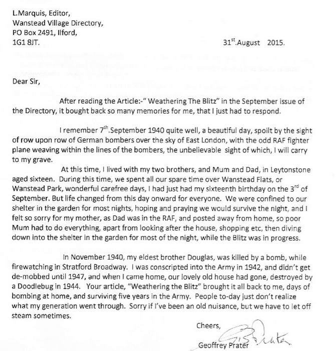 On returning from Italy Geoff had to come to terms with the fact that his family home in Devonshire Road, Leytonstone, had been destroyed by a V1 doodlebug bomb. His mum and younger brother, Dunc, who only narrowly escaped the bomb, had to move to a flat above a shop in Chobham Road, Stratford.


 Just
Just

You must be logged in to post a comment.