June 2014 continued this year’s theme of being milder than normal; the mean temperature of 17.1C was 1C above average, making it the 22nd warmest June since 1797.
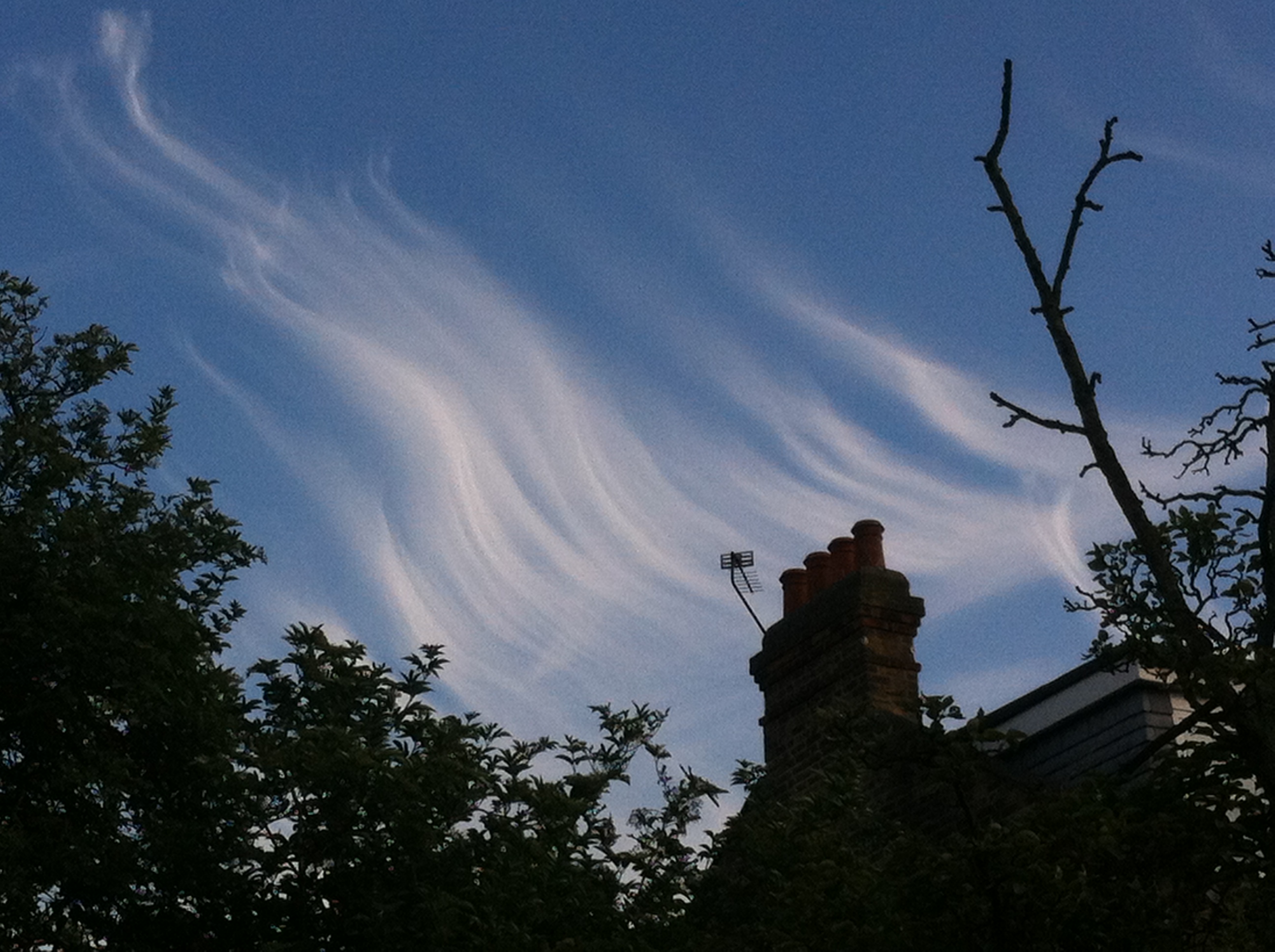
June was marked by some spectacular cloudscapes and sunsets. This was the view across Wanstead Flats from Centre Road looking toward Ilford on the 21st
June, like March and April, was dryer than average with just 15.2mm of rain, that’s just under 30 per cent of average.
The driest June since 2000 started off unsettled with frequent rain – 6mm falling on the 3rd. The following day was cool with the temperature reaching just 16.2C.
Though there were nine days when over 10 hours of sunshine was recorded the magic 80F was surpassed just once: on the 9th when 27.5C was reached under 6 hours of sunshine. This sunniest day was the 10th when 14 hours of sunshine nudged the thermometer to 24.5C. Overall there were 214.1 hours of sunshine – that’s 120% of average, the sunniest since 2011.
On many days during June, including the 30th shown here, the sky turned dark but just spits and spots of rain were often produced
Despite plenty of potential no incidents of thunder were recorded – the much-hyped weekend of the 7th / 8th saw less than 2mm of rain – all of the action staying well to our east in the France, Germany and the Low Countries. Further thundery potential on the 13th failed to produce anything in this area though a disturbance over Berkshire saw thunderstorms develop in the Oxford, Reading, Basingstoke and Wokingham region, with up to 38mm of rain falling over a wide area.
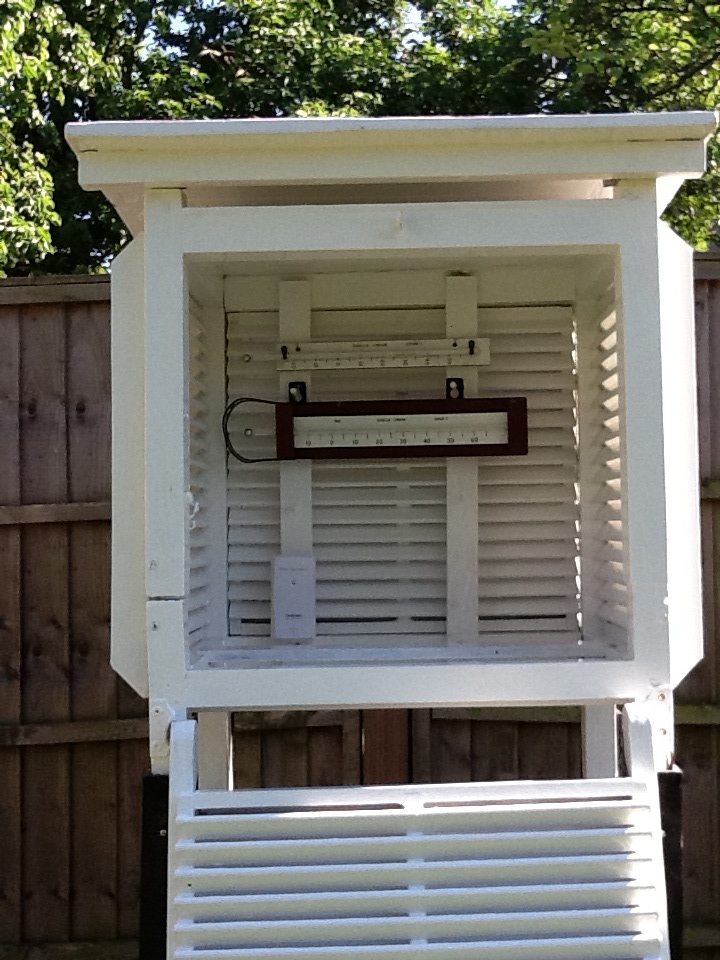
It is a typical feature of summer that rainfall can vary a great deal across a small area. The nearest official station to Wanstead, St James’s Park 8.4 miles to our south-west, recorded 33.8mm – more than double what fell here.
Some nights were chilly when the sky cleared but there was no air frost or ground frost.
Yet another occasion of impressive cloud formation during June included this example of late evening cirrus. The formation, seen at ground level, seemed similar to a display of the AuroraCircumhorizontal arc over Aldersbrook
March 2014 will be most remembered for glorious sunny days that brought welcome relief after a run of seemingly endless wet months.
Many trees blossomed early this year, thanks to the mild winter
It also continued the mild theme of the winter; the mean temperature of 9.1C was 1.4C above average, making it the 11th warmest March since 1797. Looking at my other series back to 1881 the March mean maximum was second only to March 1938!
Just 25.8mm of rain fell over the 31 days – that’s 63 per cent of average.
The month started on the chilly side but with plenty of sun around it felt pleasant. Though many days were warm clear skies led to frost and fog forming. Hail was observed on three days.
The most notable weather occured on the 26th when the temperature fell from 10C at 1.30pm to 4C by 3pm. Heavy showers accompanied what was an utterly foul day. The cold pool persisted into the 27th with towering thunder clouds surrounding Wanstead, north, east and south – with reports of hail in Berkshire and snow in Folkestone.
The month ended with warm, sunny weather – the southerly flow bringing Saharan dust that deposited on cars. There were 4 air frosts and 14 ground frosts.
A southerly airstream brought dust that originated from the Sahara Desert
The Wanstead Weather live Twitter feed is one year old today. That’s over 8,700 tweets of hourly weather updates. In that time there’s been 59 air frosts, 632mm of rain, 165 rain days, 27 days with snow falling, 13 days with snow lying – a total of 14cm falling.
Highest max was 34C on July 22nd, lowest min was -7C on January 16th. A windrun of 25,741 miles shows that the anemometer has turned enough revolutions to have circumnavigated the globe, albeit at an average speed of 2.9mph.
Much comparison has been made of Monday morning’s storm which claimed the lives of four people and 1987. The origin of both storms was down to a combination of a jet streak interacting with a pool of warm air low down. Both storms followed a similar development but clearly 1987 was more optimum. The 1987 storm was slower and further to the west when it developed. This morning’s storm was too much in the jet stream and raced on with less development.
Both the 2013 storm, left, and the 1987 storm followed a similar track as shown on these satellite pictures
From the forecasts made at the end of last week into the weekend it was about what I expected in terms of intensity – though I thought the peak of the max gusts (47.2mph at 0653) would have been shorter. Rainfall from the event was unremarkable – just 17.5mm which started falling around 9pm on Sunday and stopped around 5am. Totals north of Watford were far greater. This rainfall radar image at 0645 was taken within 10 minutes of the highest gust in Wanstead.
Rainfall radar image at 0645 – less than 10 minutes before the highest gust in Wanstead. Notice the curl of the cloud – this is where the sting jet gets its name as it looks like a scorpion’s tail. Thanks to MeteoX
Stations similar to here in Woodford Wells and Laindon all reported maximum gusts of 47-53mph, though with these being sheltered gardens the reality was probably higher – perhaps severe gale force 9 was reached at the storm’s peak here. Andrewsfield, near Braintree, North Essex, recorded 79mph. An animation of the storm’s track clearly shows the path of the sting jet. The Met Office have also released a satellite sequence of events. Of course the storm is no comparison with the Great Storm of October 1987, where a gust of 122 mph was recorded in Gorleston, Norfolk, but this morning’s storm was probably in the top 5 of storms since – and the most potent since the Burns’ Day storm of January 1990.
The tree damage in Wanstead has been worse than I would have expected with a few down on Christchurch Green. My own back yard in Aldersbrook seems to have got off lightly though a small flowering cherry on the corner of Dover Road succumbed. On closure inspection the inside of the trunk was spongy – testament to the fungus that I’d noted had been growing on it recently. Elsewhere, in Wanstead Park, some trees were sadly lost. Friends of Wanstead Park give a brief account of the damage here.
After it left Suffolk the storm raced across the North Sea, still deepening all the while, and caused havoc in Belgium and the Netherlands. Much has been said about the UK media’s obsession with the storm which chiefly affected the south east but Belgian and Dutch news outlets also focussed on the weather. In Brussels people were virtually blown along the street. Falling trees blocked canals in Amsterdam where a cyclist narrowly escaped being hit by a falling tree. There were no reports of deaths across the Channel and some watersports fanatics took full advantage of the wild conditions. The storm, which at one point developed an ‘eye‘, continued its destruction across Germany where this home was almost totally destroyed.
This car had a lucky escapeThe synoptic situation at 0600z on October 28, 2013Top 30 windiest places for 0600 UTC, on Friday, October 16, 1987top 30 windiest places at 0600 UTC on Monday, October 28, 2013
Southwesterly winds have returned with a vengeance this week after being mostly absent for large parts of this year. The airmass to our west is pumping very mild and balmy air from a warmer than normal north Atlantic, bringing a mix of blustery winds and rain. It has also seen the return of the constant whine of planes on the flightpath into Heathrow, to enable the preferred method of landing into the wind.
Heathrow flightpath when the wind blows from the west
As they reach the Wanstead area the jets turn, approximately 6,000ft up, for their final approach into the UK’s only hub airport.
On a Monday the din begins with the overnight arrivals from the Far East. Today the 04:50 BA flight from Hong Kong, was delayed, giving residents under the flightpath a 10 minute reprieve until 5am when another BA flight, from Singapore, began its final approach. On a clear day 44 flights land every hour at Heathrow, or one plane every 1.36 minutes. And this figure is without the air traffic flying into and out of City.
.
The flightpath taken during an easterly wind diverts flights to the north and south of London
The congested flightpath during a westerly landing regime is in sharp comparison to an easterly landing regime – when the final turns occur over more rural areas. To give you some idea of what that looks like here is a time-lapse video of the jets landing
As noise goes Wanstead gets off lightly in comparison with places like Hounslow. Though the dB are vastly reduced over our part of town the noise is very noticeable on quiet streets first thing in the morning. A recent study suggested that there is a link between aircraft noise and increased risk of heart disease.
Heathrow and many business leaders want a third runway at Heathrow which is currently running to near capacity. They argue that without extra capacity the UK economy will greatly suffer. The owner of Heathrow argue that their case is the cheapest and quickest way to fix the UK’s capacity problem. Constructing a third runway is estimated to cost £18bn and would open between 2025 and 2029.
The London Mayor, Boris Johnson, on the other hand, wants a new hub to be built in the Thames estuary, at an estimated cost of £96bn. He is vehemently against expanding Heathrow, which exposes 250,000 west Londoners to extreme noise, and would like it closed.
The strength of Heathrow Airport Holdings’ case stems from how it is likely to be the cheapest and quickest way to fix Britain’s hub capacity crunch. Building a third runway could cost up to £18bn and would open between 2025 and 2029.
Contrast that with the estimated £96bn bill and 2029 opening target for a proposed new hub in the Thames estuary, although Boris Johnson, London’s mayor, says the net cost to the taxpayer would be £25bn once the new airport was privatised. Mr Johnson is a vociferous opponent of expanding Heathrow, which is Europe’s noisiest airport with almost 250,000 west London residents exposed to jet din. He wants it closed down.
Many commentators say his favoured solution of an estuary airport is pie in the sky – but with China keen to spend money on infrastructure in other countries you have to wonder ‘Why not!’. Hong Kong solved their own capacity problems at Kai Tak with the construction of an airport on reclaimed land at Chep Lap Kok off Lantau Island. The facility is designed by Lord Foster who has also designed a blueprint for the Thames estuary.
Not a week goes by without alternative plans to solve London’s capacity crunch being put forward – from Heathrow’s third runway to an option of second runways at Gatwick and Stansted. What many don’t seem to be talking about is the option of developing Manston in Kent.
As someone who has visited the area frequently over the past few years there seems to have been a disproportionate amount spent on infrastructure to what would normally pass for improvements to a region.
Roads around the airport have been dualled (not to alleviate any current traffic problems). Many Holiday Inn-type hotels seem to be springing up – always a sign that big money is about to move in. The HS1 fast train line has vastly speeded up travel times to the area – it wouldn’t cost much to extend a loop right in to what is now Kent International Airport / Manston). There’s also the redundant Pfizer site – which is linked to the airport via the new dual carriageway. Rumours around the fate of this site include a business park and new Hollywood studio.
The existing runway is one of the longest in Europe – it used to be on Nasa’s list of emergency landing sites for the Space Shuttle because of its huge length.
I think the airport is already host to a lot of air freight – judging by the number of 747 cargo planes you see landing. Other factors in Manston’s favour is the approach to the runway. Obviously it would be grim for anyone living in the coastal towns there in terms of noise – but it’s millions less than residential areas around Heathrow.
The area is also in dire need of job opportunities and is among the most deprived in the south-east.
Whatever is agreed it is a decision that is bound to be unpopular.
On looking at NOAA’s sea surface temperature anomaly in the North Atlantic tonight there seems to be a lot of orange (warmer than usual) off the coast of Ireland across the pond to the US.
A lot of energy therefore has to be displaced before we can start thinking about any sustained cold weather – and is a big part of the reason why the Atlantic has kicked back into life. The jet stream is centred over usExpect a succession of depressions, driven along by a brisk jet stream (currently right over us blowing at over 100knts) to whistle across us in the next 10 to 14 days bringing very mild temperatures together with a mix of rain, blustery winds and sunshine. Any HP ridges will probably be short-lived – though equally any rainfall should be average. In these situations most of the rain falls over western parts of the British Isles.
So, in summary, a changeable spell is coming up – just like autumn should be
Two anniversaries will stick in the minds of England fans tonight. The first happened this same week, the second happened this same night. Both were national tragedies.
It is 40 years ago almost to the day that a decent England side failed to beat Poland and thus did not qualify for the 1974 World Cup. Jan Tomaszewski, the Polish keeper dismissed as a ‘clown’ before the game by Brian Clough, pulled off a string of outstanding saves during a cold, damp night at Wembley, effectively booking his team’s place in Germany at the expense of Alf Ramsey’s England.
Fourteen years later what was dismissed as an innocuous looking low in the English Channel turned into one of the worst storms in English history, with 100mph winds causing massive devastation across the country and killing 18 people. The Great Storm of 1987 also toppled about 15 million trees, including six of the famous old oaks in the town of Sevenoaks, Kent. A nation was left poleaxed again.
The weather tonight will bear little resemblance to 26 years ago though will not be too dissimilar to that fateful night at Wembley. The damp, cold conditions coming after a week that was dominated by low pressure – the similarities are striking.
So before we write off Poland tonight and believe that England just have to turn up to qualify for Brazil next year bear in mind that football, just like the weather, is about probability. And sometimes those probabilities, no matter how remote, can work against our favour.
One of the worst weather-related tragedies ever to hit the London area happened 86 years ago this month.
What started as a bright and sunny day in Valentines Park, Ilford, turned into disaster at ten minutes to five on Monday, 21 August 1939, when lightning struck a corrugated iron shelter where about 30 people, many of them children, had taken cover from a thunderstorm.
Seven people, including five adults and two children, were killed and 21 injured in the incident near an open air swimming pool where earlier families had been enjoying picnics.
The event was recorded in The Times the following day: “About 5 o’clock there was one final flash, followed by a deafening crash. Everyone in the shelter was thrown to the ground and rescuers who had heard the cries of the injured found them piled in a heap. One of the two women killed had most of her clothing torn off. A man was lying dead on the cross-bar of a cycle. A woman at the back of the shelter was lying unconcious with her arms round two screaming children.”
Looking south-east across the cricket pitches, and the site where the open-air swimming pool used to be, to where the tragedy is believed to have happened
A survivor of the tragedy, Mrs H. Treves, of Barkingside, told how she had gone to the park that day with her two daughters, June, three, and Shirley, seven, for a picnic. She told The Times: “Suddenly the storm broke, and we ran for the shelter. Inside there were about 30 people, and we were all huddled at the back away from the rain. I sat on a bench at the back of the shed with June in my arms and Shirley by my side. Suddenly I was flung from the bench. I must have been stunned for some minutes, because when I came to I found Shirley lying beside me and the ground heaped with people who seemed unconscious. I heard June whimpering, and eventually found her beneath three or four people. One of the men lying across her was dead. I escaped with only burns on my side. June had burns to her foot and Shirley burns on her shoulder and foot.”
One woman told how she had a lucky escape. Mrs A. Galey, of Ilford, said: “I stood in the shelter for about 20 minutes, and then something inside me urged me to leave. I had got about 50 yards when there was a flash and I felt numb. I turned around to go back to the shelter, and then saw all the people huddled on the ground. It looked like a battlefield”
Among the injured were a number of electrical workers who had been repairing a cable which ran through the 150-acre park. Neither the hut, which measured about 20ft by 12ft and had a sloping galvanised iron roof, or the two trees immediately behind it, were damaged.
The disaster was reported in the local paper The Recorder three days later
The local paper, The Recorder, reported the horrific scene that unfolded moments after the strike. It describes other park users frantically trying to help the stricken people in the shelter. One of the first on the scene was Mr A.B. Rowe, an A.R.P warden, from Romford. He said: “I was coming from the pool when a boy ran up and said ‘They have been struck’. I went over and found a heap of people, some terribly injured, in the shelter. During the war I saw some terrible sights, but none more horrible than this. Many were terribly burned and others were twisted into all kinds of positions and unable to move.”
Another helper was Mr H.G.B. Goater, of Eastern Avenue, Ilford. He had also been to the pool and was attracted to the scene by the screaming. “It was like a battlefield. I have seen nothing like it. The dead and injured were in a heap in the shelter.” Mr Goater spent several hours going back and forth to King George hospital with his car, first taking the injured for treatment and then waiting to take home some of those who were allowed to leave.
Among the dead was Dorothy Cribbett, of Capel Road, Forest Gate. She had taken shelter in the hut and was waiting for her 11-year-old daughter, Peggy, to join her when the lightning struck. Her grandson, Ian Braithwaite, 44, whom I managed to track down while researching this piece, takes up the story. “As my mother was making her way from the pool to the shelter lightning struck a bicycle that was leaning against the shelter – leading to the deaths of the people.”
Ian, who now lives in Auckland, New Zealand, commenting on the original article, said: “It makes for very grim reading and was far worse than I remember my mother ever talking about. I know my mother found my grandmother dead in the park and for anyone, let alone an 11-year-old to find someone in the condition that was reported must have been absolutely horrendous.”
He added: “It is one of those stories that you think must be made up, especially as I am drawing on childhood memories from over 20 years ago. Also my own mother died when I was 14 and I have no other known relatives from her side of the family. But I remember her telling me that is what happened.”
He continued: “It seems like it was a pretty miserable time for my mum back then. She was only 11 when her mother was killed and when the war started her father took her to Devon where he came from. In 1943 her grandfather was killed in a bombing raid on Torquay by the Germans. In the same raid a bomb was dropped on a nearby church killing 20 children at a Sunday school service. And we think we have it tough today.”
Ian has been trying to piece together memories of his mother and said: “I am hoping that someone may be able to give me more information surrounding this event or if anyone knew my grandmother or my mother. My grandfather’s name was Ernest Charles Cribbett.”
The synoptic chart from the Air Ministry (forerunner of the Met Office) for Monday, August 21, 1939
The violent storm, in what up to that point had been a mostly cool and changeable summer, brought flooding to areas around the town and several properties were struck by lightning. Whole chimney stacks were brought crashing to the ground when houses in Selborne Road and Courtland Avenue were hit. Another resident in Woodlands Avenue, Ilford, described the moment before their chimney stack crashed into their living room. “There was a blinding flash and a great crash. We thought the house was going to cave in on us: it seemed as though a bomb had dropped on it.”
The storm also affected the Barkingside area. As the rain fell in torrents a chimney stack on two houses in Tomswood Hill was struck by what an occupant of the house described as a “ball of fire that crashed on to the roof and came zig-zagging though the front room and out of the scullery door”.
Elsewhere in London severe flooding in Ealing is mentioned in The Times. And large hailstones were reported in Surrey.
Rainfall in thunderstorms varies greatly – and this storm was no exception. Met Office rainfall data from the day shows that Loxford Park, the closest rainfall station to Valentines Park about a mile to the south-east, recorded 30mm – almost double that of City of London Cemetery, just over 1.5 miles to the north-west of the storm’s centre, which recorded 15.7mm. In view of the rain and the lightning strikes which happened less than a mile away, across the River Roding, Wanstead had a lucky escape that day.
This selection of newspaper bills, produced by Mike Ashworth, shows a media fixated with build up to the start of WW2 while the Daily Sketch and Daily Mirror focused coverage on the horrifying event in Ilford
While researching this I found it strange that local memory of the incident is very vague. The oldest generation of my family, a few of whom lived off Ilford Lane, cannot recall the incident though I believe quite a few had already moved out of London as part of the evacuation before the Second World War. Perhaps it is also possible that while this incident by today’s standards is horrific it pales into comparison with what was to come just over a year later with the start of the Blitz in September 1940 – which would result in the loss of thousands of lives in the East End and across the UK.
The disaster in Valentines Park equalled the number of deaths of those under a tree on Wandsworth Common in 1914.
Other deaths caused by lighting in London include two women who were killed while walking in Hyde Park in September, 1999.
According to TORRO, the Tornado and Storm Research Organisation, about 30-60 people are struck by lightning each year in Britain of whom, on average, three may be killed. You can read further on lightning impacts and safety tips to avoid getting struck here. The Met Office also features a page of lightning advice.
I would like to thank Redbridge Central Library for their help in accessing the archives for this piece. And to Mike Ashworth who kindly gave permission to use the superb newspaper bills montage. You can see Mike’s work at his Flickr site. Thanks also to the Met Office.
With all the talk of heatwaves this week it won’t be long before the media switches from piping on about the UK facing “10 years of miserable summers” to “Is our climate getting warmer?”.
But the simple fact is that the UK’s climate has always varied greatly – some years, as in the last two, the pattern for summer has brought mostly miserable weather. Other years we get a run of warm, dry summers.
A case in point was the heatwave of July 1808. Far removed from images of freezing Georgian winters and miserable summers the July of 205 years ago was among the warmest ever. The monthly mean for July 1808, according to the Central England Temperature series, was 18.4C – the 6th hottest July since the beginning of the series in 1659.
Readings taken by Luke Howard at Plaistow show the build up of heat to the 14th. The series on the right, taken in Wanstead, around 3 miles to the north-east, will be added to by the author as July unfoldsLuke Howard, the ‘father of meteorology’ who at the time lived in Plaistow, referred to the heatwave in his diary on July 13th: “Temperature at 9am 84F. The intense heat of the maximum lasted nearly three hours till about 4pm. At 6pm the temperature was 90F.” Another entry mentions a reading taken nearby. “Another at Plashet, a mile and a half eastward, indicated 96F as the maximum under the shade of a house.”
While Howard’s methods of measuring the temperature ran short of modern standards, his thermometer was hung under a laurel bush, the values still give a valid insight into the heatwave.
Tales of the heatwave, which particularly affected east and north-east England, can be seen in letters sent to local newspapers around the country. Many describe labourers dying from heat exhaustion while working in fields. Farm animals and horses suffered a similar fate. One letter from Hull, published in the Coventry Mercury, said: “At Sigglesthorne, the honey in some beehives melted, ran out upon the ground, and most of the bees drowned in it. At Sutton, a lamb and a dog belonging to the Rev Mr Croft of Rowley, expired in the heat; and several birds dropped down dead, while flying over the streets of this town.”
Of course it is impossible to know about the health of people and animals that died but that birds dropped out the sky suggests extreme heat.
While temperature records of July 1808 are not unheard of in an English summer one record that remains is the size of the hail – which fell in damaging storms when a thundery breakdown arrived on the 15th.
The main storm missed Wanstead and the surrounding area – though Howard, writing in his Plaistow observatory, knew the weather was on the turn: “Dew on the grass, a fine breeze from ENE. Much lightning in the west this night, a few drops of rain.” Howard would have been referring to all the action about 120-odd miles west where one of the most ferocious storms in recorded history was unfolding.
Much was reported in the local press on the days following the storm which affected an area from Somerset northwards. As well as local records Luke Howard also noted national events in his diary: “After several days of uncommon and oppressive heat the city of Gloucester experienced a storm of thunder and lightning which extended many miles round and exceeded in awful phenomena any one remembered for many years past.”
Trees were “shivered to atoms”, livestock killed by lightning, crops were ruined and countless windows and glasshouses smashed by huge hailstones. A lot of the detail of the storm was compiled by a man named Crocker, then governor of Frome school, Somerset. One account from Batcombe describes a hailstone that measured 13.5 inches in circumference. To give you an idea of the size of a 342mm circumference hailstone I, with the help of my daughters, made one of my own. It is thought the size of the 1808 hailstone may, along with a storm in 1697, be the national record for hailstone size – being 20mm greater in diameter than those measured in a Horsham, West Sussex, storm in 1958
Howard’s report continues: “The most tremendous circumstance of this storm was the destructive hail shower which accompanied its progress.”
The Tornado and Storm Research Organisation (TORRO) grades haistorms from H1-H10, where the hail increases in size from 5-10 to over 125mm in diameter. From the historic descriptions the 1808 storm was an H8/9.This exceeds the British record made during the Horsham, West Sussex, storm of September 5, 1958, which produced hailstones up to 80mm in diameter. Hailstones for the 1808 storm were about 109mm in diameter. Since 1650 there have been 119 independent H5 hailstorms in England and Wales.
Since 1900 there has been a halving in the frequency of recorded destructive hailstorms. Scientists are undecided on whether this is a result of climate change or just a variability of the British weather. But any future uptick in destructive hail should be tempered by this historic record.
It is my belief that people’s current expectations for summer were raised to unrealistic levels when we had a run of warm, dry summers a few years ago. The fact is that because of our maritime climate warm, dry summers occur in this country only occasionally. ‘Default’ summer weather is changeable, rather cloudy and, for many in the north, rather cool
So, if any media outlets do start coming out with any stories of “unprecedented heat” or “worst storm in history” bear in mind that it has probably all happened before.


You must be logged in to post a comment.