At the beginning of December the opening par for my forecast for winter read:
The mean temperature for winter 2017/18 is looking average overall with average precipitation. While that doesn’t sound exciting for anyone looking for colder weather and snow I think the figures mask frequent 3 or 4 day-long cold snaps from the Arctic interspersed with milder interludes from Atlantic incursions; typical characteristics of a pattern driven by the troposphere. For anything longer term we have to hope for a warming of the stratosphere, a sudden stratospheric warming over the Arctic, that downwells into the troposphere, reversing the general westerly circulation. We are overdue an ‘SSW’ event but, even if one were to happen, its effects wouldn’t be felt until much later in the winter.
Figures generated using QBO statistics in the run up to December were identical to the outcome of 5C. It is figures generated using ENSO statistics, however, that produced the best results considering December, January and February alone.
It would seem that the winter was most influenced by the ENSO variable up until February when the effects of the SSW were enough to overcome it?
The winter of 2017/18 will probably be remembered as much colder that it actually was – the exceptionally severe spell right at the end was only at its halfway point by the time the meteorological winter was over.
Like a scene from the Pathfinder movie
The mean temperature for the season finished 5C, that’s 0.5C below average and the coldest for five years.
Rainfall was above average: 180.8mm fell, that’s 124 per cent of average and the wettest for four years.
Sunshine was just over average: 174.4 hrs is 104 per cent over average and the sunniest for tree years.
As so often with winters at this latitude the average for three months makes it look a non-descript season – it is only when you look at the detail that compelling facts emerge.
The coldest day of the season occurred on the last day of February when the maximum failed to rise above -1C, the first ‘ice day’ for five years and the coldest day since 2010. It was also the seventh equal coldest February day in a local record going back to 1959.
Perch pond, being deeper, took longer to ice over
The coldest night of the winter was in the early hours of the 28th when a low of -6.9C was recorded. The temperature would have been far lower were it not for a shower that moved in at 3am.
The warmest day of the winter occurred on December 30th with 14.2C recorded. The warmest night was on January 28th when the temperature fell to just 10.8C.
The wettest day of the winter occurred on January 2nd when 15.3mm was recorded.
Snow arrived at the start of winter and at the very end: seven days of snow falling and four days of snow lying over the three months is below average.
This slideshow requires JavaScript.
The daily mean temp yo-yo’d throughout December, January and February
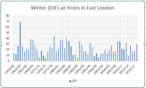
There were 30 air frosts during the three months, eight above the 1981-2010 average.
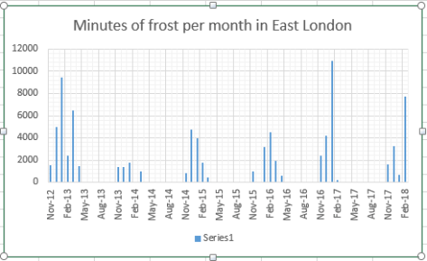
There were 11,680 minutes of frost over the winter, less than last year, though 66 per cent of those were recorded in February. Considering the past 6 Februaries this year’s frost hours were 170 per cent greater than the next highest, February 2016!.
Temperature (°C):
Mean (1 minute) 5.2
Mean (min+max) 5.0
Mean Minimum 2.0
Mean Maximum 8.0
Minimum -6.9 on 27/02/2018
Maximum 14.2 on 30/12/2017
Highest Minimum 10.8 on 28/01/2018
Lowest Maximum -1.0 on 28/02/2018
Air frosts 30
Rainfall (mm):
Total for period 182.2
Wettest day 15.3 on 02/01/2018
High rain rate 28.2 day 02/01/2018
Rain days 52
Dry days 38
Wind (mph):
Highest Gust 45.0 on 02/01/2018
Average Speed 3.7
Wind Run 8059.5 miles
Gale days 0
Pressure (mb):
Maximum 1036.4 on 22/12/2017
Minimum 970.3 on 10/12/2017
Days with snow falling 7
Days with snow lying at 0900 4
Summer 2017 was a season of two halves, the mean temperature of 18.5C (1.3C above average) made it the tenth warmest summer since 1797.
Though it was warm overall it was also wet. Nearly 234mm of rain were collected, 159 per cent of average, making it the wettest summer since 1987.
Just under 535 hours of sun were recorded, 94 per cent of average and the sunniest summer for three years.
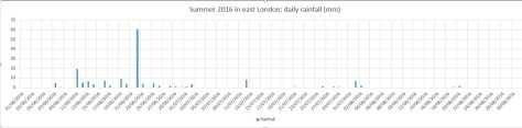
The graph of the mean temperature for the 3 months shows a marked decline from the second week of JulyThere were at least 3 falls of rain greater than 30mm over 24 hours though classic thunderstorms of recent years were notably lackingSunshine was broadly average
Summer 2016 turned out to be a very decent season overall, the mean temperature of 18.7C (1.1C above average) made it the sixth warmest summer since 1797.
While it wasn’t quite up there with the hot summers of 1976 and 2003 it still produced some notable records. The stormy beginning to June effectively ended with the Brexit vote, a period of 24 hours that coincided with the highest daily rainfall this area has seen since at least 1959.
The multi-cell thunderstorm in the early hours of June 23rd produced 60.8mm of rainfall, nearly half of the month’s total which became the third wettest June in a record going back to 1797. The high rainfall was in complete contrast to July and August and helped skew the overall figure: 168.6mm is 114 per cent over average summer rainfall.
With so much rainfall overall sunshine was affected with only 451 hours recorded, just 80 per cent of what can be expected in an average summer.
July produced another record, this time the highest overnight minimum recorded since 1959. The minimum of 21.1C was recorded during the early hours of the 20th – coming hours after the hottest day of the year: 33.5C – the 14th hottest day on record.
The warm and very dry theme continued into the final month of summer with the warmest August for 12 years, the 10th warmest and 12th driest since 1797.
My summer forecast, when the monthly probabilities are considered, was broadly correct though I didn’t estimate correctly just how warm it would be.
The winter of 2015/16 was skewed by a ridiculously mild December which brought the natural calendar forward three months.
A persistent flow of air from the Azores caused the unseasonable warmth in December, skewing the overall temperature for the season
Daffodils and other spring bulbs which normally come out in early March in this part of the UK were in full bloom at the end of December. Spring blossom was also very early with many may trees out in early February.
The mean temperature for the season finished 7.38C, that’s 1.9C above average. It was the third warmest winter in my series going back to 1797, behind 1989 / 90 and 1974 / 75.
Rainfall was almost precisely average: 144.8mm fell, within half a millimetre of what normally falls. Sunshine was just under average: 162.8 hrs is just over 5 hours short of what we’d normally expect during December, January and February.
The warmest day of the winter occurred on December 19th with 16.3C recorded, the second warmest December day in my daily record going back to 1959 – the record fell short by just 0.1C.
Snowfall, like the previous two winters, was very scarce
The coldest night of the winter coincided with the coldest mean temperature on January 19th. A low of -5.7C was the lowest value recorded in Wanstead for three years.
The wettest day of the winter occurred on January 10th when 11.6mm, a very unremarkable amount for winter and in complete contrast to the deluge that affected NW England and NE Scotland. There were 51 rain days (where 0.2mm or less fell) and 37 wet days (where 1mm of rain falls over a 24hr period).
Although sunshine was around average there were 24 sunless days.
Snow, like the previous two winters, was very scarce: just one day of snow falling and lying occurred on January 17th, though you had to be up early to see it.
So, all in all, not bad. The Daily Express and others should take note. This is what they printed last November… I’ll leave it up to the reader which forecast was more useful…
This winter was the second sunniest on record in this region. Sunshine hours totalled 238 hours during December, January and February – that’s 142% of average and second only to 2007/08.
Winter 2014/15 was the second sunniest on record with 238 hours of sunshine
The first lying snow for two years is also a notable observation of winter 2014/15. That it lasted just a few hours emphasises how little snow there was at sea-level for the second winter in succession.
The mean temperature of 5.2C was just 0.3C below the 1981-2010 average. Some 152mm of rain fell – that’s just 7mm over the winter average.
Winter began with the sunniest December on record in my series going back to 1877. Over 90 hours of sunshine was recorded in this area which is 224% of what we can expect to see during an average December.
January saw the first falling snow in nearly two years with the last three days of the month seeing the first flakes of winter – nothing much to write home about by average winter standards.
February produced the first lying snow in nearly two years. The 1cm depth at 9am on 3rd, however, is nothing much to write home about by average winter standards.
The wettest day during the three months was January 12th when 13.1mm fell.
Snow fell on 6 days. Air frosts: 27 Ground frosts: 48
Full stats for winter can be found here: http://1drv.ms/1rSfT7Y
At the end of November I published my annual winter forecast. I said the season would *probably* be colder with a better chance of snow than last winter. If I’m honest I thought we’d see more incidents of snowfall though, with my predicted mean temperature of 4.2C being exceeded by 1C, the air around the UK just wasn’t cold enough for snow at sea level. My predicted rainfall was more impressive – I forecast 156mm and was out by just 4mm!
Obviously when the season is average long-range forecasts like this have a much higher chance of being correct. One could argue that basic climatology has made my forecast look a reasonable one. But I stick to what the stats suggest and try to steer clear of the endless hyperbole published almost daily by certain tabloids.


 With so much rainfall overall sunshine was affected with only 451 hours recorded, just 80 per cent of what can be expected in an average summer.
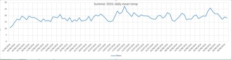


You must be logged in to post a comment.