This September has seen a lot of convective activity with three days of thunder, already more than the whole of meteorological summer.
The first storms arrived during the early hours of the 8th. Lots of thunder and lightning though only 7.1mm of rain. Further storms bubbled up at 1200 and 1720 with 9.8mm of rain.
Both the 11th and 12th have seen further thunderstorms develop with hail recorded though rain amounts were low; with 0.4mm and 0.6mm recorded respectively.
I hadn’t heard of Brettenham before this Suffolk village recorded over 100mm of rain from the convergence line event on the afternoon of Sunday, July 26th.
A former Environment Agency observer recorded 181.3mm in 1hr 40mins (1640-1820).
Notable on its own but even more so given that Wattisham, an official station 7.3km to the south-east, recorded just 2.4mm at the same time.
Whilst intensely isolated events happen, and often go unnoticed if they occur in uninhabited areas, this one seems more severe than what has previously been recorded.
The greatest 24hr rainfall recorded, according to Robin Stirling’s Weather of Britain, was 279mm on July 18th 1955 in Dorset. The rainfall far more widespread than the event on Sunday.
The event in Suffolk was covered by the East Anglian Daily Times. A report that mentions ‘rain falling in sheets and roads turned into rivers’ can be found here.
This May will probably be most remembered for the number of thunderstorms affecting the area. I recorded an unprecedented (in my memory) four consecutive days of thunderstorms.
Convective clouds build over Wanstead Flats
It was also warm with a couple of days making the top 10 of hottest days since 1959. The mean temperature finished 15.1C, 2C warmer than average, the warmest May for seven years and the 8th= warmest since 1797.
Rainfall at 65.5mm was 128 per cent of average and slightly drier than last year.
Some 244hrs of sunshine were recorded, 134 per cent of average, making it the sunniest May for 7 years, and the 11th sunniest since 1881.
Spring finished with a mean temp of 11C, 0.8C above average, 1C cooler than last year. Rainfall at 181.9mm, was 135 per cent of average, making it the wettest spring for 10 years. Sunshine of only 411.2 hours made it the dullest spring since 2006.
Posts about thunderstorms are usually few and far between – the average number of thunderstorms in this part of the UK in a summer month (July) is just 3.5.
So experiencing four in four days must be very rare; the record for thunderstorms in a month is 12 in June 1982 though I’ve no idea how many of these were on consecutive days.
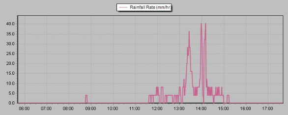
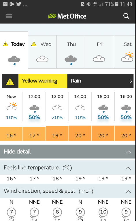
While the storms over the weekend were all about lightning this one was all about rain and loud thunder. Tuesday, May 29th, started cloudy and dull with some light rain. I was expecting some rain but it lingered and became heavier at 11.30am before turning torrential at 1pm, going against forecasts from BBC and Met Office – the trough was a lot further north than modelled. I pointed this out to the UKMO to be told that a yellow warning was in place for the whole SE region.
The bulk of the rain fell between 1pm and 2pm
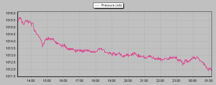
A marked drop in pressure coincided with a bright flash of lightning that was almost instantly followed by thunder that was as loud as cannon fire
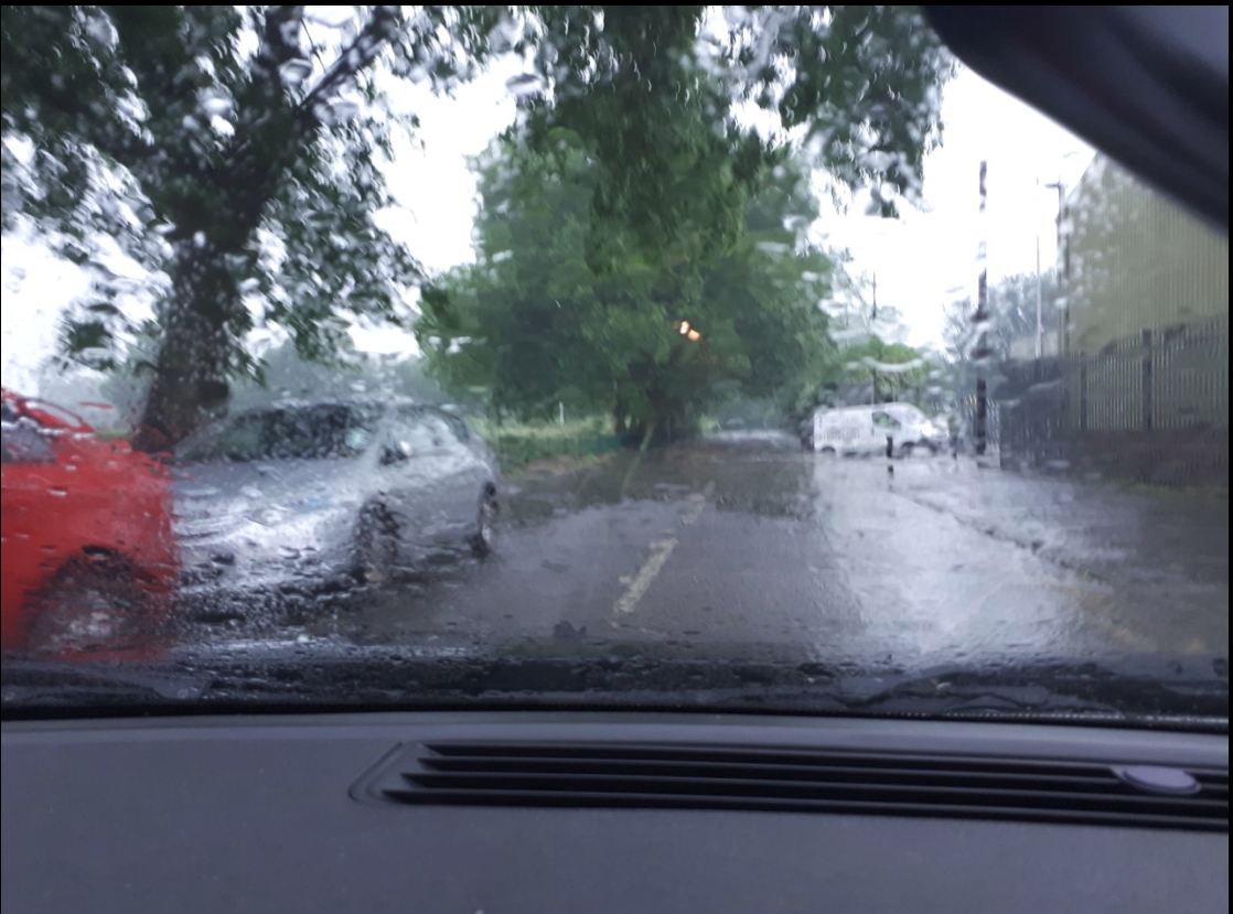
Some 26.5mm fell in just over two hours bringing lots of surface water and flash floods around Leyton and Walthamstow. At 1pm, while driving in this area, a bright flash was quickly followed by cannon-like thunder. A further fall in the early hours brought the 09-09 total rainfall to 29.8mm, the 5th greatest May fall since 1959.
In the neighbouring borough of Barking and Dagenham it was reported that lightning struck a chimney which caused a fire in a terraced house in Rush Green at 2pm.
Local media pick up the story here, here and here.
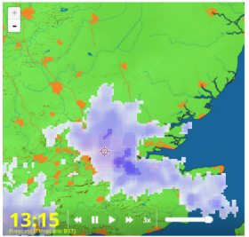
The position of the storm around the time of the loudest thunder
South Access Road in Walthamstow suffered flash flooding as drains failed to cope with the volume of rainfall
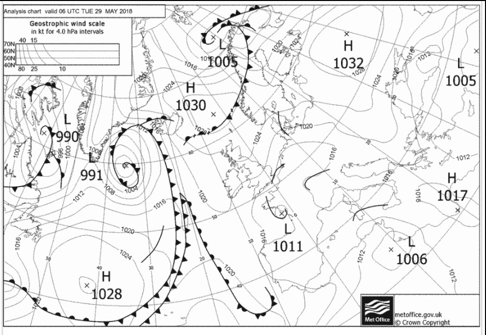
The trough on this FAX chart suggested the heaviest rain would be slightly further south than it was
The Met Office forecast for Tuesday shows how useless auto generated apps can be, the 10-20% risk of rain between 1300-1400 contradicts the yellow warning
Posted by Simon Cardy: “The large mature Cumulonimbus clouds over SE England (outlined purple on the map) are producing frequent lightning, very loud thunder and heavy rain. (credit: EUMETSAT).”
After the previous two days’ thunderstorm events it would be easy for this one to get lost in the ether. However, being super local and how quickly it developed and then died was enough to pique my interest.
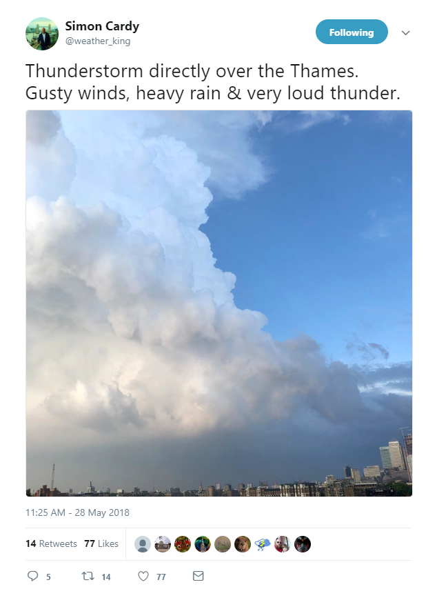
After a very warm and humid afternoon where the temperature peaked at 26.2C clouds began gathering to the east with the first rumbles of thunder at 6.45pm. The huge cumulonimbus could be seen from Southend.
And Simon Cardy took an excellent shot from the other end of the Thames.
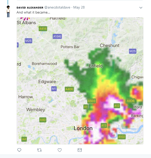
By 8.17pm the storm that had moved west had decayed markedly.
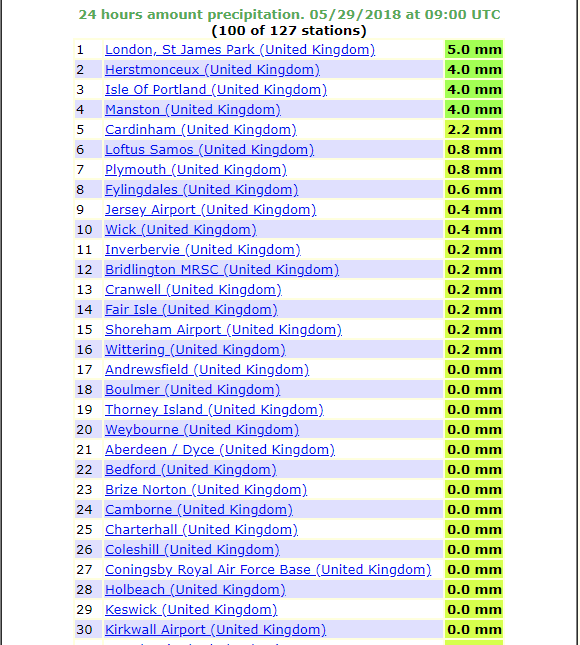
The 24hr rain totals at 09 on May 29th show how local the storm was. St James’s Park, 9 miles to the south-east, recorded half Wanstead’s total.
Timeline (BST)
1840 first peals of thunder heard
1847 first drops of rain
1856 downpour
1857 cloudburst
1901 16mm/hr 1.7mm
1903 very heavy
1909 burst of >5mm hail recorded. Rain rate 60.4mm/hr
1929 rain ceased (10.4mm in total)
Last night’s intense thunderstorm was probably most notable for its high-level sheet lightning than rainfall, thunder or fork lightning.
At my own station I recorded 4.8mm of rain which at its heaviest fell at a rate of 24.1mm/hr at 0046. To put that into perspective that’s just under a quarter of the rainfall rate during the thunderstorm at the beginning of last June. Rainfall in nearby Woodford Wells fell at a rate of 35.6mm/hr at 0040.
The rainfall was much heavier to the west of London.
Also of note was how warm the night was. A low of 15.3C made it the 8th equal warmest May night since 1959.
There’s probably going to be a few more storms this bank holiday weekend though it remains to be seen whether this is going to be a classic summer for storms.
At it’s peak at 2305 there were 16800 strikes, according to Blitzortung.
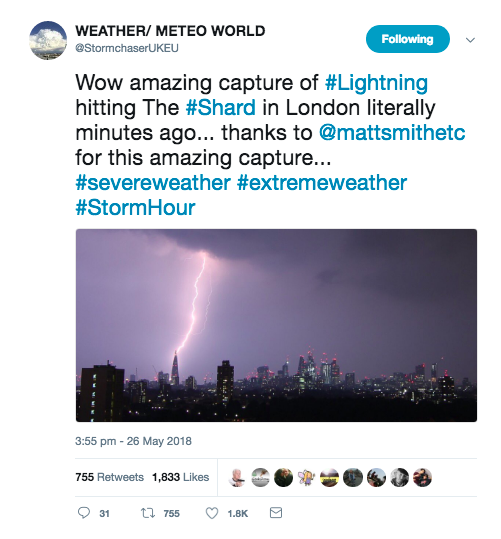
Firefighters were called to a house fire after this house in Essex was struck by lightning overnight. Crews said the entire roof was alight pic.twitter.com/fUSt9jMSgN
The 27th was fairly quiet but with abundant sunshine and little wind it wasn’t long before more storms, this time homegrown, developed over the Midlands and the south. Severe flash flooding was reported in the Selly Oak area of Birmingham after a month’s worth of rain fell.
Reports of severe flash flooding across the city and beyond. This is the scene on Hubert Road in Selly Oak. Please only travel if it’s an emergency as the roads are becoming treacherous. (Video: Alexander Walters) pic.twitter.com/8gA0jjG03R
And as dusk approached a huge storm toward to the north-west of London and Chilterns. With little wind the storm stayed more or less in situ, expending all its energy with the most amazing lightshow – lightning within cloud that became more and more vivid as darkness approached.
Because these storms can reach heights of 29,000ft – roughly the height of Everest – they can be seen from over 40 miles away.
I had a go myself.
Not bad but the best footage I’ve seen was captured by Simon Cardy from east London and can be seen here.
Less than 24 hours after a spectacular lightning display, we have another one! pic.twitter.com/3qnZw9sIb3
The coming bank holiday weekend is looking very warm, possibly hot on Monday. And with the heat comes the inevitable thunderstorms.
Looking at the CAPE forecast on @wxcharts the risk on Saturday looks like staying to the west of London. The best chance for east London looks like after noon on Sunday and Monday. There is no guarantee of thunderstorms here – some places could get hammered while just down the road it could stay dry – the potential is there.
Meteorologists will be keeping a close eye on Herstmonceux and Trappes ascents in the coming days.
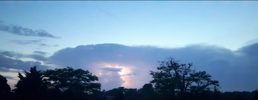
It’s not often you experience what it’s like to be right under a cloudburst but June 2, 2017, provided a perfect example.
Some 31.2mm of rain fell in little over an hour accompanied by frequent thunder and lightning. Some flash flooding was reported and there was an 8C fall in temperature in 2 hours. The max rainfall rate was 108.4mm/hr at 3.49pm.
Elsewhere in London there were reports of ‘golf ball sized’ hail in Orpington. Here is a link to the pictures posted on ukweatherworld.co.uk https://1drv.ms/w/s!Au79-nZSg0ihlSXF5dTb08AQB74b
Tudor Hughes, of Warlingham, NE Surrey, said: “Heavy thunderstorm 1525Z.. Torrential rain and a short spell of large hail near the end. The stones were all spherical with a maximum diameter of 12 mm. Temp fell “vertically” from 22° to 17°. Just measured the rainfall – 12.7 mm, the bulk of which fell in about 7 mins. Rain now (1555 Z) ceased but plenty of Cb still around.”
Smartie, a contributor to the Google group Weather and Climate, explained the science behind the storm.
“The cold front was still to the west, these showers were in a prefrontal trough. South-east London was in the inflow region of the convergence zone and strong initial updraughts and unimpeded ingestion of air from the SE likely accounts for the hail. Storms north and north-east of London likely benefited from urban heat.”
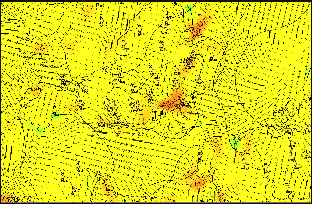
The showers were in a prefrontal trough. Here is the 15 UTC WRF_LAPS objective 10m wind analysis. Red shades are convergence, blue-green divergence. SE London was in the inflow region of the convergence zone and strong initial updraughts and unimpeded ingestion of air from the SE likely accounts for the hail. Storms north and north-east of London likely benefited from urban heat. Chart courtesy of David Smart (UCL)
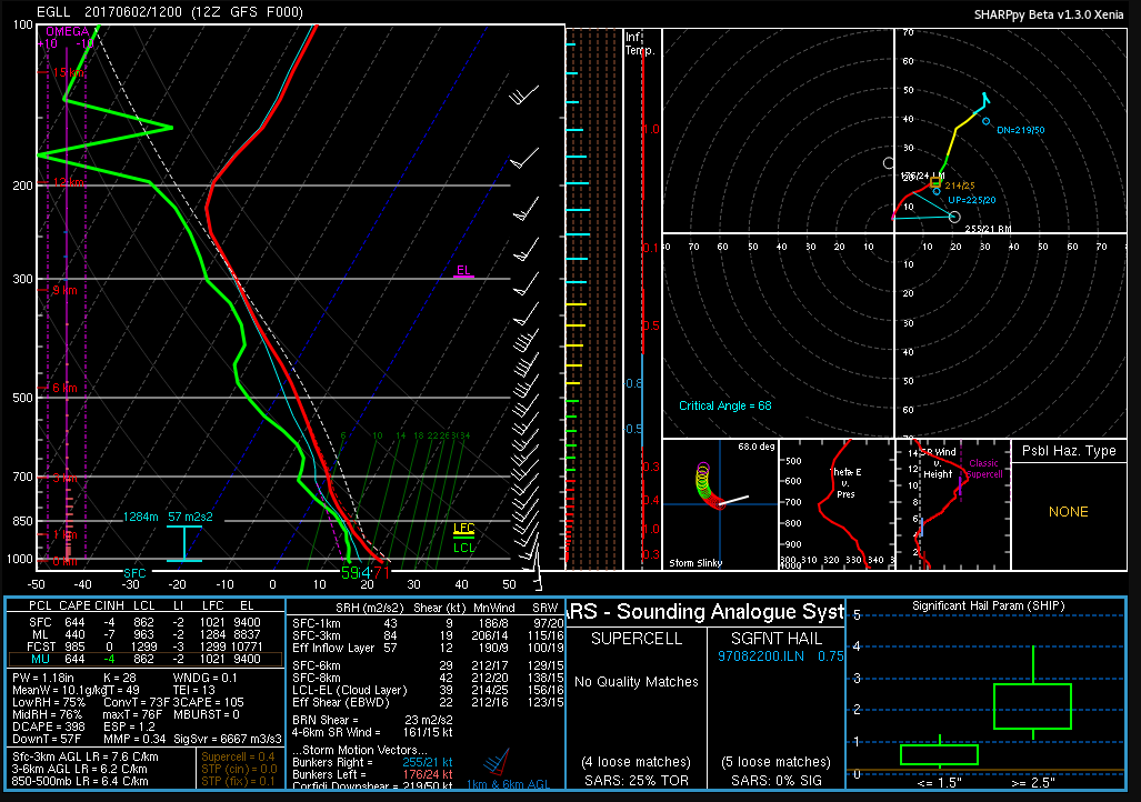
This chart is a SharpPy analysis of the GFS analysis 12 UTC for the Heathrow grid point. Courtesy of Smartie
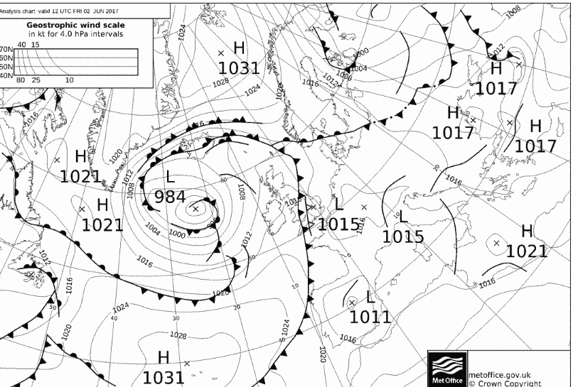
The synoptic chart for 12Z shows the slack flow over London, the perfect set up for slow moving thunderstorms.
It was just before 3am that I was awoken by faint rumblings outside. I knew there was a risk of thunder before I’d retired to bed a few hours earlier but I’d discounted the risk along with any thoughts of staying up to watch the referendum results unfold in Scotland.
This radar shot shows the storm just beginning to hit Wanstead. The rain was far heavier to our east. 17.2mm was reported at Laindon, Essex. An observer at Woodford Wells recorded 19.9mm her in about 25 minutes 0310-0335 bst
Lightning then illuminated the room through the gaps in the curtains followed by more rumblings: it’ll pass, I thought. Crash – I grabbed my phone – was this an isolated event? The radar showed a line of slow moving storms moving up from the south. More lightning and loud thunder. My Twitter feed told me it wasn’t going too well for those wanting independence. At this point intensely bright lightning was rapidly followed by one of the loudest claps of thunder I’ve heard around 3.10am. Car alarms were set off – may as well get up I thought… The Inverclyde result was announced – ‘No’, by the narrowest of margins 50.1% to 49.9%. That’s it then, I thought. The lightning and thunder gradually began to fade away with hopes of an independent Scotland, on this night anyway. I glanced at my stats which seemed far less impressive than what was recorded elsewhere: 7.7mm, no big fall in temperature or pressure like previous storms during the summer.
Just a few hours later I walked my younger daughter into school, my bleary eyes struggling to focus – the humid and steamy atmosphere felt more like July than September. Indeed Thursday had been the warmest September 18th since 1997 which, strangely, was the same year that another momentous British event took place: the handover of Hong Kong to China. I remarked to a couple of parents that the only thing that had changed overnight was that Andy Murray will forever be the “Scottish” tennis player after his comment on Twitter.
The forecast advised that there was a continued threat of thunderstorms. It was humid but it didn’t ‘feel’ stormy – though around 2.30pm I could hear the beginning of faint rumblings in the distance.
Clouds above could be seen developing rapidly at 2.30pm
I left for work on my scooter at 3pm, carefully watching the sky for any developments all of which seemed to be in the distance. After stopping for petrol in Leytonstone High Road huge drops of rain began splattering the pavement. They were few and far between, however, and the sun defiantly continued to shine. After riding past Stratford I suddenly became aware that the buildings in the distance, past Bow flyover, were gradually beginning to disappear. I pulled in to a turning where Gala Bingo is situated. An electronic noticeboard enquired: “Do you feel lucky?” Not today I thought and retrieved my overtrousers that live under the seat, hastily pulling them on as I watched the impending storm begin to close in.
I continued on and was soon enveloped in the full force of another thunderstorm. Marble-sized hail clattered off my crash helmet while dangerous gusts, caused by wind funneling through the new high rise flats by the Olympic Park, did their best to push me off. Just as I crossed the canal a sheet of rain engulfed me and the drivers to my right. The road in front suddenly turned into a shallow river. I usually ride over the flyover – not today with the torrent of water cascading off the sides.
The 3.15pm storm that flooded large parts of East London. The white area shows where the heaviest rain was
By the time I reached Mile End the rain had almost stopped. The City looked fairly dry and on reaching London Bridge the roads were completely dry. The Friday crowds were out in force in Borough Market, enjoying the sunshine and seemingly oblivious to the chaos unfolding just a few miles away in East London. Within 10 minutes of walking into my office Alex Salmond announced his resignation. Another storm: another momentous event! It was another of those coincidental storms that, in my mind, seem to mark momentous events such as the Royal birth last July
I checked the stats of the storm back in Wanstead: 24.5mm fell with a peak rate of 76.5mm/hr at 15.47. The storm ended a run of 16 dry days bringing the total for the month up to 33mm – the 24hr total was 30.5mm. The explosive convection of this storm can be seen here. The associated hail and rain brought much flooding to Hackney, Hackney Wick and Leytonstone. This storm seemed to be the result of a convergence line over London between light southerlies to the south and easterlies to the north – the heavy rain was very localised.
The flooding wasn’t restricted to East London. In Southend water started pouring through the roof of the Dixons theatre though it failed to stop the performance. Shops in London Road were inundated.
I’ve decided to cobble together a few lines on last night’s notable thunderstorms which reminded me so much of the stormy nights on the 1980s.
The radar at 3am, produced by the excellent Home and Dry, revealed that the storm’s rainfall was quite widespread. The white areas show the most intense rainfall
After writing off the risk of storms for our area last night I was awoken at 3am by loud, rumbling thunder – the kind that seems to resonate all around you. A quick look on the radar revealed quite a widespread thunderstorm, quite different from the smaller, more intense one that woke up most of Wanstead on July 23rd last year.
On viewing the live lightning map at 3.10am it became clear that this was no flash in the pan. Further rumbles and strikes had me leaping out of bed to monitor the station. EssexWeather reported 1809 lightning strikes in two hours for our region.
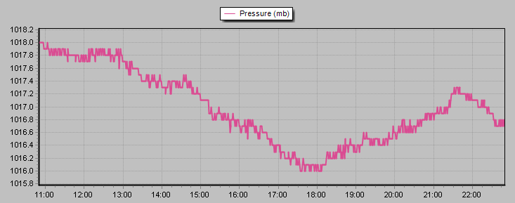
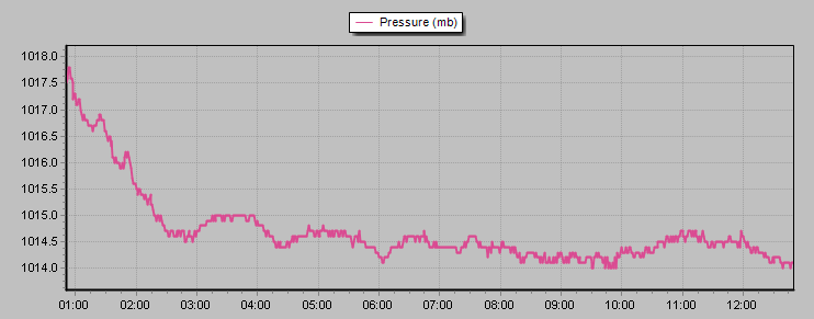
And on viewing the pressure graph the first storm saw a 6mb fall in pressure in a matter of minutes.
A second storm around 5.30am was less severe though still notable. The 9.4mm that the weather station recorded fell at a rate of 45mm/hr at 3am and 40mm/hr at 5.15am. Though the AWS is often out in heavy rainfall situations on this occasion it was more or less spot on – my 10am reading of my traditional 5″ raingauge revealed the official total to be 9.3mm. The rain took the July total to 108% of the 1981-2010 mean.
And a squall that blew through just before 4am is well portrayed on this wind graph.
So, all in all, a really lively sticky night where the temperature didn’t fall below 18.2C. I didn’t manage to get any of my own pictures but this one by @justinstokes on Twitter caught my eye.
According to the CAPE / lifted index further storms seem likely tonight. Indeed the situation across the Channel could be dire. It is probable a few will trundle their way across the sea to give us another sleepless night…
This wind graph shows a gust of 22.8mph at 0336z in my sheltered garden
Radar at 0519 shows another white blob (very heavy rain) about to cross Wanstead
This pressure trace shows the fall in pressure of the two thunderstorms that crossed our region


You must be logged in to post a comment.