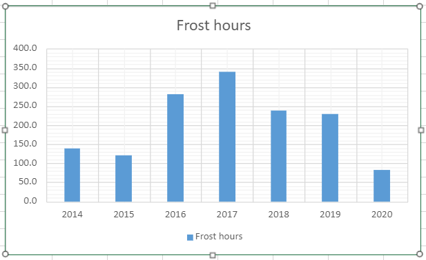
Frost is a rare beast this year, even in the Wanstead Park frost hollow.
So far this year I’ve recorded just 82.5 hours where temperatures at 4ft (1.2m) were -0.1C or below. That’s just 37 per cent of what is recorded in an average year. And would suggest that frosts in December will be above average.
The lack of frost this year is even more remarkable given that the past seven years, especially the winters, have been so mild.
A closer look at the data shows that winter months are no guarantee of seeing temperatures fall below freezing. The record mild December 2015 and February 2014 are testament to that.
The fact that January 2017 looks the most remarkable month for frost reveals just how mild recent years have been.
Although many parts of the UK have already recorded their first air frost this part of the capital, being so built up and close to the City, remains frost free.
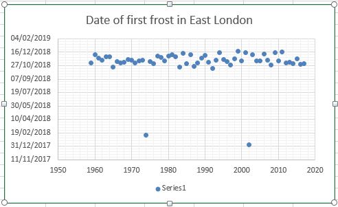
Although many may think that frosts are getting later a look back through local statistics to 1959 shows these events are very random.
The scatter graph below illustrates this.
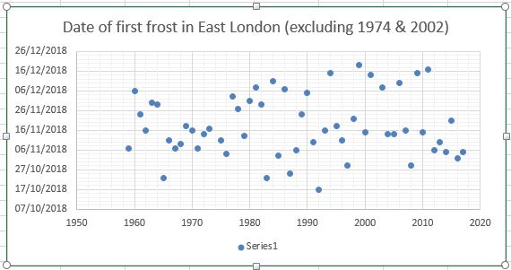
Taking out the winters of 1974/75 and 2002/03, which didn’t see frosts until February and January respectively, the scatter can be seen better here.
The median for the first frost is November 6th with an average minimum of -1.4C.
October frosts can be a precursor to a mild winter much in the same way that heavy October snowfall in the Alps has lead to an awful season. But there are exceptions, as happened in 2008/09.
* To record an air frost the temperature must fall to -0.1C or lower.
There was much talk yesterday about a lot of the south of the England recording an ‘ice day’.
In the London area most places missed out because the temperature rose briefly above freezing around dusk and also just before the 0900 observation today.
So although it felt brass monkeys out there it doesn’t count.
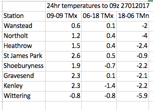
Ice days are when the temperature fails to rise above -0.1C over a 24 hour period, usually from 0900 to 0900. The confusion over yesterday’s ice day was caused by the fact that some stations release a 06-18 maximum reading – both Kenley and Shoebury stayed below zero in this time period.
Ice days in the Wanstead area are probably even rarer than decent snowfalls. Since 1959 there have been 81 ice days.
The last time the temperature failed to rise above 0.0C was January 20th 2013. The last time the temperature failed to rise above -0.1C (a true ice day) was January 6th 2010.
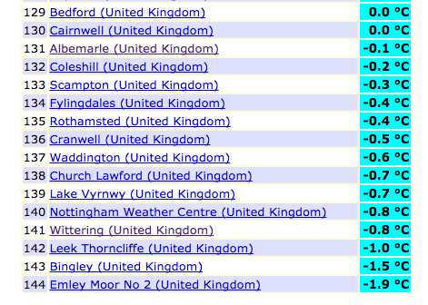
Over a dozen stations stayed below freezing for 24hrs to 09z on January 27th
Stephen Davenport’s synoptic analysis of the event is included below:
“[The cold conditions were] all thanks to this nicely (or not nicely, depending on your view) blocked situation. On Tuesday 24th a 500 hPa ridge started build northeastwards to the north of a small upper low situated over France. By 12z on Wednesday 25th it had cut off to leave a classic-looking Rex block over western Europe:
Surface winds from the Continent started to bring colder air across as the temperature anomaly analysis for 12z Wed 25th shows, while milder southerlies continued across Ireland and Scotland, and brushed western Wales and SW England:
By 12z Thursday 26th the block was becoming more omega-like…
… and cold air continued to percolate north-westwards from the Continent farther across the British Isles:
There’s a certain beauty in the sinusoidal flow around a Rex block, I always think.”
Rain, rain and more rain. Winter 2013/14 will be most remembered for its incessant precipitation that brought flooding to many parts of the country including the Somerset Levels and many towns and villages along the Thames. But, in this locality, it was no record breaker – being only the 6th wettest in my series going back to 1797. The mean temperature of 6.7C made it the 10th mildest, a full degree colder than the warmest winter of 1989/90.
The water table appears to have come to the surface on Wanstead Flats
The winter was notable for its complete lack of lying and falling snow. Indeed NO snow falling was observed for the entire three months – something that hasn’t happened in this area in at least 50 years – possibly longer. There’s still a chance of snowfall before April’s out – the snowfall season can last from November to May – but with the increasing strength of the sun any snow cover will be short-lived.
The opening few days of December were calm and quiet but a storm on 5th caused two deaths and much damage in the north; a tidal surge in the North Sea brought flooding along the east coast. The coldest spell of the winter arrived the second week of December with fog and a couple of frosts. From the 15th, however, the Atlantic cranked into life and pretty much drove the weather for the whole winter. A strong jetstream stayed over or very close to the UK for much of the three months, driving depression after depression over the British Isles.
Though daily totals were not record-breaking it was noticeable how much heavier the rain was at times across the Thames. A storm that ran from December 23rd into Christmas Eve brought 23.4mm of rain to Wanstead while at Kenley, 17.5 miles away, over four times as much was recorded. The intense streamer of rain and high winds brought power cuts to Gatwick airport, delaying thousands of travellers on their way home for Christmas. Five people were killed as a result of the storm.
Damaging gusts associated with the depression on December 23rd felled this tree by the war memorial in Wanstead High Street
The wet theme continued through January with added thunder and lightning. The most notable day was Saturday 25th when what started as a bright, fine day quickly changed around 4pm as a strong squall with heavy rain blew through with associated thunder and lightning and 6C fall in temperature in an hour. Wanstead escaped the damage of elsewhere. Numerous trees blocked rail lines in Kent and gusts of over 60mph were widely reported.
There were two other incidents of thunder and lightning on 5th and 6th – very unusual in the middle of winter and an average normally observed in high summer.
Yet more rain greeted the month of February though things turned somewhat dryer after 15th, though rainfall for this month was still over 180% of normal. A storm on the evening of Valentine’s Day into 15th saw yet more damage, resulting in two deaths including a man killed by a wave on a cruise ship in the Channel. A woman was killed when a 3ft by 3ft block of falling masonry crushed her car outside Holborn station.
For anyone who likes cold weather it has been a dreadful winter so far with no snow falling or lying in this part of Britain.
An inversion during the first half of December saw the edges of ponds in Wanstead Park begin to ice up
A very mobile synoptic regime has seen numerous vigorous depressions blowing in off the Atlantic bringing flooding misery for many as swollen rivers burst their banks.
The predominantly maritime air over us has meant that even air frosts have been few and far between.
Since December 1st, Wanstead has recorded just 7 air frosts – half the number of last year. The coldest night was just -2.9C , warmer than the -6.9C recorded by this point last January.
The current mean temperature this winter to January 14th is 6.6C with rainfall 133mm – statistics that are remarkably similar to the winter of 1985/86 (mean 6.8C rainfall 130mm). That December and January was followed by a very cold February – the 4th coldest in a series stretching back to 1881.
However, before any coldies reading this get excited it should be noted that this season is also remarkably similar to winter 1989/90 (mean 6.8C, rainfall 128mm), which was followed by more stormy weather, including the Burns’ Day Storm, and the warmest February on record in this region.
Further scrutiny of stats for the Wanstead area reveal other years were similar. Using my method for finding patterns stretching back over 50 years to forecast this winter I picked out years that were +/- 10% of the mean. From these I then weeded out the seasons where the rain was +/- 10% of the 2013/14 rainfall total. This gave a list of five other winters with similar temperature and rainfall. Leaving aside 1985/86 and 1989/90 the other winters weren’t anything special with ‘snow lying’ days below the median for this area of six.
As I write this there are tentative signs on the weather models that a Scandinavian high may begin to form next week, introducing colder air from the east – exactly what we need to precipitate snow. However, they are just tentative signs and the cold air may never reach this far west anyway. Bear in mind also just how strong the influence from the Atlantic has been so far this winter. The Met Office have said the storms have been the worst in 20 years – which takes us back to the year in the above table of 1993/94. The only snow lying in that DJF season occurred in a short cold snap around February 15th – though, admittedly, an impressive fall of snow happened the previous November.
So, in summary, the probability at this point of at least one fall of snow before the end of February could be put at 75%. No snow: 25%. Abundant snow: 25%.
Damaging gusts associated with the depression on December 23rd felled this tree by the war memorial in Wanstead High Street
While compiling the figures I found that for my winter forecast to be correct would need a second half to winter exactly the same as 1985/86.
Some comparisons have been made between this winter and the balmy winter of 1988/89 – though that winter, the second warmest in the 1960-2014 series up to this halfway point, was a full degree warmer than this season and much drier, with only 30.9mm falling in over 6 weeks.
The culprit of the dry weather of that season 24 years ago was the influence of a very strong European high pressure which ‘blocked’ weather fronts from reaching this part of the UK, sending a conveyor belt of depressions skirting over Scotland bringing incessant rain instead of snow to Cairngorm resorts.
The nature of the weather this time round has been very different. Though December started with a strong anticyclone over Europe fronts associated with very deep depressions off the Atlantic have made inroads deep into the continent.
A classic Genoa low brought over 2 metres of snow above about 1,000m on Christmas day to resorts on the south side of the Alps. The nature of the airflow subsequent to that, however has brought some very high temperatures for the year.
Scottish and continental European winter sports enthusiasts will remember the season of 1988/89 well for all the wrong reasons, with little snow falling before March. I can vividly remember some amazingly cheap skiing holidays advertised on Teletext in January 1990. One deal was a week to Andorra for £19, including flights, transfers and half board in a 3-star hotel. A few of the lads in my A-level economics class took full advantage – only to return with tales about snowless mountains, sprained knees and wrecked skis, though it’s not clear how much of an influence the duty-free booze had.
Although many resorts were already investing in artificial snowmaking it was this season that quickened the pace of investment in snow cannons.
Much has been printed in the tabloids over the past month or so that we are in for a severe winter. Not a week goes by without the Daily Express splashing that the ‘Worst winter EVER is on the way’. Just this morning the same rag told us that three months of ‘exceptionally cold’ weather are due. On closer inspection the story elaborated the scene with quotes from James Madden of Exacta Weather, one of the ‘experts’ feeding these fantastical stories.
The Temple, Wanstead Park, always looks that much more stunning with a covering of snow
Quite how Mr Madden and other experts arrive at these forecasts is a bit of a mystery. The mystery has deepened further since I decided to crunch a few numbers and try to predict what is in store for the months ahead. Looking at data for this area stretching back over 130 years to 1881 I decided to calculate a seasonal average and arrived at a final figure using singularities – basically looking at the weather patterns we’ve had during October and November.
Many professionals would scoff at this method of pattern-matching, so I’ve incorporated a couple of other ‘now’ factors and taken on board current variables such as sea surface temperatures in the Atlantic and Pacific.
The figure I arrived at, taken as an average of the closest matching autumn periods, is a mean temperature of 4C with rainfall totalling 133mm over the months of December, January and February – that’s about a degree colder than average and 90% of average rainfall. The probability of a winter with a mean temperature of between 4C and 5C is 37% – the most likely outcome. With this in mind a winter in the form of 1986-87 is possible – though whether we would see the same extremes of temperature and snowfall that we experienced in January 1987 is open to question.
The Met Office, with all their computing power and expertise, seem to be hinting at something similar – ie slightly colder than normal. The opening couple of weeks to my forecast seem quite plausible, looking at tonight’s models. Look at the similarity in the synoptic charts for December 8th here.
Shoulder of Mutton pond, Wanstead Park
Over the last few years the snow lovers among us have been spoiled after a run of very mild winters during the late Nineties and early Noughties that prompted climate expert Dr David Viner to utter the immortal words that one day “children just aren’t going to know what snow is”. It was only a matter of a few years before the words from the senior research scientist at the University of East Anglia seemed a bit hollow.
Mark Twain, born this day in 1835 , once uttered the famous phrase: “Climate is what we expect; weather is what we get” – there is always a chance we could suddenly lurch back to milder winters. This winter could spring a surprise, be it very cold or very mild. But judging what’s happened over the last 130-odd years – a 1962/63 or a balmy 1989/90 look very unlikely.
* Forecasting models use probability on any given outcome. Millions of observations are fed into the Met Office database (and other countries’ weather agencies) every day. Supercomputers then crunch through this data to give probable outcomes. With the volatility of the atmosphere it is not surprising that certainty of any outcome often falls away rapidly. Forecasting has improved greatly in the last 20 years – though anything the models churn out beyond three to five days should be handled with caution. Long range models can give *some* idea of general trends for the months ahead – but changing just one variable can vastly alter an outcome at the end of the run.
* *Over the past few months I have been collating data for the area around Wanstead. This data is freely available from the excellent Met Office library and is emailed via Excel spreadsheet. Rainfall stats include a near-complete daily archive, stretching from 1961 to 2003, from City of London Cemetery . Sadly the rainfall station, along with many others, ceased to supply the Met Office after cuts were made shortly after the turn of century. Prior to 1961 I have used monthly figures taken at the Greenwich Royal Observatory stretching back to 1881. Though this is 6 miles away the difference in temperature between the two areas would be miniscule compared with rainfall data and so can be used. I use my own stats for the period after 2003.
It’s usually around this time of year that this area experiences its first air frosts – but a warm, wet October caused by an active Atlantic and a jet stream sitting close to us has meant that classic radiative cooling nights have been in very short supply. There’s been a couple of chilly nights – down to 2.6C on October 30th and November 5th – but to record an air frost the thermometer must read below 0 Celsius (32Fahrenheit).
The first frost last year was recorded on November 6th. Much hoar was seen around the shady banks of Shoulder of Mutton pond in Wanstead Park
Last year, Wanstead recorded its first air frost on November 6th (-1C). Looking back through the records to 1980 the earliest frost was October 17, 1992, and the latest was January 6th, 2004. Interestingly it appears that having frost in October can signal a mild winter to come!. The median for the first frost is November 16th – 18th. Forecasts for this week suggest we could be scraping the windscreens for the first time on Saturday, thanks to high pressure building in from the Atlantic and calming things down.
Indeed, the models today suggest there is a chance of a block forming in the Atlantic which effectively stops depressions from whistling in from the west, unlocking the door for cooler weather from the north or east. It’s a long way off in meteorological terms though.
Here is a list of first air frosts in Wanstead…
The ECMWF model shows high pressure ridging in from the Azores at the end of the week
Is Guy Fawkes’ Night going to turn into a damp squib this year? The forecasts don’t look good – our best hope is for a brief ridge to briefly quieten things down before the next frontal system trundles in from the Atlantic.
What was a very wet week last year led to the cancellation of the public display on Wanstead Flats – with 10.2mm of rain on the Saturday flooding the already sodden land. The forecast for this year doesn’t look much better with 16mm of rain due between Friday and dusk on Sunday.
The cloud cover / rainfall chart for 6pm Tuesday shows that the front may have cleared through by the time the bonfires are lit. At this range, though, it is a big if
But what about the actual 5th of November? Monday looks very wet for this region with yet another frontal system sweeping across the south. Up to an inch of rain could fall before dusk on Tuesday driven along by a stiff westerly wind. The only positive, if you can call it that, is it will be very mild. Temperatures will only fall to around 14C which is very warm for a night in early November.
It wasn’t always like this – ask most people of a certain age what the weather was like on Bonfire Night in their youth and most will answer ‘calm, cold and frosty’ – the bonfire providing a source of warmth as well as somewhere to roast the chestnuts and toast the marshmallows. But were frosty nights on Guy Fawkes in the 1980s that common? I decided to have a look back through the archives and find out.
The FAX for November 5 shows an occluded front right over our region at 12noon. This may have cleared through by 6pm
Only 4 nights in the Eighties could really be described as approaching frosty – they were 1980, 1981, 1989 and 1988 which was the coldest Guy Fawkes’ of the past 30 odd years with the temperature falling to 0.4C. All the other years had minimums of between 5-10C. One thing that is noticeable is how dry November 5 was in the 1980s – just 2 years had any measurable amounts of rain; 1986 (0.5mm) and 1984 (3mm). Nineties Bonfire Nights were even warmer – nearly 1.5C warmer on average – the coldest years being 1991 and 1998 with 2C.
Noughties Bonfire Nights were a continuation on the Nineties – mild though over half were dry affairs. The overall average over the last 30 years is quite surprising – 12C during the day and only falling to just over 6C at night. Taking the average of the last five years the minimum rises to nearly 8.5C! The odds of it raining heavily on Bonfire Night, meanwhile, average out about 1 in 5. Raining lightly the odds increase to a 40% chance.
And as for that wished-for frosty night? Forget it. It seems memories of perfectly frosty Bonfire Nights are about as elusive as the Dickens-style winter snow images that are still so common on Christmas cards.
The next seven days look to be remaining cold, with a risk of snow at times. The temperature will struggle to get above freezing most days – maximums are likely to average 0.1c by the end of the week. Minimums are forecast to average -4.6C – so plenty of frost around again and some very low minima possible should any snow settle. Despite warnings to the contrary by the Met Office I am not expecting Friday / Saturday’s snow event to amount to much for our area – 5cm to 8cm at most – with all of the action well to the west of us and over high ground. There’s a chance that the front will fragment before reaching us – or even stalling over southern England before “pivoting” away into France. This scenario has happened many times before when we’ve had a “block” of very cold air to our east and north-east as we do now. Another event looks possible on Tuesday – but don’t be surprised if we see very little snow.
The past week, as discussed in the last bulletin, saw a change to progressively colder weather, the change being very marked last Wednesday with the appearance of the sun after days of cloud and gloom. The murk and cloud returned though it stayed cold, by Saturday with a chill east wind. Sunday failed to bring the predicted snow – the front just wasn’t powerful enough against the cold block to our east. However, Monday was different and snow began to fall around 5am on Monday, giving a 1cm covering. The track of the low saw a warm sector pass over up, raising the dew point and turning the snow to rain at low levels. Epping and areas of a similar height managed to remain snowy.
Mean temp: 1.2C; Mean min -0.8C (0.2c warmer than forecast), Mean max 3.1C (1.1c warmer than forecast),
lowest min -3.5C(15th), highest max 4.7C (3rd), total rain 3.9mm


You must be logged in to post a comment.