The coming winter is likely to be mild and wet thanks to a predominant south-westerly Atlantic regime.
This year I have tried to improve my statistical method by using historic data from across the capital thanks to the Met Office’s ever expanding library of data; daily Kew values now date back to 1881!
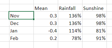
In terms of rainfall and mean temperature a total of eight years were similar to this October and November, spanning 1929 to 2020.
The probabilities for the following DJF winter were thus.
Mean temperature
Probability
Rainfall
Probability
Very mild
37%
Wet
37%
Average to mild
51%
Average
63%
Below average
12%
Dry
0%
London winter forecast 2023/24
Looking deeper into the stats I had a look at the Oceanic Niño Index; the most similar years to this one were 1982 and 1987.
A note on WeatherWeb mentions exception rainfall in the Lewes & Brighton area of Sussex, between 20th September and 31st December 1982.
January 1988 was the wettest in England and Wales for over 40 years, and the wettest at Hampstead since records began there in 1909.
February of that winter also saw a major storm affecting much of the British Isles on the 10th and 11th with much damage to buildings.
The prognosis for snow at this point seems bleak – though chances may be heightened should we experience a stratospheric sudden warming in December / January. Though, as seen in 1987 where a vortex ‘split’ was recorded, this would still not guarantee wintry weather.
Taking the above years into account would give a winter where the average mean would follow this graph. Therefore, after the cold snap during the first week of December, the temperature gradually climbs through the month until the 18th when the will be a gradual drop for a possible cold snap between Christmas and New Year.
This then followed by the usual warm up in the new year with changeable weather through January. The best chance of a sustained cold snap appears to be from February 7th to 13th.
Lots of hype regarding winter at the moment with contradictory model output being released almost daily.
My early take on this is based on the current state of the El Nino Southern Oscillation (ENSO) index which is currently -0.6 and trending more negative (La Nina).
Using analogues from previous events would suggest that the coming winter in the south-east of England will be broadly average in terms of mean temperature and wetter than average.
Looking more closely at each year suggests the following.
Further scrutiny of the local statistics suggest that the mean temperature for November could be lower than average, some 1.7C below average with rainfall around 20 per cent below average.
I should be noted, however, that in the years that were most similar to this September and October (1958, 1961, 1967, 2001, 2005, 2019) the ENSO index was much closer to neutral than it is now. In other words what happens next month could be vastly different to what happened in those years.
Years prior to those mentioned above add intrigue as ENSO statistics are not available.
1802 (cold January 1803), 1849 (severe January 1850 with ice in the Thames) 1862, 1865 (heavy snow southern England 10/11 January) 1874 (notable December storm)
Obviously a lot can change atmospherically in the next few weeks; this is an early take on my usual winter forecast which will be released on December 1st.
When it comes to explaining weather phenomena the British media has often been found wanting over recent years. But when the Australian Bureau of Meteorology yesterday confirmed the emergence of a fresh El Niño newspapers and TV stations inevitably reached the conclusion that the phenomena will trigger a severe winter in the UK.
Sky News told us that it “could also result in a harsh winter for the UK; during the last El Nino in 2009/10, Britain suffered heavy snowfall”, before showing us newsreels of what looked like conditions in December 2010 – the winter after.
I decided to have a look at the facts to see what the effect of an El Nino episode was by comparing the US weather agency NOAA’s data on ENSO episodes going back to 1950 with my own data. For speed I used my top ten snowy winters and compared against the NOAA data. The results showed that eight cold winters followed an ENSO pattern that was negative. The winter of 2009-10 seems to be the exception to the rule. Indeed, a significant El Niño episode in 1997/98, preceded the third warmest winter in my series going back to 1797!
El Niño / ENSO is just one variable when it comes to forecasting a season ahead. Other variables to consider are AO, QBO, MJO and this is before SSWs, sudden volcanic eruptions and sunspot activity throw spanners in the works.
It is exasperating that both the Sky and Telegraph stories were copiously shared on social media – prompting the inevitable comments along the lines of: “They’re talking rubbish, they can’t forecast what that weather will be tomorrow!”
But rather than badly informed journalists it is the Met Office and other noble agencies who will share the blame if the story is incorrect.
There is no doubt that El Niño will disrupt the weather around the Pacific rim but, considering the data we have available, I don’t think it, alone, will be the reason Britain may experience a severe winter this year.
** NOAA’s monthly diagnostic discussion just released (14/5) says:
“There is an approximately 90% chance that El Niño will continue through Northern Hemisphere summer 2015, and a greater than 80% chance it will last through 2015.”
Much has been printed in the tabloids over the past month or so that we are in for a severe winter. Not a week goes by without the Daily Express splashing that the ‘Worst winter EVER is on the way’. Just this morning the same rag told us that three months of ‘exceptionally cold’ weather are due. On closer inspection the story elaborated the scene with quotes from James Madden of Exacta Weather, one of the ‘experts’ feeding these fantastical stories.
The Temple, Wanstead Park, always looks that much more stunning with a covering of snow
Quite how Mr Madden and other experts arrive at these forecasts is a bit of a mystery. The mystery has deepened further since I decided to crunch a few numbers and try to predict what is in store for the months ahead. Looking at data for this area stretching back over 130 years to 1881 I decided to calculate a seasonal average and arrived at a final figure using singularities – basically looking at the weather patterns we’ve had during October and November.
Many professionals would scoff at this method of pattern-matching, so I’ve incorporated a couple of other ‘now’ factors and taken on board current variables such as sea surface temperatures in the Atlantic and Pacific.
The figure I arrived at, taken as an average of the closest matching autumn periods, is a mean temperature of 4C with rainfall totalling 133mm over the months of December, January and February – that’s about a degree colder than average and 90% of average rainfall. The probability of a winter with a mean temperature of between 4C and 5C is 37% – the most likely outcome. With this in mind a winter in the form of 1986-87 is possible – though whether we would see the same extremes of temperature and snowfall that we experienced in January 1987 is open to question.
The Met Office, with all their computing power and expertise, seem to be hinting at something similar – ie slightly colder than normal. The opening couple of weeks to my forecast seem quite plausible, looking at tonight’s models. Look at the similarity in the synoptic charts for December 8th here.
Shoulder of Mutton pond, Wanstead Park
Over the last few years the snow lovers among us have been spoiled after a run of very mild winters during the late Nineties and early Noughties that prompted climate expert Dr David Viner to utter the immortal words that one day “children just aren’t going to know what snow is”. It was only a matter of a few years before the words from the senior research scientist at the University of East Anglia seemed a bit hollow.
Mark Twain, born this day in 1835 , once uttered the famous phrase: “Climate is what we expect; weather is what we get” – there is always a chance we could suddenly lurch back to milder winters. This winter could spring a surprise, be it very cold or very mild. But judging what’s happened over the last 130-odd years – a 1962/63 or a balmy 1989/90 look very unlikely.
* Forecasting models use probability on any given outcome. Millions of observations are fed into the Met Office database (and other countries’ weather agencies) every day. Supercomputers then crunch through this data to give probable outcomes. With the volatility of the atmosphere it is not surprising that certainty of any outcome often falls away rapidly. Forecasting has improved greatly in the last 20 years – though anything the models churn out beyond three to five days should be handled with caution. Long range models can give *some* idea of general trends for the months ahead – but changing just one variable can vastly alter an outcome at the end of the run.
* *Over the past few months I have been collating data for the area around Wanstead. This data is freely available from the excellent Met Office library and is emailed via Excel spreadsheet. Rainfall stats include a near-complete daily archive, stretching from 1961 to 2003, from City of London Cemetery . Sadly the rainfall station, along with many others, ceased to supply the Met Office after cuts were made shortly after the turn of century. Prior to 1961 I have used monthly figures taken at the Greenwich Royal Observatory stretching back to 1881. Though this is 6 miles away the difference in temperature between the two areas would be miniscule compared with rainfall data and so can be used. I use my own stats for the period after 2003.


You must be logged in to post a comment.