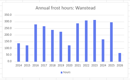
The opening week or so of 2026 has already seen 30 per cent of frost hours recorded locally in an average year.
The temperature at the site in Wanstead has been -0.1C or lower for nearly 64 hours, already more than half of what was recorded here in the whole of 2020.
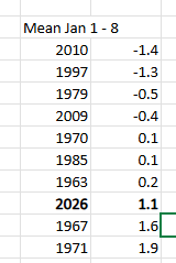
The mean for January is currently 1.1C, 4.1C below average. It’s also been a wet start with 28mm of rain, 53 per cent of the whole month average.
While there’s been colder starts to a year continuous data that allows this kind of analysis only stretches back to 2014 on this site.
Frost is a rare beast this year, even in the Wanstead Park frost hollow.
So far this year I’ve recorded just 82.5 hours where temperatures at 4ft (1.2m) were -0.1C or below. That’s just 37 per cent of what is recorded in an average year. And would suggest that frosts in December will be above average.
The lack of frost this year is even more remarkable given that the past seven years, especially the winters, have been so mild.
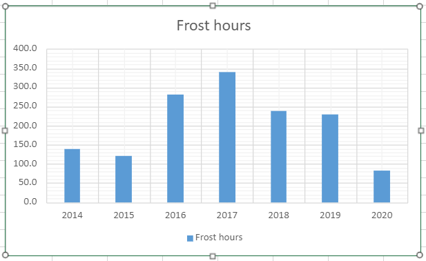
A closer look at the data shows that winter months are no guarantee of seeing temperatures fall below freezing. The record mild December 2015 and February 2014 are testament to that.
The fact that January 2017 looks the most remarkable month for frost reveals just how mild recent years have been.
There was much talk yesterday about a lot of the south of the England recording an ‘ice day’.
In the London area most places missed out because the temperature rose briefly above freezing around dusk and also just before the 0900 observation today.
So although it felt brass monkeys out there it doesn’t count.
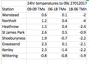
Ice days are when the temperature fails to rise above -0.1C over a 24 hour period, usually from 0900 to 0900. The confusion over yesterday’s ice day was caused by the fact that some stations release a 06-18 maximum reading – both Kenley and Shoebury stayed below zero in this time period.
Ice days in the Wanstead area are probably even rarer than decent snowfalls. Since 1959 there have been 81 ice days.
The last time the temperature failed to rise above 0.0C was January 20th 2013. The last time the temperature failed to rise above -0.1C (a true ice day) was January 6th 2010.
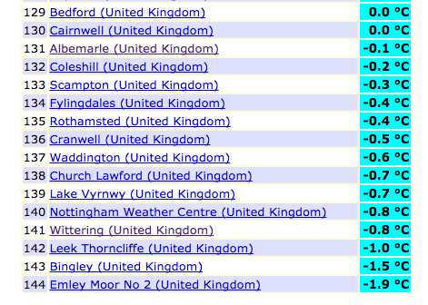
Over a dozen stations stayed below freezing for 24hrs to 09z on January 27th
Stephen Davenport’s synoptic analysis of the event is included below:
“[The cold conditions were] all thanks to this nicely (or not nicely, depending on your view) blocked situation. On Tuesday 24th a 500 hPa ridge started build northeastwards to the north of a small upper low situated over France. By 12z on Wednesday 25th it had cut off to leave a classic-looking Rex block over western Europe:
Surface winds from the Continent started to bring colder air across as the temperature anomaly analysis for 12z Wed 25th shows, while milder southerlies continued across Ireland and Scotland, and brushed western Wales and SW England:
By 12z Thursday 26th the block was becoming more omega-like…
… and cold air continued to percolate north-westwards from the Continent farther across the British Isles:
There’s a certain beauty in the sinusoidal flow around a Rex block, I always think.”
This winter was the second sunniest on record in this region. Sunshine hours totalled 238 hours during December, January and February – that’s 142% of average and second only to 2007/08.
Winter 2014/15 was the second sunniest on record with 238 hours of sunshine
The first lying snow for two years is also a notable observation of winter 2014/15. That it lasted just a few hours emphasises how little snow there was at sea-level for the second winter in succession.
The mean temperature of 5.2C was just 0.3C below the 1981-2010 average. Some 152mm of rain fell – that’s just 7mm over the winter average.
Winter began with the sunniest December on record in my series going back to 1877. Over 90 hours of sunshine was recorded in this area which is 224% of what we can expect to see during an average December.
January saw the first falling snow in nearly two years with the last three days of the month seeing the first flakes of winter – nothing much to write home about by average winter standards.
February produced the first lying snow in nearly two years. The 1cm depth at 9am on 3rd, however, is nothing much to write home about by average winter standards.
The wettest day during the three months was January 12th when 13.1mm fell.
Snow fell on 6 days. Air frosts: 27 Ground frosts: 48
Full stats for winter can be found here: http://1drv.ms/1rSfT7Y
At the end of November I published my annual winter forecast. I said the season would *probably* be colder with a better chance of snow than last winter. If I’m honest I thought we’d see more incidents of snowfall though, with my predicted mean temperature of 4.2C being exceeded by 1C, the air around the UK just wasn’t cold enough for snow at sea level. My predicted rainfall was more impressive – I forecast 156mm and was out by just 4mm!
Obviously when the season is average long-range forecasts like this have a much higher chance of being correct. One could argue that basic climatology has made my forecast look a reasonable one. But I stick to what the stats suggest and try to steer clear of the endless hyperbole published almost daily by certain tabloids.
Rain, rain and more rain. Winter 2013/14 will be most remembered for its incessant precipitation that brought flooding to many parts of the country including the Somerset Levels and many towns and villages along the Thames. But, in this locality, it was no record breaker – being only the 6th wettest in my series going back to 1797. The mean temperature of 6.7C made it the 10th mildest, a full degree colder than the warmest winter of 1989/90.
The water table appears to have come to the surface on Wanstead Flats
The winter was notable for its complete lack of lying and falling snow. Indeed NO snow falling was observed for the entire three months – something that hasn’t happened in this area in at least 50 years – possibly longer. There’s still a chance of snowfall before April’s out – the snowfall season can last from November to May – but with the increasing strength of the sun any snow cover will be short-lived.
The opening few days of December were calm and quiet but a storm on 5th caused two deaths and much damage in the north; a tidal surge in the North Sea brought flooding along the east coast. The coldest spell of the winter arrived the second week of December with fog and a couple of frosts. From the 15th, however, the Atlantic cranked into life and pretty much drove the weather for the whole winter. A strong jetstream stayed over or very close to the UK for much of the three months, driving depression after depression over the British Isles.
Though daily totals were not record-breaking it was noticeable how much heavier the rain was at times across the Thames. A storm that ran from December 23rd into Christmas Eve brought 23.4mm of rain to Wanstead while at Kenley, 17.5 miles away, over four times as much was recorded. The intense streamer of rain and high winds brought power cuts to Gatwick airport, delaying thousands of travellers on their way home for Christmas. Five people were killed as a result of the storm.
Damaging gusts associated with the depression on December 23rd felled this tree by the war memorial in Wanstead High Street
The wet theme continued through January with added thunder and lightning. The most notable day was Saturday 25th when what started as a bright, fine day quickly changed around 4pm as a strong squall with heavy rain blew through with associated thunder and lightning and 6C fall in temperature in an hour. Wanstead escaped the damage of elsewhere. Numerous trees blocked rail lines in Kent and gusts of over 60mph were widely reported.
There were two other incidents of thunder and lightning on 5th and 6th – very unusual in the middle of winter and an average normally observed in high summer.
Yet more rain greeted the month of February though things turned somewhat dryer after 15th, though rainfall for this month was still over 180% of normal. A storm on the evening of Valentine’s Day into 15th saw yet more damage, resulting in two deaths including a man killed by a wave on a cruise ship in the Channel. A woman was killed when a 3ft by 3ft block of falling masonry crushed her car outside Holborn station.
It’s usually around this time of year that this area experiences its first air frosts – but a warm, wet October caused by an active Atlantic and a jet stream sitting close to us has meant that classic radiative cooling nights have been in very short supply. There’s been a couple of chilly nights – down to 2.6C on October 30th and November 5th – but to record an air frost the thermometer must read below 0 Celsius (32Fahrenheit).
The first frost last year was recorded on November 6th. Much hoar was seen around the shady banks of Shoulder of Mutton pond in Wanstead Park
Last year, Wanstead recorded its first air frost on November 6th (-1C). Looking back through the records to 1980 the earliest frost was October 17, 1992, and the latest was January 6th, 2004. Interestingly it appears that having frost in October can signal a mild winter to come!. The median for the first frost is November 16th – 18th. Forecasts for this week suggest we could be scraping the windscreens for the first time on Saturday, thanks to high pressure building in from the Atlantic and calming things down.
Indeed, the models today suggest there is a chance of a block forming in the Atlantic which effectively stops depressions from whistling in from the west, unlocking the door for cooler weather from the north or east. It’s a long way off in meteorological terms though.
Here is a list of first air frosts in Wanstead…
The ECMWF model shows high pressure ridging in from the Azores at the end of the week


You must be logged in to post a comment.