Category Archives: London weather

Winter 2017/18: 27th out of 72

A few years ago I devised a winter index to try to decipher how modern winters ranked against legendary seasons, such as 1947 and 1963.

With the media hyping conditions last week, which were severe in many parts of the country, it is very difficult for many to gauge just how conditions compare with previous winters.

My findings show that this winter so far stands 27th. It is possible that further snowfall that results in lying snow at 9am between now and April will boost the position higher though, given recent years, this would seem unlikely.

index

Last week’s cold spell, while containing some impressive statistics, is put into perspective when it is compared with other severe spells since 1960. A decent cold spell but no record breaker in the form of a 1962/63.

Perhaps it is the advent of social media, the plethora of constant updates of the latest feet-deep snowdrifts and instant tales of heroism in the face of icy adversity, that has made this cold spell seem far more severe than it actually was in the minds of many; February / March 2018 was the first truly social media-driven cold spell.

Winter 2017/18: average, cold start and end

The winter of 2017/18 will probably be remembered as much colder that it actually was – the exceptionally severe spell right at the end was only at its halfway point by the time the meteorological winter was over.

pathfinder
Like a scene from the Pathfinder movie

The mean temperature for the season finished 5C, that’s 0.5C below average and the coldest for five years.

Rainfall was above average: 180.8mm fell, that’s 124 per cent of average and the wettest for four years.

Sunshine was just over average: 174.4 hrs is 104 per cent over average and the sunniest for tree years.

As so often with winters at this latitude the average for three months makes it look a non-descript season – it is only when you look at the detail that compelling facts emerge.

The coldest day of the season occurred on the last day of February when the maximum failed to rise above -1C, the first ‘ice day’ for five years and the coldest day since 2010. It was also the seventh equal coldest February day in a local record going back to 1959.

perch
Perch pond, being deeper, took longer to ice over

The coldest night of the winter was in the early hours of the 28th when a low of -6.9C was recorded. The temperature would have been far lower were it not for a shower that moved in at 3am.

The warmest day of the winter occurred on December 30th with 14.2C recorded. The warmest night was on January 28th when the temperature fell to just 10.8C.
The wettest day of the winter occurred on January 2nd when 15.3mm was recorded.

Snow arrived at the start of winter and at the very end: seven days of snow falling and four days of snow lying over the three months is below average.


This slideshow requires JavaScript.

Screen Shot 2018-03-04 at 23.14.20
The daily mean temp yo-yo’d throughout December, January and February

There were 30 air frosts during the three months, eight above the 1981-2010 average.

air frosts

There were 11,680 minutes of frost over the winter, less than last year, though 66 per cent of those were recorded in February. Considering the past 6 Februaries this year’s frost hours were 170 per cent greater than the next highest, February 2016!.

frost minutes

A full weather diary is available for the months of DecemberJanuary and February. To view full stats for each month follow this link:http://1drv.ms/1kiTuzv

Summary for period 01/12/2017 to 28/02/2018

Temperature (°C):
Mean (1 minute) 5.2
Mean (min+max) 5.0
Mean Minimum 2.0
Mean Maximum 8.0
Minimum -6.9 on 27/02/2018
Maximum 14.2 on 30/12/2017
Highest Minimum 10.8 on 28/01/2018
Lowest Maximum -1.0 on 28/02/2018
Air frosts 30

Rainfall (mm):
Total for period 182.2
Wettest day 15.3 on 02/01/2018
High rain rate 28.2 day 02/01/2018
Rain days 52
Dry days 38

Wind (mph):
Highest Gust 45.0 on 02/01/2018
Average Speed 3.7
Wind Run 8059.5 miles
Gale days 0

Pressure (mb):
Maximum 1036.4 on 22/12/2017
Minimum 970.3 on 10/12/2017

Days with snow falling 7
Days with snow lying at 0900 4


February 2018: cold, very sunny, snowy end

February 2018 saw the start of the first decent cold spell since 2013 with thick (by modern standards) snow cover, deep cold air and bitter winds.

Screen Shot 2018-03-03 at 15.50.35
February 2018 is marked by the steady downhill temperature trend from the 18th.

It was the coldest February since 1991, the mean temperature of 2.8C was just over 2.5C below average. The month was ‘cold’ though it was the 19th onwards that really dragged the value down.

Precipitation was just below average; just over 34mm is 87% of average.

It was a sunny month, the sunniest February since 2012 and the 12 sunniest in a local record going back to 1881. Some 87.9 hours were recorded, 120% of average. Of that top 12, eight have occurred since 1988! A mix of changes in weather patterns, industry and council action?

Air frosts: 16. Ground frosts: 19. Snow falling: 6 days. Snow lying: 3 days (greatest depth 8cm 28th)

Full stats for February here: http://1drv.ms/1rSfT7Y

settled snow 28th
The 28th dawned sunny with fresh snowfall after an hour long shower at 3am. Within hours more showers moved in.

London’s March extremes since 1959

I’ve put together a few top 10s of stats for Wanstead, St James’s Park and Heathrow for the month of March.

The month, the first of the meteorological spring can offer really contrasting weather; perishing cold and very pleasant warmth are both very possible, as the values show.

Probably most notable in the list is the cold March of 1962 which was the coldest of the 20th century and 11th coldest in a local list going back to 1797. March 2013 was also very cold. Strong winds from deep depressions often feature as does the odd blizzard.

Marches in the 1960s also appear to often start very cold and end very warm; the term ‘In like a lion, out like a lamb’ being very appropriate.
•Though this blog only covers extremes back to 1959, thanks to Met Office digitised data, I’ve unearthed records prior to this. Both W.A.L Marshall’s A Century of London Weather (covering 1841 to 1941) and J. H. Brazell’s London Weather (covering 1841 to 1964) confirm the coldest March day as the 13th in 1845 when 25F (-3.9C) was recorded at

The coldest March minimum was 4/5 in 1909 with 9F (-12.8C) at Epsom. Greenwich and Hampstead recorded 14F (-10C)

march extreme

Screen Shot 2018-03-21 at 13.57.55

Screen Shot 2018-03-21 at 13.38.47

Some national UK March values according to TORRO

Hottest: 25C Wakefield, West Yorks – 29th 1929
Coldest: -22.8C Logie Coldstone, Grampian – 14th 1958
Wettest: 164.3mm Glen Etive, Highland – 26th 1968

march av tmax

march Tmin

march av rain

Record cold pools and snowfalls

This week has the potential to see new temperature records set or matched as very cold air moves in off the continent.

Whilst amounts and location of snow are very difficult to estimate at more than 24hrs to 48hrs away there is no doubt that the incoming air is very cold indeed.

In the early hours of Wednesday one weather model is showing extremely cold air (496-504 DAM ie very low thickness) just off the coast of Scotland. In the last 60 years there have been only three occasions where air approaching this thickness (500 DAM and lower) has been recorded in the UK:

February 1st 1956: Hemsby, Norfolk
February 7th 1969 at Stornoway, Outer Hebrides
January 12th 1987 at Hemsby.

thick
Radiosonde (weather balloon) ascents will make very interesting reading this week

With the deep cold air in place the potential for snowfall comes once the air starts to become unstable. East London, and much of the east coast, best falls come where convergence lines ‘streamers’ form.

streamer
One example of a streamer is forecast to occur on Tuesday

If persistent, these ‘Christmas tree’ features are capable of producing snowfall accumulating at the rate of 5–7cm per hour in especially cold
outbreaks, albeit often very locally. The steep thermal contrast between the very cold air and the current warm anomaly in the North Sea could make any snowfall very heavy indeed.

Streamers during the cold spell of January 1987 saw 30cm fall widely with some up to 65cm in Kent and 45cm in south Essex. Parts of Cornwall saw up to 40cm.

During a cold spell in February 2009 thundersnow was recorded – the favoured spot this time being parts of Surrey which saw 30cm.

Personally the most snow I have recorded during a cold spell was in February 1991. A very deep cold pool, not unlike what is forecast this week, covered much of the south. in air approaching 500 DAM. Days and days of snow followed dumping knee-deep powder in my local park in suburban East London. Reported depths included 20cm at St James’ Park in the centre of London, and 38cm at Rettendon, Essex.

There is a very good paper on cold pools and snowfall here.

beast


The most potent cold spells since 1960

‘This cold spell is rubbish compared to what we used to get!’
Every winter when weather model hype builds expectation for many, often days in advance, the outcome never seems to quite match the hype.

This expectation among weather nerds is inflated even further when the tabloids cotton on and build anticipation further only for it all to end in a ‘damp squib’.

I’ve lost count of the number of times when excited enthusiasts proclaim that an incoming cold spell is going to last at least three weeks; the reality being that the intensity of the cold has gone after four or five days. Cold spells since 2008 often arrive as a ‘blob of cold air’ from the continent that eventually gets ‘warmed out’; it’s been a very long time since we had a cold spell that’s been fuelled by a continual feed of air off the continent.

Screen Shot 2018-02-22 at 09.02.23
In 2018 the really cold air aloft had warmed after 5 days

To illustrate my point I had a look back at every cold spell in this area of suburban east London since 1960. I weeded out the feeble efforts of the last few years by only considering spells where the maximum didn’t exceed 2.8C. The results spanned from the most recent very localised cold spell of December 2022 to the mammoth 31-day Siberian blast that began on Boxing Day 1962.

In another blog I remarked how similar the 2018 pattern was to February 1962. This cold spell began on the 26th and lasted 9 days. Some 7cm of snow fell, this drifting in the wind, possibly making it seem worse with only 4 hours of sunshine which would have maintained any snow cover.

One of the snowiest cold spells happened in February 2009, eight days after an SSW event that lead to a polar vortex split. This four day spell saw a total of 26cm of snow fall.

February 1991 was even snowier, the intense cold lasting some 11 days.

Looking at other February cold spells a 7-day spell occurred in 1985 about a month after an SSW event.

Overall the median length was 5 days with an average of 6cm of snow and 8hrs of sunshine.

*A survey of winters ranked for temperature and snow can be found here.

2022cs

The cold spell of February / March 1962

The last week or so has been agony for model watching coldies wishing for a snowy end to winter.

27021962
The Synoptic chart for February 27th which saw 4 inches of snow in Stratford, east London

Solutions have often flip-flopped between a mild and cold outlook. Even this morning at 6 days out the GFS and ECM model temperature outcomes differed by some 20C, a choice between spring and deepest winter!

Sometimes you have to try and second guess what is going to happen by looking at previous patterns from years past.

Yesterday at Philip Eden‘s funeral I spoke to Woodford Green resident Ron Button. He pointed out how much this February reminded him of February 1962, a month that was non-descript for the first three weeks before turning very cold and snowy. Ron, who has kept a meticulous record of the weather ever since his interest was prompted by the severe winter of 1947, produced diaries of 1962 when he was living in Stratford. The entry for 26th / 27th read: “4 inches of snow with drifting”!

The March that followed was the coldest of the 20th century, ranking 10th in my list back to 1797, and 0.3C colder than March 2013. The fact that the monthly sunshine in 1962 was only slightly below average is testament to how cold the source of the air must have been. March 2013 was very dull by comparison!

An entry in London-weather.eu reads that March was colder than any of the previous 3 winter months: “The first three weeks were mostly mild and dry. It was often breezy which resulted in fewer than average night frosts. Frontal systems off the Atlantic passed through the London area, most of them weak though on the 12th, nearly 8mm of rain fell with southwesterly winds gusting to 57 knots. During the last week of the month, it became much colder, and on the 26th snow fell with the temperature not rising above -0.3C all day.”

There was no stratospheric sudden warming that winter and ENSO was neutral.

The winter of 1961/62 ranks only 14th in my list of worst winters, mostly because the core of the cold happened in March which is considered spring in meteorological circles

Screen Shot 2018-02-16 at 13.54.17

march 1962 summary

The Snow Survey of Great Britain also makes interesting reading with these entries for February and March.

feb1962feb19622

march 1962

The severe cold spell of February 1991

The cold spell of February 1991 saw unusually deep snowfall in central London. The 20cm recorded at St James’s Park on the 8th was the greatest cover recorded at the site since the severe winter of 1962/63.

summ821991
Courtesy of the Met Office

My own memory of the event was that the synoptics evolved fairly quickly. I was away at university at the time and had to be back for a family event that weekend. After seeing a forecast predicting that a foot of snow was on the way I jumped on a train a day earlier than planned and returned to London. The following morning all hell had broken loose as deep snow paralysed public transport.

Snow fell on the following 6 days with no thawing as the temperature remained below zero until the 10th. The maximum of the 7th was -3C. By the 9th there was widely 20cm of level powdery snow lying. Getting around was difficult – I remember some drifts during walks into town were thigh high.

The month saw the three coldest February days of the last 60 years in central London.

By the end of the 19th all of the British Isles were snow free.

February 1991
February 1991 in suburban east London

The nine charts below show how a strong ridge of high pressure from an anticyclone over northern Sweden on the 5th brought very cold air and heavy snowfall over the following days.

These significant weather charts show the snow depths at noon from 6th to the 13th.


summ1021991
Courtesy of the Met Office

Ian McCaskill’s late evening BBC forecast on February 6th.

Francis Wilson’s breakfast telly forecast on February 7th 1991: “Temperatures rising from -11 to -5C. Depths in excess of a foot. It’s all downhill from now.”

Harlow, Essex, during the cold spell.

London’s February extremes since 1959

I’ve put together a few top 10s of stats for Wanstead, St James’s Park and Heathrow for the month of February.

Probably most notable is the cold February of 1991 which saw the deepest snowfall I can remember – days of snow saw the level depth past my knee in suburban London. February 1986 was also very cold but also very dry with little snow.

Februaries in the 1990s were also often warm with 19.7C being reached in Wanstead on 13th in 1998.

It is a shame that the Met Office only publishes easy to access daily data in Excel format back to 1959 as this obviously omits the classic snowy February of 1947 which is worth a blog on its own.

My winter forecast for the London area can be found here.

wanstead feb

top 10 heathrow feb

SJP top 10 feb

Some national UK February values according to TORRO

Hottest: 21.2C Kew Gardens – 26th 2019
Coldest: -27.2C Braemar – 11th 1895
Wettest: 196.6mm Ben Nevis, Highland – 6th 1894

feb max av

The cold spell of January 1826

This weekend marks the start of a cold spell that brought widespread wintry conditions across Britain.

Entries in Luke Howard’s Climate of London detail several instances of the wintry weather reported nationwideScreen Shot 2018-01-06 at 01.41.17.

In London the freeze lasted 10 days, briefly losing its grip on the 19th, before returning in the final week. At its lowest on the night of the 14th the temperature fell to 10F (-12C). Despite the intense cold their was little precipitation in this area. However, across the country came reports of deep snow and hardship for shipping.

Gale force easterly winds were reported in Plymouth, Falmouth, Liverpool and Portsmouth on January 7th and 8th. On January 9th a ‘hard ENE’ly gale’ was reported at Deal, Kent.

A report reads: “It has continued blowing strong from the eastward all this day. On Thursday morning between one and two o’clock as a person was passing through Paternoster Row he observed the watchman on that beat in a state of complete paralysis and insensibility occasioned by the frost.

“He had him immediately removed to the watch house of Farringdon, within where he had not long arrived when a fellow sufferer was brought in by two of the patrol who found him in his box in Stationers Court, Ludgate Hill, absolutely frozen and unable to articulate a syllable.

“Both were immediately placed near the fire the influence of which combined with the administration of warm cordials shortly restored their suspended faculties. The thermometer at the Royal Exchange yesterday at 12 o’clock stood at 28F.”

An entry on January 14th, nearly a week into the freeze, reported a Thames “choked up with ice”.

“The river is so completely choked up with ice that the fishing boats with fish dare not come higher up than Limehouse. Putney Bridge arches are choked up with ice formed by the ebbing and flowing of the tide to a great height. At one o’clock yesterday afternoon (16th) the fog in the city was as dense as we ever recollect to have known it.

“Lamps and candles were lighted in all the shops and offices and the carriages in the streets dared not exceed a foot pace. At the same time five miles from town the atmosphere was clear and unclouded with a brilliant sun.

“Fahrenheit’s thermometer stood at 14F at 8 o’clock in the morning.

Around Britain

Newcastle: on Sunday morning last a severe frost set in here and has continued since. A considerable quantity of snow has fallen during the week.

Sunderland: the river Wear has been frozen over for the last four days down to Hilton Ferry within four miles of this town. The navigation above that place is entirely suspended.

Carlisle: a smart frost set in here on Monday morning and has continued gradually increasing up to this day Friday in severity. The river Eden is more than half frozen over near the bridge and many persons are diverting themselves on its surface. On Tuesday we had a partial fall of snow which still continues.

Westmorland: on Stainmore the weather has been more severe during the last week than it has been known for four years past. The frost is not only more than usually intense but the snow lies in fearful drifts and the wind on Friday and Saturday blew a perfect hurricane rendering it extremely difficult if not dangerous to travel.

Chester: the frost during the last week has been intensely severe and the wind is gentle and blowing almost constantly from the eastward. The thermometer on Saturday morning stood at 17F or 15F below the freezing point.

Manchester: on Friday last the temperature in the city was as low as 16F and this in the very centre of the town where the crowded buildings and immense fires kept in the manufactories must have had some effect on the atmosphere. On the 18th of January 1814 the extreme temperature was 22 below the freezing point. On the 21st of February 1810 it was the same.

Liverpool: the weather during the last week has been intensely cold, the thermometer for the last few days having been lower than during the past five years. A self registering thermometer denoted the extreme of cold on Saturday night to have been 19F and yesterday, Sunday morning at half past seven, it stood at 20F. It is very probable the present weather may continue several days as it commenced with the new moon.

Bridgewater: our river is so completely frozen over as to impede the navigation fortunately there is a good supply of coals in the town.

Canterbury: On January 17th the river Medway is frozen over and the navigation is stopped. The merchants have advanced the price of coals six shillings a chaldron.

The Royal Military Canal being now completely frozen over numerous parties are daily skating thereon. It is not unusual to take a breakfast at Hythe, a luncheon at Rye (about 20 miles glide) and return to Hythe to dinner.

On the continent

Elsineur:  the sound is full of ice and the navigation suspended. (January 14th ).

Hamburg: the frost is very intense and every appearance of its continuance. Extract from a private letter dated ‘Cadiz Jan 24’: ‘We have had terrible gales at this place so violent that upwards of two hundred and fifty vessels were driven on shore.

Rotterdam: We have had frost again from the 25th but very moderate and the ice has but little increased. The wind prevails from the eastward and there is no appearance of a thaw.

Antwerp: the river continues full of drift ice. An easterly wind took place on the 25th January. The ice decreases very fast (31st) and if the thaw continues for which there is every appearance the river will be navigable in two days.

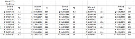
The mean temperature for the month finished 0.7C, the 14th coldest January in London back to 1797. Just 5.1mm of precipitation was recorded, the second driest January in the series. Screen Shot 2018-01-06 at 22.31.39