A few years ago I devised a winter index to try to decipher how modern winters ranked against legendary seasons, such as 1947 and 1963.
With the media hyping conditions last week, which were severe in many parts of the country, it is very difficult for many to gauge just how conditions compare with previous winters.
My findings show that this winter so far stands 27th. It is possible that further snowfall that results in lying snow at 9am between now and April will boost the position higher though, given recent years, this would seem unlikely.
Last week’s cold spell, while containing some impressive statistics, is put into perspective when it is compared with other severe spells since 1960. A decent cold spell but no record breaker in the form of a 1962/63.
Perhaps it is the advent of social media, the plethora of constant updates of the latest feet-deep snowdrifts and instant tales of heroism in the face of icy adversity, that has made this cold spell seem far more severe than it actually was in the minds of many; February / March 2018 was the first truly social media-driven cold spell.
The winter of 2017/18 will probably be remembered as much colder that it actually was – the exceptionally severe spell right at the end was only at its halfway point by the time the meteorological winter was over.
Like a scene from the Pathfinder movie
The mean temperature for the season finished 5C, that’s 0.5C below average and the coldest for five years.
Rainfall was above average: 180.8mm fell, that’s 124 per cent of average and the wettest for four years.
Sunshine was just over average: 174.4 hrs is 104 per cent over average and the sunniest for tree years.
As so often with winters at this latitude the average for three months makes it look a non-descript season – it is only when you look at the detail that compelling facts emerge.
The coldest day of the season occurred on the last day of February when the maximum failed to rise above -1C, the first ‘ice day’ for five years and the coldest day since 2010. It was also the seventh equal coldest February day in a local record going back to 1959.
Perch pond, being deeper, took longer to ice over
The coldest night of the winter was in the early hours of the 28th when a low of -6.9C was recorded. The temperature would have been far lower were it not for a shower that moved in at 3am.
The warmest day of the winter occurred on December 30th with 14.2C recorded. The warmest night was on January 28th when the temperature fell to just 10.8C.
The wettest day of the winter occurred on January 2nd when 15.3mm was recorded.
Snow arrived at the start of winter and at the very end: seven days of snow falling and four days of snow lying over the three months is below average.
This slideshow requires JavaScript.
The daily mean temp yo-yo’d throughout December, January and February
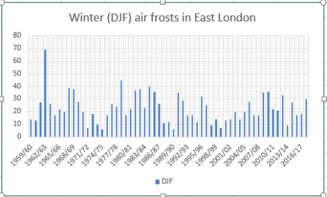
There were 30 air frosts during the three months, eight above the 1981-2010 average.
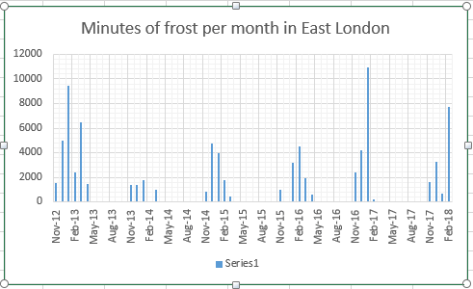
There were 11,680 minutes of frost over the winter, less than last year, though 66 per cent of those were recorded in February. Considering the past 6 Februaries this year’s frost hours were 170 per cent greater than the next highest, February 2016!.
Temperature (°C):
Mean (1 minute) 5.2
Mean (min+max) 5.0
Mean Minimum 2.0
Mean Maximum 8.0
Minimum -6.9 on 27/02/2018
Maximum 14.2 on 30/12/2017
Highest Minimum 10.8 on 28/01/2018
Lowest Maximum -1.0 on 28/02/2018
Air frosts 30
Rainfall (mm):
Total for period 182.2
Wettest day 15.3 on 02/01/2018
High rain rate 28.2 day 02/01/2018
Rain days 52
Dry days 38
Wind (mph):
Highest Gust 45.0 on 02/01/2018
Average Speed 3.7
Wind Run 8059.5 miles
Gale days 0
Pressure (mb):
Maximum 1036.4 on 22/12/2017
Minimum 970.3 on 10/12/2017
Days with snow falling 7
Days with snow lying at 0900 4


You must be logged in to post a comment.