Category Archives: Air thickness

Thunderstorms 26th-27th May 2018

Last night’s intense thunderstorm was probably most notable for its high-level sheet lightning than rainfall, thunder or fork lightning.

At my own station I recorded 4.8mm of rain which at its heaviest fell at a rate of 24.1mm/hr at 0046. To put that into perspective that’s just under a quarter of the rainfall rate during the thunderstorm at the beginning of last June. Rainfall in nearby Woodford Wells fell at a rate of 35.6mm/hr at 0040.

The rainfall was much heavier to the west of London. Screen Shot 2018-05-27 at 13.06.37

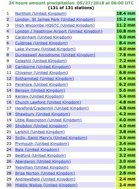
Also of note was how warm the night was. A low of 15.3C made it the 8th equal warmest May night since 1959.

There’s probably going to be a few more storms this bank holiday weekend though it remains to be seen whether this is going to be a classic summer for storms.

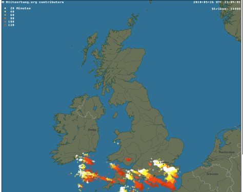
At it’s peak at 2305 there were 16800 strikes, according to Blitzortung.

Lightning from the storm in the early hours of the 27th caused a fire at a house in Romford.

There is an account of the family’s ordeal here.

Screen Shot 2018-05-27 at 15.13.10

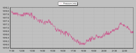
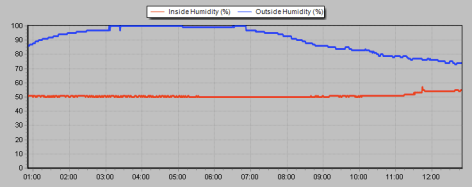
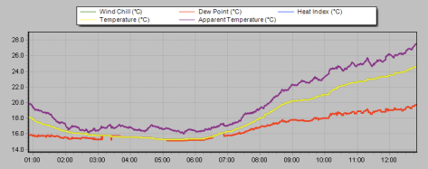
Here’s a few traces from the station.

Screen Shot 2018-05-26 at 23.39.37

Screen Shot 2018-05-27 at 12.51.20

Screen Shot 2018-05-27 at 12.51.37

Screen Shot 2018-05-27 at 12.52.18

Around the capital and the south east

Elsewhere in London there was some excellent footage posted on social media.

Screen Shot 2018-05-27 at 13.03.15


The 27th was fairly quiet but with abundant sunshine and little wind it wasn’t long before more storms, this time homegrown, developed over the Midlands and the south. Severe flash flooding was reported in the Selly Oak area of Birmingham after a month’s worth of rain fell.

And as dusk approached a huge storm toward to the north-west of London and Chilterns. With little wind the storm stayed more or less in situ, expending all its energy with the most amazing lightshow – lightning within cloud that became more and more vivid as darkness approached.

Because these storms can reach heights of 29,000ft – roughly the height of Everest – they can be seen from over 40 miles away.

I had a go myself.

Screen Shot 2018-05-28 at 10.34.52

Not bad but the best footage I’ve seen was captured by Simon Cardy from east London and can be seen here.


I also took this video.

Advertisement

Record cold pools and snowfalls

This week has the potential to see new temperature records set or matched as very cold air moves in off the continent.

Whilst amounts and location of snow are very difficult to estimate at more than 24hrs to 48hrs away there is no doubt that the incoming air is very cold indeed.

In the early hours of Wednesday one weather model is showing extremely cold air (496-504 DAM ie very low thickness) just off the coast of Scotland. In the last 60 years there have been only three occasions where air approaching this thickness (500 DAM and lower) has been recorded in the UK:

February 1st 1956: Hemsby, Norfolk
February 7th 1969 at Stornoway, Outer Hebrides
January 12th 1987 at Hemsby.

thick
Radiosonde (weather balloon) ascents will make very interesting reading this week

With the deep cold air in place the potential for snowfall comes once the air starts to become unstable. East London, and much of the east coast, best falls come where convergence lines ‘streamers’ form.

streamer
One example of a streamer is forecast to occur on Tuesday

If persistent, these ‘Christmas tree’ features are capable of producing snowfall accumulating at the rate of 5–7cm per hour in especially cold
outbreaks, albeit often very locally. The steep thermal contrast between the very cold air and the current warm anomaly in the North Sea could make any snowfall very heavy indeed.

Streamers during the cold spell of January 1987 saw 30cm fall widely with some up to 65cm in Kent and 45cm in south Essex. Parts of Cornwall saw up to 40cm.

During a cold spell in February 2009 thundersnow was recorded – the favoured spot this time being parts of Surrey which saw 30cm.

Personally the most snow I have recorded during a cold spell was in February 1991. A very deep cold pool, not unlike what is forecast this week, covered much of the south. in air approaching 500 DAM. Days and days of snow followed dumping knee-deep powder in my local park in suburban East London. Reported depths included 20cm at St James’ Park in the centre of London, and 38cm at Rettendon, Essex.

There is a very good paper on cold pools and snowfall here.

beast