With talk of an imminent statospheric sudden warming (SSW) I thought it would be interesting to have a look back at previous SSWs and see what precedents could be found.
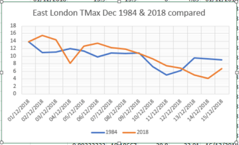
December so far is showing similarities with 1984: mean maxima is within 0.3C of 1984 while rainfall is virtually the same at around 30mm!
During the winter of 1984-85 the polar vortex split on January 2nd, setting up that month to be among the coldest of the 20th century, on a par with 1979 and 1987. A more recent January that was just as cold was 2010.
Indeed, the winter of 1984-85 was among the snowiest of the past 70 years, ranking at number 5 in my survey of winters.
Since notably cold weather struck at the end of February I’ve lost count of the number of times I’ve heard this phrase uttered by the public and some sections of the press.
Top 20 cold anomalies
The ‘Beast from the East’ (versions 1.0 and 2.0) really captured the imagination in an age where everything has to have a label slapped on it; any message that these cold spells are ‘weather’ and not ‘climate’ seems to get lost.
Both spells, indeed the general pattern of our late winter weather, were driven by the stratospheric sudden warming event that lead to a split polar vortex in February – leading to a very cold end to the month and a mean temperature anomaly of -2.5C, the greatest monthly anomaly since March 2013.
To put it into perspective, however, it was nothing like some of the anomalies that occurred in the early 19th century: January 1814, for example, saw a monthly anomaly of -8.2C and coincided with the last occasion a frost fair was held on the Thames. Januaries back then were generally very cold, the 1801-1831 average monthly mean was -3C, that’s 8C colder than the most recent 1981-2010 average!
So climate now is much warmer but that is not to say that anomalously cold months can’t happen. February 1986 saw an anomaly of -5.6C, the 13th= greatest cold anomaly in my local dataset going back to 1797.
Top 20 warm anomalies
The cold December of 2010 recorded an anomaly of -4.2C, 76th= greatest cold anomaly, while anomalies of -4.1C recorded in January 1979 and March 2013 were 77th=.
With the warming climate it is no surprise that most warm months happened very recently. The balmy month of December 2015 Â saw a positive anomaly of 5.4C.
The ‘Beast from the East 2.0’ was caused by a narrow tongue of extremely cold air from Russia scoring a direct hit on the UK. The odds of this happening must have been low but it is an example of how, when the synoptics of the atmosphere line up perfectly, anything is possible.
And it is an example how even in a warming climate the UK can still be subject to anomalous cold and warmth at any time of the year.
As the author Mark Twain reportedly once said: “The climate is what you expect; the weather is what you get.”
The upper air anomaly of the ‘Beast from the East 2.0’. This graphic shows positive and negative monthly anomalies since 1797 against a generally warming climate
Because the above graphic is crowded I created one of anomalies since 1970. The upward trend is the same.
‘This cold spell is rubbish compared to what we used to get!’ Every winter when weather model hype builds expectation for many, often days in advance, the outcome never seems to quite match the hype.
This expectation among weather nerds is inflated even further when the tabloids cotton on and build anticipation further only for it all to end in a ‘damp squib’.
I’ve lost count of the number of times when excited enthusiasts proclaim that an incoming cold spell is going to last at least three weeks; the reality being that the intensity of the cold has gone after four or five days. Cold spells since 2008 often arrive as a ‘blob of cold air’ from the continent that eventually gets ‘warmed out’; it’s been a very long time since we had a cold spell that’s been fuelled by a continual feed of air off the continent.
In 2018 the really cold air aloft had warmed after 5 days
To illustrate my point I had a look back at every cold spell in this area of suburban east London since 1960. I weeded out the feeble efforts of the last few years by only considering spells where the maximum didn’t exceed 2.8C. The results spanned from the most recent cold spell of February 2018 to the mammoth 31-day Siberian blast that began on Boxing Day 1962.
In another blog I remarked how similar the 2018 pattern was to February 1962. This cold spell began on the 26th and lasted 9 days. Some 7cm of snow fell, this drifting in the wind, possibly making it seem worse with only 4 hours of sunshine which would have maintained any snow cover.
One of the snowiest cold spells happened in February 2009, eight days after an SSW event that lead to a polar vortex split. This four day spell saw a total of 26cm of snow fall.
There’s been much anticipation regarding the forthcoming sudden stratospheric warming (SSW) event with many hoping that a resultant split vortex will result in unseasonably cold weather in the UK and… copious snow in the low-lying south-east.
An SSW event, which reverses winds high up in the atmosphere from a westerly to easterly, can downwell into the troposphere, bringing weather from a (usually) cold continent instead of the warm Atlantic.
While a split PV event is usually more conducive for cold weather in the UK, as opposed to a ‘displaced vortex’, which usually favours only the eastern US, it is by no means a guarantee of a cold pattern subsequently evolving.
Using results published in the paper Tropospheric Precursors and Stratospheric Warmings (Judah Cohen and Justin Jones), along with meteorological data for east London, I set out to find what influence past warmings had on the weather in the capital.
Looking 45 days either side of the central date for vortex splits gave the following, chaotic graph.
But every year is different. And there appears to be more likelihood of an SSW making a difference, in terms of prompting a colder pattern, the earlier in the winter it occurs.
The SSW in 1985 was followed by a 45-day mean temperature anomaly of -3.8C! If you look at a shorter timescale, 15 days after a split PV and the anomaly is -10C on January 16th: -4.9C is the second coldest January day in Wanstead of the past 60 years.
At the other end of the scale the SSW event on March 23rd 1965 was followed by a POSITIVE anomaly of 3.4C. Perhaps solar influence this late in the year can override any SSW? Elsewhere, however, according to the website london-weather.eu: “3rd March – A combination of deep snow cover and clear skies allowed minimum temperatures to fall below -21C in northern Scotland.”
During another SSW in 2001 results in London were fairly unremarkable though heavy snow fell in Ireland.
This graph shows a general downward trend in the 15 days following an SSW event
The other result to consider is the influence from ENSO. It seems that when La Nina is ‘too negative’ this can ‘overcook’ proceedings and actually leave our part of the UK with a positive anomaly, as this table shows. It should be noted, however, that thicker Arctic ice in the 1960s would also possibly have had more influence than now.
There hasn’t been a full SSW event for years. The impact this one will have on our weather in London, a tiny part of the globe, is impossible to quantify. Though the latest model output is encouraging for anyone looking for a chilly end to winter.
Over the past few days there has been a lot of speculation on the possibility of a sudden stratospheric warming event happening. These events can contribute to unseasonably cold snaps in winter though exactly where their effects happen on the globe is impossible to forecast at small scale resolution.Â
In short it looks like the eastern US is most likely to see any severe cold weather from this episode – what seems to happen a lot in recent winters in the UK.
Far from being an expert on this there was a very good posting on the usenet forum uk.sci.weather by Stephen Davenport.
“A temporary wind reversal is likely in the upper stratosphere; for example, see ECMWF at http://www.geo.fu-berlin.de/en/met/ag/strat/produkte/winterdiagnostics/, and have a look at the off-the-chart EPV (although not so much poleward). However, I do not see this as a major SSW (by definition) and everything points to a recovering but weaker circumpolar vortex mid-month onwards.
“That opens the door to Arctic air pouring far southwards, and there’ll be snow chances at least as far south as the Tennessee Valley. Incidentally there is a risk of another Nor’easter around Feb 9th-10th.
“Downstream a mid-Atlantic ridge could build rather strongly from the subtropical high towards Greenland with slowed zonal flow but most likely surface low pressure developments eastern Atlantic / near the British Isles.
“If the long wave pattern shifts a little eastwards then the increased meridionality *could* see LP progression pull in temporary subsequent N-NW flows for the UK – a more likely route to short-lived cold shots than via any high latitude blocking in the medium range.
“I think that elsewhere people have got hung up on the stratospheric warming and, as so often, drawn excitable conclusions. Cold impacts are more likely for the eastern U.S. than Europe with a displaced rather than a split vortex; and the circumpolar vortex was so strong first half of winter it was always going to take a lot to break it down fully. And sure enough, as noted there should be a recovery after this “attack”. You can see the vortex distortion and latterly the beginnings of recovery in this rather nice animation of 10hPa potential vorticity:
“GFS has occasionally pulled out a split vortex at various levels during the past week but doesn’t now.
“That’s not to say that a possible further warming (early final warming?) wouldn’t bring colder chances from the end of February into March.
“I was surprised to read recently that a well-known online forecaster had predicted significantly cold/blocked conditions for Europe in January via a major SSW. A bit premature, that.”
You must be logged in to post a comment.