When it comes to explaining weather phenomena the British media has often been found wanting over recent years. But when the Australian Bureau of Meteorology yesterday confirmed the emergence of a fresh El Niño newspapers and TV stations inevitably reached the conclusion that the phenomena will trigger a severe winter in the UK.
Sky News told us that it “could also result in a harsh winter for the UK; during the last El Nino in 2009/10, Britain suffered heavy snowfall”, before showing us newsreels of what looked like conditions in December 2010 – the winter after.
I decided to have a look at the facts to see what the effect of an El Nino episode was by comparing the US weather agency NOAA’s data on ENSO episodes going back to 1950 with my own data. For speed I used my top ten snowy winters and compared against the NOAA data. The results showed that eight cold winters followed an ENSO pattern that was negative. The winter of 2009-10 seems to be the exception to the rule. Indeed, a significant El Niño episode in 1997/98, preceded the third warmest winter in my series going back to 1797!
El Niño / ENSO is just one variable when it comes to forecasting a season ahead. Other variables to consider are AO, QBO, MJO and this is before SSWs, sudden volcanic eruptions and sunspot activity throw spanners in the works.
It is exasperating that both the Sky and Telegraph stories were copiously shared on social media – prompting the inevitable comments along the lines of: “They’re talking rubbish, they can’t forecast what that weather will be tomorrow!”
But rather than badly informed journalists it is the Met Office and other noble agencies who will share the blame if the story is incorrect.
There is no doubt that El Niño will disrupt the weather around the Pacific rim but, considering the data we have available, I don’t think it, alone, will be the reason Britain may experience a severe winter this year.
** NOAA’s monthly diagnostic discussion just released (14/5) says:
“There is an approximately 90% chance that El Niño will continue through Northern Hemisphere summer 2015, and a greater than 80% chance it will last through 2015.”
This January saw the first falling snow in nearly two years with the last three days of the month seeing the first flakes of winter – nothing much to write home about by average winter standards.
Cold front clearance over Wanstead Flats on 28th. The day saw three potent cold fronts with steep temperature falls.
Mean temperature for the month was 5C, 0.2C below the 1981-2010 mean – the first below average month since August and 1.6C cooler than the mild and stormy January of last year.
Rainfall of 69.2mm was 130% of average – though over 60mm less than last year’s record-breaking wet January.
It was the 6th sunniest January on record in my series going back to 1877. Over 73 hours of sunshine was recorded in this area which is 147% of what we can expect to see during an average January.
The wettest day occurred on the 12th with 13.1mm.
Air frosts: 11
Ground frosts: 14
So what has February got in store weatherwise? The general consensus of the models suggest the first half of the month is going to be on the cold side and relatively dry though there is a chance of some precipitation from troughs forming in an unstable airflow off the North Sea. Pressure looks like it will build from Wednesday, blocking any advance of Atlantic weather systems. It is the location of the high which will be crucial to the weather we can expect. At this time of year anticyclonic gloom can be a problem during the day and where clouds clear at night fog and frost may form.
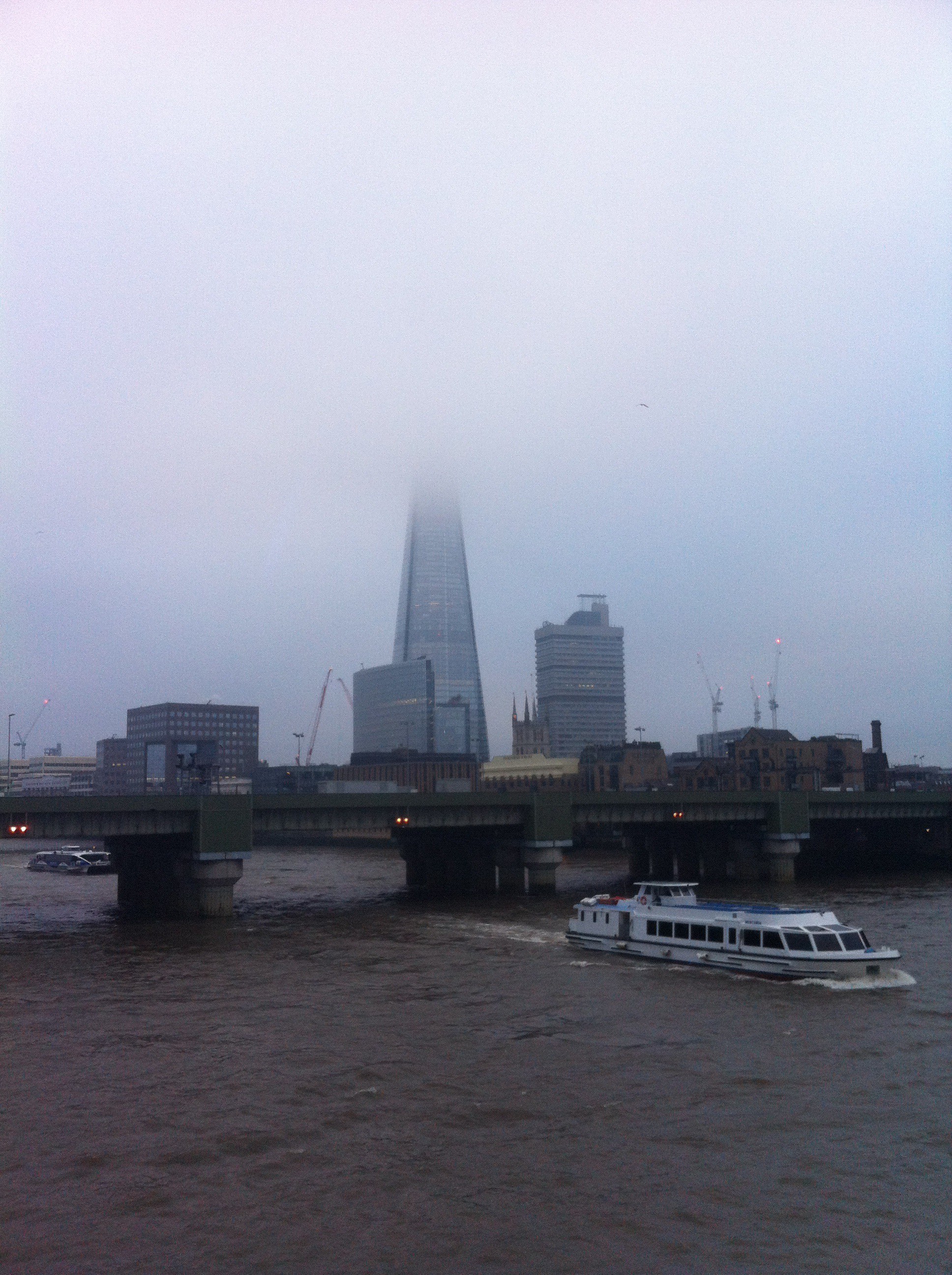
The Shard in fog from Southwark Bridge on January 4th
Beyond that, for anyone seeking any snowy weather, the outlook, as ever, is uncertain. Using a similar method to my Christmas forecast, which was correct at 25 days ahead and my January outlook, I’ve had a look back in the archives to see if there is any precedent in the pattern we’ve had this January.
There appears no chance of a very mild February. The strongest signal (72%) is for an average to rather cold February. The strongest signal for precipitation is for very dry (50% of average) at 43%. After the disappointment of the last week here regarding snow I am not about to guess if there will be any snowfall for us this coming month. If we do see any though I would imagine any cover will be thin and lasting only a day or two…
2nd Sunny most of the day before cloud spread in in the evening and rain fell just before 4am.
3rd Mostly wet with moderate bursts of rain on what was a cold and miserable day – the fields between Grays and Basildon were flooded.
4th Skies cleared early morning with fog and mist forming to give a cold, grey day and a maximum of only 3C – some parts of East Anglia recorded an ‘ice day’. The temperature started to lift at midnight on 5th meaning that day 5s ‘high’ temperature was at 8.32am on 6th.
5th Cloudy and very calm up to midday.
6th rain at midday as cold front passed through, bright and sunny spells and brief frost at 1am. Cloud moved in.
7th a sunny start though chilly, cloud built through the morning. Light rain around 7pm and through the evening. This turned heavier at 4.30am and really got going at 7.30am.
8th Heavy rain to start, this easing at 11.30am before the sun came out at 1pm to give afternoon of sunny spells. Brief rain again around midnight.
9th Bright start, wind building through the day as storms struck off north Scotland. Very mild in the warm sector: +15.2C at 8pm. Shetland badly affected by cloud head in early hours. Windy through the night.
10th Bright start though cloud built quickly with cold front passing through around 10am. Dew point dropped from 11C to 3C in matter of hours. Felt very cold in the wind.
A storm passed over Shetland on January 10th
11th Sunny start, clouded over by 2pm with temp building through day and odd drizzle.
12th Cloudy start with spits and spots of rain up until 2pm.
13th Sunny until lunchtime . Clouded over though with some light rain. Thunderstorm reported in Bracknell and snow reported above 125m in Wales Lampeter.
14th Sunny start but lots of cloud from embedded instability in the airflow. Temperature rose all day with drizzle at 6pm. Pressure bottomed out at 985.3mb at 0345z. Peak gust 21.3mph at 0320z. Rain heaviest at 0412z 12.1mm/hr
15th Sunny start with lots of cloud around, feeling cold in the wind
16th Cloudy and much calmer
17th Cloudy start with threat of snow showers at 11am, remained as rain though snow reported at Berkhampsted and Watford. Pleasant day with sunshine.
18th Mostly cloudy in morning but with weak sunshine. Temperature plunged after dark but cloud prevented further cooling at midnight.
A warm sector saw the temperature rise to 12.7C in the early hours of New Year’s Day
19th Sunny , cold start with a few clouds. Frost returned at 6.40pm with coldest night since Jan 2013.
20th Sunny start but took till 11am to rise above freezing with some frost lingering well into the afternoon. Snowflakes reported at Laindon and dusting in parts of Kent. More general snow PM from Chilterns northwards – too warm here.
21st Cloudy, dull and cold all day with some drizzle. Snow reported in Laindon. Dull and cold in Reading.
22nd Hazy sun to start, sunny spells all day. Very cold overnight
23rd Sunny start with high alto-cumulus. Gradually becoming more cloudy though staying bright. Temperature started rising after dark with approach of warm front. Temp peaked at 2am as cold front whistled through with brief heavy rain. Sunny again by dawn.
24th Sunny with occasional cloudier spells. Feeling cold in the wind.
25th Sunny start but gradually clouding over. Temperature climbed through the day and night. Drizzle in the wind.
26th Cloudy with bright periods. Temp and dew point started falling after 10am with passing of warm sector.
27th Hazy sun to start then wintry sunny spells all day.
28th Cloudy start quickly gave wave to at least three potent cold fronts with steep temperature falls. <5mm hail in the last and thunder heard in Woodford Green. Clearer spells overnight and possibly spots of rain.
29th Sunny, cold start . Clouding over with potent shower at 4.30pm that gave a brief covering of snow pellets. Snow and sleet at 9.30pm but no accumulation here. Snow falling.
30th Cloudy, cold and damp day with some drizzle pm. Lots of snow in Derbyshire – one report of 41cm. Reports of snow falling in the early hours at Hollow Ponds. Snow falling.
31st Cloudy with intermittent light rain through day. Reports of snow in north Essex and Southend. Some sleet in the early hours
This December was the sunniest on record in my series going back to 1877. Over 90 hours of sunshine was recorded in this area which is 224% of what we can expect to see during an average December.
It was the sunniest December on record in the series going back to 1979. Some 11 mornings were completely clear at the 9am observation time
Mean temperature for the month was precisely average at 5.6C. Rainfall of 39.9mm was 75% of average – the driest since 2010.
The month was 0.7C cooler than last December – with just under half the rain that fell in that wet and stormy month.
The first day of December was cloudy, dull and dreary with drizzle in a keen east wind. The following days alternated between rain and sun and some night frost. On the 6th the day started sunny with just a few cirrus clouds – overnight frost persisted all day in my garden with a grass min at -2C. The 9th began sunny after a hard frost but then the temperature climbed for 19 hours with cloud building and brief rain at 2am before the cold front passed.
The wettest day occurred on the 11th. The day started sunny but blustery showers blown in on strong WSW winds coupled together with 6 hours of rain overnight produced 11.5mm.
Things turned much milder in the 3rd week with frequent, chiefly light rain, abundant sunshine and an absence of frost. On the 18th the temperature reached 14C.
Christmas Eve saw the weather begin to cool down again with progressively colder nights. Boxing Day was a cloudy, cold day with rain spreading in during the evening and a notable warm sector raising the temperature to nearly 9C at midnight. The first lowland snow of the winter was reported up north. The month ended with long sunny days and sharp frosts, a couple persisting through the day.
Air frosts: 12
Ground frosts: 15
This satellite picture taken on December 27th, 2014, shows the LP clearing through to leave us in clear, deep cold air
From this month, using a similar method for predicting winter, I am going to finish these monthly reviews with a look ahead to see what next month has in store.
The general consensus of the models suggest the first half of the month is going to be mostly unsettled with a mixture of wind and rain off the Atlantic and transient ridges from the south bringing mild, sunny days.
Looking at the 10-day ahead forecast on Netweather suggests the temperature will be just above average with rainfall also slightly higher than normal.
Beyond that, for anyone seeking any snowy weather, the outlook is uncertain. Using a similar method to my Christmas forecast, which was correct at 25 days ahead, I’ve had a look back in the archives to see if there is any precedent in the pattern we’ve had this December.
The simple answer is there is no over-riding signal for any weather type, save that there appears no chance of a repeat of the very mild January of last year. Taking all the probabilities together gives an 88% chance that January will be average to cold – so perhaps there will be some snow in the second half of the month.
Just over 140 years ago The Grotto in Wanstead Park was destroyed by fire.
An account of the fire appeared in the November 29th edition of the Essex Newsman
The building, once part of the grand estate, was being used as a store room since the park’s acquisition by the Corporation of London. The fire, according to a local report at the time, initially started in a cottage adjacent to the Grotto and was discovered about 9 o’clock on November 20th 1884 by a man who had been walking through the park.
Mr G. H. Sparrow, of Latimer Road, Forest Gate, raised the alarm with Wanstead Fire Brigade who, despite arriving quickly, were too late to stop the fire spreading from the cottage to the Grotto. Their efforts were further hampered because the Ornamental Water was being cleansed – a supply of water was 250 yards distant from the River Roding, a fact that cost precious minutes.
By the time the fire was subdued the place was entirely destroyed – only the outside walls and entrance remained intact, probably more or less what you can see today.
The building was composed of shells, pebbles, fossils, rare stones, looking glasses and “a fine painted window that was built at an immense expenditure by the Countess of Mornington”. Its destruction removed the only remaining monument of what was once one of the great estates in the Eastern Counties.
The Grotto seen from across the Ornamental Water
I’ve often wondered if the weather could have played a part in the demise of the Grotto. The monthly average for November, however, suggests not. A mean of 5.7C is on the cold side compared with recent Novembers and although it was a dry month with 45mm of rain – that total is nothing out of the ordinary for the time of year.
Conditions on the day were bright though chilly, the temperature only rising to 7C after an overnight low of 2C. Perhaps one contributing factor was the north-westerly breeze which would have helped drive the flames through the structure.
One could also point to the fact that Ornamental Waters had no water to douse the flames as it was being cleaned. Though the fact that it was empty is nothing new as the entire lake system had retention problems from the park’s inception.
Perhaps it is a case that fires do just sometimes happen regardless of how careful we are in preventing them.
It is sad that bad luck seemed to hit the Grotto just like it saw the demise of Wanstead House decades before.
Save for the warmest Hallowe’en on record and a notable depression on the 21st October was a relatively quiet month.
The month was warmer than average; the mean temperature of 13.7C was 1.9C above average, making it the 5th warmest October since 1797: 0.7C warmer than last October, though only the warmest since 2011.
The dry and sunny start was replaced with a very unsettled regime at the end of the first week which lasted until the end of the second week – with 39.5mm of rain falling over the 12th and 13th, a notable total for this region. It was wetter than average: 82.4mm represents 123 per cent of what we’d expect to fall in a normal October.
Despite it being wet it was only the 74th wettest October in the series back to 1797.
The warmest day occurred on the 31st with 21.5C recorded. Many nights were warm with date records matched or broken. Cold nights, relative to the time of year were few. The lowest temperature occurred on 4th when the mercury fell to 2C – a ground frost was narrowly avoided with the grass minimum thermometer falling to 0.2C.
Sunshine was slightly below average with 103.6 hours recorded – that’s 97 per cent of mean. The sunniest day was on the 5th when 9 hours of sunshine were recorded.
In terms of weather events September was a relatively quiet month save for the two thunderstorms that seemed to mark the Scottish Referendum as the results became apparent in the early hours of Friday 19th.
Clouds above could be seen developing rapidly at 2.30pm on 19th September
September 2014 was warmer than average; the mean temperature of 16.4C was 1.1C above average, making it the 16th warmest September since 1797: 1.6C warmer than last September, the warmest since 2011.
The month was marked with lots of dry, sunny days, the two thunderstorms on the 19th contributing 89 per cent of the rainfall for the month. It was dryer than average – the 44.8mm that fell is 86 per cent of what we would expect in a normal September.
Despite this it was only the driest September here since 2011.
The warmest day occurred on the 18th with 25.6C recorded. Most nights were warm though a couple of nights were chilly: 5.4C was recorded on 24th
Sunshine was below average with 126.9 hours recorded – that’s 91 per cent of mean. The sunniest day was on the 8th when 12 hours of sunshine were recorded. There were 2 days with thunder recorde.
It was just before 3am that I was awoken by faint rumblings outside. I knew there was a risk of thunder before I’d retired to bed a few hours earlier but I’d discounted the risk along with any thoughts of staying up to watch the referendum results unfold in Scotland.
This radar shot shows the storm just beginning to hit Wanstead. The rain was far heavier to our east. 17.2mm was reported at Laindon, Essex. An observer at Woodford Wells recorded 19.9mm her in about 25 minutes 0310-0335 bst
Lightning then illuminated the room through the gaps in the curtains followed by more rumblings: it’ll pass, I thought. Crash – I grabbed my phone – was this an isolated event? The radar showed a line of slow moving storms moving up from the south. More lightning and loud thunder. My Twitter feed told me it wasn’t going too well for those wanting independence. At this point intensely bright lightning was rapidly followed by one of the loudest claps of thunder I’ve heard around 3.10am. Car alarms were set off – may as well get up I thought… The Inverclyde result was announced – ‘No’, by the narrowest of margins 50.1% to 49.9%. That’s it then, I thought. The lightning and thunder gradually began to fade away with hopes of an independent Scotland, on this night anyway. I glanced at my stats which seemed far less impressive than what was recorded elsewhere: 7.7mm, no big fall in temperature or pressure like previous storms during the summer.
Just a few hours later I walked my younger daughter into school, my bleary eyes struggling to focus – the humid and steamy atmosphere felt more like July than September. Indeed Thursday had been the warmest September 18th since 1997 which, strangely, was the same year that another momentous British event took place: the handover of Hong Kong to China. I remarked to a couple of parents that the only thing that had changed overnight was that Andy Murray will forever be the “Scottish” tennis player after his comment on Twitter.
The forecast advised that there was a continued threat of thunderstorms. It was humid but it didn’t ‘feel’ stormy – though around 2.30pm I could hear the beginning of faint rumblings in the distance.
Clouds above could be seen developing rapidly at 2.30pm
I left for work on my scooter at 3pm, carefully watching the sky for any developments all of which seemed to be in the distance. After stopping for petrol in Leytonstone High Road huge drops of rain began splattering the pavement. They were few and far between, however, and the sun defiantly continued to shine. After riding past Stratford I suddenly became aware that the buildings in the distance, past Bow flyover, were gradually beginning to disappear. I pulled in to a turning where Gala Bingo is situated. An electronic noticeboard enquired: “Do you feel lucky?” Not today I thought and retrieved my overtrousers that live under the seat, hastily pulling them on as I watched the impending storm begin to close in.
I continued on and was soon enveloped in the full force of another thunderstorm. Marble-sized hail clattered off my crash helmet while dangerous gusts, caused by wind funneling through the new high rise flats by the Olympic Park, did their best to push me off. Just as I crossed the canal a sheet of rain engulfed me and the drivers to my right. The road in front suddenly turned into a shallow river. I usually ride over the flyover – not today with the torrent of water cascading off the sides.
The 3.15pm storm that flooded large parts of East London. The white area shows where the heaviest rain was
By the time I reached Mile End the rain had almost stopped. The City looked fairly dry and on reaching London Bridge the roads were completely dry. The Friday crowds were out in force in Borough Market, enjoying the sunshine and seemingly oblivious to the chaos unfolding just a few miles away in East London. Within 10 minutes of walking into my office Alex Salmond announced his resignation. Another storm: another momentous event! It was another of those coincidental storms that, in my mind, seem to mark momentous events such as the Royal birth last July
I checked the stats of the storm back in Wanstead: 24.5mm fell with a peak rate of 76.5mm/hr at 15.47. The storm ended a run of 16 dry days bringing the total for the month up to 33mm – the 24hr total was 30.5mm. The explosive convection of this storm can be seen here. The associated hail and rain brought much flooding to Hackney, Hackney Wick and Leytonstone. This storm seemed to be the result of a convergence line over London between light southerlies to the south and easterlies to the north – the heavy rain was very localised.
The flooding wasn’t restricted to East London. In Southend water started pouring through the roof of the Dixons theatre though it failed to stop the performance. Shops in London Road were inundated.
Anyone hoping for a continuation of June and July’s hot weather would have been left sorely disappointed by last month which was characterised by frequent rain and the coldest August night for over 20 years.
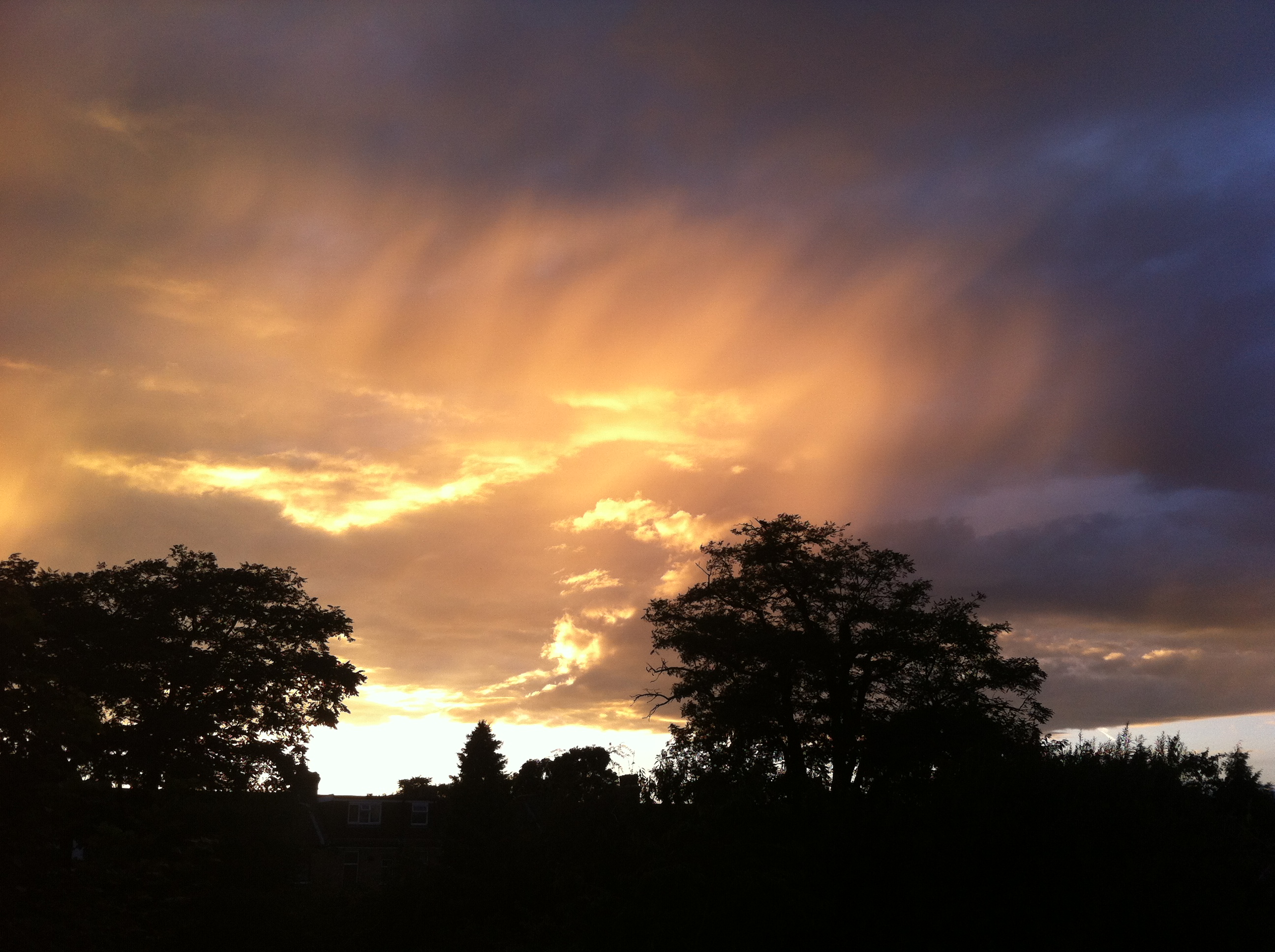
A stunning example of sunlight illuminating the underside of cloud at sunset was seen mid-month
August 2014 was the first month this year to be cooler than average; the mean temperature of 17.2C was 1C below average, making it the 89th warmest August since 1797: 1.6C cooler than last August, the coolest for 7 years.
The month was marked with thunderstorms and heavy downpours, contributing to what was a much wetter than average month – some 76mm fell which is 152% of the monthly average and the wettest for 4 years.
The hottest day occurred on the 7th with 27.3C recorded – nothing special for August and a date that heralded the end of the hot spell during June and July.
A couple of nights were notably cool for August: 5C was recorded during the early hours of the 23rd – the coldest August night since 1993.
Sunshine was below average with 161 hours recorded – that’s 83 per cent of mean. The sunniest day was on the 3rd when 12 hours of sunshine were recorded. Throughout the month there were just 2 days with 10 hours or more of sunshine. There were 4 days with thunder recorded – the average for August is 3.
Looking further afield there were many thunderstorms around the UK though many places missed out on the big downpours. It was yet another month where rainfall totals could vary greatly in the space of just a few miles.
On the 9th a station in Woodford Green recorded 24.4mm, double what fell in Wanstead. The legacy of TS Bertha coincided with the end of our extended hot spell – an excellent analysis of this storm can be found here.
There were some spectacular cloud formations not far from here. A particularly good one was seen in Witham.
On 25th a perfect curl could be seen on a depression centred off the west coast of Irleland. The rain associated with this low pressure brought the month’s highest daily rainfall total: 23.4mm (the system bringing 27.5mm) – a thoroughly miserable Bank Holiday Monday where it rained ALL day, from 6am until 9.30pm. It was yet another example of how much even frontal rainfall can vary over a small area.
On 25th a perfect curl could be seen on a depression centred off the west coast of Irleland. The rain associated with this low pressure brought the month’s highest daily rainfall total: 23.4mm (the system bringing 27.5mm) – a thoroughly miserable Bank Holiday Monday where it rained ALL day, from 6am until 9.30pm. It was yet another example of how much even frontal rainfall can vary over a small area with St James Park recording 38.2mm. The top 30 totals for that day can be seen here.
sunset overlooking Wanstead Flats 2nd August
Looking even further afield four people were killed in a flash flood at an Italian festival early on in the month.
July 2014 was yet another milder than normal month; the mean temperature of 20.2C was 1.7C above average, making it the 9th warmest July since 1797 – and 0.5C cooler than last July.
The month was marked with spectacular thunderstorms and torrential downpours, contributing to what was a much wetter than average month – some 73mm fell which is 168% of the monthly average. While on paper the month looks very wet it should be noted that 52% of the July total fell in two episodes: a stalling warm front on the 10th and a cloudburst on 25th. I was away for the thunderstorm though a friend remarked that the roads close to Redbridge Roundabout were like torrents, the rain was so intense for a short period. I’ve put together a series of radar images that show the evolution of the storm, together with graphs, that can be accessed here.
The hottest day was July 18th with 32.7C recorded. There were 12 occasions where the mercury reached or exceeded 80F – pretty respectable though last July saw that figure reached on 20 days!
The sunniest day was on the 3rd when 15 hours of sunshine were recorded. Throughout the month there were 11 days with 10 hours or more of sunshine. There were also 5 days with thunder recorded – the average for July is 3.
Looking further afield there were many thunderstorms around the UK though many places missed out on the big downpours. Perhaps the most impressive was the development of the MCS that moved up from France during the evening of July 18th. There were numerous superb pictures but my favourite is probably this shot taken by Richard Dixon in Whitstable, Kent. It shows, perfectly, the contrast betweeen the bright orange sunset and the impending doom of the approaching MCS from the continent.
This shot was taken by Richard Dixon in Whitstable, Kent. It shows, perfectly, the contrast betweeen the bright orange sunset and the impending doom of the approaching MCS from the continent
A thunderstorm on Sunday, July 20th, saw three inches of rain fall on Canvey Island in a very short space of time. A good round up of events, including pictures, can be seen here. The thunderstorm on 25th was felt across London and the Home Counties – there’s an excellent picture of the approaching shelf cloud here. Brighton was rudely awoken by a storm on 28th by a slow-moving thunderstorm.
It is a typical feature of summer that rainfall can vary a great deal across a small area. The nearest official station to Wanstead, St James’s Park 8.4 miles to our south-west, recorded recorded just 25.9mm – 35% of what fell here.
The nights were mostly warm – the 14.8C average is higher than last July.
Overall July was a superb summer month – sunshine, heat, thunderstorms in abundance.
Sunset on 31st looking across Wanstead Flats. July was a classic summer month for weather
June 2014 continued this year’s theme of being milder than normal; the mean temperature of 17.1C was 1C above average, making it the 22nd warmest June since 1797.
June was marked by some spectacular cloudscapes and sunsets. This was the view across Wanstead Flats from Centre Road looking toward Ilford on the 21st
June, like March and April, was dryer than average with just 15.2mm of rain, that’s just under 30 per cent of average.
The driest June since 2000 started off unsettled with frequent rain – 6mm falling on the 3rd. The following day was cool with the temperature reaching just 16.2C.
Though there were nine days when over 10 hours of sunshine was recorded the magic 80F was surpassed just once: on the 9th when 27.5C was reached under 6 hours of sunshine. This sunniest day was the 10th when 14 hours of sunshine nudged the thermometer to 24.5C. Overall there were 214.1 hours of sunshine – that’s 120% of average, the sunniest since 2011.
On many days during June, including the 30th shown here, the sky turned dark but just spits and spots of rain were often produced
Despite plenty of potential no incidents of thunder were recorded – the much-hyped weekend of the 7th / 8th saw less than 2mm of rain – all of the action staying well to our east in the France, Germany and the Low Countries. Further thundery potential on the 13th failed to produce anything in this area though a disturbance over Berkshire saw thunderstorms develop in the Oxford, Reading, Basingstoke and Wokingham region, with up to 38mm of rain falling over a wide area.
It is a typical feature of summer that rainfall can vary a great deal across a small area. The nearest official station to Wanstead, St James’s Park 8.4 miles to our south-west, recorded 33.8mm – more than double what fell here.
Some nights were chilly when the sky cleared but there was no air frost or ground frost.
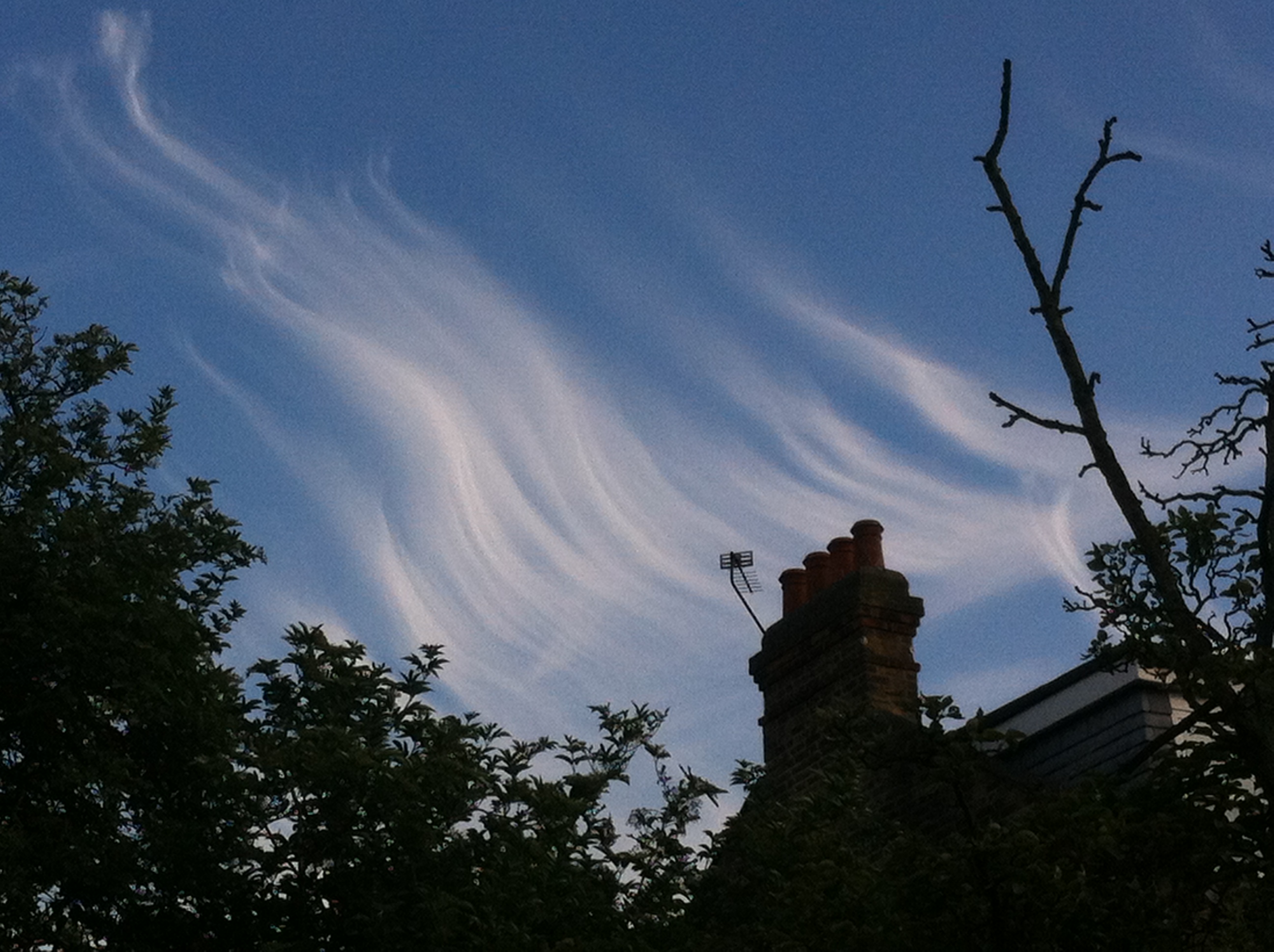
Yet another occasion of impressive cloud formation during June included this example of late evening cirrus. The formation, seen at ground level, seemed similar to a display of the AuroraCircumhorizontal arc over Aldersbrook


You must be logged in to post a comment.