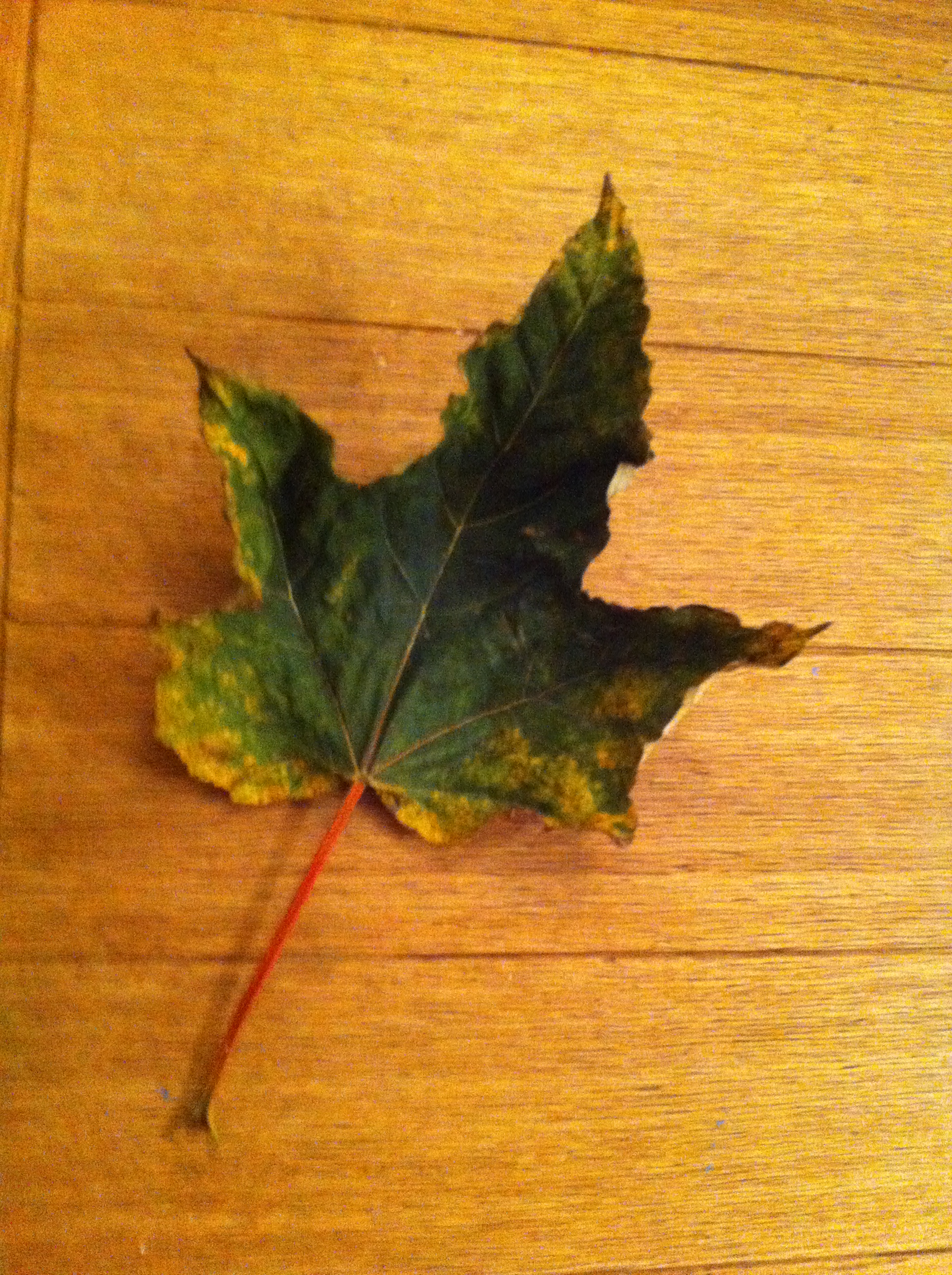
While heavy low cloud obscured the partial eclipse in this area there were a couple of interesting factors that I observed.
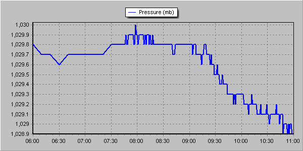
At 9.45am, shortly after the maximum obscuration of the solar disc the air pressure suddenly dropped. This coincided with sudden relief to my blocked nasal passages, symptoms of which appeared last night. Eighteen minutes later the fall in air pressure became less steep and the nasal symptoms returned.
The pressure dropped from 1029.8mb at 9.15am to 1029mb at 10.15am. I’m not sure if it was an effect of the eclipse or just a change in the synoptic situation that would have happened anyway
As the light began to fade it seemed to turn colder though, on looking at the actual figures, the effect of the partial eclipse through heavy cloud was a depression in temperature of 0.3C. I worked this out by comparing today with yesterday which had almost identical weather conditions. People remarked that it turned noticeably colder though perhaps this was more caused by standing out in temperatures of 4.9C for a long period.
Like the eclipse in 1999 I noticed that the birdsong quietened somewhat though there was not the same crescendo of noise that you normally get at dusk when birds roost.
Here is the temperature trace from the 19th. Even with the heavy cloud yesterday there was more warming from the sun, albeit by a very small 0.3CThis graph shows the temperature from 6am until 11am. Though the depression during the eclipse was just 0.1C comparison with the previous day, which saw near identical weather conditions, shows just how much solar heating was depressed
This winter was the second sunniest on record in this region. Sunshine hours totalled 238 hours during December, January and February – that’s 142% of average and second only to 2007/08.
Winter 2014/15 was the second sunniest on record with 238 hours of sunshine
The first lying snow for two years is also a notable observation of winter 2014/15. That it lasted just a few hours emphasises how little snow there was at sea-level for the second winter in succession.
The mean temperature of 5.2C was just 0.3C below the 1981-2010 average. Some 152mm of rain fell – that’s just 7mm over the winter average.
Winter began with the sunniest December on record in my series going back to 1877. Over 90 hours of sunshine was recorded in this area which is 224% of what we can expect to see during an average December.
January saw the first falling snow in nearly two years with the last three days of the month seeing the first flakes of winter – nothing much to write home about by average winter standards.
February produced the first lying snow in nearly two years. The 1cm depth at 9am on 3rd, however, is nothing much to write home about by average winter standards.
The wettest day during the three months was January 12th when 13.1mm fell.
Snow fell on 6 days. Air frosts: 27 Ground frosts: 48
Full stats for winter can be found here: http://1drv.ms/1rSfT7Y
At the end of November I published my annual winter forecast. I said the season would *probably* be colder with a better chance of snow than last winter. If I’m honest I thought we’d see more incidents of snowfall though, with my predicted mean temperature of 4.2C being exceeded by 1C, the air around the UK just wasn’t cold enough for snow at sea level. My predicted rainfall was more impressive – I forecast 156mm and was out by just 4mm!
Obviously when the season is average long-range forecasts like this have a much higher chance of being correct. One could argue that basic climatology has made my forecast look a reasonable one. But I stick to what the stats suggest and try to steer clear of the endless hyperbole published almost daily by certain tabloids.
A snowfall on the 3rd just about covered the ground for a few hours, though was barely enough to make a snowball
Though it only lasted a couple of hours this February saw the first lying snow in nearly two years. The 1cm depth at 9am on 3rd, however, is nothing much to write home about by average winter standards.
Mean temperature for the month was 4.9C, 0.4C below the 1981-2010 mean, 2.5C cooler than the mild and stormy February of last year. Rainfall of 43.6mm was 111% of average.
There were 73.6 hours of sunshine recorded in this area which is precisely 100% of what we can expect to see during an average February. The wettest day occurred on the 19th with 8.7mm. Snow fell on 3 days, hail on 2. Air frosts: 4 Ground frosts: 19
So what has March got in store weatherwise? The models this morning (March 1st) suggest a taste of spring – the recent cold and showery regime being replaced by quiet, anticyclonic weather. Output suggests variable cloud cover with a mild SW wind. Obviously sunny days will see quite respectable temperatures though any clear nights will see frost and mist developing.
View from top of Ditchling Beacon in Sussex during a half-term walk
Beyond that the outlook is uncertain. Using a similar method to my Christmas forecast, which was correct at 25 days ahead and my January and February outlooks, I’ve had a look back in the archives to see if there is any precedent in the pattern we’ve had this February.
There appears no chance of a very mild March. The strongest signal (67%) is for a cold March. The strongest signal for precipitation is for average to slightly below (83%). Sunshine, no overall signal, so my guess is average.
Though we are now out of the meteorological winter there is still a risk of snow. Any falls, however, would be thin and transitory because of the strength of the sun now.
1st Bright start with sunny spells thoughout the day
2nd Sunny start but soon clouded over. Cleared again in evening though with lunar halo. Showers moved in after midnight and into early hours to leave thin coating of snow by 8am.
3rd 1cm at 9am. A bright start though with lots of cloud around. Sunnier in afternoon, the snow had melted by 1pm. Variable clear spells through the night but too cloudy for frost.
4th Cloudy start but some brightness. The sunshine felt warm at times. Variiable cloud overnight. Woke up to see snow falling but too warm to settle – the air being 1.2C, dew point 0.5C
5th Some spots of sleet to start and during the day. Colder air digging in from 3pm. Feeling bitter.
6th Bright start, cloud decreasing through the day to give long sunny spells. Cold wind
7th Cloudy and cold start
8th A sunny start with long sunny spells all day
9th Mostly cloudy to start though bright and breaking to sunny spells and then unbroken sunshine.
10th Cloudy and cold all day
11th Dull and cloudy all day
12th Dull start and stayed dull all day. Cold. Warming up after 2am with some very light rain with warm front.
13th Bright spells through the morning with a brief clearance around 1pm. Rain soon arrived though and fell through the afternoon and into the evening. Rain again from midnight until 2am
14th Bright intervals to start though mostly cloudy through the day. Some very light rain showers through the day and into the night
15th Cloudy start though with bright intervals becoming more frequent. Clear by dusk allowing temp to fall quickly
16th Cloudy start with rain spreading in after 1pm, moderate at times
17th Unbroken sunshine until 1pm then a few clouds. Cold overnight on boat
18th Sunny most of the day with only a few high clouds
19th Sunny until mid morning then clouding over quickly. Rain pushed in late lunchtime and lingered all day and into evening. Stayed dry on walk until 2.30pm but very stong wind ahead of rain band
20th Cloudy start though bright through haze at times. Feeling cold. Cloudy into evening with area of rain at 7am
21st Sunny start after rain at 7am. Very cloudy at times with light hail <5mm – the sky suggested the hail was heavy elsewhere. Reports of snow in Oxford. Frosty overnight
22nd Sunny start but cloud quickly filled in before rain arrived at 3pm. Temp then rose to a high of 9.5C at 11pm before falling at midnight
23rd Sunny start but with cloud bubbled up and some light hail mixed in with showers. Feeling cold
24th Sunny start with some cloud bubbling up. Heavy hail shower at 3.30pm. Temp built through the night with rain 5.30am – 7.30am
25th Drizzly start broke to sunny spells. Much milder. Drizzle overnight after 3.30am
26th Cloudy start with rain late morning. Cold front blew through around 2pm. Clear and frosty overnight
27th Sunny, cold start. Cloud gradually increased through the day. Temperature lifted a little – spits and spots of rain felt on way home
Signals for winter have always been well reported by the media. Back in the 1980s weather anoraks across Britain would wait with bated breath to read Bill Foggitt‘s latest prognostications for the coming winter. Though Foggitt had some success his observations, among other weather ‘gurus’, often amounted to weatherlore that has only a slightly greater than evens chance of being right.
One popular myth is that very large blackberries mean a harsh winter. The fact that this has more to do with plentiful rainfall plumping up the fruit at harvest time is ignored.
Colin Finch’s 38F minus rule is altogether different and provides a very good guide to the kind of weather we can expect in January and February. For the rule to work the maximum temperature must be 38F (3.3C) or less for four consecutive days before Christmas Day.
Colin, an amateur meteorologist who passed away in 1991, spent much time researching his rule in the 1970s. He found that most of the coldest winters since the end of the second world war gave a hint of things to come in the weeks leading up to Christmas: the Decembers of 1946, 1955, 1962, 1968, 1969, 1978 were all followed by cold late winters. In 1984 and 1985 the cold spell arrived at Christmas. Other years to loosely follow the rule, 1986, and 1990.
A few weeks ago I was reminded about Colin’s findings and decided to have another look, using daily record data for this area stretching back to 1806.
The results were surprising. If there is a run of cold days (3.3C or less) around mid-month the chance of an average to colder than average January and February is 94% and 74% respectively. The chance of an average to colder than average March is 96%. Also notable is that the chance of a severe spell in January (4C colder than normal) is 30%.
So much for the figures. What are the chances of a run of cold days between now and Christmas Day?
Sunset Southwark Bridge
Up until this week the weather has been fairly quiet with little rain and cold, often frosty nights. But westerlies are now roaring back in from the Atlantic and could be a hint of what is likely to prevail later in the winter. However, the ‘crunch’ time for the 38F minus rule comes soon after the middle of the month. If a spell of Arctic weather develops at that time, even if it lasts only a few days, then the chances of a major cold spell after Christmas are much higher.
As I write this blog the models suggest that a run of cold days may just be possible. It is also notable that the likelihood of a sudden stratospheric warming event, argued by many to be a precursor for conditions that would favour the development of a cold spell, is increasing with a peak set for mid January.
We’ll see but Colin Finch’s findings all those years ago are fascinating and are still relevant today.
* The following obituary appeared in an edition of Weather magazine, a publication of the Royal Meteorological Society, in 1991.
“Colin Finch – The news of the sudden death of Colin Finch on Friday, 23 August 1991 at the tragically early age of 55 will be received with sadness by Members of the society and readers of Weather.
There is no doubt that Colin was one of the most enthusiastic amateur meteorologists that the Society has ever had and, without seeking publicity for himself, he was responsible for making many other amateur enthusiasts aware of the Society and encouraging them to join.
Colin’s interest in the weather began when he was a small boy and received a considerable boost during the snowy and very cold winter of 1946/47 when he was 10 years old. In 1949, at the age of 13, he began to take regular temperature and rainfall readings and gradually added more sophisticated equipment. His record of daily weather data was unbroken until July 1991 when he became too ill to continue.
When he left school in 1953 he joined the Meteorological Office as a Scientific Assistant at Kingsway and was trained under the keen eye of Dick Ogden. Later, after a spell at Heathrow Airport, he left the Office frustrated by his inability to develop a career because he didn’t have sufficiently good educational qualifications. Instead, he turned to a successful business career but his enthusiasm for weather observing and forecasting increased.
Each day he plotted and analysed synoptic charts compiled from short-wave Morse code transmissions which he took down by hand. In the 1960s and 1970s it was quite normal for him to spend Saturdays plotting a chart for the whole of the Northern Hemisphere from Morse broadcasts. Later he had facsimile and satellite-receiving equipment installed at home.
By the late 1960s he was liaising with local authorities and the police in Surrey, warning them of the likelihood of severe weather events. In 1970 he joined the then newly introduced BBC Radio London and every Friday morning he would discuss current weather events and give climatological background data about the week ahead. For these broadcasts he would get up in the early hours to plot a synoptic chart before he went to the studio.
After the broadcasts he would go to the City for a normal day’s work. He kept up this punishing schedule for several years. When the Society introduced the highly successful one-day Saturday discussion meetings in September 1972 Colin was one of the first amateur meteorologists to give a presentation and he was a regular contributor to these occasions. He was an imposing figure, 6ft 4in tall, and was easy to seek out at meetings.”
The final month of autumn was most notable for its rainfall with 19 consecutive days of measurable precipitation and just four completely dry days .
November 22nd by Perch Pond. Drizzle early morning couple with damp air left mist floating above the surface
The month was warmer than average; the mean temperature of 8.9C was 0.9C above average, making it the 19th warmest November since 1797: 2.2C warmer than last November, though only the warmest since 2011.
The sunny and start on the 1st was quickly replaced with an unsettled, cooler regime week which lasted for nearly three weeks. A brief respite on the 20th was followed by more rain – with 12mm and 15.2mm on the 22nd and 23rd. It was wetter than average: 97.5mm represents 165 per cent of what we’d expect to fall in a normal November.
Despite it being wet it was only the 40th wettest November in the series back to 1797.
The warmest day occurred on the 1st with 17.2C recorded. The first frosts of autumn were recorded. The lowest temperature occurred on 24th when the mercury fell to -1.5C.
Sunshine was average with 60.5 hours recorded – that’s 103 per cent of mean. The sunniest day was on the 4th when 6 hours of sunshine were recorded.
Over the next couple of weeks speculation on Christmas Day weather will inevitably build. Will Christmas be white or green?
Shoulder of Mutton pond, Wanstead Park
At this range it is impossible to tell from standard meteorological models though from the 15th, 10 days before the big day and when models can start to be relied upon for at least a general trend, the pieces of the weather jigsaw will start to fall into place.
Latest odds offered by bookies William Hill for a single snowflake at London Heathrow are currently 8-1, slightly longer than I’d expect at this time of year. With high pressure building and a general cooling trend this week I’d expect those odds to start to come down.
In terms of proper snow falling and settling, there has not been a white Christmas in Wanstead for over 30 years. In 2010, we could still see the Christmas card Victorian snow scene in small patches if our gardens, but these were leftovers of a previous dump, so it doesn’t count. Frustratingly, there has been snow on several Boxing Days in Wanstead (1995 and 1996) and in the weeks running up to Christmas, but not on Christmas day itself. The most typical Wanstead Christmas day weather is mild and dry, although it has rained on 12 of the last 33 Christmas days.
The period just before Christmas last year was very stormy
In an earlier blog I had a look at what the last 170 or so Christmas Days in London were like weatherwise and found that snow actually falling on the day is extremely rare. Since 1840 there have been just 19 occasions of snow or sleet falling on the capital on Christmas Day which equates to a probability of just under 11%. If you consider that the last ‘white Christmas’ (see note) was in 1996, then we are well overdue one.
But the weather doesn’t adhere to human created calendars and behave like it should on any given day. But patterns in any given year can sometimes repeat though correctly predicting they will happen is more down to luck. Nevertheless I’ve had another look at my calculations for this winter and see if there is any way I can make a prediction for Christmas Day.
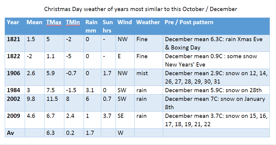
I firstly had a look at Christmas Day stats overall since 1840. The most common group of maxima in the series is 8.1C and above. This occurred 69 times or 40%. I then had a look at the years that most closely follow this October and November. None of the years saw a white Christmas, however it is interesting to note that five out of the six years saw some snow during the month. Snow often falls before and after Christmas. Why that is no-one knows.
So my guess for the weather on Christmas Day this year is for a maximum temperature of 6C after an overnight low of around 0C. With a little rain likely I suppose there is a chance of at least something sleety falling though I’d be surprised if, on Christmas Day morning, we pull back the curtains on a wintry Dickensian scene.
* The definition of a white Christmas used most widely – notably by the bookies – is for a single snowflake, even if it lands in the midst of heavy rain, to be observed falling in the 24 hours of 25 December at a specified location recognised by the Met Office.
** On average, snow or sleet falls in the UK 5 days in December, compared with 7.6 days in January, 6.8 days in February and 6 days in March. White Christmases were more frequent in the 18th and 19th centuries, even more so before the change of calendar in 1752, which effectively brought Christmas back by 12 days. Climate change has also brought higher average temperatures over land and sea and this generally reduces the chances of a white Christmas.
Christmas in Victorian London is often portrayed as very cold and snowy – picture perfect images of Yuletides past always scream out at us every year we open a box of Christmas cards.
The Temple, Wanstead Park, always looks that much more stunning with a covering of snow
But a look back through the meteorological records of the Royal Observatory at Greenwich reveals a very different reality.
The 1840s and 1850s, decades where most Christmas traditions marked today began, were often very mild, wet and windy – indeed before 2015 the warmest Christmas Day maximum temperature at Greenwich occurred in 1852 when the mercury reached 13.3C.
Like modern times, however, there were exceptions and 1840 was very cold – the record for Christmas Day mentions “trees coated with rime (ice) 3/8 inch thick”!
The following 20 years saw Christmas morning much milder – well over half had maxima of 6C or higher. In 1843, the year Charles Dickens first published A Christmas Carol and the public sent their first Christmas cards, the temperature reached a balmy 10.1C – though dense fog probably made it feel at least a bit more seasonal.
Frost is a common feature of Christmas Day
Four years later in 1847, the year the capital’s Tom Smith invented the Christmas cracker, things were a bit colder – a high of 4.2C and overcast with rain late evening. The following year an image of Victoria and Albert celebrating with their family around a Christmas tree appeared in the Illustrated London News. Like many things Royal down the years it really captured the public’s imagination of taking a spruce or similar evergreen into their living rooms and decorating it every Yuletide.
Christmas two years later, in 1849, was at least cold enough for something wintry to fall. London, however, was still coming to terms with its worst-ever cholera outbreak. With around 14,000 deaths from the disease Christmas was probably not a high priority that winter.
When Good King Wenceslas was first included in Carols for Christmas-Tide in 1853 the day was cold but there was still no “deep, crisp and even” snow or “rude wind’s wild lament”. The day stayed calm and clear.
Though the period either side of December 25th began to be marked with cold, snowy spells it would be another 11 years before London experienced its first official white Christmas in 1864. Sleet, which fell at the end of a 4-day cold spell, probably added to the drama of swimmers taking part in the first Christmas Day swim in the Serpentine, Hyde Park. With a high temperature of just 1.4C it’s quite feasible the few who braved it probably had to break the ice before they took the plunge.
Five years later London experienced another white Christmas with snow falling in a north-easterly breeze – the start of a four-day cold spell.
The joint-coldest Christmas Day on record followed in 1870 with a mean temperature of -7.2C. The building of the Royal Albert Hall was scheduled to be completed by December 25th but it was not until March 29th 1871 that it was officially opened by Queen Victoria.
The remainder of Victoria’s reign was marked with far more white Christmases, a period where nearly two-thirds of Decembers were marked with extended cold, snowy spells. Fog and frost were also frequent.
With a new century and new monarch Christmas-time turned milder and London would have to wait until close to the end of Edward VII’s reign in 1909 to see a ‘white Christmas’ – a poor affair with just a bit a sleet mixed in with the rain late morning. Many probably failed to notice it but it still counts as a white Christmas according to modern bookie’s standards.
Christmas Day can also be stormy
Four of the 26 Christmas Days of George V’s reign were white but the mean temperatures suggest they were all marginal affairs – the core cold weather happening either before or after the 25th. Of note also is the dominance of south-westerlies that brought mild and wet weather – nine out of ten Christmas Days in the 1920s saw rain falling – far in excess of the average for rain on Christmas Day which is 47 per cent.
Just one Christmas was white during George VI’s reign, a ‘good covering of snow’ was recorded by observers at Greenwich in 1938 – the snow falling at the end of a 7-day cold spell.
Sunshine was not a dominant feature of Christmas Day prior to Queen Elizabeth II coming to the throne – the average total in Greenwich from 1877 to 1951 was just under 0.8hrs. Yet the average sunshine total for Christmas Day for the first four years of Elizabeth’s reign jumped to 5.2 hours. The 6.5 hours on Christmas Day 1952 is a record that still stands today! It is remarkable that this record was set just over a fortnight after the Great Smog contributed to the deaths of 4,000 people though other studies put the figure at 12,000 people.
The Clean Air Act 1956 ironically saw the return of dull Christmas Days – though 1956 was a white Christmas with a light covering of snow and a maximum of zero Celsius.
White Christmas Days that followed included 1957 (showery sleet), 1964, 1968 (sleet), and 1970.
Christmas Day 1976 was the last time snow actually fell on Christmas Day in this area though, officially, the last white Christmas was 1996 when a few sleety flakes fell in the early morning.
Christmas Days since then have been mostly mild affairs in London. Of course we had a taste of what a Dickensian Christmas Day was like four years ago when the mean temperature for the day was -1.9C. There were still small patches of snow in our gardens but these were leftovers from a previous dump, so it doesn’t count as a white Christmas. Frustratingly, there has been snow on several Boxing Days in Wanstead (1995 and 1996) and in the weeks running up to Christmas, but not on Christmas day itself.
The warmest Christmas Day in this area occurred in 2015 when a maximum of 15.2C was recorded. Warm air sourced from off the west coast of Africa sent dew points soaring, the minimum on Christmas Day night into Boxing Day did not fall below 13.5C, another record.
The synoptic chart for 0000z Christmas Day 2015 shows ever-warmer air being pumped northwards over the British Isles.
It is surprising how varied the weather can be on Christmas Day – we always think that Yuletide in the ‘Olden Days’ was a cold affair but a look back to 1840 reveals there were times when it was just as mild as it has been in recent years.
Christmas Day morning 1927: the wettest with some 24.9mm recorded
* Statistics for every Christmas Day since 1840 can be found here.
** The definition of a white Christmas used most widely – notably by the bookies – is for a single snowflake, even if it lands in the midst of heavy rain, to be observed falling in the 24 hours of 25 December at a specified location recognised by the Met Office.
*** In the past 170-odd years there has only been 19 white Christmases: in 1864 (sleet), 1869, 1876, 1878, 1884, 1895, 1909 (sleet), 1916, 1919, 1925, 1927, 1938, 1956, 1957 (sleet), 1964, 1968 (sleet), 1970, 1976, 1996 (sleet)
Save for the warmest Hallowe’en on record and a notable depression on the 21st October was a relatively quiet month.
The month was warmer than average; the mean temperature of 13.7C was 1.9C above average, making it the 5th warmest October since 1797: 0.7C warmer than last October, though only the warmest since 2011.
The dry and sunny start was replaced with a very unsettled regime at the end of the first week which lasted until the end of the second week – with 39.5mm of rain falling over the 12th and 13th, a notable total for this region. It was wetter than average: 82.4mm represents 123 per cent of what we’d expect to fall in a normal October.
Despite it being wet it was only the 74th wettest October in the series back to 1797.
The warmest day occurred on the 31st with 21.5C recorded. Many nights were warm with date records matched or broken. Cold nights, relative to the time of year were few. The lowest temperature occurred on 4th when the mercury fell to 2C – a ground frost was narrowly avoided with the grass minimum thermometer falling to 0.2C.
Sunshine was slightly below average with 103.6 hours recorded – that’s 97 per cent of mean. The sunniest day was on the 5th when 9 hours of sunshine were recorded.
Anyone hoping for a continuation of June and July’s hot weather would have been left sorely disappointed by last month which was characterised by frequent rain and the coldest August night for over 20 years.
A stunning example of sunlight illuminating the underside of cloud at sunset was seen mid-month
August 2014 was the first month this year to be cooler than average; the mean temperature of 17.2C was 1C below average, making it the 89th warmest August since 1797: 1.6C cooler than last August, the coolest for 7 years.
The month was marked with thunderstorms and heavy downpours, contributing to what was a much wetter than average month – some 76mm fell which is 152% of the monthly average and the wettest for 4 years.
The hottest day occurred on the 7th with 27.3C recorded – nothing special for August and a date that heralded the end of the hot spell during June and July.
A couple of nights were notably cool for August: 5C was recorded during the early hours of the 23rd – the coldest August night since 1993.
Sunshine was below average with 161 hours recorded – that’s 83 per cent of mean. The sunniest day was on the 3rd when 12 hours of sunshine were recorded. Throughout the month there were just 2 days with 10 hours or more of sunshine. There were 4 days with thunder recorded – the average for August is 3.
Looking further afield there were many thunderstorms around the UK though many places missed out on the big downpours. It was yet another month where rainfall totals could vary greatly in the space of just a few miles.
On the 9th a station in Woodford Green recorded 24.4mm, double what fell in Wanstead. The legacy of TS Bertha coincided with the end of our extended hot spell – an excellent analysis of this storm can be found here.
There were some spectacular cloud formations not far from here. A particularly good one was seen in Witham.
On 25th a perfect curl could be seen on a depression centred off the west coast of Irleland. The rain associated with this low pressure brought the month’s highest daily rainfall total: 23.4mm (the system bringing 27.5mm) – a thoroughly miserable Bank Holiday Monday where it rained ALL day, from 6am until 9.30pm. It was yet another example of how much even frontal rainfall can vary over a small area.
On 25th a perfect curl could be seen on a depression centred off the west coast of Irleland. The rain associated with this low pressure brought the month’s highest daily rainfall total: 23.4mm (the system bringing 27.5mm) – a thoroughly miserable Bank Holiday Monday where it rained ALL day, from 6am until 9.30pm. It was yet another example of how much even frontal rainfall can vary over a small area with St James Park recording 38.2mm. The top 30 totals for that day can be seen here.
sunset overlooking Wanstead Flats 2nd August
Looking even further afield four people were killed in a flash flood at an Italian festival early on in the month.
July 2014 was yet another milder than normal month; the mean temperature of 20.2C was 1.7C above average, making it the 9th warmest July since 1797 – and 0.5C cooler than last July.
The month was marked with spectacular thunderstorms and torrential downpours, contributing to what was a much wetter than average month – some 73mm fell which is 168% of the monthly average. While on paper the month looks very wet it should be noted that 52% of the July total fell in two episodes: a stalling warm front on the 10th and a cloudburst on 25th. I was away for the thunderstorm though a friend remarked that the roads close to Redbridge Roundabout were like torrents, the rain was so intense for a short period. I’ve put together a series of radar images that show the evolution of the storm, together with graphs, that can be accessed here.
The hottest day was July 18th with 32.7C recorded. There were 12 occasions where the mercury reached or exceeded 80F – pretty respectable though last July saw that figure reached on 20 days!
The sunniest day was on the 3rd when 15 hours of sunshine were recorded. Throughout the month there were 11 days with 10 hours or more of sunshine. There were also 5 days with thunder recorded – the average for July is 3.
Looking further afield there were many thunderstorms around the UK though many places missed out on the big downpours. Perhaps the most impressive was the development of the MCS that moved up from France during the evening of July 18th. There were numerous superb pictures but my favourite is probably this shot taken by Richard Dixon in Whitstable, Kent. It shows, perfectly, the contrast betweeen the bright orange sunset and the impending doom of the approaching MCS from the continent.
This shot was taken by Richard Dixon in Whitstable, Kent. It shows, perfectly, the contrast betweeen the bright orange sunset and the impending doom of the approaching MCS from the continent
A thunderstorm on Sunday, July 20th, saw three inches of rain fall on Canvey Island in a very short space of time. A good round up of events, including pictures, can be seen here. The thunderstorm on 25th was felt across London and the Home Counties – there’s an excellent picture of the approaching shelf cloud here. Brighton was rudely awoken by a storm on 28th by a slow-moving thunderstorm.
It is a typical feature of summer that rainfall can vary a great deal across a small area. The nearest official station to Wanstead, St James’s Park 8.4 miles to our south-west, recorded recorded just 25.9mm – 35% of what fell here.
The nights were mostly warm – the 14.8C average is higher than last July.
Overall July was a superb summer month – sunshine, heat, thunderstorms in abundance.
Sunset on 31st looking across Wanstead Flats. July was a classic summer month for weather


You must be logged in to post a comment.