Weather models are continuing to struggle in the aftermath of the stratospheric sudden warming on January 1st. The GFS and ECMWF have flip-flopped: on one run decent northern blocking extends southward only for the dreaded European high to appear on the next.
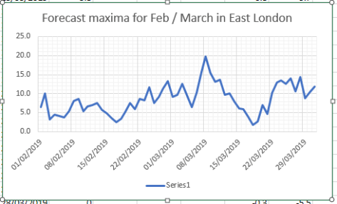
Using a combination of QBO and ENSO data featured in my winter forecast and statistics from previous SSWs (including 2013 and 2018) achieved the following results shown in this graphic.

Although some days in the next week or so will be cold it is not until the 14th that conditions start to bite, the start of a week-long cold spell that will probably be more notable for cold than snowfall.
The rapid recovery in temperature would suggest that the Azores / European high making a return. With the MJO moving back and forth between phase 7 and 8, and looking at the behaviour of previous cold spells, this would make sense.

As for February, unless there are further SSWs to disrupt the polar vortex, and depending on its recovery, it is unlikely we will see a repeat of the winter of 1984/85 that I hinted at last month. The graphic below, however, would suggest another cold spell in the third week of February.