Tag Archives: Wanstead Flats

January 2016: average and wet

The coldest night in three years was recorded last month together with the first lying snow in January since 2013 – though you had to be up early on Sunday 17th to see it.

epping snow
Snowfall on the 17th was just over 1cm deep at High Beech. In Wanstead it was just a thin covering that was gone by midday

For anyone looking for ‘traditional’ winter weather it was pretty desperate stuff and seems a continuation of the mild winters of the past three years.

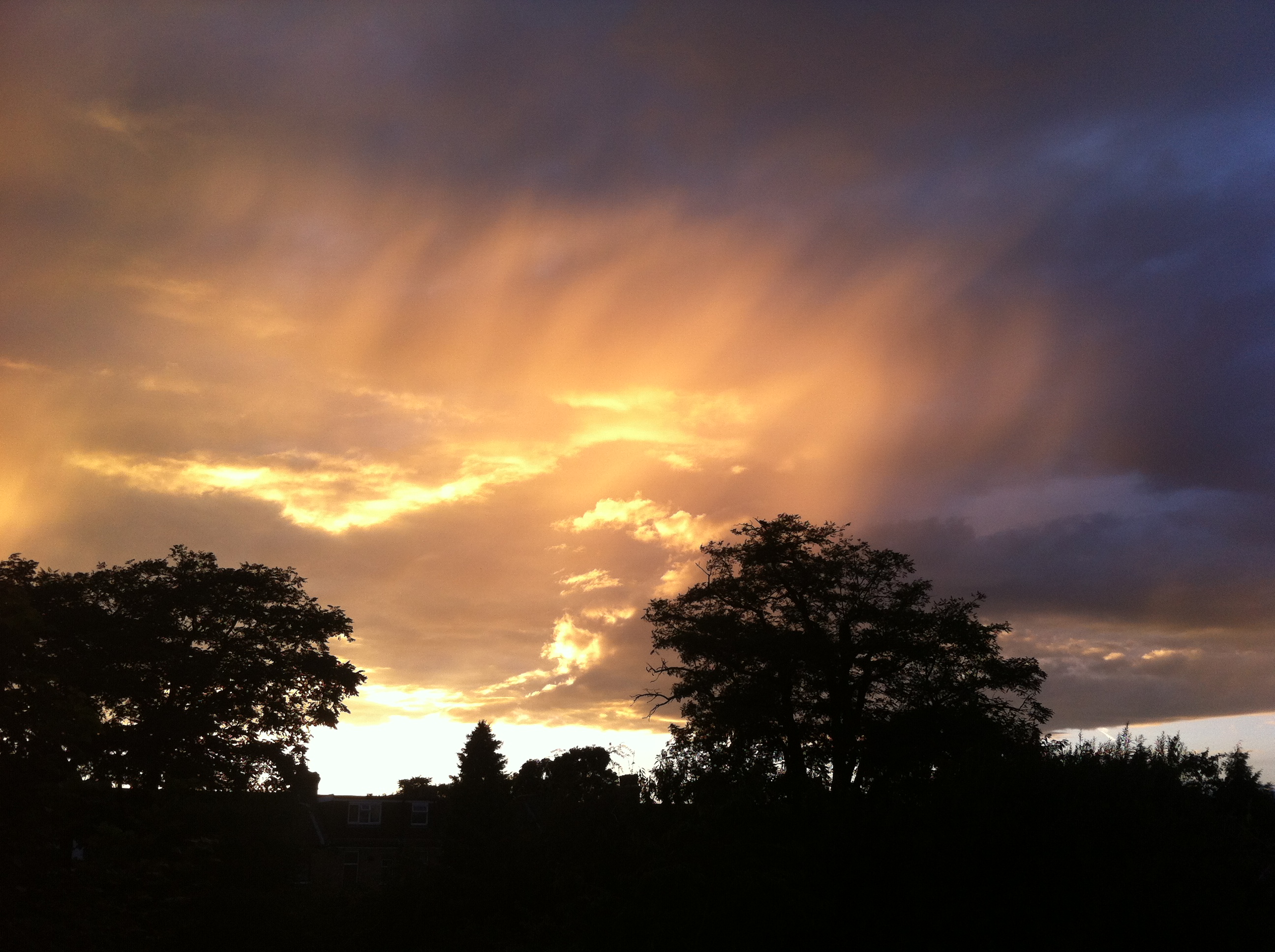
Apart from a mild final week much of the month was rather cold with a couple of sharp night frosts that affected many early daffodils that bloomed during the super mild December.

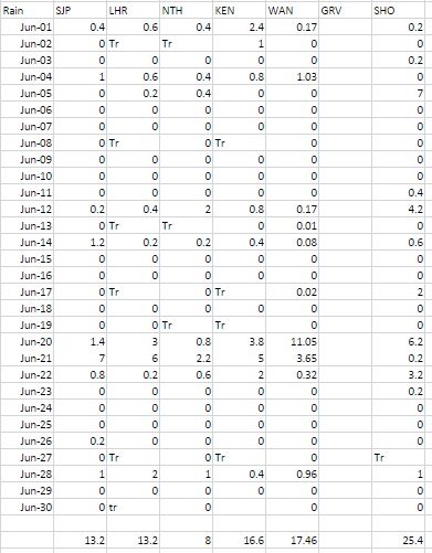
Rainfall of 65.8mm was 124% of average – very similar to last January’s total. Mean temperature for the month was 5.8C, 0.6C above the 1981-2010 mean. It felt far cooler, however, because the December mean was 5C above average.

high beechSunshine was just above average. Over 54 hours were recorded, 108% of what we can expect to see during an average January.

The wettest day occurred on the 10th with 11.6mm.

Air frosts: 6

Ground frosts: 18

So what has February got in store weatherwise? There is no sign of any longer term changes in the pattern of synoptics across the UK. All models continue to suggest a very volatile jet stream with resultant low pressure close to or across the UK for much of the first half of February.

new street
The snow on the 17th fell during the early hours of the morning

This week westerly winds will remain strong with severe gales in the north in association with Storm Henry over the next 36 hours. The current mild and damp conditions in the south should be replaced with colder, showery air moving south later on Monday, lasting into Wednesday. On Thursday another large warm sector will move up across the UK from the SW returning mild and damp conditions.

At the weekend all models show low pressure areas taking a much more southerly route across the UK with gales and wet weather. While no cold weather looks likely there may be incidences of very heavy and thundery showers. Only GFS on Monday is showing any hint of more settled, colder weather at the end of the period.

Using my long range method February is looking average, very dry and dull.

A mean of about 5.9C, just over average, is the highest probability at 71%. Something ‘rather mild’ comes in at 29% probability.

Rainfall is looking low: 15mm represents something 38% of average.

Sunshine totals will be low and it could be a dull month, around 60 hours of sunshine, that’s just 82% of average.

My January outlook for temperature good. I predicted a mean of 5.2C (outcome: 5.8C) with 59mm of rain (outcome: 65.8mm).

Here follows the full weather diary for December. To view full stats follow this link:http://1drv.ms/1kiTuzv


1st: Bright after sunny, clear dawn before clouding over with light rain. Rain at midnight.
2nd: Cloudy start after early overnight rain. Rainy spells and blustery throughout the day.
3rd: Drizzle to start then damp before more rain moved in at 11.30am – this fell intermittently through the day and evening and was often heavy.
4th: Bright, damp start after overnight rain. Some light outbreaks up to 2pm.
5th: Sunny, clear and cold start with contrails dotting the sky. Clouding over later with rain after 6pm. Misty around midnight.
6th: Bright, very damp start. Mostly cloudy with rain in the evening and overnight.
7th: Dull start with outbreaks of rain spreading in, some heavy and very blustery. Drying up after lunchtime though feeling cold. Cool overnight with frost on cars with a very brief shower on school run.
8th: Bright start though light showers around. Gradually clouding over. Clearer spells overnight and cool.
9th: Bright start though with plenty of cloud around. Showers, some heavy with small hail at 8.30pm. Clear spells overnight.
10th: Bright start after overnight rain. Cloud gradually decreasing to leave it clear at noon. Cloud returned after dusk and thickened up around 9pm. Heavy rain from midnight.
11th: Cloudy, damp and cold start. Some breaks after noon then clear spells overnight and cold.
12th: Sunny, cold start. Clouding over at midday to leave cold-feeling afternoon and overnight – too much wind for a frost.
13th: Bright, cold start but turning mostly cloudy. Rain in the evening and on ride home.
14th: Rainy. cold start, then cloudy with sunny intervals. Cold air digging in from midday.
15th: Sunny all day with just a few cirrus. Took a while for frost to form properly.
16th: Sunny, frosty start with just a few cirrus. Variable cloud and evening in London felt freezing. Some drizzle, this turned heavier and by 4am thick flakes were falling to give a thin covering. Some 1cm at High Beach during a bike ride.
17th: Cloudy start. Thin covering of snow (<1cm) thawed by lunchtime. Cloud built into afternoon to leave chilly evening.
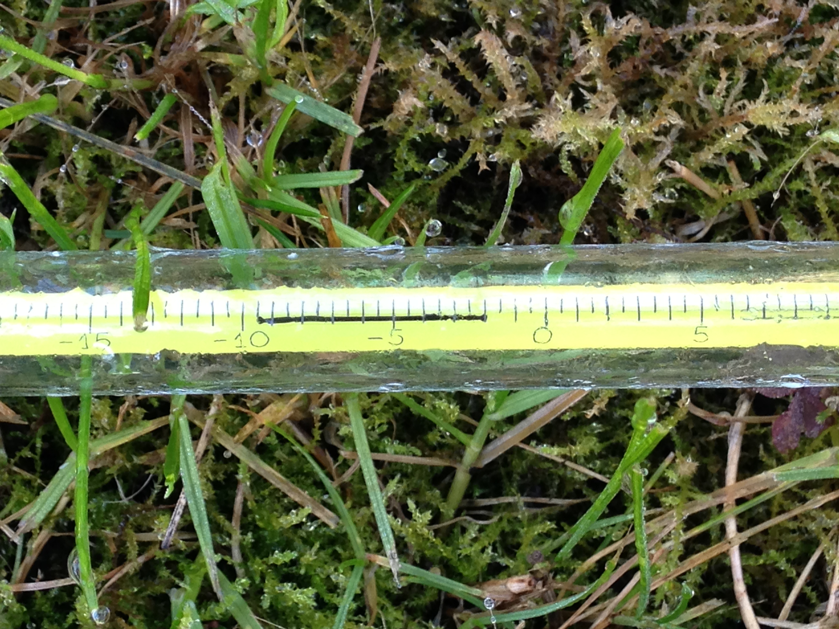
18th: Bright start but sunshine was weak so felt cold. Mostly clear into the evening allowed for an early frost. A classic radiative cooling night until the early hours, assisted by a very gentle low-level flow off the continent where there were some very low dew points. Between 2am and 6am there was some thin, high-level cloud that drifted across, which stopped the radiative cooling. Warmth from the ground then briefly lifted the temperature until, once more the cloud cleared after 6am and allowed the temperature to fall again to its minimum of -5C at 0809z. There was also a little mixing of the layers of air between 2 and 6 which would also have had a cooling effect. Had it not been for the cloud I’d suggest that the low could have fallen to -6.2C, which would have been the coldest since February 2012 when it fell to -9.2C over full snow cover.
19th: Sunny all day with occasional alto-cumulus drifting across. Another cold night, the coldest in 3 years.
20th: Bright start with lots of scattered cumulus. Sunnier early afternoon and less cold. Another frost quickly forming after dark.
21st: Frost lifting quickly then cloudy with limited brightness throughout the day.
22nd: Cloudy start with rain arriving at 9.05am. Bursts through the day until early afternoon. Some brief brightness in the late afternoon.
23rd: Sunny, cool start. Clouding over with rain in the evening. Very mild.
24th: Cloudy start after overnight rain. Mostly cloudy with odd spot of drizzle though bright.
25th: Sunny, clear start though cloud bubbled up at 11am to leave mostly cloudy afternoon. Clear spells overnight and chilly.
26th: Cloudy and increasingly gusty up to midday. Some rain in the evening.
27th: Cloudy, blustery start.
28th: Sunny all day with just a few clouds around noon.
29th: Cloudy and breezy with some drizzle in the wind early afternoon. Report of 101mph gust on Shetland from Storm Gertrude. Wind seemed to strengthen at midnight before rain arrived.
30th: Cloudy and damp start after overnight rain. Sky soon cleared to leave mostly sunny afternoon.
31st: Drizzle in morning as warm front moved in.

Wanstead weather: 2015 review

This year finished as the ninth warmest year on record – some 0.5C cooler than 2014.monthly anomalies

Every month of 2015, apart from September, November and December, was roughly average – the means being within +/-0.7 every month, bringing the mean temperature to 11.9C, 0.7C above the 1981-2010 average.

Rainfall was less remarkable with the year being dryer than average. The total of 553mm puts it as the 162nd wettest since 1797.

It was also a very slightly duller than average year with 1,433 hours of sunshine recorded. That’s 97 per cent of average, the 77th dullest since 1881 – the least amount of sunshine for 11 years.

weather stats for 2015

For a review of each month, click January, February, March, April, May, June, July, August, September, October, November, December.

To view full stats follow this link:http://1drv.ms/1kiTuzv


November 2015: Very mild and dull

The final month of autumn was most notable for its warmth and lack of sunshine.

14112015 rain
Rainy days were common through November. This system brought 5.6mm 

The November mean was 10.5C, the third warmest on record back to 1797. Only 2011 and 1994 were warmer.

Just 31.7 hours of sunshine were recorded in this area: 54% of average, the dullest November for 47 years, and 9th dullest in the series going back to 1881

Rainfall was more run-of-the-mill: 64.3mm fell during the month: that’s 109% of average.

The warmest day occurred on the 6th with 17.2C recorded. The first air frosts of autumn were recorded. The lowest temperature occurred on the 21st when the mercury fell to -4.1C.

The wettest day was on the 3rd when 7.5mm of rain fell. There were only three completely dry days during the month – a real problem for anyone who works outside.

photo (8)
The beginning of the month was foggy

The sunniest days were on 21st and 22nd when four hours of sunshine were recorded.

What has December got in store weatherwise? The models today (December 1st) suggest the beginning of winter will be held at bay with most model output keeping the Atlantic in control of the weather – persistent high pressure to the SW, south and SE and a strong jet stream funneled between this high pressure zone and low pressure to the north and NW.

Winds throughout the first 15 days will be blowing from between SW and NW.

Because of the exceptionally mild November I wonder how accurate my long range method will be in estimating December – but in the interests of consistency I’ll have a crack anyway.

A mean of about 5.1C with 70mm of rain, on the wetter side of average and with average to slightly below sunshine. The highest probability is for rather cold at 50% probability. Average 25% and rather mild, suggested in my winter forecast, comes in at 25% probability.

My November outlook for temperature was way off. I predicted a mean of about 9C, rather mild, but the result was 10.5C, very mild. This chance showed at just 6% probability.

Here follows the full weather diary for November. To view full stats follow this link:http://1drv.ms/1kiTuzv

1st Foggy start, lifted to brief sunny spells early afternoon before mist thickened up again and saw Wanstead Flats’ fireworks cancelled
2nd Foggy start. This cleared earlier than yesterday but sunshine was weak
3rd Cloudy start though turned brighter at 10.30am. Spots of rain at 5.30pm then cloud and mild. Rain at first light
4th Rain to start then briefly brighter
5th Cloudy then rain from 2.30pm to 5.30pm. Mild and damp overnight
6th Short burst of rain at 9am then more at 9.45am. Further short bursts of rain but then mostly cloudy
7th Light rain to start, this grew heavier through the morning with quite gusty winds – the first of the autumn. Heavier showers earlier afternoon before the rain cleared at dusk
8th Cloudy with only brief brightness. A light shower in the evening
9th Cloudy through most of the day and very breezy. F6 at Walkie Talkie
10th Cloudy to start and very breezy. Spots of rain at 2pm
11th Cloudy through the day and breezy
12th Sunny start though cloud tended to fill in as breeze picked up from ‘Abigail’
13th Sunny start , gradually clouding over with some sharp gusty showers and a heavy one at 2pm
14th Light rain, becoming heavier though turning patchy around noon. Heavier again at 2pm. Petering out in the evening
15th Bright blustery start, the wind continuing through the day
16th Cloudy start with some initial brightness, then cloudy. Rain when we turned up at 8.45, heaviest at 10.45pm
17th Cloudy up until 1pm when it started to rain. Breeze began to pick up with gusty evening – 33.6mph was strongest gust since St Jude storm – wind moderated after 10pm but remained breezy
18th Sunny, bright start though gradually clouded over as breeze picked up. Some squally showers around, mostly south of the river with rain lashing off side of buildings
19th Cloudy start with light rain spreading in at 10am. Outbreaks of light rain until lunchtime then a heavier shower at 3pm. Then overcast and cooler
20th Cloudy start – this cleared just before 1pm to give sunny spells. NW’ly set in through the day with ever cooling air. Sleet falling at 7am
21st Cloudy with heavy burst of sleety rain at obs time. Sky quickly broke to sunny spells but a very cold wind. A cold night
22nd Sunny and sub zero to start after heavy overnight frost. Sunny spells through the day, the frost returning at 2.50am
23rd Sunny, frosty start with some alto cumulus. Cloud grew thicker with rain before midnight that was light through the early hours
24th Cloudy start but with light rain spreading in from 11.30am then stopping and staying cloudy.  More rain overnight
25th Light rain to start, stopping at 9.40am then cloudy. Temp dropped through the day with sunny spells
26th Sunny start then turned more cloudy at 11am
27th Cloudy start. Some warm sunshine late morning then turned cloudier with strong gusty squall at 7.30pm. Clear spells overnight that led to ground frost
28th Sunny start, clouding over at 10.30am before light rain spread at 2pm and then gusty winds after dark
29th Cloudy and breezy most of the day thanks to Clodagh
30th Cloudy and breezy with occassonal drizzle

Fog now rain put dampener on Bonfire Night

bonfire
Between 2mm and 3mm is estimated to fall between 6pm and 9pm . Fog cancelled fireworks organised for Wanstead Flats on Sunday

Bonfire Night celebrations are looking a bit damp tonight with rain spreading in just at the time many will be looking to light the fuses of fireworks as darkness falls.

According to the Euro4 model revellers can expect light but steady rain between 6pm and 9pm – annoying given that Sunday night’s festivities on Wanstead Flats were cancelled thanks to thick fog forming during the late afternoon as the sun began to set.

Wanstead Flats has put on some spectacular Guy Fawkes’ nights over the years. I didn’t realise quite how many years until I stumbled upon this old British Pathe clip which shows nurses at Wanstead Children’s Home building a huge bonfire for the children in 1934.

The footage shows the nurses struggling to get the Guy atop the bonfire, using numerous ladders, while the children, including 12 sat in an old perambulator, look on. The stats for the day reveal that the temperature fell to a chilly 2.7C after a day high of 7.9C. There was also some drizzly rain, though less than 1mm.

The Aldersbrooke Childrens Home for Waifs & Strays is still there in Brading Crescent on the Aldersbrook Estate, although the five lodges have been converted to flats.

'To Go Up in Smoke' is available to buy from British Pathe http://www.britishpathe.com/video/to-go-up-in-smoke/query/Guy
‘To Go Up in Smoke’ is available to buy from British Pathe http://www.britishpathe.com/video/to-go-up-in-smoke/query/Guy

In 1907, the West Ham Guardians purchased the Aldersbrook site. In 1911, five receiving homes were completed. The homes were called lodges and were: Elizabeth Fry Joseph Lister, Tom Hood, Edward North Buxton and William MorrisA bit of history…

In 1913, a workshop, for training of the older boys and girls was opened. Skills learnt were in tailoring, carpentry, laundry work and needlework, under skilled industrial trainers.

In 1930, on the 1st April, the ownership of Aldersbrook homes and the leases of the Scattered Homes, were under the 1929 Local Government Act, and by agreement with the Essex County Council and the West Ham Corporation, vested in the East Ham Corporation who are required to continue to receive destitute children from the Essex County Council and West Ham, formally comprised in the West Ham Union area.

On 27th May 1933, the Aldersbrook Children’s Homes new nursery was opened. The County Borough of East Ham owned it. Alderman T.W.Burden, Chairman of the Public Assistance Committee, opened it. The Mayor of East Ham, Alderman G.H.Manser J.P, proposed a vote of thanks, which was seconded by Alderman C.W.Brading J.P, and supported by Alderman Mrs Taylor (East Ham) and Councillor G.Doherty, of West Ham. After the official opening, the older children (14 to 16 years old) of the homes put on the play “David Garrick”.

The superintendent of the home was W.T.P. Steele, and the matron was E.M.Steele. S.R.N. The building was described as being divided into three sections – ground floor, babies under twelve months and toddlers one to three years, first floor staff. Accommodation is given for ninety infants under three years. Wards are provided for these age groups were newly admitted children will be housed for three weeks before being sent to the general rooms. Two ranges of isolation rooms are also provided where “suspects” can be nursed to reduce the risk of infection. The south end of the building is allotted to the youngest or cot babies and comprising of long dormitory with sun rooms at the end, designed to catch the winter sun.

The former Aldersbrook Children's Home is still there in Brading Crescent but has been converted to flats
The former Aldersbrook Children’s Home is still there in Brading Crescent but has been converted to flats

The programme went on to describe the building as being the most modern of children’s institutions. The building has a veranda at the front. The first floor has 21 separate staff bedrooms. The building had an oil fired heating system and flooring with fire resistant Terazzo material whilst the children’s play room and dormitories are protected by rubber flooring. The lighting and power points are controlled by locking device to prevent the children switching them on and off. The building was built by Messrs Hammond & Barr Ltd Chelsea.

The Nursery is now gone and the Aldersbrook estate covers the area, although the recreation Hall, the lodges (See photo) and the porters lodge are still there.

frost
The incident of frosts during the season from October to May. There has been a general uptick overall since 1999/2000

1934 and this year, together with the last couple of years, is a far cry from my memory of Bonfire Night being a frosty affair – despite the fact that frosty nights during the season from October to April have been showing an uptick since 1999/2000.

The synoptic chart on November 5th 1934 portrays an unsettled regime

October 2015: average temps and rather dry

This October was the coolest since 2012 though the mean of 11.7C is just 0.1C below average – nearly 2C colder than the same month last year.

The last week of the month saw the leaves turning in earnest. The horse chestnuts, such as this one in Wanstead Park however, turned much earlier because of the leaf miner pest

A persistent anticylone around mid-month pumped quite cool air from the north-east for a time, prompting some cold nights. Though we have yet to experience an air frost this autumn the ground temperature fell below freezing on five nights – that’s five occasions more than last year: -2C was recorded during the early hours of the 8th.

The month was rather dry: some 46.8mm of rain fell which is 70% of what we can expect in an average October. The wettest day was the 27th when 19.4mm fell. The heavy rain in the early hours of the 28th was quickly replaced by sunshine and a stunning day followed.

Just over 91 hours of sunshine were recorded – that’s 86% of what we can normally expect in an average October.

What has November got in store weatherwise? The models today (November 1st) suggest this week will see a gradual decline in conditions overall as the ridge from Europe weakens and weak Low pressure edges up from the south and SW. Thereafter it looks like winds will settle SW’ly as high pressure relocates to the south of the UK, bringing this area mild temperatures and mostly dry and bright conditions – though a little rain will be possible at times. Overall the models continue to have little appetite to serve us up anything remotely cold and stormy.

My long range outlook method suggests that November will be average to rather mild temperature-wise, a mean of about 8.9C, at 56% probability. The next highest probabilities are for rather cold or cold, at 18% probability. The chance of a very mild month comes out at just 6% probability.

The highest probability for rainfall is 69% for something average to rather dry, between 37mm and 59mm. A wet November comes in at 20% probability.

My data for sunshine only stretches back to 1878. The signal is for something average, at 60% probability.

Looking beyond November it is notable that October 2015 was very similar to October 1997 – the year another strong El Nino occurred. A very mild winter unfolded from 1997-98, though I’m sceptical about how much influence ENSO has on our part of the world.

With the sun lower in the sky at this time of year there's often a great opportunity for a decent sunset
With the sun lower in the sky at this time of year there’s often a great opportunity for a decent sunset

My October outlook for temperature was good in that I estimated that there was a 44% chance of the mean being average. My rain estimation was way out in that a signal for a rather dry October was only a 22% probability – though bearing in mind that the probability for a wet October was only 33% it is not surprising the outcome was wrong.

Here follows the full weather diary for October…Full stats for the month here:http://1drv.ms/1rSfT7Y

1st Sunny with just a few wispy clouds. Heavy overnight dew.
2nd Sunny and clear all day and evening. Mist thickened overnight with fog elsewhere in the UK.
3rd Misty start and cloudy till midday. Evenutally cleared to leave sunny spells. Cooler than yesterday.
4th Sunny start but with a few cumulus developing during the day. Clouding over during the night with few drops of rain from high-level feature before obs time.
5th Cloudy start with rain spreading in after midday, this being steady on and off into evening before turning to drizzle late evening and lasting into early hours. Another outbreak of rain at 9.30am to obs time.

There were five ground frosts during the month of October

6th Rain to start, some of it heavy. Drying up a bit at 11.30am. More rain in the evening and overnight into the early hours. Rain again at 9.20 until obs time.
7th Cloudy start but with rain moving in again. This rain dried up a bit at 11am but then more rain at 2.30pm before petering out and clearing overnight to leave it cold.
8th Sunny, clear start with just a few cirrus. More cloud at noon and through the day. Cleared at dusk to give a cold night and heavy dew.
9th Sunny start but cloud bubbled up from noon to give cloudier periods.
10th Bright start though stayed mostly cloudy and cool. Milder overnight than of late.
11th Sunny start with a bit more of a breeze. Some alto-cumulus late on made for a stunning sunset. Cloud overnight held up temperature.
12th Cloudy start, some brightness at 11am.
13th Cloudy, cold start with cloud off North Sea making it feel colder. Cloud was very thick at 3pm with drops of drizzle.
14th Clearer periods overnight saw temperature fall sharply but too much wind for frost.
15th Sunny with just a few cumulus – very cold wind though. Cloud thick enough at times for brief showers through day. Quite overcast at night
16th Cloudy start though with some brightness. Strong easterly breeze.
17th Cloudy though warmer than past week. Felt a bit muggy.
18th Cloudy and breezy start, cloud persisting through the day.
19th Bright start and was more glimpses of sunshine than past few days. However, cloud returned with a vengeance last afternoon – felt like it was getting dark at 5pm.
20th Cloudy all day. Clearer overnight.
21st Cloudy start. This turn to long sunny spells and a pleasant afternoon.
22nd Rain to start which fell until 2.30pm. Then outbreaks of rain into the afternoon. Cloudy and damp overnight.
23rd Bright start though mostly cloudy through the day.
24th Cloudy all day. Feeling colder.
25th Cloudy start with light rain around 10.40am then intermittent. Very heavy burst of rain after dark before the skies cleared to leave a cold night.
26th Bright start with cloud breaking to long sunny spells – pleasant in the sun. Temp fell away quickly at dusk. Precip was dew accumulation.
27th Sunny start. Some cloud developed through the day but then largely melted away to leave a warm late afternoon.
28th Cloudy start. This broke to sunny spells into the afternoon in Rye. Light rain seen in Rye at 8pm – this turned heavier into the evening but most fell at dawn.
29th Bright start but quickly clouding over with rain in the evening and overnight.
30th Light rain and drizzle to start then cloudy all day and overnight.
31st Bright start, the cloud gradually clearing to leave a warm afternoon.

September 2015: cool and rather dry

This September was the coolest since 1993. The average mean of 13.4C is 2C below average – a surprising statistic given that the month ended with many bright and sunny days with respectable temperatures. But, with the wind in the east, caused by an anticyclone anchored to the north of us at the end of the month, the air was dry and allowed temperatures to fall smartly away after dark. The average minimum temperature was just under 8.8C, 2.3C below average and the coldest since 1986.  convection

The month was rather dry: some 42mm of rain fell which is 81% of what we can expect in an average September. The wettest day was the 16th when 17.6mm fell.

Just over 140 hours of sunshine were recorded – that’s ‘on the nose’ of the monthly average and 20 hours more than was recorded during the very dull August.

What has October got in store weatherwise? The models today (October 1st) suggest an end to the fine and sunny weather as high pressure declines and is replaced by a trough moving up from the southwest on Monday. Less clear is how the weather evolves from then with the majority of models showing this feature opening the door to a lengthy period of SSW winds and possible rain at times. However, the rain would become more restricted to our northwest as pressure builds from the continent. So a return to something more autumnal looks likely though temperatures will remain on the mild side, especially at night.

This chart shows the low pressure system that brought September wettest day for this area

My long range outlook method suggests that October will be average temperature will be average temperature-wise, a mean of about 11.8C, at 44% probability. The next highest probabilities are for something cool, at 22% probability. Something rather cool or very cool comes out at 11%. There appears no chance for a mild month.

The highest probability for rainfall is 33% for something rather wet: between 84mm and 100mm. The next highest probabilities is for an average, rather dry and dry October at 22%.

My data for sunshine only stretches back to 1878. The signal is inconsistent so I would guess sunshine will be average.

My September outlook for sunshine was good in that I estimated that there was a 60% chance of average sunshine. Less good was the finding that there was only a 23% chance of a dry September – the highest probability was for something average. And my temperature estimation put the probability of a rather cool September at only 14%. So, all in all, not great.

Here follows the full weather diary for September…Full stats for the month here:http://1drv.ms/1rSfT7Y

1st Cloudy start though with some brightness. Small shower mid afternoon which was the edge of large storm that affected Essex.
2nd Sunny bright start though with lots of cloud from noon. Lots of convection.
3rd Cool, cloudy start. Some brightness but feeling cool in the wind. A few spots of rain.
4th Bright start with some sunshine tempered by the breeze. Mostly cloudy all day.
5th Light rain to start with brighter spells. Problem of being on the edge of high pressure. A sunny afternoon.
6th Sunny start with just a few clouds during the day.
7th Sunny start but cloud gradually increased during the day.
8th Cloudy start, overnight ‘rain’ was dew. Mostly cloudy all day. Warm overnight.
9th Cloudy start but a few holes appearing as the day wore on and sunshine at 1330.
10th Sunny start though with cloud bubbling up sunny spells followed. Clear with heavy dew overnight.
11th Sunny start with wispy cirrus – more cloud bubbling up during the day.
12th Cloudy start over overnight rain. This breaking up toward late morning to leave a sunny spells afternoon.
13th Cloudy start – this breaking up toward noon to leave bright afternoon. Some rain overnight.
14th Cloudy start, rain arrived soon after 10am and lasted over an hour. Then bright spells and more showers through the day and into the evening and overnight.
15th Cloudy start with heavy shower moving in at 12.30pm. Showers cleared through to leave cloudy early evening.
16th Cloudy start with rain spreading in at 12.30pm. Some heavy bursts through the day. Rain all the way in to work and torrential rain coming back from school at 5.30pm. Bursts through the evening and light drizzle was falling on way home at 1am, tending to peter out.
17th Sunny start tending to cloud in more.
18th Bright but cloudy start with clouds bubbling up. A heavy shower by 1pm.
19th Sunny all day with odd cloud. Warm in sun.
20th Sunny all day, any cloud decreased.
21st Spots of rain just before obs time. A mostly cloudy day. Heavy, showery rain between 5.30am and 7.30am.
22nd A cloudy, chilly day with rain after noon.
23rd Sunny, gin clear start. Clouding over by 2pm with rain at 1am.
24th Bright start after rain overnight. Sunny spells developing – a late shower at 1534. Dry and clear overnight.
25th Sunny start though with cloud bubbling up the sun disappeared at times. Cold overnight with a heavy dew.
26th Sunny and clear to start, though with cloudier periods through the day.
27th Sunny clear start with a few clouds bubbling up through the day. Mostly clear for lunar eclipse totality at 3.11am.
28th Sunny start with long clear periods during the day.
29th Mostly sunny with just some cirrus.
30th Sunny start with just a few cirrus. Stronger breeze than yesterday.

How accurate is Wanstead weather station?

The hottest July day on record was recorded at Heathrow airport on Wednesday 1st. The 36.7C recorded between 1500 and 1530 exceeded the previous record of 36.5C set at the Royal Horticultural Garden at Wisley, Surrey, in 2006.

The meteo is sited on the Aldersbrook Estate and uploads data to the web every 10 minutes, 24 hours a day

I recorded 36.1C in Wanstead, a reading that exceeded the previous July record of 35.9C set in 1868 – indeed it was the fourth highest temperature this area has seen since local records began in 1848.

Already, however, questions have arisen over the validity of the Heathrow value mainly because the official measurement far exceeded that of Northolt, an airfield and the closest official station, which recorded 35.7C, a full degree cooler.

I’ve always been a bit sceptical on the validity of airport readings – there’s a lot more concrete at Heathrow than Northolt and obviously far more jet engines. The previous July record at Wisley is surely far more representative of standard conditions? I fear that with a new runway Heathrow will only get hotter and, perhaps, a review of the official MetO station should be taken.

I’m often asked why my own station is not used for official readings. The simple answer is that, being in a suburban garden, it is too sheltered to qualify for the open exposure that the Met Office demands.

But, apart from the exposure, everything is as representative as possible to conditions set by the Met Office. When readings differ it is simply because the character of the area is warmer or colder than official stations, the closest of which is St James’s Park.

maxima
Maxima for stations near Wanstead SJP: St James’s Park, LHR: Heathrow, NTH: Northolt, KEN: Kenley, WAN: Wanstead, GRV: Gravesend, SHO: Shoeburyness
minima
Minima for stations near Wanstead SJP: St James’s Park, LHR: Heathrow, NTH: Northolt, KEN: Kenley, WAN: Wanstead, GRV: Gravesend, SHO: Shoeburyness

To try to quantify this I’ve had a look at all the official stations around Greater London throughout June. The results show that readings from Wanstead are remarkably similar to other stations.

I first had a look at maxima which revealed that Wanstead is 0.3C warmer than Heathrow and 0.6C warmer than St James’s Park.

mean
Mean for stations near Wanstead SJP: St James’s Park, LHR: Heathrow, NTH: Northolt, KEN: Kenley, WAN: Wanstead, GRV: Gravesend, SHO: Shoeburyness
rain
Rainfall for stations near Wanstead SJP: St James’s Park, LHR: Heathrow, NTH: Northolt, KEN: Kenley, WAN: Wanstead, GRV: Gravesend, SHO: Shoeburyness

Minima, on the other hand, revealed that Wanstead was 0.5C cooler than Heathrow and 0.9C cooler than St James’s Park – a stark illustration of how much warmer inner London is than the suburbs.

This obviously had a bearing on the mean temperatures of the region, Wanstead being 1.1C cooler than Heathrow and 1.2C cooler than St James’s Park.

In terms of rainfall Wanstead was wettest, but only by 4mm.

So, all in all, the weather station at Wanstead is a pretty good measure of our local climate, as close as possible to what official conditions for measurement of climate demand.

I am currently in the process of trying to find a site local to the area that will fulfil Met Office conditions but it is a long, drawn-out process that will take time to organise.

Maxima for stations near Wanstead SJP: St James's Park, LHR: Heathrow, NTH: Northolt, KEN: Kenley, WAN: Wanstead, GRV: Gravesend, SHO: Shoeburyness
Maxima for stations near Wanstead
SJP: St James’s Park, LHR: Heathrow, NTH: Northolt, KEN: Kenley, WAN: Wanstead, GRV: Gravesend, SHO: Shoeburyness
Minima for stations near Wanstead SJP: St James's Park, LHR: Heathrow, NTH: Northolt, KEN: Kenley, WAN: Wanstead, GRV: Gravesend, SHO: Shoeburyness
Minima for stations near Wanstead
SJP: St James’s Park, LHR: Heathrow, NTH: Northolt, KEN: Kenley, WAN: Wanstead, GRV: Gravesend, SHO: Shoeburyness
Mean for stations near Wanstead SJP: St James's Park, LHR: Heathrow, NTH: Northolt, KEN: Kenley, WAN: Wanstead, GRV: Gravesend, SHO: Shoeburyness
Mean for stations near Wanstead
SJP: St James’s Park, LHR: Heathrow, NTH: Northolt, KEN: Kenley, WAN: Wanstead, GRV: Gravesend, SHO: Shoeburyness

Thunderstorms bring a Holyrood awakening

It was just before 3am that I was awoken by faint rumblings outside. I knew there was a risk of thunder before I’d retired to bed a few hours earlier but I’d discounted the risk along with any thoughts of staying up to watch the referendum results unfold in Scotland.

This radar shot shows the storm just beginning to hit Wanstead. The rain was far heavier to our east. 17.2mm was reported at Laindon, Essex. An observer at Woodford Wells recorded 19.9mm her in about 25 minutes 0310-0335 bst

Lightning then illuminated the room through the gaps in the curtains followed by more rumblings: it’ll pass, I thought. Crash – I grabbed my phone – was this an isolated event? The radar showed a line of slow moving storms moving up from the south. More lightning and loud thunder. My Twitter feed told me it wasn’t going too well for those wanting independence. At this point intensely bright lightning was rapidly followed by one of the loudest claps of thunder I’ve heard around 3.10am. Car alarms were set off – may as well get up I thought… The Inverclyde result was announced – ‘No’, by the narrowest of margins 50.1% to 49.9%. That’s it then, I thought. The lightning and thunder gradually began to fade away with hopes of an independent Scotland, on this night anyway. I glanced at my stats which seemed far less impressive than what was recorded elsewhere: 7.7mm, no big fall in temperature or pressure like previous storms during the summer.

Just a few hours later I walked my younger daughter into school, my bleary eyes struggling to focus – the humid and steamy atmosphere felt more like July than September. Indeed Thursday had been the warmest September 18th since 1997 which, strangely, was the same year that another momentous British event took place: the handover of Hong Kong to China. I remarked to a couple of parents that the only thing that had changed overnight was that Andy Murray will forever be the “Scottish” tennis player after his comment on Twitter.

The forecast advised that there was a continued threat of thunderstorms. It was humid but it didn’t ‘feel’ stormy – though around 2.30pm I could hear the beginning of faint rumblings in the distance.

Clouds above could be seen developing rapidly at 2.30pm

I left for work on my scooter at 3pm, carefully watching the sky for any developments all of which seemed to be in the distance. After stopping for petrol in Leytonstone High Road huge drops of rain began splattering the pavement. They were few and far between, however, and the sun defiantly continued to shine. After riding past Stratford I suddenly became aware that the buildings in the distance, past Bow flyover, were gradually beginning to disappear. I pulled in to a turning where Gala Bingo is situated. An electronic noticeboard enquired: “Do you feel lucky?” Not today I thought and retrieved my overtrousers that live under the seat, hastily pulling them on as I watched the impending storm begin to close in.

I continued on and was soon enveloped in the full force of another thunderstorm. Marble-sized hail clattered off my crash helmet while dangerous gusts, caused by wind funneling through the new high rise flats by the Olympic Park, did their best to push me off. Just as I crossed the canal a sheet of rain engulfed me and the drivers to my right. The road in front suddenly turned into a shallow river. I usually ride over the flyover – not today with the torrent of water cascading off the sides.

The 3.15pm storm that flooded large parts of East London. The white area shows where the heaviest rain was

By the time I reached Mile End the rain had almost stopped. The City looked fairly dry and on reaching London Bridge the roads were completely dry. The Friday crowds were out in force in Borough Market, enjoying the sunshine and seemingly oblivious to the chaos unfolding just a few miles away in East London. Within 10 minutes of walking into my office Alex Salmond announced his resignation. Another storm: another momentous event! It was another of those coincidental storms that, in my mind, seem to mark momentous events such as the Royal birth last July

I checked the stats of the storm back in Wanstead: 24.5mm  fell  with a peak rate of 76.5mm/hr at 15.47. The storm ended a run of 16 dry days bringing the total for the month up to 33mm – the 24hr total was 30.5mm. The explosive convection of this storm can be seen here. The associated hail and rain brought much flooding to Hackney, Hackney Wick and Leytonstone. This storm seemed to be the result of a convergence line over London between light southerlies to the south and easterlies to the north – the heavy rain was very localised.

Flooding images can be seen on the following links at Dalston, Wanstead Flats, Leytonstone Station, Wick Road. A short clip of flooding at Wick Road can be seen here.

The flooding wasn’t restricted to East London. In Southend water started pouring through the roof of the Dixons theatre though it failed to stop the performance. Shops in London Road were inundated.

http://www.echo-news.co.uk/news/11486080.Fire_crews_receive_100_calls_as_severe_flooding_hits_Southend/

See also:

http://www.echo-news.co.uk/news/local_news/11353521.FLOODING_CHAOS___Southend_Hospital_A_E_evacuated_as_south_Essex_is_battered_by_downpour/?ref=var_0

http://www.echo-news.co.uk/news/11486049.Updated__Flash_flooding_hits_homes_and_businesses/?ref=var_0


August 2014 – cool, wet and dull

Anyone hoping for a continuation of June and July’s hot weather would have been left sorely disappointed by last month which was characterised by frequent rain and the coldest August night for over 20 years.

A stunning example of sunlight illuminating the underside of cloud at sunset was seen mid-month

August 2014 was the first month this year to be cooler than average; the mean temperature of 17.2C was 1C below average, making it the 89th warmest August since 1797: 1.6C cooler than last August, the coolest for 7 years.

The month was marked with thunderstorms and heavy downpours, contributing to what was a much wetter than average month – some 76mm fell which is 152% of the monthly average and the wettest for 4 years.

The hottest day occurred on the 7th with 27.3C recorded – nothing special for August and a date that heralded the end of the hot spell during June and July.

A couple of nights were notably cool for August: 5C was recorded during the early hours of the 23rd – the coldest August night since 1993.

Sunshine was below average with 161 hours recorded – that’s 83 per cent of mean. The sunniest day was on the 3rd when 12 hours of sunshine were recorded. Throughout the month there were just 2 days with 10 hours or more of sunshine. There were 4 days with thunder recorded – the average for August is 3.

To view full stats follow this link:http://1drv.ms/1kiTuzv

Looking further afield there were many thunderstorms around the UK though many places missed out on the big downpours. It was yet another month where rainfall totals could vary greatly in the space of just a few miles.

On the 9th a station in Woodford Green recorded 24.4mm, double what fell in Wanstead. The legacy of TS Bertha coincided with the end of our extended hot spell – an excellent analysis of this storm can be found here.

There were some spectacular cloud formations not far from here. A particularly good one was seen in Witham. 

Squally storm line approaching Witham, panoramic shot!

Prolonged heavy rain on the 11th caused extensive flooding in Scotland.

On the 14th ‘Biblical’ flooding affected Lewisham in south east London.

On 25th a perfect curl could be seen on a depression centred off the west coast of Irleland. The rain associated with this low pressure brought the month's highest daily rainfall total: 23.4mm (the system bringing 27.5mm) - a thoroughly miserable Bank Holiday Monday where it rained ALL day, from 6am until 9.30pm. It was yet another example of how much even frontal rainfall can vary over a small area.
On 25th a perfect curl could be seen on a depression centred off the west coast of Irleland. The rain associated with this low pressure brought the month’s highest daily rainfall total: 23.4mm (the system bringing 27.5mm) – a thoroughly miserable Bank Holiday Monday where it rained ALL day, from 6am until 9.30pm. It was yet another example of how much even frontal rainfall can vary over a small area.

On 25th a perfect curl could be seen on a depression centred off the west coast of Irleland. The rain associated with this low pressure brought the month’s highest daily rainfall total: 23.4mm (the system bringing 27.5mm) – a thoroughly miserable Bank Holiday Monday where it rained ALL day, from 6am until 9.30pm. It was yet another example of how much even frontal rainfall can vary over a small area with St James Park recording 38.2mm. The top 30 totals for that day can be seen here.

sunset overlooking Wanstead Flats 2nd August

Looking even further afield four people were killed in a flash flood at an Italian festival early on in the month.


Bang goes chance of a frosty Guy Fawkes

Is Guy Fawkes’ Night going to turn into a damp squib this year? The forecasts don’t look good – our best hope is for a brief ridge to briefly quieten things down before the next frontal system trundles in from the Atlantic.

What was a very wet week last year led to the cancellation of the public display on Wanstead Flats – with 10.2mm of rain on the Saturday flooding the already sodden land. The forecast for this year doesn’t look much better with 16mm of rain due between Friday and dusk on Sunday.

The cloud cover / rainfall chart for 6pm Tuesday shows that the front may have cleared through by the time the bonfires are lit. At this range, though, it is a big if

But what about the actual 5th of November? Monday looks very wet for this region with yet another frontal system sweeping across the south. Up to an inch of rain could fall before dusk on Tuesday driven along by a stiff westerly wind. The only positive, if you can call it that, is it will be very mild. Temperatures will only fall to around 14C which is very warm for a night in early November.

It wasn’t always like this – ask most people of a certain age what the weather was like on Bonfire Night in their youth and most will answer ‘calm, cold and frosty’ – the bonfire providing a source of warmth as well as somewhere to roast the chestnuts and toast the marshmallows. But were frosty nights on Guy Fawkes in the 1980s that common? I decided to have a look back through the archives and find out.

The FAX for November 5 shows an occluded front right over our region at 12noon. This may have cleared through by 6pm

Only 4 nights in the Eighties could really be described as approaching frosty – they were 1980, 1981, 1989 and 1988 which was the coldest Guy Fawkes’ of the past 30 odd years with the temperature falling to 0.4C. All the other years had minimums of between 5-10C. One thing that is noticeable is how dry November 5 was in the 1980s – just 2 years had any measurable amounts of rain; 1986 (0.5mm) and 1984 (3mm). Nineties Bonfire Nights were even warmer – nearly 1.5C warmer on average – the coldest years being 1991 and 1998 with 2C.

Noughties Bonfire Nights were a continuation on the Nineties – mild though over half were dry affairs. The overall average over the last 30 years is quite surprising – 12C during the day and only falling to just over 6C at night. Taking the average of the last five years the minimum rises to nearly 8.5C! The odds of it raining heavily on Bonfire Night, meanwhile, average out about 1 in 5. Raining lightly the odds increase to a 40% chance.

And as for that wished-for frosty night? Forget it. It seems memories of perfectly frosty Bonfire Nights are about as elusive as the Dickens-style winter snow images that are still so common on Christmas cards.