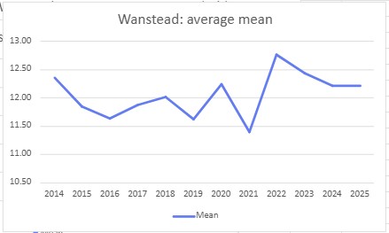
The mean for summer 2025 in Wanstead finished 19.8C, 1.8C above the 1991-2020 average and the second warmest summer in a local record going back to 1797. The figure was just 0.2C short of the warmest summer in 2022.
It was a dry season; just 84.5mm of rain was recorded, the driest for three years and 21st driest to 1797.
Taking a broader view of Greater London, using Met Office statistics for St James’s Park and Heathrow, reveals that summer, as an average of the three, finished second warmest, just 0.174 behind 2022.
In terms of rainfall it finishest 22nd driest with an average of 92.2mm.
Some 590.5 hours of sunshine were measured at Heathrow, 105% of average and the sunniest for 3 years.
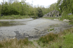
The very dry spring had already taken its toll on the Ornamental Waters, Wanstead Park
The period around the autumnal equinox appears to be getting wetter in this part of the UK.
Since 9am on Sunday 36mm has fallen at Wanstead, some 60% of the monthly total so far! Elsewhere, not too far away near Milton Keynes, Flitwick has recorded 124mm!
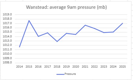
A look at the local stats shows that the week either side of September 22nd has been getting wetter since 2010.
A look at the rolling 10-year average since 1960 shows an increase since 2011.
Since I wrote the original blog on London droughts in July 2018 there have been five more meteorological droughts.
The latest, as I write this on August 8th 2022, now sits joint 2nd in longest droughts in this area.
The rolling 12-month rainfall total has now reduced to 457mm; the lowest since 2017, and low given that the annual Jan-Dec rainfall average here is 602mm. At this point last year the rolling 12-month total was 818mm!
Looking further back, at a monthly rainfall series that goes back to 1797, the opening seven months of this 2022 are the 6th driest.
Whatever way you look at it this area is desperate for rain.
Compiling a list of sunless, rainy days revealed some interesting spells of wet weather – the most miserable runs of June days in the capital since 1959.
First up was a three-day spell starting on June 25, 1974. Some 34.3mm of rain was recorded.
Next was a three-day spell starting on June 23, 1991. Some 26.3mm of rain was recorded.
Another three-day spell started on June 25, 1997. Some 36.2mm of rain was recorded.
Finally, and most recently, a two-day spell this month that began on June 17th. Some 28mm of rain was recorded.
The above spells all happened around the date of the ‘June monsoon’ singularity which has a probability of 77 per cent. Though the fact that these occurred 47 years, 30 years and 24 years ago shows that these extreme cases happen a lot less than three years in every four the singularity would suggest.
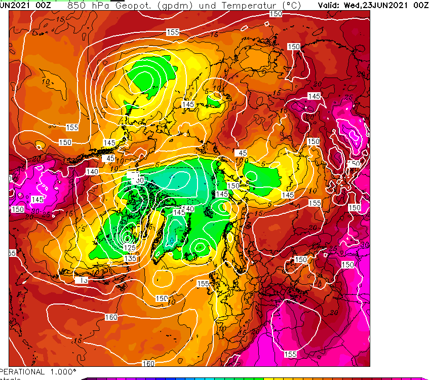
Comparing the current Northern Hemisphere pattern with 1974 suggests that while there’s just as much heat around at 850mb as there was 47 years ago, including an extreme heatwave over some Nordic countries, the air above Greenland appears colder.
Spring in this neck of the woods was really mixed.
A chilly start to March became fairly benign before ending with the warmest March day locally since at least 1959.
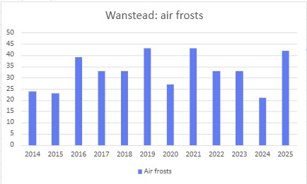
April then turned much colder and drier; just 2.4mm of rain fell during the month – the driest April since 2007 and fourth driest in a local rainfall series back to 1797! Sunshine was abundant with over 200 hours. But clear skies at that time of year, with a polar continental airmass, often means air frost. And the ten recorded overnight was far higher than normal.
May saw things warm up slightly but the month still finished a degree colder than average. Some 80mm of rain fell which is over one and a half times what we’d normally expect. The wettest May since 2007 – the month playing catch up on the total absence of April showers that bring the spring flowers! It was a dull month with only 126 hours of sunshine, 69 per cent of average – the dullest since 1990 was third dullest back to 1881.
In terms of flora and fauna the colder weather played havoc with the trees, bud burst coming much later than recent years. As I write this on June 6th some of the later budders like false acacia have only just come into full leaf. The birds, as they normally do, just seem to get on with it raising their young. I’m not sure what the food supply has been like but judging by the amount of healthy juvenile fledglings I’ve seen I would guess that it has been a good season so far?
Here’s the stats. March 8C (+0.3) 30.9mm (76%) 90.9 hours (84%)24.1C on 30th (a record that had stood since 1965) April 7.2C (-2.6) 2.4mm (5.5%) 202.6 hours (127%) 10 air frosts in April, much higher than normal May 12.1 (-1) 80mm (156%) 125.6hours (69%) Spring 2021: Mean : 9.1C (1.1C below average, coldest since 2013, 111th coldest) Rain : 113mm (84% of average, wettest since 2018, 150th wettest ) Sun : 425.4 hrs (94% of average, dullest for three years. 51st dullest) The average masked extremes.
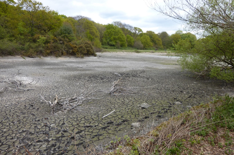
Lack of rainfall and a broken pump have been cited by City of London Corporation as the main reason for the shocking levels of the ponds through the park.
The Ornamental Water by the Grotto is virtually dry. Images courtesy of Ralph Potter
The plight of the water courses has been well documented of late; a press release from the Corporation explains the catalogue of issues hampering efforts to address the problem. Closer scrutiny of these reasons, however, suggest that too much is being blamed on the weather.
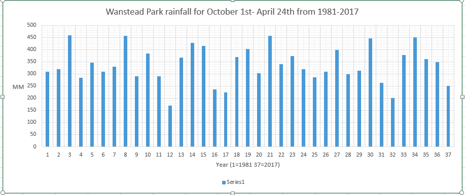
A study of local rainfall back to 1981 suggests that though the ground water replenishing season (October 1st – April 24th) has been dry it is by no means out of the ordinary.
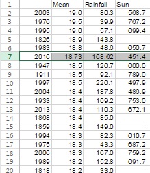
As you can see from the graph the rainfall here has gone up and down like a yo-yo and 2016-17 is only the fourth driest period: 1991-92, 1995-96, 1996-97 and 2011-12 were drier.
The Corporation’s press release states: “2015-16 was a helpfully wet period for us…”
Wrong. 2015-16 was average. And if you consider annual rainfall 2015 saw 92 per cent of average rainfall recorded; 2016 was 93 per cent – placing 58th and 66th in driest years since 1797. Nothing out of the ordinary.
“2016-17 has, however, been an especially dry period with below average rainfall since Spring 2016.”
Wrong. See above detail. There have been three drier periods since 1981. And since March 2016, only half of the months have been notably dry, a period that included the third wettest June since 1797.
“January to March 2017 has seen roughly 50% less rainfall than average”
Wrong. January to March rainfall was 94% of the 1981-2010 average
April has been dry, and could be among the top 5 driest back to 1797, but it seems the Corporation are trying to blame nature instead of years of neglect on their part.
The past months have seen much of Heronry Pond dry out. Image by Ralph Potter
The situation is in stark contrast to CoL’s other open space, Hampstead Heath, which has recently seen the completion of a £23m project to make safe the ponds there. CoL has deep pockets yet they have dithered for years over spending £25,000 to renovate the Coronation Bridge – and offer the people of Ilford a route into the park.
Figures released by CoL show it has only invested £1.23m in Wanstead Park over the last five years, compared with £50m spent in Hampstead Heath.
We are constantly told that problems in the park are ‘in hand’ yet progress on anything is painfully slow – and action to repair the pump has sadly come too late for much of the wildlife on Heronry Pond.
People from far and wide use Wanstead Park – they really deserve better!
You can view City of London Corporation’s press release here
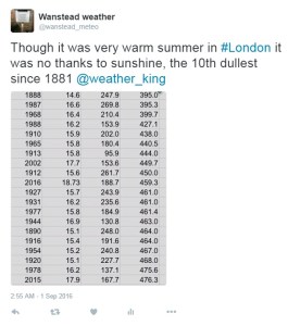
Last month was the second warmest September in a local record going back to 1797! The monthly mean finished 17.8C, 2.4C above average. Despite being an ‘autumn’ month September was actually a full degree warmer than June!
September 2016 was the second warmest in a local record back to 1797, though we’re talking by fewer than tenths of a degree.
The hottest September day since 1959 was recorded on the 13th when 33.1C was reached, the sixth equal hottest in the local daily record back to 1848.
The month also saw the warmest minimum recorded since 1959 when the mercury failed to fall below 18.7C on the 6th.
It was another very dry month, the third much drier than average month in a row: just 27.7mm fell, 24 per cent of average, making it the driest September since since 2007 and the 12th driest in the local record.
Like August, the month only falls down in terms of impressiveness when sunshine hours are considered. Some 119 hours were recorded, that’s 85 per cent of average, making it the dullest September for 15 years.
Air frosts: 0, Ground frosts: 0
So what has September got in store weatherwise? The models on the 1st suggest that a large Scandinavian high will become established to our NE bringing lots of settled weather and showers on coasts. There’s obviously the chance of trough disruption as the month progresses if the anticyclone’s influence declines.
Beyond the grasp of the models my usual long range outlook method falls down this month due to September’s warmth and dryness – there is nothing within +/- 10% of September’s statistics. I would guess, however, that we are looking at another drier than average month with frost becoming a risk as the month progresses where skies clear. There is also the chance of more pleasant autumn days where skies are clear during the day.
My September outlook for temperature was poor. I predicted a mean of 15.3C (outcome: 17.8C). It was much, much drier than I thought: 300mm (outcome: 27.7mm). Sunshine was poor: 140 hours (outcome: 119 hours).
Here follows the full weather diary for September…Full stats for the month here:http://1drv.ms/1rSfT7Y
1st: Sunny start but cloud gradually increased until it was overcast by 6pm. Clear spells overnight but warmer than previous nights.
2nd: Cloudy though some brighter intervals.
3rd: Sunny start, cloud began to pile in at 12.30pm with rain arriving at 5.30pm, this fell through the evening with some showers in the early hours.
4th: Bright, breezy start but rapidly turning cloudy and dull. Some rain overnight.
5th: Light rain and dull to start – this quickly clearing to cloud by 3pm. Things remained cloudy with a muggy night.
6th: Cloudy, dull and muggy start after warmest September night on record. Another warm night though muggy.
7th: Cloudy to 11am though sun breaking through as drier air arrived. Feeling humid.
8th: Sunny start but with plenty of cumulus, this quickly decreasing to leave clear sky.
9th: Cloudy morning though sky seemed to periodically clear of low cumulus before becoming overcast and very breezy in the afternoon. Some rain overnight and just before obs time.
10th: Cloudy start with patchy light rain, this briefly turning heavy at 1pm before turning occasionally moderate. Dreadful afternoon after recently. Clearing overnight to leave a sunny start.
11th: A glorious sunny day with only the odd patch of cirrus.
12th: Bright start with some sunshine, clouding over with a few splodges of rain with warm front. Then sunny and very warm.
13th: Sunny start with a few cirrus and castalanus around. Breezy at times with the thermals. The warmest September day since 1959 and 6th equal warmest since 1848.
14th: Sunny start with a few cirrus. A few patches of alto-cumulus later. Very warm but not as hot as yesterday. Warm, pleasant evening. 15th: Sunny with a few wispy cumulus, clearing to hot sunshine. Some alto-cumulus developed at 2pm and towering cumulus could be seen in distance. Thunderstorms reporting to NW of London. Cloudy and warm overnight with eight peals of thunder in the early hours and heavy rain.
16th: Light to moderate rain through the morning, petering out at 1.30pm.
17th: Cloudy, cool and breezy all day, at times dull.
18th: Cloudy all day, a bit warmer than the previous two days.
19th: Cloudy start though with sun breaking through briefly at 11am until 1pm then cloudy again. Rain at 1am that didn’t last long enough to register.
20th: Cloudy and fairly calm – a nothing day with odd very light drizzle.
21st: Bright start with cloud breaking to long spells of sunshine before more cloud moved in. Warmer than of late.
22nd: Cloudy but sun broke through giving pleasant afternoon and cool overnight.
23rd: Sunny, gin clear and cold start. Just a few fair weather cumulus through the day.
24th: Sunny start with cloud decreasing. Very warm in sun but cloud and breeze built through the day. Overnight light rain between 6am and 9am.
25th: Bright start after overnight light rain.
26th: Bright start with a few cloud breaks here and there. Heavy shower at 12.15pm with further threat of rain but stayed dry.
27th: Bright start with signs of a cold front moving in from south then cloudy.
28th: Sunny start with patchy cirrus, this tending to thicken at lunchtime to turn mostly overcast with humidity increasing. Breeze also picked up with reappearance of sun mid afternoon. Cloudy, very mild and breezy rest of the day.
29th: Cold front and brief heavy rain swept in at 10.03am. Then intermittent falls until 11.23am.
30th: Sunny, gin-clear start, patchy cumulus bubbling up at 10.30am. Cloud grew thicker around 12 noon with brief shower at 1pm. Then sunny spells and cloudier periods. Another shower just after nightfall then clear. Cloud moved in after 2am with another shower. Early sunshine gave way to moderate showers around 9.45am.
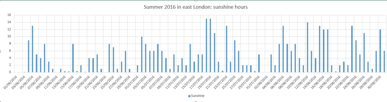
Summer 2016 turned out to be a very decent season overall, the mean temperature of 18.7C (1.1C above average) made it the sixth warmest summer since 1797.
While it wasn’t quite up there with the hot summers of 1976 and 2003 it still produced some notable records. The stormy beginning to June effectively ended with the Brexit vote, a period of 24 hours that coincided with the highest daily rainfall this area has seen since at least 1959.
The multi-cell thunderstorm in the early hours of June 23rd produced 60.8mm of rainfall, nearly half of the month’s total which became the third wettest June in a record going back to 1797. The high rainfall was in complete contrast to July and August and helped skew the overall figure: 168.6mm is 114 per cent over average summer rainfall.
With so much rainfall overall sunshine was affected with only 451 hours recorded, just 80 per cent of what can be expected in an average summer.
July produced another record, this time the highest overnight minimum recorded since 1959. The minimum of 21.1C was recorded during the early hours of the 20th – coming hours after the hottest day of the year: 33.5C – the 14th hottest day on record.
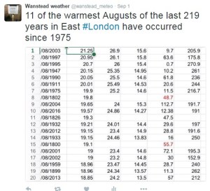
The warm and very dry theme continued into the final month of summer with the warmest August for 12 years, the 10th warmest and 12th driest since 1797.
My summer forecast, when the monthly probabilities are considered, was broadly correct though I didn’t estimate correctly just how warm it would be.
Though there were no records broken August 2016 goes down as a mighty fine summer month, the warmest for 12 years. The mean of 19.5C was 1.3C warmer than average and only 0.1C cooler than 2004.
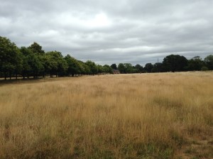
Grasslands around Wanstead Park have gradually turned brown because of the lack of rainfall
The month ended a three-year run of poor or so-so Augusts: in terms of mean temperature the month was the 10th warmest in a local series going back to 1797.
It was another very dry month: just 11.9mm fell, 24 per cent of average, the driest August since 2003 and the 12th driest in the local record.
The month only falls down in terms of impressiveness when sunshine hours are considered. Some 192 hours were recorded, the 59th sunniest since 1797 – 1995 had 80hrs more sun.
Air frosts: 0, Ground frosts: 0
So what has September got in store weatherwise? The models on the 1st suggest the month will start mixed, though any precipitation will be below average. Temperatures remaining on the warm side.
Beyond the grasp of the models my long range outlook method is again hampered by a very dry August. However, the data I do have suggests an average month at 100 per cent probability.
A wetter than average month looks most likely at 75% probability.
The rainfall probability makes me wonder whether we are in for a very unsettled second half of September, the Atlantic cranking into life with the remnants of tropical storms and hurricanes having an ever-increasing influence as the month progresses.
So to sum up: mean 15.3C (average), rainfall 162mm (300%), sunshine 140 hours (100%).
My August outlook for temperature was good. I predicted a mean of 19C (outcome: 19.5C). It was drier than I thought: 30.3mm (outcome: 11.9mm). Sunshine was poor: 239 hours (outcome: 192 hours).
Here follows the full weather diary for August…Full stats for the month here:http://1drv.ms/1rSfT7Y
1st: Cloudy start to 1pm. Rain started at 5pm through to 10pm. A brief interlude before more light to moderate rain through the night 4.30am, then drizzle
2nd: Damp, miserable start – the rain became light to moderate in the early afternoon before drying up – very high dew points through the day.
3rd: Bright and breezy with variable cloud.
4th: Bright start with variable cloud and sunny spells.
5th: Good sunny spells all day – perfect summer’s day, not too much humidity – though an isolated shower passed over at 8pm.
6th: Sunny, clear start. Lots of sunny spells during the day.
7th: Bright start though very breezy. Cloud decreased through the day to leave a gorgeous late afternoon and evening.
8th: Sunny, clear start with lots of fair weather cumulus throughout the day. Cloudier spells mid afternoon.
9th: Sunny with fair weather cumulus up until noon then cloudy afternoon.
10th: Sunny with fair weather cumulus, variable throughout the day. Breezy.
11th: Cloudy start with very brief light rain, barely enough to damp ground. Some sunny intervals later and bright and warm.
12th: Sunny start with a few clouds. Turned gin clear at 11am and stayed clear all day. Feeling hot.
13th: Bright start but turning cloudier. Sunny intervals PM.
14th: Cloudy start breaking to some long sunny spells. Feeling very warm in the sun.
15th: Bright start soon turned sunny with a clearance at 1pm.
16th: Bright start though a lot of haze around. Sunnier later though still hazy.
17th: Sunny with patchy cloud to start, this clearing late morning to leave a clear if rather hazy afternoon.
18th: Sunny if a bit hazy to start, this tending to decrease to leave warm sunshine.
19th: Cloudy with rain threatening. Low cloud at Stansted. Brief rain in afternoon then cloudy.
20th: Dull and overcast at 9am. Burst of heavy rain at 10.15am clearing to sunny spells at noon 30. Rain between 7pm and 8pm and 3am and 4am.
21st: Bright start. Sunny intervals till 3pm then sunny spells.
22nd: Bright after earlier rain at 0719 then sunny spells.
23rd: Clear and sunny start with a few cirrus clouds through the day. Hot.
24th: Sunny, gin clear start. Patchy cirrus through the day. Hot.
25th: Lots of altocumulus and sunny spells but felt sultry due to high dew points.
26th: Cloudy start but gradually decreased to leave clear pm.
27th: Overcast but bright start. Brightness through the day but hazy. Some heavy storms further north.
28th: Overcast until early afternoon, 5 minute shower at 2pm then sunny intervals..
29th: Bright start then sunny spells and cirro cumulus gradually clearing to leave a sunny evening and clear night.
30th: Clear and sunny start.
31st: Bright start though cloud filling in by 3pm, clearing again at 8.30pm


 : 9.1C (1.1C below average, coldest since 2013, 111th coldest) Rain
  : 113mm (84% of average, wettest since 2018, 150th wettest ) Sun
  : 425.4 hrs (94% of average, dullest for three years. 51st dullest) The average masked extremes.


 With so much rainfall overall sunshine was affected with only 451 hours recorded, just 80 per cent of what can be expected in an average summer.
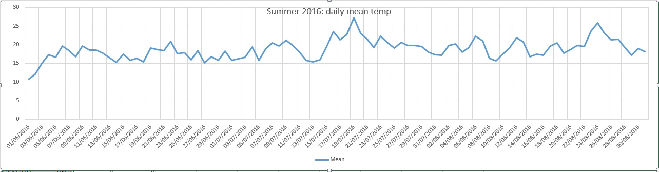


 Beyond the grasp of the models my long range outlook method is again hampered by a very dry August. However, the data I do have suggests an average month at 100 per cent probability.
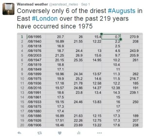 My August outlook for temperature was good. I predicted a mean of 19C (outcome: 19.5C). It was drier than I thought: 30.3mm (outcome: 11.9mm). Sunshine was poor: 239 hours (outcome: 192 hours).
You must be logged in to post a comment.