The outlook for possible snow over the weekend reminds me of a similar synoptic set-up in December 1990 that left large parts of the Midlands northwards covered in deep snow, but that delivered only cold rain to the London area.
2017
1990
The situation in 1990 is explained on the excellent Booty Weather site.
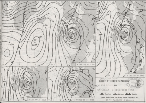
“A low formed dramatically over central England on the 7th, large quantities of rain, turning in many places to snow, fell on its western and northern flanks. On the 7th and 8th very heavy snow fell over northern England, Wales, the Midlands and south west England, with heavy drifting in gale force winds, causing considerable disruption to traffic and cutting power lines.
“The snow did not freeze, however, but melted very rapidly during the next few days, as the temperature rose a little. By late on the 8th, many parts of the Midlands had 20cm or more of lying snow. Acocks Green, Birmingham, reported 42.5cm on the 8th. The Peak District had 38cm at Middleton and 25cm at Winksworth. Newcastle under Lyme reported 28cm, and many other places had more than 20cm. Drifts up to 60cm on motorways in the Derby area, and at Carlton in Coverdale, near Leyburn, a report of 240cm. Snowfall on the 9th in the Dorchester area in 1990 was the heaviest pre-Christmas fall in that area since 9 December 9th, 1967.”
My stats in London suggest that the system was a bit of a non-event here. Another account of December 1990 is covered here.
Met Office synoptic charts, general situation and surface obs for December 8th 1990
I’ve put together a few top 10s of stats for Wanstead, St James’s Park and Heathrow for the month of December.
Probably most notable is how the month in 1978 lurched from being very mild and wet to very cold in under three weeks later, setting up one of the coldest-ever winters.
Some national UK December values according to TORRO
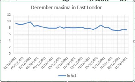
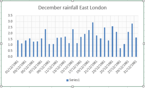
Here’s a couple of graphs showing the maxima and rainfall. Notice the spike just before Christmas day which reflects the singularity which has an 84 per cent probability.
December 2016 was the driest 12th month in over 80 years and the 5th driest in a record going back to 1797.
Christmas day was the second warmest on record in London
The total fall of 8.3mm is just 16 per cent of what normally falls in December, marginally more than December 1933. The mean temperature of 6.1C was 0.5C above average, though 4C colder than the record December last year.
There were 51hrs of sunshine, that’s 125 per cent of average.
The wettest day was on the 10th when 5.2mm of rain fell. The warmest day occurred on the 9th with 14.2C recorded. The lowest temperature occurred on the 28th when the spirit fell to -4C.
The sunniest days were on the 4th and 29th when seven hours of sunshine were recorded.
Air frosts: 8, Ground frosts: 14
Fog, frost and black ice all featured during December
Though January has started on the chilly side in the short term the weather will turn mild. Beyond that there is a suggestion that the weather could turn on the colder side of average with some models suggesting a cold snap with snow around mid-month.
My usual method of prediction to the end of the month has been scotched by the very dry December. The only years that were similar were both far colder than last month – the usual pattern of a dry month being cold or very cold was broken.
With the unprecedented warmth at the North Pole, last year’s odd behaviour of the QBO and a weak polar vortex we are in unprecedented territory in terms of what could happen later in January. My hunch, though, suggests the month will end up average to rather cold with little precipitation. Any cold spell with probably be the short-lived variety with a couple of inches of snow that lasts three days.
So, to sum up, we’re looking at a mean of 4.4C, rainfall: 55mm, sunshine: 39hrs.
In view of the above my forecast last month was very poor: predicted mean 4.4C (result 6.1C). Rainfall: 55mm (result 8mm). Sunshine: 39hrs (result 51hrs)
I have also published a winter forecast covering the London area that you can find here.
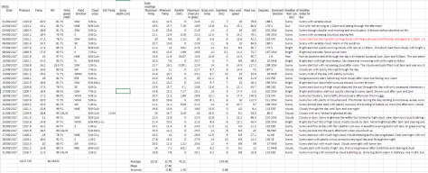
Here follows the full weather diary for December…Full stats for the month here:http://1drv.ms/1rSfT7Y
1st: Sunny start though the frost lifted readily into low cloud and mist to leave a chilly afternoon.
2nd: Cloudy, quiet and cool weather all day.
3rd: Cloudy and quiet all day. Feeling cold.
4th: Sunny , frosty start. Quickly warming up to leave sunny, cloudless afternoon.
5th: Sunny start, then patchy cloud – this thickening before becoming foggy overnight.
6th: Misty start after fog overnight. Cloudy most of the day though there was a brief clearance around midday.
7th: Cloudy most of the day though there was occasional brightness.
8th: Dull day though with a little limited brightness early afternoon.
9th: Cloudy but wth more brightness than yesterday. Very mild. Cloud thickened with light rain around 11am. This gradually grew heavier as the day progressed and was moderate overnight.
10th: Bright start and feeling mild, then cloudier and damp.
11th: Cloudy and dull all day.
12th: Dull all day with light rain early and late. Clearer spells overnight but overcast again by dawn.
13th: Dull with bits and pieces of drizzle up to 11.20am.
14th: Bright start with lots of cirrus and altocumulus – this gradually cleared to leave a warm and pleasant afternoon.
15th: Dull and cloudy with limited brightness.
16th: Dull and cloudy start.
17th: Foggy and dull all day.
18th: Misty start with fog above 90m on cycle ride. Then dull and grey all day. Mild.
19th: Dull and cloudy all day – some spots of drizzle.
2oth: Sunny start but clouded over late morning. Cloudy thereafter with some drizzle overnight.
21st: Cloudy start then sunny. Cloud returned and turned dull and dreary in the afternoon with odd drizzle.
22nd: Bright, misty start
23rd: Cloudy start with breeze beginning to build as a result of Storm Barbera.
24th: Cloudy and dull all day. Very mild. Temp increasing overnight with approach of warm front .
25th: Cloudy, breezy start. Remained dull all day though brightness was seen over the Thames and North Downs, disrupting the SW’ly flow.
26th: Sunny, hazy start and turning colder.
27th: Sunny, frosty start, the air pressure record of 2012 has been broken.
28th: Foggy start, the fog persisting to late morning before sun broke through leaving a chilly afternoon. Frost returned quickly after dark, a clear night.
29th: Sunny and very cold and frosty start. Frost returning after dark with fog forming in the early hours.
30th: Foggy and dull all day, the fog thickening up at nightfall. Approaching cloud lifted the fog and temperature.
31st: Dull and overcast to start – this sticking around all day.
Last month was the second warmest September in a local record going back to 1797! The monthly mean finished 17.8C, 2.4C above average. Despite being an ‘autumn’ month September was actually a full degree warmer than June!
September 2016 was the second warmest in a local record back to 1797, though we’re talking by fewer than tenths of a degree.
The hottest September day since 1959 was recorded on the 13th when 33.1C was reached, the sixth equal hottest in the local daily record back to 1848.
The month also saw the warmest minimum recorded since 1959 when the mercury failed to fall below 18.7C on the 6th.
It was another very dry month, the third much drier than average month in a row: just 27.7mm fell, 24 per cent of average, making it the driest September since since 2007 and the 12th driest in the local record.
Like August, the month only falls down in terms of impressiveness when sunshine hours are considered. Some 119 hours were recorded, that’s 85 per cent of average, making it the dullest September for 15 years.
Air frosts: 0, Ground frosts: 0
So what has September got in store weatherwise? The models on the 1st suggest that a large Scandinavian high will become established to our NE bringing lots of settled weather and showers on coasts. There’s obviously the chance of trough disruption as the month progresses if the anticyclone’s influence declines.
Beyond the grasp of the models my usual long range outlook method falls down this month due to September’s warmth and dryness – there is nothing within +/- 10% of September’s statistics. I would guess, however, that we are looking at another drier than average month with frost becoming a risk as the month progresses where skies clear. There is also the chance of more pleasant autumn days where skies are clear during the day.
My September outlook for temperature was poor. I predicted a mean of 15.3C (outcome: 17.8C). It was much, much drier than I thought: 300mm (outcome: 27.7mm). Sunshine was poor: 140 hours (outcome: 119 hours).
Here follows the full weather diary for September…Full stats for the month here:http://1drv.ms/1rSfT7Y
1st: Sunny start but cloud gradually increased until it was overcast by 6pm. Clear spells overnight but warmer than previous nights.
2nd: Cloudy though some brighter intervals.
3rd: Sunny start, cloud began to pile in at 12.30pm with rain arriving at 5.30pm, this fell through the evening with some showers in the early hours.
4th: Bright, breezy start but rapidly turning cloudy and dull. Some rain overnight.
5th: Light rain and dull to start – this quickly clearing to cloud by 3pm. Things remained cloudy with a muggy night.
6th: Cloudy, dull and muggy start after warmest September night on record. Another warm night though muggy.
7th: Cloudy to 11am though sun breaking through as drier air arrived. Feeling humid.
8th: Sunny start but with plenty of cumulus, this quickly decreasing to leave clear sky.
9th: Cloudy morning though sky seemed to periodically clear of low cumulus before becoming overcast and very breezy in the afternoon. Some rain overnight and just before obs time.
10th: Cloudy start with patchy light rain, this briefly turning heavy at 1pm before turning occasionally moderate. Dreadful afternoon after recently. Clearing overnight to leave a sunny start.
11th: A glorious sunny day with only the odd patch of cirrus.
12th: Bright start with some sunshine, clouding over with a few splodges of rain with warm front. Then sunny and very warm.
13th: Sunny start with a few cirrus and castalanus around. Breezy at times with the thermals. The warmest September day since 1959 and 6th equal warmest since 1848.
14th: Sunny start with a few cirrus. A few patches of alto-cumulus later. Very warm but not as hot as yesterday. Warm, pleasant evening. 15th: Sunny with a few wispy cumulus, clearing to hot sunshine. Some alto-cumulus developed at 2pm and towering cumulus could be seen in distance. Thunderstorms reporting to NW of London. Cloudy and warm overnight with eight peals of thunder in the early hours and heavy rain.
16th: Light to moderate rain through the morning, petering out at 1.30pm.
17th: Cloudy, cool and breezy all day, at times dull.
18th: Cloudy all day, a bit warmer than the previous two days.
19th: Cloudy start though with sun breaking through briefly at 11am until 1pm then cloudy again. Rain at 1am that didn’t last long enough to register.
20th: Cloudy and fairly calm – a nothing day with odd very light drizzle.
21st: Bright start with cloud breaking to long spells of sunshine before more cloud moved in. Warmer than of late.
22nd: Cloudy but sun broke through giving pleasant afternoon and cool overnight.
23rd: Sunny, gin clear and cold start. Just a few fair weather cumulus through the day.
24th: Sunny start with cloud decreasing. Very warm in sun but cloud and breeze built through the day. Overnight light rain between 6am and 9am.
25th: Bright start after overnight light rain.
26th: Bright start with a few cloud breaks here and there. Heavy shower at 12.15pm with further threat of rain but stayed dry.
27th: Bright start with signs of a cold front moving in from south then cloudy.
28th: Sunny start with patchy cirrus, this tending to thicken at lunchtime to turn mostly overcast with humidity increasing. Breeze also picked up with reappearance of sun mid afternoon. Cloudy, very mild and breezy rest of the day.
29th: Cold front and brief heavy rain swept in at 10.03am. Then intermittent falls until 11.23am.
30th: Sunny, gin-clear start, patchy cumulus bubbling up at 10.30am. Cloud grew thicker around 12 noon with brief shower at 1pm. Then sunny spells and cloudier periods. Another shower just after nightfall then clear. Cloud moved in after 2am with another shower. Early sunshine gave way to moderate showers around 9.45am.


 “The snow did not freeze, however, but melted very rapidly during the next few days, as the temperature rose a little. By late on the 8th, many parts of the Midlands had 20cm or more of lying snow. Acocks Green, Birmingham, reported 42.5cm on the 8th. The Peak District had 38cm at Middleton and 25cm at Winksworth. Newcastle under Lyme reported 28cm, and many other places had more than 20cm. Drifts up to 60cm on motorways in the Derby area, and at Carlton in Coverdale, near Leyburn, a report of 240cm. Snowfall on the 9th in the Dorchester area in 1990 was the heaviest pre-Christmas fall in that area since 9 December 9th, 1967.”


You must be logged in to post a comment.