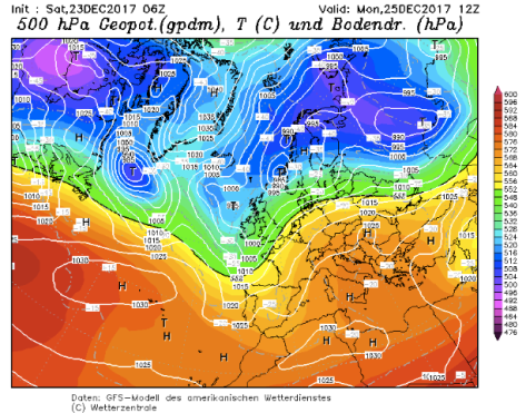
I’m not. And it is not because a glimpse at the latest GFS operational run at T+324z (on the 12th) reveals that many could be sitting down to their festive lunch in mild Atlantic air, with possible frontal rain bringing a miserable afternoon with heavy rain in the evening.
Cold spells in early to mid December often end around the 20th, a momentary change to a more mobile regime. Even the cold winter of 1962/63 saw this mid-December warm up with the snow not arriving until Boxing Day.
I will be keeping a daily eye on the GFS and adding to this blog to watch the daily twists and turns, adding to this blog from here.
Just over 24hrs away now on Sunday 24th and the weather tomorrow is again looking mild,in London, about 11C and breezy at lunchtime with rain spreading in very late evening. Best chance of any flakes over the high ground of Scotland.

On Saturday 23rd, just 54hrs away now, and the GFS op run is again showing the same change to cooler air albeit slightly delayed to previous runs. Temps in London about 10C / 11C, breezy – any rain not arriving to well into the evening. Best chance of any UK snow is Glasgow, into the evening as the cold front clears – and obviously flakes on high ground in the north.

On Friday 22nd, less than 90hrs away, the GFS is again showing the UK on the cusp of a change. Conditions in London look very mild 11C – 13C before dropping back to 5C after a spell of rain in the evening. Best chance of any snow over the highest points of Scotland.

Down to 108hrs to lunchtime on the 25th and the situation still shows the weather regime on the cusp of change with the anticyclone over France pulling away south. High temps in London about 9C or 10C with rain late in the evening. Snow risk across the Highlands as colder air digs in. 
On Wedesday 20th, the synoptic situation on 25th looks on the cusp of a big change to something more unsettled as the high pulls well south of its current position. A heavy band of rain is approaching from the west though it would be well into the evening before it affects London. Best chance of any snowfall if you fancy a flutter is Glasgow.

On Tuesday 19th, Christmas lunchtime appears to be the transition day from the present high pressure dominated weather to something cyclonic. In London a dry, cool and cloudy start will be quickly replaced by a spell of rain that clears eastwards. Max 11C, min 3C as the front clears. Best chance of snow looks west coast of Scotland and Pennines.
A week from today and Christmas day will have already dawned. The GFS 00z op presents an unsettled outlook with a transition from mild to cold; London looks warmest at 9am before a cold front sweeps SE’wards. Best chance of anything wintry falling: west coast of Scotlands and Pennines. Over the last couple of years the pattern has already been locked in to mild but this year’s constant ups and downs suggests the weather type it is all still to play for. 
On Sunday 17th, the weather is looking less settled than yesterday with a weak high pressure much further south over the Pyrenees. A cool NW’ly regime with upper air around -5C, allowing any precipitation to be wintry. A chance of snow west coast of Scotland, Pennines and north-west Wales.

On Saturday 16th, weather on the 25th is under the influence of high pressure centred over Brittany. Quiet weather with a high of 6C or 7C after an overnight frost. There appears little chance of anything wintry falling as the source of the upper air is all the way from the Azores.

On Friday 15th, Christmas day lunchtime again looks like a day in between a relatively settled mild pattern and a cold, unsettled regime with potential for slider lows after Boxing Day. The 25th itself again looks chilly and nondescript. A high of 6C or 7C, light winds and potential for some rain later. Things are in a state of flux so I’d expect detail to change again tomorrow.

On Thursday 14th, midday on 25th is looking fairly non-descript. High pressure sits over the near continent with a declining ridge up to Scotland; the UK sits in a battleground with cold air over the near continent and mild air trying to push in from the Atlantic – most of the UK is just on the chilly side. The best chance of any snow is the east coast of Scotland. Still all to play for but it was this date over the past couple of years that the models started to get a good handle on Christmas day proceedings.
 On Wednesday 13th I notice that the Daily Star reckon we are ‘odds on’ for a white Christmas, yet I can’t find a bookie anywhere to ‘lay’ these odds; at 12 days out there’s no way any model could be ‘odds on’.
This morning’s (12th) 00Z operational run of the GFS has London at 10C with a chance of rain. Best chance of any white stuff probably Aberdeen.


Will you be placing a bet?
LikeLike
Not yet.
LikeLiked by 1 person