Tag Archives: 2013

St Jude blasts through Wanstead

Much comparison has been made of Monday morning’s storm which claimed the lives of four people and 1987. The origin of both storms was down to a combination of a jet streak interacting with a pool of warm air low down. Both storms followed a similar development but clearly 1987 was more optimum. The 1987 storm was slower and further to the west when it developed. This morning’s storm was too much in the jet stream and raced on with less development.

Both the 2013 storm, left, and the 1987 storm followed a similar track as shown on these satellite pictures

From the forecasts made at the end of last week into the weekend it was about what I expected in terms of intensity – though I thought the peak of the max gusts (47.2mph at 0653) would have been shorter. Rainfall from the event was unremarkable – just 17.5mm which started falling around 9pm on Sunday and stopped around 5am. Totals north of Watford were far greater. This rainfall radar image at 0645 was taken within 10 minutes of the highest gust in Wanstead.

Rainfall radar image at 0645 - less than 10 minutes before the highest gust in Wanstead. Notice the curl of the cloud - this is where the sting jet gets its name as it looks like a scorpion's tail. Thanks to MeteoX
Rainfall radar image at 0645 – less than 10 minutes before the highest gust in Wanstead. Notice the curl of the cloud – this is where the sting jet gets its name as it looks like a scorpion’s tail. Thanks to MeteoX

Stations similar to here in Woodford Wells and Laindon all reported maximum gusts of 47-53mph, though with these being sheltered gardens the reality was probably higher – perhaps severe gale force 9 was reached at the storm’s peak here. Andrewsfield, near Braintree, North Essex, recorded 79mph. An animation of the storm’s track clearly shows the path of the sting jet. The Met Office have also released a satellite sequence of events. Of course the storm is no comparison with the Great Storm of October 1987, where a gust of 122 mph was recorded in Gorleston, Norfolk, but this morning’s storm was probably in the top 5 of storms since – and the most potent since the Burns’ Day storm of January 1990.

The tree damage in Wanstead has been worse than I would have expected with a few down on Christchurch Green. My own back yard in Aldersbrook seems to have got off lightly though a small flowering cherry on the corner of Dover Road succumbed. On closure inspection the inside of the trunk was spongy – testament to the fungus that I’d noted had been growing on it recently. Elsewhere, in Wanstead Park, some trees were sadly lost. Friends of Wanstead Park give a brief account of the damage here.

After it left Suffolk the storm raced across the North Sea, still deepening all the while, and caused havoc in Belgium and the Netherlands. Much has been said about the UK media’s obsession with the storm which chiefly affected the south east but Belgian and Dutch news outlets also focussed on the weather. In Brussels people were virtually blown along the street. Falling trees blocked canals in Amsterdam where a cyclist narrowly escaped being hit by a falling tree. There were no reports of deaths across the Channel and some watersports fanatics took full advantage of the wild conditions. The storm, which at one point developed an ‘eye‘, continued its destruction across Germany where this home was almost totally destroyed.

This car had a lucky escape
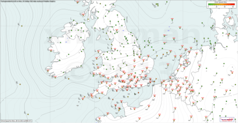
The synoptic situation at 0600z on October 29, 2013
The synoptic situation at 0600z on October 28, 2013
Top  30 windiest places for 0600 UTC, on Friday, October 16, 1987
Top 30 windiest places for 0600 UTC, on Friday, October 16, 1987
top 30 windiest places at 0600 UTC on Monday, October 28, 2013
Advertisement

Heatwave? washout? Or just another changeable British summer?

chicken cloudWith all the talk of heatwaves this week it won’t be long before the media switches from piping on about the UK facing “10 years of miserable summers” to “Is our climate getting warmer?”.

But the simple fact is that the UK’s climate has always varied greatly – some years, as in the last two, the pattern for summer has brought mostly miserable weather. Other years we get a run of warm, dry summers.

A case in point was the heatwave of July 1808. Far removed from images of freezing Georgian winters and miserable summers the July of 205 years ago was among the warmest ever. The monthly mean for July 1808, according to the Central England Temperature series, was 18.4C – the 6th hottest July since the beginning of the series in 1659.

Readings taken by Luke Howard at Plaistow show the build up of heat to the 14th. The series on the right, taken in Wanstead, around 3 miles to the north-east, will be added to by the author as July unfolds
Luke Howard, the ‘father of meteorology’ who at the time lived in Plaistow, referred to the heatwave in his diary on July 13th: “Temperature at 9am 84F. The intense heat of the maximum lasted nearly three hours till about 4pm. At 6pm the temperature was 90F.” Another entry mentions a reading taken nearby. “Another at Plashet, a mile and a half eastward, indicated 96F as the maximum under the shade of a house.”
While Howard’s methods of measuring the temperature ran short of modern standards, his thermometer was hung under a laurel bush, the values still give a valid insight into the heatwave.

Tales of the heatwave, which particularly affected east and north-east England, can be seen in letters sent to local newspapers around the country. Many describe labourers dying from heat exhaustion while working in fields. Farm animals and horses suffered a similar fate. One letter from Hull, published in the Coventry Mercury, said: “At Sigglesthorne, the honey in some beehives melted, ran out upon the ground, and most of the bees drowned in it. At Sutton, a lamb and a dog belonging to the Rev Mr Croft of Rowley, expired in the heat; and several birds dropped down dead, while flying over the streets of this town.”
Of course it is impossible to know about the health of people and animals that died but that birds dropped out the sky suggests extreme heat.

screenWhile temperature records of July 1808 are not unheard of in an English summer one record that remains is the size of the hail – which fell in damaging storms when a thundery breakdown arrived on the 15th.

The main storm missed Wanstead and the surrounding area – though Howard, writing in his Plaistow observatory, knew the weather was on the turn: “Dew on the grass, a fine breeze from ENE. Much lightning in the west this night, a few drops of rain.” Howard would have been referring to all the action about 120-odd miles west where one of the most ferocious storms in recorded history was unfolding.

Much was reported in the local press on the days following the storm which affected an area from Somerset northwards. As well as local records Luke Howard also noted national events in his diary: “After several days of uncommon and oppressive heat the city of Gloucester experienced a storm of thunder and lightning which extended many miles round and exceeded in awful phenomena any one remembered for many years past.”

Trees were “shivered to atoms”, livestock killed by lightning, crops were ruined and countless windows and glasshouses smashed by huge hailstones. A lot of the detail of the storm was compiled by a man named Crocker, then governor of Frome school, Somerset. One account from Batcombe describes a hailstone that measured 13.5 inches in circumference. To give you an idea of the size of a 342mm circumference hailstone I, with the help of my daughters, made one of my own.

It is thought the size of the 1808 hailstone may, along with a storm in 1697, be the national record for hailstone size - being 20mm greater in diameter than those measured in a Horsham, Surrey, storm in 1958
It is thought the size of the 1808 hailstone may, along with a storm in 1697, be the national record for hailstone size – being 20mm greater in diameter than those measured in a Horsham, West Sussex, storm in 1958

Howard’s report continues: “The most tremendous circumstance of this storm was the destructive hail shower which accompanied its progress.”

The Tornado and Storm Research Organisation (TORRO) grades haistorms from H1-H10, where the hail increases in size from 5-10 to over 125mm in diameter. From the historic descriptions the 1808 storm was an H8/9.This exceeds the British record made during the Horsham, West Sussex, storm of September 5, 1958, which produced hailstones up to 80mm in diameter. Hailstones for the 1808 storm were about 109mm in diameter. Since 1650 there have been 119 independent H5 hailstorms in England and Wales.

Since 1900 there has been a halving in the frequency of recorded destructive hailstorms. Scientists are undecided on whether this is a result of climate change or just a variability of the British weather. But any future uptick in destructive hail should be tempered by this historic record.

It is my belief that people’s current expectations for summer were raised to unrealistic levels when we had a run of warm, dry summers a few years ago. The fact is that because of our maritime climate warm, dry summers occur in this country only occasionally. ‘Default’ summer weather is changeable, rather cloudy and, for many in the north, rather cool

So, if any media outlets do start coming out with any stories of “unprecedented heat” or “worst storm in history” bear in mind that it has probably all happened before.

Scott Whitehead
@wanstead_meteo
http://www.wansteadweather.co.uk