Tag Archives: wanstead

April 2016: rather cold and thundery

April 2016 has seen more occurrences of thunder than we can expect during a typical July.

radar hail
About an inch of hail collected on borders in gardens in Plaistow during a thunderstorm on 29th. This stuck around for over an hour thanks to the low humidity

A persistent flow of unstable Polar maritime air, coupled together with strong sunshine, provided the perfect ingredients for some really beefy showers.

The mean temperature of 9C was 0.8C cooler than average, the coldest April for three years and in stark contrast to the previous two Aprils that were mild and very dry. Air frost, notable for its absence in the previous two Aprils, returned with four incidences where the temperature dipped below freezing

Apart from a dry slot in the third week rainfall was fairly steady: 52.5mm is 124% of average for this area. It was the wettest April for four years.

bracka20160415
A depression on 15th led to the wettest 24hrs of April

Sunshine was just below average. Over 153 hours were recorded, 96% of what we can expect to see during an average April.

The wettest day occurred on the 15th with 15.9mm, rain associated with a depression that ran along the Channel coast out into the North Sea, a system that heralded the colder pattern that defined the rest of the month.

Air frosts: 4, Ground frosts: 12

So what has May got in store weatherwise? The models on the 1st suggest that rather warmer weather will develop as we finally lose the northerly-sourced airflow and low pressure across the UK.

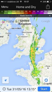
hail radar
The radar on 29th shows a thunderstorm right over Plaistow to the south of Wanstead

Low pressure to the NW will become influential with strong and milder WSW winds driving wind and rain bearing fronts east and SE across the UK late on Sunday and Monday. A bright and brisk NWly flow with sunshine and showers then looks likely to be replaced by a ridge of high pressure and drier weather. It will begin to feel quite warm in any sunshine across the south from midweek.

Beyond that the outlook is uncertain though it appears warmer, if changeable, conditions will prevail.

Beyond the grasp of the models my long range outlook method has conflicting signals. The highest probability is 32% for something rather cool. Average is 28% while rather mild comes in at 20% probability. Something cool comes in at 12%, while mild is 8% probability. Both cool and very mild have a probability of just 4%.

A wetter than average month looks most likely at 48% probability. Sunshine probably about average.

So to sum up: Mean: 12.8C (0.2C below average), rainfall 58mm, sunshine 179 hours.

My April outlook for temperature was good. I predicted a mean of 9.2C (outcome: 9C). Rainfall was also good: 57mm (outcome: 52.5mm). Sunshine also good: 149 hours (outcome: 153.9 hours).

Here follows the full weather diary for April. To view full stats follow this link:http://1drv.ms/1kiTuzv

1st: Sunny start though lots of haze around from late morning.
2nd: Sunny until 2pm before cloud then light rain spread in – this lasting into the evening.
3rd: Sunny start with hazy cumulus building through the day.
4th: Bright start though lots of cloud around. Some gin clear spells of sunshine.
5th: Sunny start though with variable cloud through the morning.
6th: Drizzly start, giving way to sunny spells and showers.
7th: Cloudy after recent light rain. Windy and cold. Some heavy showers mid to late afternooon with flash of lightning and thunder at 4pm and hail >5mm.
8th: Bright start though with much cloud around. Some brief sunny spells and v light showers.
9th: Cloudy, damp start after morning rain. This broke to sunny spells at 1pm ish. Cloudy again later but clearing at dusk to allow a frosty night.
10th: Sunny start but soon turned hazy with keen, cold SE wind building through the day.
11th: Cloudy start but brief brightness early afternoon. Rain at 2.15pm – this lasted until 5pm. More rain in the early hours, heaviest just before 5am.
12th: Bright start though hazy with lots of cirruo stratus. Clear and cold overnight.
13th Glorious sunny start and warm in the sunshine. Some patchy cloud at times. More cloud bubbled up late afternoon with a shower at 8pm and midnight. Clear and cold overnight.
14th: Sunny start though with much more cloud at times to 2pm. Showery rain in the evening lasted through the night.
15th: Cloudy with rain at 9.45am until 10.15 then turned a bit brighter before cloudy again at 11.45am. Rain set in at 12.30pm with thunder at 1.07pm then rain on and off into the evening. Clearing overnight and cold.
16th: Cloudy and cold start. Stayed cloudy all day with brief light rain shower. Cold and frosty overnight.
17th: Sunny, gin clear start with cloud gradually bubbling up. Sunny periods throughout the day.
18th: Sunny start with cumulus bubbling up.
19th: Mostly sunny start but then turned very cloudy. This cloud cleared just before noon.
20th: Sunny, clear start with just a few cirrocumulus drifting around during the day. Cold wind.
21st: Bright start but much cloud around. Some spells of hazy sun through the afternoon.
22nd: Cloudy, cold feeling start. Rain by 5pm, this heavier than expected. Next day dawned clear but cloud soon bubbled up.
23rd: Sunny start, cloud bubbled up with a shower at 12.25pm, clearing by 1pm. Early rain on 24th before obs time.
24th: Bright start, cloud bubbled up with light shower at midnight.
25th: Cloudy, cold start with lots of Arctic cumulus. Showers soon arrived that were mostly sharp but brief and heavier in the east. These cleared to leave a cold, breezy night.
26th: Sunny start but cloud quickly bubbled up. Some heavy showers of soft hail with odd snow flake. Thunder at 2.45pm.
27th: Sunny start though cloud quickly started building with snow and soft hail at 12.30pm. Further showers at 1712 and 2330. Clear, cold and frosty overnight.
28th: Sunny and mostly clear up until  12 noon.
29th: Sunny start though cloud quickly bubbled up. Some very heavy hail in Plaistow with an accumulation of one inch – this hung around for a while due to the low dew point and low humidity – less in Wanstead. Thunder and lightning too.
30th: Sunny, clear start though cloud began to bubble up. Felt cold in the wind as it became overcast last afternoon. Cleared overnight to give frost.

bluebells
Another superb display of bluebells burst into life in Chalet Wood, Wanstead Park, this month

March 2016: cool and wet

With the meteorological winter over the first month of spring saw the weather return to its modern type: cooler than average just when most people are looking for warmth.

squalllengthofuk
The squall of March 26th ran the length of England

The mean temperature of 6.7C was 1C cooler than average, the coldest March for three years and the first month more than 1C below average since last September.

The wet end to the month tipped the rainfall statistic well above average: 60.3mm is 148% of average for this area. It was the wettest March for eight years, notable because of a 14-day dry spell during the middle part of the month.

Sunshine was just above average. Over 116 hours were recorded, 107% of what we can expect to see during an average March.

The wettest day occurred on the 27th with 14.4mm, rain associated with blustery weather fronts from Storm Katie.

Air frosts: 7, Ground frosts: 14

So what has April got in store weatherwise? April is often a month when we can see huge swings in the weather from day to day as the natural warming of the atmosphere competes with the decaying coldness of northern latitudes.

squallonsynop
The squall of March 26th ran the length of England

This often results in big showers and vast temperature differences not only day to day but between night and day too. All of the above is going to be on offer over the coming few weeks if the model output on the 1st is correct. A warmer phase will begin the month as winds switch southerly, drawing warmth from Spain. However, with low pressure close big showers and outbreaks of rain should be expected. Then as the low switches to the NE of the UK the door opens next week for colder NW winds with further rain or showers and chillier air. A lot of output strengthens this northern sourced air through the second week and with low pressure never looking likely to be far from the UK we will be looking at lots of showers and spells of rain.

Beyond the grasp of the models my long range outlook method suggests the April mean will be average or just below at 60% probability. Rather cold comes in at 20% while cold has a probability of 20%. There appears no chance of something mild.

squall26032016
The squall of March 26th ran the length of England

A wetter than average month looks most likely at 40% probability. Sunshine probably about average.

So to sum up: Mean: 9.2C, rainfall 57mm, sunshine 149 hours.

My March outlook for temperature was good. I predicted a mean of 5.9C (outcome: 6.7C). Rainfall was way off: 31.6mm (outcome: 60.3mm). Sunshine also out: 68 hours(outcome: 116 hours).

Here follows the full weather diary for March. To view full stats follow this link:http://1drv.ms/1kiTuzv

1st: Drizzly start turned to steady rain at 10am – this lasting past lunchtime but drying up to leave a cloudy afternoon. Very sharp squall blew threw at 2am with brief intense rainfall.
2nd: Bright start but soon turned very blustery and showery. Brighter after 3pm but cold as dew point fell away.
3rd: Sunny, cold start. Cloud bubbling up late morning.
4th: Sunny, gin clear start. Cloud bubbled up through the day. Clearing in the evening to leave a very cold early hours. Light rain moving in at obs time.
5th: Cloudy start with small area of rain around 10pm. Brief brightness at noon before more light rain moved in. Clearance again at 3.30pm. Small hail <5mm at 5pm. Clear spells overnight.

squallfall6c
The squall of March 26th ran the length of England

6th: Sunny, cold start. Coud bubbling up late morning.
7th: Sunny, cold start with light winds. Variable cloud but feeling cold, especially so overnight.
8th: Cloudy, calm and cold start.
9th: Very light drizzle am before briefly brightening up. Heavier rain pushed in between noon and 2pm. More rain at intermittent periods into the evening.
10th: Cloudy until 2pm. Cleared at dusk to leave a frosty, cold night with thick fog patches on Centre Road.
11th: Sunny start with early mist clearing. Variable cloud through the day. Clear spells up to midnight but then tending to cloud over.
12th: Cloudy start tending to brighten up though sunshine remained mostly wintry.
13th: Cloudy start quickly cleared to leave sunny morning. Pleasant until a keen N’ly wind set in.
14th: Bright start with cloud quickly breaking, cold wind.
15th: Cloudy and dull start. Mostly cloudy through the day.
16th: Bright start but cloud filling in by 10am. Mostly cloudy all day
17th: Sunny and clear until 11am – patchy cirrus thereafter.
18th: Cloudy, cool start – the cloud lasting past 12 noon.
19th: Cloudy start – very brief drizzle. Brief brightness just before 10am then cloudy.
20th: Cloudy start brief sunshine at 10am-ish before cloud spilled across. Another clearance at 11am before cloud returned for afternoon.
21st: Cloudy until brief sunny spells at 10.30am. Much milder for a time before a mostly cloudy afternoon.
22nd: Mostly sunny all day with just a few cumulus.
23rd: Cloudy all day
24th: Cloudy, chilly start. Rain spread in by 1pm and turned heavier in the evening, clearing around 3am to showers. Sunny dawn.
25th: Sunny start with just patchy cumulus
26th: Cloudy with intermittent light drizzle. Very heavy squall at 6pm brought 5C fall in temperature.
27th: Sunny start but with some very dark clouds around. Squally winds and showers thereafter at 11.30 and 2.30pm.
28th: Cloud and rain to start and very windy due to Storm Katie, becoming fine by mid afternoon though heavy showers moved in.
29th: Bright start with cumulus dotting the sky. Cloud thickened up during the day with heavy showers in the evening.
30th: Sunny start with fair weather cumulus doting sky – this lasting all day.
31st Sunny, misty start


Blitz bombs bring yet more tragedy

With the arrival of spring the people of Wanstead and the surrounding region must have thought that the terror of bombs raining down was at an end. Just one raid in February that damaged a few houses was in sharp contrast to the devastation wrought by the Luftwaffe since September.

19th
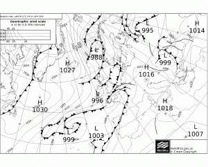
Synoptic chart for March 19th 1941

But further horror lay in wait in March when four members of the Civil Defence Services, two of them young lads, would lose their lives while heroically carrying out their civic duties.

March continued the theme of the wet, miserable and dull winter. The early part of the month was unsettled with heavy rain at times. On the 6th, over 13mm fell. During the second week it became dry with sunny periods. There were some frosty nights and lingering fog. On the 12th, the maximum temperature was only 5°C. Temperatures slowly rose during the third week.

The morning of the 19th dawned cold and frosty. Patchy fog soon lifted under the warm spring sun – it was the second day running the region was bathed in over five hours of sunshine.

The fog soon returned after dusk but plummeting temperatures were no excuse for the wardens at Post 41 ‘F’ District to undertake their nightly duties from their Aldersbrook Tennis Club headquarters. This area of south Wanstead received a real battering from the early days of the Blitz, earning the nicknames “The Battle Field” or “Hell Fire Corner”.

The following impression of that night is written by one who was at the scene:

“The wail of the siren opposite the Post announced at 8.15pm the arrival of the raiders. The Post personnel saw a startling sight. The Flats were a sea of flame. Thousands of incendiaries were burning on the open space. The guns roared. It was obvious that the enemy was making a concerted and determined attack. Bomb flashes stabbed the blackout. Planes droned overhead. The batteries on the Flats joined those further away in putting up a terrific barrage.

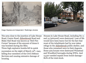
At 8.50pm, three high explosive bombs fell in Lake House Road, damaging a number of houses and partly demolishing Nos 14 and 31. A few casualties resulted, one being a man who was trapped in the doorway of No. 14. Wardens heaved on the obstruction to release him. Gas escaping in the same house caused a fire. This was quickly dealt with and the flames smothered. A nearby barrage balloon had burst into flames, illuminating the scene with glaring brilliance and revealing the widespread damage.

Screen Shot 2015-07-28 at 12.37.33At 9.20pm this first incident appeared closed, and services were awaiting the result of a final search and check-up before being dismissed. Then a parachute mine landed. It exploded a few yards from Aldersbrook corner on the Leytonstone side. A house in Lake House Road, already badly damaged, tottered to destruction. Number 11 caught fire and was destroyed. Loss of life would have been heavy but for the fact that most of the inhabitants had by now taken refuge in the Aldersbrook public shelter, and those who remained were in their dugouts.
The attack died down. Wardens returned to their posts – but the number for 41 was sadly lacking. The two boys’ bicycles stood in their usual place. ‘Busy somewhere’ said the chief. But the absent ones did not return, and a search was made. They were found – in the mortuary, three of them. It was known that two others had been taken to hospital. Warden Barnett was one of these. He died next morning of his injuries.

Just before the mine exploded, the messengers had been giving assistance in one of the less badly-damaged houses. Broome, although officially not on duty, had rushed out to lend a hand. Warden Hutton was endeavouring to turn off the gas at No 14 when the mine fell.

So the four from Post 41 died doing their duty on the Home Front. The two boys, pals in the service, sleep in one grave in Old Wanstead churchyard. The two men lie close by, in Ilford Cemetery.

A few days later their comrades stood silently at attention as the funeral cortege halted outside the Post. A Union Jack covered each of the four coffins.

The four members of the Civil Defence Services who gave their lives were: Thomas Hutton, 44, a warden, of Blake Hall Crescent, Wanstead; William Barnett, 36, a warden, of Belgrave Road, Wanstead; Roy Broome, 17, a messenger, of Lake House Road, Wanstead; and Herbert Stower, 18, a messenger, of Clavering Road, Wanstead.

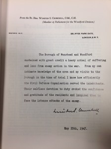
churchill
Winston Churchill’s letter to his constituents

As spring wore on the weather remained mostly miserable though raid incidents lessened and petered out in May. Wanstead and Woodford had its last bombs of the period on May 10th.

In total 129 people lost their lives and 194 were injured during the campaign. This figure would nearly double when the next phase of the bombing, using V1 flying bombs and V2 rockets, would begin three years later in June 1944.

It is hard to imagine how people coped with the constant barrage of bombs during the Blitz. What seems to get lost in articles and historical texts I’ve read is just how grim the weather was at the time – remember this was a time before central heating. Not only were bedrooms freezing cold people must have laid there wondering if they were going to see morning.

It seems to be a human condition that when we are faced with adversity we just find a way of ‘getting on with it’ as best we can.


Is London heading for a hot summer?

Before I’m accused of going all Daily Express the following is based on winter statistics for the London area and other variables rather than the latest expert hopecast.

Even before looking at the data in depth the chart below shows that a warmer than average summer is more likely after a mild winter. The winter just gone was the third mildest in a record going back to 1797.

combined

There are some real corkers in that list, including 1995 when this area recorded the driest August on record. Other notable summers included 1990 – England in the semi-finals of the World Cup and another notably fine August: the then hottest UK temperature was set that year when a maximum of 37.1C was recorded at Cheltenham – a record that lasted until 2003. The year 1989 also stands out with a notably sunny summer.

So far, so good. But what about rainfall? Some 145mm of rain fell this winter – pretty much on the nose average for this region. Combining warm winters with similarly average rainfall gives the following list.

with similar rain

Though some years have disappeared there are still some decent summers, and notably sunny too. The year 1975 stands out as does the sunniest summer on record, 1911! Both were also very dry summers.

Altough the teleconnection with El Nino is tentative in our part of the world the winter seemed to follow the pattern of most positive ENSO episodes, so it is worth having a look to see where the data goes. The latest forecast by NOAA suggests:

A transition to ENSO-neutral is likely during late Northern Hemisphere spring or early summer 2016, with a possible transition to La Niña conditions during the fall.*

If the forecast goes to plan the second ‘rainfall list’ would narrow further:

Screen Shot 2016-03-08 at 02.44.05

Viewed by graph reveals that ENSO values of all the years decreased over the course of the year. Series 1 is 1998, series 2 is 1983 etc.

Screen Shot 2016-03-08 at 02.48.01

In conclusion, the results would suggest that there is a 66% chance of a decent summer with below average rainfall and above average sunshine. In terms of details June 1st is still a very long off in meteorological terms – so whether it includes any heatwaves that would put it my premier league of hot spells is anyone’s guess at this range.

If it’s anything like 1959, 1975, 1983 or 1998, however, I think most folk will be happy.

*The above contradicts some forecasts which suggest a continuation of the general pattern that persisted during the winter: warm SSTs in the Atlantic / warm water south of the Grand Banks were largely responsible for the cyclonic westerly type of weather that caused the mild weather. In summer this would cause changeable weather rather than long spells of settled weather.


January 2016: average and wet

The coldest night in three years was recorded last month together with the first lying snow in January since 2013 – though you had to be up early on Sunday 17th to see it.

epping snow
Snowfall on the 17th was just over 1cm deep at High Beech. In Wanstead it was just a thin covering that was gone by midday

For anyone looking for ‘traditional’ winter weather it was pretty desperate stuff and seems a continuation of the mild winters of the past three years.

Apart from a mild final week much of the month was rather cold with a couple of sharp night frosts that affected many early daffodils that bloomed during the super mild December.

Rainfall of 65.8mm was 124% of average – very similar to last January’s total. Mean temperature for the month was 5.8C, 0.6C above the 1981-2010 mean. It felt far cooler, however, because the December mean was 5C above average.

high beechSunshine was just above average. Over 54 hours were recorded, 108% of what we can expect to see during an average January.

The wettest day occurred on the 10th with 11.6mm.

Air frosts: 6

Ground frosts: 18

So what has February got in store weatherwise? There is no sign of any longer term changes in the pattern of synoptics across the UK. All models continue to suggest a very volatile jet stream with resultant low pressure close to or across the UK for much of the first half of February.

new street
The snow on the 17th fell during the early hours of the morning

This week westerly winds will remain strong with severe gales in the north in association with Storm Henry over the next 36 hours. The current mild and damp conditions in the south should be replaced with colder, showery air moving south later on Monday, lasting into Wednesday. On Thursday another large warm sector will move up across the UK from the SW returning mild and damp conditions.

At the weekend all models show low pressure areas taking a much more southerly route across the UK with gales and wet weather. While no cold weather looks likely there may be incidences of very heavy and thundery showers. Only GFS on Monday is showing any hint of more settled, colder weather at the end of the period.

Using my long range method February is looking average, very dry and dull.

A mean of about 5.9C, just over average, is the highest probability at 71%. Something ‘rather mild’ comes in at 29% probability.

Rainfall is looking low: 15mm represents something 38% of average.

Sunshine totals will be low and it could be a dull month, around 60 hours of sunshine, that’s just 82% of average.

My January outlook for temperature good. I predicted a mean of 5.2C (outcome: 5.8C) with 59mm of rain (outcome: 65.8mm).

Here follows the full weather diary for December. To view full stats follow this link:http://1drv.ms/1kiTuzv


1st: Bright after sunny, clear dawn before clouding over with light rain. Rain at midnight.
2nd: Cloudy start after early overnight rain. Rainy spells and blustery throughout the day.
3rd: Drizzle to start then damp before more rain moved in at 11.30am – this fell intermittently through the day and evening and was often heavy.
4th: Bright, damp start after overnight rain. Some light outbreaks up to 2pm.
5th: Sunny, clear and cold start with contrails dotting the sky. Clouding over later with rain after 6pm. Misty around midnight.
6th: Bright, very damp start. Mostly cloudy with rain in the evening and overnight.
7th: Dull start with outbreaks of rain spreading in, some heavy and very blustery. Drying up after lunchtime though feeling cold. Cool overnight with frost on cars with a very brief shower on school run.
8th: Bright start though light showers around. Gradually clouding over. Clearer spells overnight and cool.
9th: Bright start though with plenty of cloud around. Showers, some heavy with small hail at 8.30pm. Clear spells overnight.
10th: Bright start after overnight rain. Cloud gradually decreasing to leave it clear at noon. Cloud returned after dusk and thickened up around 9pm. Heavy rain from midnight.
11th: Cloudy, damp and cold start. Some breaks after noon then clear spells overnight and cold.
12th: Sunny, cold start. Clouding over at midday to leave cold-feeling afternoon and overnight – too much wind for a frost.
13th: Bright, cold start but turning mostly cloudy. Rain in the evening and on ride home.
14th: Rainy. cold start, then cloudy with sunny intervals. Cold air digging in from midday.
15th: Sunny all day with just a few cirrus. Took a while for frost to form properly.
16th: Sunny, frosty start with just a few cirrus. Variable cloud and evening in London felt freezing. Some drizzle, this turned heavier and by 4am thick flakes were falling to give a thin covering. Some 1cm at High Beach during a bike ride.
17th: Cloudy start. Thin covering of snow (<1cm) thawed by lunchtime. Cloud built into afternoon to leave chilly evening.
18th: Bright start but sunshine was weak so felt cold. Mostly clear into the evening allowed for an early frost. A classic radiative cooling night until the early hours, assisted by a very gentle low-level flow off the continent where there were some very low dew points. Between 2am and 6am there was some thin, high-level cloud that drifted across, which stopped the radiative cooling. Warmth from the ground then briefly lifted the temperature until, once more the cloud cleared after 6am and allowed the temperature to fall again to its minimum of -5C at 0809z. There was also a little mixing of the layers of air between 2 and 6 which would also have had a cooling effect. Had it not been for the cloud I’d suggest that the low could have fallen to -6.2C, which would have been the coldest since February 2012 when it fell to -9.2C over full snow cover.
19th: Sunny all day with occasional alto-cumulus drifting across. Another cold night, the coldest in 3 years.
20th: Bright start with lots of scattered cumulus. Sunnier early afternoon and less cold. Another frost quickly forming after dark.
21st: Frost lifting quickly then cloudy with limited brightness throughout the day.
22nd: Cloudy start with rain arriving at 9.05am. Bursts through the day until early afternoon. Some brief brightness in the late afternoon.
23rd: Sunny, cool start. Clouding over with rain in the evening. Very mild.
24th: Cloudy start after overnight rain. Mostly cloudy with odd spot of drizzle though bright.
25th: Sunny, clear start though cloud bubbled up at 11am to leave mostly cloudy afternoon. Clear spells overnight and chilly.
26th: Cloudy and increasingly gusty up to midday. Some rain in the evening.
27th: Cloudy, blustery start.
28th: Sunny all day with just a few clouds around noon.
29th: Cloudy and breezy with some drizzle in the wind early afternoon. Report of 101mph gust on Shetland from Storm Gertrude. Wind seemed to strengthen at midnight before rain arrived.
30th: Cloudy and damp start after overnight rain. Sky soon cleared to leave mostly sunny afternoon.
31st: Drizzle in morning as warm front moved in.

Wanstead weather: 2015 review

This year finished as the ninth warmest year on record – some 0.5C cooler than 2014.monthly anomalies

Every month of 2015, apart from September, November and December, was roughly average – the means being within +/-0.7 every month, bringing the mean temperature to 11.9C, 0.7C above the 1981-2010 average.

Rainfall was less remarkable with the year being dryer than average. The total of 553mm puts it as the 162nd wettest since 1797.

It was also a very slightly duller than average year with 1,433 hours of sunshine recorded. That’s 97 per cent of average, the 77th dullest since 1881 – the least amount of sunshine for 11 years.

weather stats for 2015

For a review of each month, click January, February, March, April, May, June, July, August, September, October, November, December.

To view full stats follow this link:http://1drv.ms/1kiTuzv


December 2015: Exceptionally mild

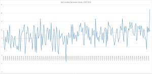
December 2015 was a ridiculously warm month, the mildest on record in my local series going back to 1797.Top 10 warmest Dec means

The mean temperature of 10.9C is 5.3C above the average for the first winter month and breaks the previous record set in 1974 by an increadible 2.2C.

Indeed the month was warmer than what was a very mild November and was air frost free.

sahara
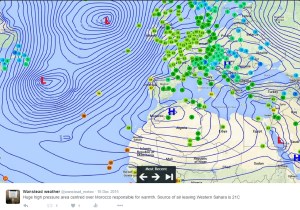
A persistent flow of air from the Azores was responsible for the unseasonal warmth

Sunshine was below average: 34.6hrs (86% of average) was the lowest total recorded since 2010, another December that was as exceptionally cold as this month was mild.

Rainfall was more run-of-the-mill: 44mm fell during the month: that’s 83% of average.

The warmest day occurred on the 19th with 16.3C recorded, the second warmest December day in my daily record going back to 1959 – the record fell short by just 0.1C.

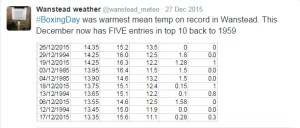
warmest xmas daysOther daily records were broken including for daily mean temperature: 14.3C on Boxing Day smashed the previous record set on December 4th 1985 by 0.4C. This day also saw the highest daily minimum for December recorded: 13.5C. It was also the warmest Christmas Day on record in a series going back beyond 1852.

decrainThe lowest temperature occurred on the 8th when the mercury fell to 2.4C.
The wettest day was on the 3oth when 5.9mm of rain fell. There were only three completely dry days during the month. Thanks to the synoptic situation this area thankfully escaped the awful flooding which affected the north of England and Scotland.

december mean 1797-2015
There is quite a marked upward trend in the December mean since 1797

What has January got in store weatherwise? The models today (January 1st) suggest that low pressure will continue to pile into the UK from the west on quite southerly latitudes over the next week with some colder air infiltrating into the east and north of the UK from Europe with rain at times for our area. From that point on most output suggests largely unsettled weather continuing until the end of the two week period though there is a hint that high pressure may try to edge up from the SW or west later with less wind and rain but still mild.

Because of the exceptionally mild December there are virtually no figures I can work with to try to estimate January – but I’ll have a crack anyway, using figures that were at least 1C above the 1981-2010 December average.

A mean of about 5.2C with 59mm of rain, both around average. The highest probability is for average temps at 33% probability. Interestingly something ‘very cold’ comes in at the same probability. Rather mild and rather cold come in at 16% probability. I emphasise that even at such low probability my confidence is even lower.

My December outlook for temperature was way off – there was no chance shown of anything ‘very mild’.

Here follows the full weather diary for November. To view full stats follow this link:http://1drv.ms/1kiTuzv

1st: A few spots of rain after deluge overnight then cloudy.
2nd: Cloudy to start, some sun mid morning before it clouded over with two spots of rain. Mild overnight.
3rd: Cloudy start with little brightness all day. Rain moving in at 7.15pm and intermittent into the evening, clearing later with temp falling from midnight.
4th: Sunny, clear start, tending to cloud over at 11am with limited brightness.
5th Cloudy and windy all day – the wind peaking at 9pm but remaining fresh through the night.
6th: Cloudy and dull most of the day.
7th: Cloudy start with some light drizzle mid morning.
8th: Dull, drizzly start with steadier bursts. Heavy rain as front cleared through at 2pm. Evening and overnight much colder than of late.
9th: Sunny start, clouded over afternoon.
10th Cloudy start and through the day. Rain spreading in in the evening, clearing by midnight.
11th: Cloudy through the day until 2pm when a narrow band of rain passed through then dry and feeling cooler.
12th: Cloudy start with some drizzle around 10am.
13th: Cloudy and drizzly to start then just cloudy.
14th: Cloudy start with some brightness at noon. Cloudy into the afternoon with some drizzle overnight.
15th: Cloudy and dull. Rain later in the evening.
16th: Cloudy with two sunny intervals then cloudy with odd drizzle.
17th: Cloudy with odd brightness then rain at 5pm.
18th: Cloudy all day.
19th: Bright and breezy start.
20th: Dull start with heavy rain at 3.40pm. Then cloudy but clear by morning.
21st: Sunny start but quickly clouded over with rain.
22nd: Dull start with patchy drizzle up to 11.30am. More rain later with squall at 8pm.
23rd: Sunny start with cloud moving in then sunny spells.
24th: Sunny start quickly turned cloudy with heavy rain around noon, clearing to sunny spells.
25th: Cloudy start with light rain spreading in at 10.10am. Cloudy rest of afternoon with temperature climbing through the day for record warm Christmas day. Temp didn’t fall below 14C all night.
26th: Cloudy and warm all day. Temp fell to just 13.9C though the day then rose again to give the warmest December night on record, and also warmest December mean.
27th: Dull with brief burst of drizzle early then breezy and very mild. Clearer overnight and cooler than of late. Sunny start with pink clouds am.
28th: Sunny start with just a few cirrus. Mostly sunny through the day.
29th: Sunny start with brief heavy shower at 10.05am. Then sunny intervals.
30th Cloudy and breezy to start. Rain spreading in in the evening, stopping around midnight
31st: Sunny and clear to start but with cloud bubbling up from late morning. Brief rain after dark then dry and turning colder. Frost in early hours of 1st

The GFS countdown to Christmas Day

xmas2412
The op chart for Christmas Day on 24/12 shows the UK split between influence from a low to the north of Scotland and a European high giving a balmy SW’ly . Rain moves up from the SW during the day. Temps in London rising to 13C after a low of 4C. Best chance of anything wintry northern Scotland

The odds for snow on Christmas Day have been shortened for those that live in northern Scotland, reflecting the latest operational model runs that suggest the current mild regime will continue in the south.


The operational runs of the weather model GFS began to include Christmas Day in its forecast on December 9. Admittedly T+384 is la-la land in terms of trying to accurately predict what the weather will be like on the day but I thought it would be fun to see how the outcome changes over the next two weeks or so.

William Hill odds for snow on Christmas Day:
9th: London 5/1; Aberdeen 5/2; Edinburgh 3/1; Glasgow 3/1; Newcastle 4/1; Belfast 5/1;  Birmingham 6/1; Norwich Airport 7/1; Penzance 10/1
10th: unchanged. 11th: unchanged. 12th: unchanged. 13th: unchanged. 14th: unchanged. 15th: unchanged. 16th: London 8/1; Aberdeen 7/2; Edinburgh 4/1; Glasgow 4/1; Newcastle 5/1; Belfast 5/1;  Birmingham 7/1; Norwich Airport 10/1; Penzance 16/1.

22nd: London 12/1; Aberdeen 5/2; Edinburgh 7/2; Glasgow 7/4; Newcastle 5/1; Belfast 10/3;  Birmingham 10/1; Norwich Airport 10/1; Penzance 12/1.

23rd: London 18/1; Aberdeen 5/2; Edinburgh 7/2; Glasgow 7/4; Newcastle 5/1; Belfast 10/3;  Birmingham 10/1; Norwich Airport 10/1; Penzance 16/1.

My predicted outcome for London made at the beginning of December:  TMax: 7C  TMin: 1C Moderate westerly 60% chance of rain shower 1hr of sunshine

  • Please note that the outcome will change markedly from run to run, day to day. The best hint of what the weather will be like will be from T=240z (10 days) and, reliably, T+120z. If the pattern is zonal then detail can only start being pinned down at T+72z.|
xmas091206z
5C, variable winds with threat of rain approaching from south-west. Chance of wintry showers Liverpool northwards. Snow On Christmas Day 5/2 Aberdeen Airport 3/1 Edinburgh Airport 3/1 Glasgow Airport 4/1 Newcastle Airport 5/1 Belfast Int. Airport 5/1 Leeds Bradford Airport 5/1 Liverpool Airport 5/1 London Heathrow 6/1 Birmingham Airport 6/1 Dublin Airport 6/1 Manchester Airport 7/1 Bristol Airport 7/1 Cardiff Airport 7/1 Norwich Airport 10/1 Penzance RNAS Culdrose
xmas1012
The operational chart for Christmas Day on 10/12 shows ridging from the south allowing a brief spell of quiet weather. Temps in London a couple of degrees above freezing with frost at night. A flurry possible almost anywhere though east coast most likely.
xmas1112500mb
The op chart for Christmas Day on 11/12 shows a ridge bringing a brief spell of cold, quiet weather. Temps in London about 6C after a cold, possibly frosty start. Dry to start though increased risk of rain from the west later. Best chance for anything sleety probably Glasgow…
xmas1212
The op chart for Christmas Day on 12/12 shows the UK in a col. Rain a possibility almost anywhere but chiefly in the SW and south. Temps in London about 6C and a low of 3C. Best chance for anything wintry probably Aberdeen toward midnight…
xmas1312
The op chart for Christmas Day on 13/12 shows the UK in a returning N’ly regime. Heavy rain spreading in to SW and S. Temps in London about 12C and a low of 6C. Best chance for anything wintry in the far north
xmas1412
The op chart for Christmas Day on 14/12 shows the UK in a returning N’ly regime. Starting dry in the SE but rain spreading in later. Temps in London peaking at 13C after a low of 10C. Best chance for anything wintry in the far north
xmas1512
The op chart for Christmas Day on 15/12 shows the UK split between a returning N’ly regime and a large area of high pressure centred over Switzerland, advecting warm air from North Africa. Mostly dry across the UK with best chance of precipitation NW Scotland. Temps in London peaking at 10C after a low of 7C. No chance of anything wintry, anywhere
xmas1612
The op chart for Christmas Day on 16/12 shows the UK split between a returning N’ly regime and a large area of high pressure over central Europe, advecting warm air from North Africa. A band of rain lies across the UK though dry in the SE. Temps in London peaking at 13C after a low of 11C. No chance of anything wintry, anywhere
xmas1712
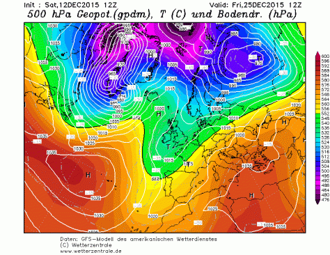
The op chart for Christmas Day on 17/12 shows most of the UK in a balmy SW’ly regime, controlled by a strong high pressure over central Europe. Air over the SE is all the way from the Sahara. Any precipitation confined to Scotland. Temps in London peaking at 11C after a low of 8C. No chance of anything wintry, anywhere
xmas1812
The op chart for Christmas Day on 18/12 shows the UK split between influence from a low centred over Iceland and a European high giving a balmy SW’ly . Air over the SE is from northern Spain. A band of rain heralds cooler air from the NW. Temps in London peaking at 11C and falling away during the day. Best chance of anything wintry Western Isles of Scotland
xmas1912
The op chart for Christmas Day on 19/12 shows the UK split between low centred off north of Scotland introducing a cooler NW’ly airstream while south just about hangs on to the European high. A band of rain clears SE early on 25th from the NW. Temps in London peaking at 10C and falling away during the day. Best chance of anything wintry high ground in N England and northern Scotland
xmas2012
The op chart for Christmas Day on 20/12 shows the UK split between influence from a low to the north of Scotland and and a European high giving a balmy SW’ly . Rain moves in from the west during the day. Temps in London rising to 12 after a low of 4C. Best chance of anything wintry northern Scotland
xmas2112
The op chart for Christmas Day on 21/12 shows the UK split between influence from a low to the north of Scotland and and a European high giving a balmy SW’ly . Rain moves in from the west during the day. Temps in London rising to 12 after a low of 4C. Best chance of anything wintry northern Scotland
xmas2212
The op chart for Christmas Day on 22/12 shows the UK split between influence from a low to the north of Scotland and a European high giving a balmy SW’ly . Rain moves up from the SW during the day. Temps in London rising to 13C after a low of 4C. Best chance of anything wintry northern Scotland
xmas2212
The op chart for Christmas Day on 22/12 shows the UK split between influence from a low to the north of Scotland and a European high giving a balmy SW’ly . Rain moves up from the SW during the day. Temps in London rising to 13C after a low of 4C. Best chance of anything wintry northern Scotland
xmas2312
The op chart for Christmas Day on 23/12 shows the UK split between influence from a low to the north of Scotland and a European high giving a balmy SW’ly . Rain moves up from the SW during the day. Temps in London rising to 13C after a low of 4C. Best chance of anything wintry northern Scotland

This slideshow requires JavaScript.


Blitz bombs bring more terror to Woodford

The run up to Christmas 85 years ago saw yet more terror in the form of Luftwaffe bombs falling on an already shellshocked population in east London.

The final raid of the year, on the evening of December 8th, saw yet more tragedy befall the borough of Woodford.

Just after 7pm a high explosive bomb fell in St Albans Road, killing three people. And at 10.25pm a paramine was dropped on Wordsworth Avenue, South Woodford, killing 14 people and injuring 41.

It was the second deadliest day of the Blitz for the two boroughs which had already endured three months of bombing raids that had left 27 dead and over 100 injured.

The weather was fairly typical for early December, some winter sunshine with a high of 6C followed by a minimum of 2C. Really cold weather didn’t arrive until much later in the month.

Over a period of eight months around 450 bombs were dropped on the two boroughs, killing 129 people and injuring 194.

From autumn to spring in December 1806

When I was writing up my winter forecast I came across an analogue that was very similar to what happened during the period November 10th to December 31st.

mean 1806 v 2015
The period November 10th – December 31st in 1806 and 2015 show some striking similarities. It is also notable that mean during 2015 was 3C higher than 1806. Is this a question of synoptics or a warming world?


The results showed a close similarity between the two periods, November 10th – December 31st, though the mean in 2015 was some 3C warmer than 1806. Is this a question of synoptics or is this area now 3C warmer than it was just over 200 years ago?

Rainfall was also remarkably similar: 87.7mm fell from 10/10 – 31/12, just over 5mm more than 1806.

rain 1806 v 2015
The period November 10th – December 31st in 1806 and 2015 show some striking similarities. It is also notable that mean during 2015 was 3C higher than 1806. Is this a question of synoptics or a warming world?

Luke Howard, in his first volume of The Climate of London, describes a very warm December that followed on from a warm November that fooled flora and fauna into thinking spring had begun early.

Howard’s statistics are very high: a November mean of 9.5C while December was 7.2C. CET that November was 2.3C above average while December was 3.3C above average. Considering the England Wales Precipitation series a slightly wetter than average November was followed by a very wet December – over 250% the monthly average.

“The catkins of the filberts expanded prematurely. On December 25th a hedge sparrow’s nest was taken at Doveridge, Derbyshire, with four eggs and near Warwick a green linnet’s with two eggs. It is worthy of remark that the heat was the same on December 24th as on June 24th last – on both those days the thermometer being nearly 60F.”

Howard goes on to describe how the south-west wind had “reigned for weeks” – for most of November and December before finally giving way at the turn of the year.

“The south west wind which had so long reigned yielded just at the close of the year to the north and west . Some frost ensued which, however, had not the characters of permanence being neither ushered in by driven snows nor accompanied with a dry and serene atmosphere.”

The River Lea close to where Luke Howard's laboratory stood by wanstead_meteo
The period November 10th – December 31st in 1806 and 2015 show some striking similarities. It is also notable that mean during 2015 was 3C higher than 1806. Is this a question of synoptics or a warming world?

His description is not dissimilar from what is known as a “three-day toppler” cold spell where a dominant European high briefly gives way to cold air from the north-west or north, bringing often heavy snow to Scotland and the north but just a few cooler days in the south, before the cold feed is cut off as the high re-establishes itself.

Howard also describes how the warmth affected plants.

“The effects of the late high winter temperature on vegetation must have been obvious to everyone who has seen the country. To the very close of the year the grass continued to grow, the daisies to enamel the turf and many of the inmates of our gardens native and exotic to thrive and blossom. Even hyacinth bulbs left in the open beds shot up and flowered. Ten years ago winter came on six weeks earlier and with considerable severity.”

Words that echo what’s going on this month, particularly in the south-west where I’ve heard reports of roses still in bloom and affected by greenfly whiles daffodils look like they will be out in a couple of days.

January and February 1807 were, by the standards of that time, roughly average.