The op chart for Christmas Day on 24/12 shows the UK split between influence from a low to the north of Scotland and a European high giving a balmy SW’ly . Rain moves up from the SW during the day. Temps in London rising to 13C after a low of 4C. Best chance of anything wintry northern Scotland
The odds for snow on Christmas Day have been shortened for those that live in northern Scotland, reflecting the latest operational model runs that suggest the current mild regime will continue in the south.
The operational runs of the weather model GFS began to include Christmas Day in its forecast on December 9. Admittedly T+384 is la-la land in terms of trying to accurately predict what the weather will be like on the day but I thought it would be fun to see how the outcome changes over the next two weeks or so.
William Hill odds for snow on Christmas Day:
9th: London 5/1; Aberdeen 5/2; Edinburgh 3/1; Glasgow 3/1; Newcastle 4/1; Belfast 5/1; Birmingham 6/1; Norwich Airport 7/1; Penzance 10/1
10th: unchanged. 11th: unchanged. 12th: unchanged. 13th: unchanged. 14th: unchanged. 15th: unchanged. 16th: London 8/1; Aberdeen 7/2; Edinburgh 4/1; Glasgow 4/1; Newcastle 5/1; Belfast 5/1; Birmingham 7/1; Norwich Airport 10/1; Penzance 16/1.
My predicted outcome for London made at the beginning of December: TMax: 7C TMin: 1C Moderate westerly 60% chance of rain shower 1hr of sunshine
Please note that the outcome will change markedly from run to run, day to day. The best hint of what the weather will be like will be from T=240z (10 days) and, reliably, T+120z. If the pattern is zonal then detail can only start being pinned down at T+72z.|
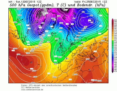
5C, variable winds with threat of rain approaching from south-west. Chance of wintry showers Liverpool northwards. Snow On Christmas Day 5/2 Aberdeen Airport 3/1 Edinburgh Airport 3/1 Glasgow Airport 4/1 Newcastle Airport 5/1 Belfast Int. Airport 5/1 Leeds Bradford Airport 5/1 Liverpool Airport 5/1 London Heathrow 6/1 Birmingham Airport 6/1 Dublin Airport 6/1 Manchester Airport 7/1 Bristol Airport 7/1 Cardiff Airport 7/1 Norwich Airport 10/1 Penzance RNAS CuldroseThe operational chart for Christmas Day on 10/12 shows ridging from the south allowing a brief spell of quiet weather. Temps in London a couple of degrees above freezing with frost at night. A flurry possible almost anywhere though east coast most likely.The op chart for Christmas Day on 11/12 shows a ridge bringing a brief spell of cold, quiet weather. Temps in London about 6C after a cold, possibly frosty start. Dry to start though increased risk of rain from the west later. Best chance for anything sleety probably Glasgow…The op chart for Christmas Day on 12/12 shows the UK in a col. Rain a possibility almost anywhere but chiefly in the SW and south. Temps in London about 6C and a low of 3C. Best chance for anything wintry probably Aberdeen toward midnight…The op chart for Christmas Day on 13/12 shows the UK in a returning N’ly regime. Heavy rain spreading in to SW and S. Temps in London about 12C and a low of 6C. Best chance for anything wintry in the far northThe op chart for Christmas Day on 14/12 shows the UK in a returning N’ly regime. Starting dry in the SE but rain spreading in later. Temps in London peaking at 13C after a low of 10C. Best chance for anything wintry in the far northThe op chart for Christmas Day on 15/12 shows the UK split between a returning N’ly regime and a large area of high pressure centred over Switzerland, advecting warm air from North Africa. Mostly dry across the UK with best chance of precipitation NW Scotland. Temps in London peaking at 10C after a low of 7C. No chance of anything wintry, anywhereThe op chart for Christmas Day on 16/12 shows the UK split between a returning N’ly regime and a large area of high pressure over central Europe, advecting warm air from North Africa. A band of rain lies across the UK though dry in the SE. Temps in London peaking at 13C after a low of 11C. No chance of anything wintry, anywhereThe op chart for Christmas Day on 17/12 shows most of the UK in a balmy SW’ly regime, controlled by a strong high pressure over central Europe. Air over the SE is all the way from the Sahara. Any precipitation confined to Scotland. Temps in London peaking at 11C after a low of 8C. No chance of anything wintry, anywhereThe op chart for Christmas Day on 18/12 shows the UK split between influence from a low centred over Iceland and a European high giving a balmy SW’ly . Air over the SE is from northern Spain. A band of rain heralds cooler air from the NW. Temps in London peaking at 11C and falling away during the day. Best chance of anything wintry Western Isles of ScotlandThe op chart for Christmas Day on 19/12 shows the UK split between low centred off north of Scotland introducing a cooler NW’ly airstream while south just about hangs on to the European high. A band of rain clears SE early on 25th from the NW. Temps in London peaking at 10C and falling away during the day. Best chance of anything wintry high ground in N England and northern ScotlandThe op chart for Christmas Day on 20/12 shows the UK split between influence from a low to the north of Scotland and and a European high giving a balmy SW’ly . Rain moves in from the west during the day. Temps in London rising to 12 after a low of 4C. Best chance of anything wintry northern ScotlandThe op chart for Christmas Day on 21/12 shows the UK split between influence from a low to the north of Scotland and and a European high giving a balmy SW’ly . Rain moves in from the west during the day. Temps in London rising to 12 after a low of 4C. Best chance of anything wintry northern ScotlandThe op chart for Christmas Day on 22/12 shows the UK split between influence from a low to the north of Scotland and a European high giving a balmy SW’ly . Rain moves up from the SW during the day. Temps in London rising to 13C after a low of 4C. Best chance of anything wintry northern ScotlandThe op chart for Christmas Day on 22/12 shows the UK split between influence from a low to the north of Scotland and a European high giving a balmy SW’ly . Rain moves up from the SW during the day. Temps in London rising to 13C after a low of 4C. Best chance of anything wintry northern ScotlandThe op chart for Christmas Day on 23/12 shows the UK split between influence from a low to the north of Scotland and a European high giving a balmy SW’ly . Rain moves up from the SW during the day. Temps in London rising to 13C after a low of 4C. Best chance of anything wintry northern Scotland


You must be logged in to post a comment.