I took this short video during approach and landing at Alexandros Papadiamantis airport, Skiathos, in August 2016.
As you can see the weather was sunny, around 32C with light winds. Because of the short runway if the weather is less than perfect airliners sometimes get diverted to the mainland, necessitating a ferry crossing – though, in four years of visiting, I’ve only had one unscheduled stop on departure – if the plane is full the aircraft can only be partly filled with fuel.
The spectacle of jets landing has also become a must do for tourists who stand at the end of the runway waiting to get blasted during close encounters with landing aircraft.
It’s a beautiful island in the Sporades and was where, along with Skopelos, provided the backdrop to the film Mamma Mia! Because it is very green I’ve found it doesn’t get overly hot like other parts of Greece.
Indeed, in all the years we’ve visited there has always been one stormy day before the weather clears again.
Weather models are hinting that this coming bank holiday weekend could be very warm indeed, with one WX Charts animation suggesting that a positive anomaly of 12C could be possible on Monday.
A date record looks a formality and, unless there’s a downgrade, new monthly high temperature records at stations across the south-east look a possibility.
While it looks very warm it is too early to start talking about heatwaves. And, considering the pattern since late February, with hot and cold alternating weekly, a brief return to much cooler conditions at the beginning of June can’t be ruled out.
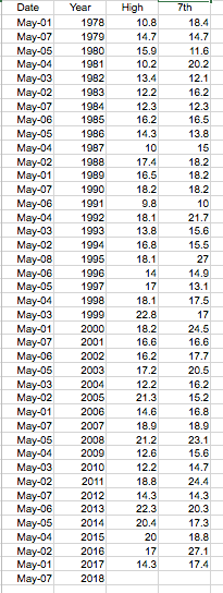
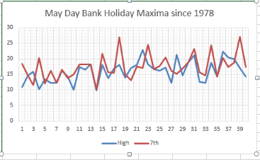
The British record high temperature for May is 32.8C, reached on two occasions:
Camden Square, London May 22nd 1922. The same station recorded this value again on May 29th 1944, along with Regents Park, Horsham and Tunbridge Wells.
The national date record for the 28th, according to TORRO, is 30.6C at Camden Square.
Locally the highest temperature recorded in this area in May is 32.1C on May 27th 2005. The date record I recorded is 26.5C in 2012.
The media are up to their old tricks of flagging up their usual ‘hottest ever’ line; this time the May Day bank holiday.
Today’s Guardian
Today’s Guardian informs readers that Monday could be the warmest ever May Day bank holiday, the quite unremarkable record high of 23.9C was set in 1999.
A closer look, however, reveals that dates of the holiday, which only began in 1978, are always moving. Like Easter the date shifts and can fall on any day between the 1st to the 8th. Only six early May bank holidays have occurred on the 7th. It is therefore difficult to compare like with like.
A more correct approach is to compare date records which, for the 7th since 1978, the highest is 27.1C in 2016. The highest temperature for the 7th going back 60 years is 28.5C in 1976.
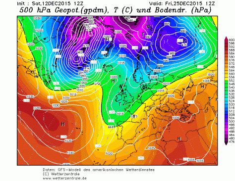
The op chart for Christmas Day on 24/12 shows the UK split between influence from a low to the north of Scotland and a European high giving a balmy SW’ly . Rain moves up from the SW during the day. Temps in London rising to 13C after a low of 4C. Best chance of anything wintry northern Scotland
The odds for snow on Christmas Day have been shortened for those that live in northern Scotland, reflecting the latest operational model runs that suggest the current mild regime will continue in the south.
The operational runs of the weather model GFS began to include Christmas Day in its forecast on December 9. Admittedly T+384 is la-la land in terms of trying to accurately predict what the weather will be like on the day but I thought it would be fun to see how the outcome changes over the next two weeks or so.
William Hill odds for snow on Christmas Day:
9th: London 5/1; Aberdeen 5/2; Edinburgh 3/1; Glasgow 3/1; Newcastle 4/1; Belfast 5/1; Birmingham 6/1; Norwich Airport 7/1; Penzance 10/1
10th: unchanged. 11th: unchanged. 12th: unchanged. 13th: unchanged. 14th: unchanged. 15th: unchanged. 16th: London 8/1; Aberdeen 7/2; Edinburgh 4/1; Glasgow 4/1; Newcastle 5/1; Belfast 5/1; Birmingham 7/1; Norwich Airport 10/1; Penzance 16/1.
My predicted outcome for London made at the beginning of December: TMax: 7C TMin: 1C Moderate westerly 60% chance of rain shower 1hr of sunshine
Please note that the outcome will change markedly from run to run, day to day. The best hint of what the weather will be like will be from T=240z (10 days) and, reliably, T+120z. If the pattern is zonal then detail can only start being pinned down at T+72z.|
5C, variable winds with threat of rain approaching from south-west. Chance of wintry showers Liverpool northwards. Snow On Christmas Day 5/2 Aberdeen Airport 3/1 Edinburgh Airport 3/1 Glasgow Airport 4/1 Newcastle Airport 5/1 Belfast Int. Airport 5/1 Leeds Bradford Airport 5/1 Liverpool Airport 5/1 London Heathrow 6/1 Birmingham Airport 6/1 Dublin Airport 6/1 Manchester Airport 7/1 Bristol Airport 7/1 Cardiff Airport 7/1 Norwich Airport 10/1 Penzance RNAS CuldroseThe operational chart for Christmas Day on 10/12 shows ridging from the south allowing a brief spell of quiet weather. Temps in London a couple of degrees above freezing with frost at night. A flurry possible almost anywhere though east coast most likely.The op chart for Christmas Day on 11/12 shows a ridge bringing a brief spell of cold, quiet weather. Temps in London about 6C after a cold, possibly frosty start. Dry to start though increased risk of rain from the west later. Best chance for anything sleety probably Glasgow…The op chart for Christmas Day on 12/12 shows the UK in a col. Rain a possibility almost anywhere but chiefly in the SW and south. Temps in London about 6C and a low of 3C. Best chance for anything wintry probably Aberdeen toward midnight…The op chart for Christmas Day on 13/12 shows the UK in a returning N’ly regime. Heavy rain spreading in to SW and S. Temps in London about 12C and a low of 6C. Best chance for anything wintry in the far northThe op chart for Christmas Day on 14/12 shows the UK in a returning N’ly regime. Starting dry in the SE but rain spreading in later. Temps in London peaking at 13C after a low of 10C. Best chance for anything wintry in the far northThe op chart for Christmas Day on 15/12 shows the UK split between a returning N’ly regime and a large area of high pressure centred over Switzerland, advecting warm air from North Africa. Mostly dry across the UK with best chance of precipitation NW Scotland. Temps in London peaking at 10C after a low of 7C. No chance of anything wintry, anywhereThe op chart for Christmas Day on 16/12 shows the UK split between a returning N’ly regime and a large area of high pressure over central Europe, advecting warm air from North Africa. A band of rain lies across the UK though dry in the SE. Temps in London peaking at 13C after a low of 11C. No chance of anything wintry, anywhereThe op chart for Christmas Day on 17/12 shows most of the UK in a balmy SW’ly regime, controlled by a strong high pressure over central Europe. Air over the SE is all the way from the Sahara. Any precipitation confined to Scotland. Temps in London peaking at 11C after a low of 8C. No chance of anything wintry, anywhereThe op chart for Christmas Day on 18/12 shows the UK split between influence from a low centred over Iceland and a European high giving a balmy SW’ly . Air over the SE is from northern Spain. A band of rain heralds cooler air from the NW. Temps in London peaking at 11C and falling away during the day. Best chance of anything wintry Western Isles of ScotlandThe op chart for Christmas Day on 19/12 shows the UK split between low centred off north of Scotland introducing a cooler NW’ly airstream while south just about hangs on to the European high. A band of rain clears SE early on 25th from the NW. Temps in London peaking at 10C and falling away during the day. Best chance of anything wintry high ground in N England and northern ScotlandThe op chart for Christmas Day on 20/12 shows the UK split between influence from a low to the north of Scotland and and a European high giving a balmy SW’ly . Rain moves in from the west during the day. Temps in London rising to 12 after a low of 4C. Best chance of anything wintry northern ScotlandThe op chart for Christmas Day on 21/12 shows the UK split between influence from a low to the north of Scotland and and a European high giving a balmy SW’ly . Rain moves in from the west during the day. Temps in London rising to 12 after a low of 4C. Best chance of anything wintry northern ScotlandThe op chart for Christmas Day on 22/12 shows the UK split between influence from a low to the north of Scotland and a European high giving a balmy SW’ly . Rain moves up from the SW during the day. Temps in London rising to 13C after a low of 4C. Best chance of anything wintry northern ScotlandThe op chart for Christmas Day on 22/12 shows the UK split between influence from a low to the north of Scotland and a European high giving a balmy SW’ly . Rain moves up from the SW during the day. Temps in London rising to 13C after a low of 4C. Best chance of anything wintry northern ScotlandThe op chart for Christmas Day on 23/12 shows the UK split between influence from a low to the north of Scotland and a European high giving a balmy SW’ly . Rain moves up from the SW during the day. Temps in London rising to 13C after a low of 4C. Best chance of anything wintry northern Scotland
Thunderstorms and prolonged heavy rain aren’t what you usually associate with the Aegean in August. So to experience three days in a row of inclement weather must be rare in this beautiful part of Europe.
Water from the hills above turned local roads into rivers
Arriving at the end of a heatwave the owner of my hotel in Skiathos remarked that humidity had been particularly high though temperatures had cooled from the previous week’s level of 36C – not bad in itself but when you consider the low fell to just 27.1C those sorts of values make it impossible to sleep without air conditioning.
Sunshine on the first couple of days came to an abrupt end on the Friday night with the arrival of the first disturbance – the sound of thunder and torrential rain audible above the low buzz of the air conditioning. The storm gradually cleared in the morning to leave sunny spells by the afternoon.
This process repeated itself over the next couple of days although by the third night only heavy rain developed. Since returning to the UK I’ve had a look at statistics from a weather station located on the north of the island near Kastro. Rain totals on August 21st, 22nd and 23rd were 36.2mm, 39.2mm and 34mm respectively – bringing the total for the month to 113mm, nearly three times what fell last August. Looking at national Greek totals on Ogimet the disturbance was very localised.
Torrents of water from the storms caused deep scars in the landscape. I spotted this at the edge of an olive grove during a walk through a forest to Mandraki
The torrents of rain carved deep gorges in the paths that criss-cross the island. And during a walk from Koukounaries to Madraki part of the impacted sand/soil road down to the beach had been washed away.
Locals didn’t seem that phased by it and judging by the number of tavernas with wind down sides to their awnings it is perhaps a common feature of the climate?
Mean temperature for August was 0.3C up on last year: 27C, though the number of days of >32C was nearly half last year.
The island, part of the Sporades, is famous for being the location where the hit musical Mamma Mia was filmed – though most filming was done on neighbouring Skopelos. It’s a very green area – much more so than southern islands I’ve visited such as Ios and Crete which are arid by comparison.
During a visit to Skopelos, which has a landscape that looks almost Alpine from a distance with its pine forested hills, I was puzzled by the lack of wind turbines, especially considering how reliable wind seems to be in the surrounding waters.
One of the many stunning beaches on Skiathos. This bay is close to Mandraki
Greece does have an extensive wind power programme though much of it is based in the mountains in the north. EU politics over energy tariffs also probably play a part.
Thunderstorms also played a part on our flight home. As we crossed the mountains of Macedonia and the Balkans to the north I could see vast cumulonimbus begin to form. The pilot made an excellent job of keeping turbulence to a minimum by steering us around these forces of nature – a couple of which reached above our cruising altitude of 39,000ft.
* Storms also affected Skiathos and Skopelos in September. A weather station on Skopelos reported 209.6 mm on 22nd September, with an additional 56.2mm on the day before and 49.2mm the day after. The month there has abundantly given 317mm, but this is *not* the wettest area of Greece for September so far. The very warm seas at this time of the year have given numerous places a lot of precipitation, backed up, of course, by great support aloft .
The storm caused much damaged and devastation to infrastructure in the towns in Skopelos.
The island of Skopelos is even more stunning than SkiathosMuch convective development could be seen during the flight home as we crossed Macedonia and the Balkan mountains to the northThe pilot made a good job of steering round the storms. It made a change to see these marvels of nature from above – though some still developed higher than our 39,000ft cruising altitudeIn a shop close to Koukounaries beach I noticed this selection of snowy pictures that were taken on the island a few years ago. Being north of Athens it is not surprising that they occasionally see snow here


You must be logged in to post a comment.