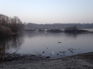
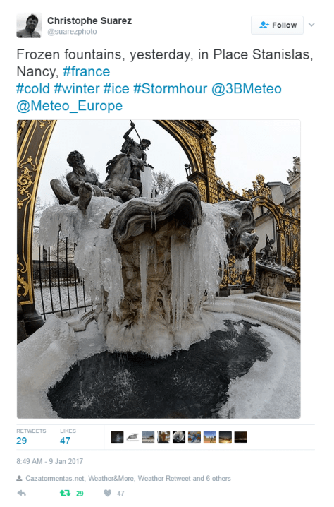
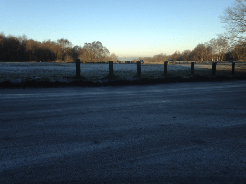
There was much talk yesterday about a lot of the south of the England recording an ‘ice day’.
In the London area most places missed out because the temperature rose briefly above freezing around dusk and also just before the 0900 observation today.
So although it felt brass monkeys out there it doesn’t count.
Ice days are when the temperature fails to rise above -0.1C over a 24 hour period, usually from 0900 to 0900. The confusion over yesterday’s ice day was caused by the fact that some stations release a 06-18 maximum reading – both Kenley and Shoebury stayed below zero in this time period.
Ice days in the Wanstead area are probably even rarer than decent snowfalls. Since 1959 there have been 81 ice days.
The last time the temperature failed to rise above 0.0C was January 20th 2013. The last time the temperature failed to rise above -0.1C (a true ice day) was January 6th 2010.
Over a dozen stations stayed below freezing for 24hrs to 09z on January 27th
Stephen Davenport’s synoptic analysis of the event is included below:
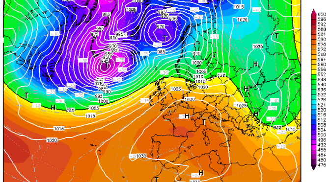
“[The cold conditions were] all thanks to this nicely (or not nicely, depending on your view) blocked situation. On Tuesday 24th a 500 hPa ridge started build northeastwards to the north of a small upper low situated over France. By 12z on Wednesday 25th it had cut off to leave a classic-looking Rex block over western Europe:
Surface winds from the Continent started to bring colder air across as the temperature anomaly analysis for 12z Wed 25th shows, while milder southerlies continued across Ireland and Scotland, and brushed western Wales and SW England:
By 12z Thursday 26th the block was becoming more omega-like…
… and cold air continued to percolate north-westwards from the Continent farther across the British Isles:
There’s a certain beauty in the sinusoidal flow around a Rex block, I always think.”
December 2016 was the driest 12th month in over 80 years and the 5th driest in a record going back to 1797.
Christmas day was the second warmest on record in London
The total fall of 8.3mm is just 16 per cent of what normally falls in December, marginally more than December 1933. The mean temperature of 6.1C was 0.5C above average, though 4C colder than the record December last year.
There were 51hrs of sunshine, that’s 125 per cent of average.
The wettest day was on the 10th when 5.2mm of rain fell. The warmest day occurred on the 9th with 14.2C recorded. The lowest temperature occurred on the 28th when the spirit fell to -4C.
The sunniest days were on the 4th and 29th when seven hours of sunshine were recorded.
Air frosts: 8, Ground frosts: 14
Fog, frost and black ice all featured during December
Though January has started on the chilly side in the short term the weather will turn mild. Beyond that there is a suggestion that the weather could turn on the colder side of average with some models suggesting a cold snap with snow around mid-month.
My usual method of prediction to the end of the month has been scotched by the very dry December. The only years that were similar were both far colder than last month – the usual pattern of a dry month being cold or very cold was broken.
With the unprecedented warmth at the North Pole, last year’s odd behaviour of the QBO and a weak polar vortex we are in unprecedented territory in terms of what could happen later in January. My hunch, though, suggests the month will end up average to rather cold with little precipitation. Any cold spell with probably be the short-lived variety with a couple of inches of snow that lasts three days.
So, to sum up, we’re looking at a mean of 4.4C, rainfall: 55mm, sunshine: 39hrs.
In view of the above my forecast last month was very poor: predicted mean 4.4C (result 6.1C). Rainfall: 55mm (result 8mm). Sunshine: 39hrs (result 51hrs)
I have also published a winter forecast covering the London area that you can find here.
Here follows the full weather diary for December…Full stats for the month here:http://1drv.ms/1rSfT7Y
1st: Sunny start though the frost lifted readily into low cloud and mist to leave a chilly afternoon.
2nd: Cloudy, quiet and cool weather all day.
3rd: Cloudy and quiet all day. Feeling cold.
4th: Sunny , frosty start. Quickly warming up to leave sunny, cloudless afternoon.
5th: Sunny start, then patchy cloud – this thickening before becoming foggy overnight.
6th: Misty start after fog overnight. Cloudy most of the day though there was a brief clearance around midday.
7th: Cloudy most of the day though there was occasional brightness.
8th: Dull day though with a little limited brightness early afternoon.
9th: Cloudy but wth more brightness than yesterday. Very mild. Cloud thickened with light rain around 11am. This gradually grew heavier as the day progressed and was moderate overnight.
10th: Bright start and feeling mild, then cloudier and damp.
11th: Cloudy and dull all day.
12th: Dull all day with light rain early and late. Clearer spells overnight but overcast again by dawn.
13th: Dull with bits and pieces of drizzle up to 11.20am.
14th: Bright start with lots of cirrus and altocumulus – this gradually cleared to leave a warm and pleasant afternoon.
15th: Dull and cloudy with limited brightness.
16th: Dull and cloudy start.
17th: Foggy and dull all day.
18th: Misty start with fog above 90m on cycle ride. Then dull and grey all day. Mild.
19th: Dull and cloudy all day – some spots of drizzle.
2oth: Sunny start but clouded over late morning. Cloudy thereafter with some drizzle overnight.
21st: Cloudy start then sunny. Cloud returned and turned dull and dreary in the afternoon with odd drizzle.
22nd: Bright, misty start
23rd: Cloudy start with breeze beginning to build as a result of Storm Barbera.
24th: Cloudy and dull all day. Very mild. Temp increasing overnight with approach of warm front .
25th: Cloudy, breezy start. Remained dull all day though brightness was seen over the Thames and North Downs, disrupting the SW’ly flow.
26th: Sunny, hazy start and turning colder.
27th: Sunny, frosty start, the air pressure record of 2012 has been broken.
28th: Foggy start, the fog persisting to late morning before sun broke through leaving a chilly afternoon. Frost returned quickly after dark, a clear night.
29th: Sunny and very cold and frosty start. Frost returning after dark with fog forming in the early hours.
30th: Foggy and dull all day, the fog thickening up at nightfall. Approaching cloud lifted the fog and temperature.
31st: Dull and overcast to start – this sticking around all day.
I remember the January 1987 spell like it was yesterday. I’d arranged to stay with my aunt and uncle in a rural part of south Essex. The forecast by Ian McCaskill on the Friday night was for a cold weekend with possible snow flurries near the coast. ‘That’ll do’, I thought.
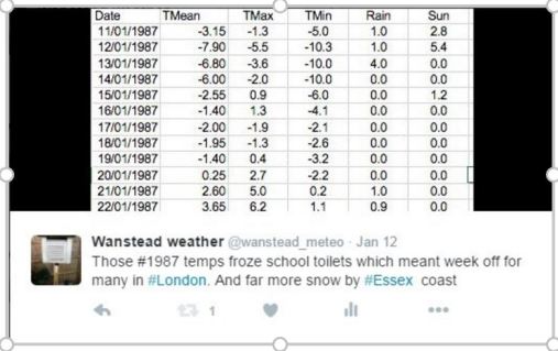
The upper air on 13th January 1987 was extremely cold. I don’t think it has been as cold since
I caught a mid-morning train from Romford on the Saturday morning. As I disembarked at Rayleigh I was shocked by how cold it seemed to have turned. The wait at the bus stop was made worse as my uncle was delayed in picking me up; a black leather jacket I was wearing at the time was totally inadequate.
No matter, though, as I was soon warmed up on reaching my aunt’s house, helped further by hearty home cooking. Saturday was spent driving round rural Essex: my uncle knew a few farmers and was a keen rambler. We walked a circuit around Hanningfield reservoir.
I think we watched Back to the Future that night. By the time I went to bed I remember there was a dusting of snow on the ground. For some reason I kept waking up, each time looking outside to see the build-up of snow.
There was around four inches by morning and, after breakfast, I went with my uncle for a drive around the same rural spots as Saturday. The reservoir was beginning to ice over and I remember my uncle reading a Fahrenheit thermometer and saying that it was “seven degrees of frost”.
When I left Rayleigh that evening the snow was falling thick and fast and the train seemed to be travelling slower than usual. When it failed to move from Shenfield station after 10 minutes I knew something was up; the guard announced that the wheels had frozen to the tracks. Everyone disembarked and caught another. After leaving Shenfield I noticed that the snow cover gradually decreased, with just an icing-sugar like covering in Romford.
My dismay at having left a winter wonderland in Rayleigh disappeared on waking up on the Monday morning and seeing a good few inches had fallen.
BBC Breakfast presenters gravely told us how bad things were. The Isle of Sheppey was cut off and train services were severely affected – I didn’t go to school once that week because the toilets were frozen. For once the conditions, reflected in this footage from Thames News, matched the hype.
East London: Ben Bacarisse was living in Mile End in 1987. He said: “I was living on the 15th floor of a tower block at the time. The prolonged cold caused the main water riser into the block to freeze so no one in nearly 400 flats (there were a pair of blocks) had running
water. It turned out to be possible to tap into the larger street main
with a stand-pipe.
Presumably the constant use kept it running though
I’d have thought it would have to be removed at night. I don’t recall
how long that lasted but it was more than a couple of days.”
Home Counties: George Booth, who was living in Epping, Essex, at the time, explained how the weather affected him: “On the Monday (12/1/87) I accompanied a group of young scholars to the Science Museum. Despite the cold and snow they were happy to walk to the station (and they behaved themselves). It was a strange sight to see
Exhibition Road covered in that thick brownish frozen dust which occurs
when temperatures are presumably too low for treatment to be effective.
Not so good news for the school roof, however. It eventually had to be
replaced after a water tank/pipe burst after a thaw.”
George, who ran a weather station in Epping, added: “On 12/1/87 the maximum temperature in Epping was -8.0c and the minimum was -10.0C. The ‘snow depth gradient’ was very steep NW-SE with SE Essex/E London and N Kent receiving much greater falls than places like Epping. However, it was the severe frost that caused many
problems, particularly in older buildings.”
Dave Cornwell, a retired scientist, from Laindon, Essex, said: “I was working as an operational scientist at a sewage treatment plant in Rainham , Essex. (London Borough of Havering, (just east of London). I remember it well because for the first time anyone could remember the sewage was freezing on entering the works through the screening bars, bearing in mind that sewage is flowing underground and starting off quite warm, usually in winter arriving at about 10-12C.
“It was a major engineering problem because the heat was being conducted away by the metal bars and ice building up and blocking the flow. This could potentially have caused backing up of millions of gallons of raw sewage. A smart engineer made some improvised electrical heaters to fit on the bars and we hired massive tarpaulins to put on the north side to try and cut down the wind chill. It worked a bit till the weather turned. I remember taking the temperature at 9.30 am and seem to recall it was -9.0C.”
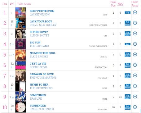
The record cold spell also saw Steve ‘Silk’ Hurley’s Jack Your Body enter the charts at Number 2, a track that more or less launched the UK dance music scene
John Hall, from Cranleigh, Surrey, said: “We had a little snow on the Monday, I think it was, but it didn’t amount to much. We had to wait for overnight Tuesday/Wednesday for serious snow, but then it certainly made up for lost time. On
Wednesday morning, the gritters must have done a remarkable job on the
roads, as traffic was moving – if slowly – on the B road that runs
through Cranleigh, and I was able to make the 8-mile journey to
Guildford Station.
“But at the station, a railwayman was standing by the entrance
telling everyone: ‘There are no trains. We don’t know when there will be
any trains. We advise you to go home.’ I managed to get a bus back to
Cranleigh, by which time the snow had just about stopped.
“I didn’t measure the depth of the snow, but my subjective impression that Wednesday morning was that it was almost a foot (30 cm) deep. The wind wasn’t strong enough to cause too much drifting that day, but the following day it became pretty strong, and there was considerable drifting of the powdery snow, with some susceptible local roads becoming blocked. In this southern lowland region I can’t remember another such instance of this ‘delayed drifting’.”
Tudor Hughes, had the added altitude (165m) of Warlingham, Surrey, that made the cold spell even more memorable. “It was just about the most outstanding weather event for me. The 12th was a sunny day with a light NE’ly and a few inches of lying snow and the temperature just wouldn’t rise.
“After a min of -12°C it got up to -9.2°C (12-hr max) which I think is a COL record though obviously not a UK one. The 24-hr max was -8.9°C, agreeing with the reading from Coulsdon (Ian Currie).
“In the evening some smoky-looking stratus appeared and snow fell from cloud so thin that the moon was visible. It snowed intermittently for a further 2 days until the level depth was 39 cm. At the top of the North Downs (Tatsfield) the depth was about 3 times that.”
Tudor added: “The temperature was below -5°C for about 40 hours and below 0°C for eleven days. I whacked up the heating and opened the loft door. A burst pipe and frozen tank is the last thing you want.
“The extraordinary thing about January 12th was the lapse rate. This was no cold inversion – the higher you were the colder it was. I reckon the maximum at the top of the Downs (877 ft) was -10°C. There was some relatively warmer air above 700 mb but even so the 1000-500 mb thickness was 498 dam. Not quite the purple line but well inside the brown one.”
Unlike some cold spells the severe weather was not restricted to the SE corner of England.
The South West: Len Wood, from Wembury, southwest Devon, said: “Even here on the coast this was the coldest spell I experienced since moving here in 1983. We had four successive ice days and my record min of -10.1C was recorded which still stands.
“With quite a biting easterly wind it was hard to keep our bungalow warm.
Cold was coming up through the floors so I blocked the air bricks and we covered the floors with anything we had handy, old carpet, blankets…
“I remember another effect of the extreme cold was to make all the leaves turn black on the privet hedge down the length of our garden. They subsequently fell off. The hedge did recover the next summer though.”
There is a study of the heavy coastal snowfall of January 11-13 by W.S.Pike here.
Some more charts from Smartie on the Google Group Weather and Climate…
2m temperature and snow depth at 12 UTC 12 January 1987 from a downscaled simulation of 10-13 Jan 1987. The ERA Interim reanalysis was used as initial and boundary conditions. Contours of physical snow depth start at 2.5 cm every 2.5cm.
The main convergence zones appear quite well resolved at DX ~12km
This is the first downscaling grid. It has the latest ‘scale-aware’ convection scheme from WRF (Multi-scale Kain-Fritsch). The deep and shallow components should both be active (haven’t confirmed this).
Hourly output from this is used to initialise nested 6 and 2km grids. On the 6km grid the deep convection should be almost off and shallow convection still active.
On the 2km grid there is no Cu scheme ie. it’s ‘convection permitting’ in the jargon.
The plots can be compared with the letter by Lumb (Weather, 1988,, V43, 31).
This year finished as the 14th warmest on record – some 0.5C warmer than the 1981-2010 average – though 0.2C cooler than 2015.
Only four months of 2016 were below average temperature-wise
Six months of 2016 were roughly average – the means being within +/-0.7 every month, bringing the mean temperature to 11.7C.
Rainfall was less remarkable with the year being a little drier than average. The total of 561mm (93% of 1981-2010 average) puts it as the 122nd wettest since 1797, just 8mm wetter than 2015.
It was also a slightly duller than average year with 1,390 hours of sunshine recorded. That’s 93 per cent of average, the 92nd sunniest since 1881 – the least amount of sunshine for 12 years.
Earthquakes in Italy and early season snow cover in Siberia have been well documented in 2016.
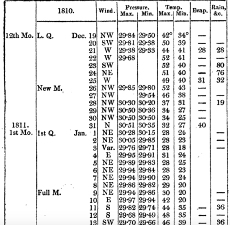
They were also mentioned by Luke Howard in his publication The Climate of London in 1810.
He also mentions winter thunderstorms over the Yuletide period, from Christmas Eve to Boxing Day – the amount of rain overflowing the Thames.
24th: Very windy night with heavy rain. 25th: Wind high all day with rain frequent lightning in the evening from SE. 26th: Wind very boisterous early in the morning day fine the rain of the last three or four days being impeded in its passage to the Thames by the spring tides overflowed the banks and filled the marshes.
Within two days of this wild and wet spell, complete with strong north-westerlies, the wind swung north and then north-easterly to usher in 1811 with a 12-day cold spell.
The conditions of the cold spell were not severe, the coldest night was -8C, it was a pretty standard cold spell for the time and one that the south-east used to experience with fair regularity in the early to mid 1980s.
Models currently show a (fairly) narrow chance of a stormy Christmas period. It would be interesting if it were followed with a cold spell in January – just like the ones we used to get in 1980s.
* The Booty website also contains the following on that notable month…
What is thought to be Britain’s strongest tornado occurred in December 1810. A category of “T8” (on a ten-point scale) occurred on the 14th at Old Portsmouth. The TORRO website says it: “tracked from Old Portsmouth to Southsea Common causing immense damage – although no deaths, it is believed. Some houses completely levelled and many others were so badly damaged that they had to be demolished; chimneys were blown down and the lead on a bank roof was ‘rolled up like a piece of canvas and blown from its situation’.”
Weather models are now in range of predicting the weather on Christmas Day and the all important question of ‘Will it be a white one?’
High pressure centred over the near continent leaves the UK in a feed of very mild air from the Azores
The operational output from the GFS model today answers that question with a resounding ‘no’. A huge anticyclone centred over the continent puts the UK in a very mild SWly feed, the air source from the Azores. You would expect temperatures in London to top around 12C after an overnight low of around 5C.
The Daily Star this morning was even more bullish with it’s splash proclaiming that punters had poured money into Yuletide being exceptionally mild, predicting 15C which would give last year’s record warm period a run for its money. But they have based this forecast on one operational outcome on one model!
Anyone who follows weather forecasts knows that there’s always huge uncertainty in outcomes beyond five days. So putting faith in this forecast 16 days before the event could be dismissed as plain stupid. A closer look at the ensembles – model solutions that pick out trends of several operational runs – suggest that there is very wide spread in outcomes for the weather for Christmas Day: either very cold or very mild! And the GFS system is also hampered by lack of vertical resolution in the stratosphere.
Punters are apparently piling money into it Xmas day being 15C – but ensemble forecasts at this range show outcomes from very mild to very cold.
Taking a broader view of what happens in real life over the last few years there always seems to be a pivotal moment around December 17th. The odds always have to favour the mild weather for us though.
Earlier this month in my November review I found that there was a 55% chance of a cold spell at the end of December. My guess at this range is that the run up to Christmas will see us under the influence of high pressure centred over the near continent – a ‘phantom’ cold spell that is cold at the surface but, at 850mb (5,000ft), well above freezing. Christmas day in London will start frosty with the temperature topping out at 5C or 6C. Any proper cold spell with snow will not bite until 29th.
That’s my guess. My advice to anyone who fancies a flutter is to hold on to your money until the 17th. Or place a bet on both.
* The definition of a white Christmas used most widely – notably by the bookies – is for a single snowflake, even if it lands in the midst of heavy rain, to be observed falling in the 24 hours of 25 December at a specified location recognised by the Met Office.
** On average, snow or sleet falls in the UK 5 days in December, compared with 7.6 days in January, 6.8 days in February and 6 days in March. White Christmases were more frequent in the 18th and 19th centuries, even more so before the change of calendar in 1752, which effectively brought Christmas back by 12 days. Climate change has also brought higher average temperatures over land and sea and this generally reduces the chances of a white Christmas.
November 2016 was the sunniest in a record going back to 1881. Some 91 hours were recorded, 156 per cent above average and a complete contrast to last November which was the dullest for 47 years.
The temperature in the early hours of the 30th fell to -6.1C, colder than any night last winter and the coldest since January 2013
The mean temperature for the month finished 6.4C, that’s 1.5C below the 1981-2010 average ; 4C cooler than last year and the coldest November since 2010. The warmest day occurred on the 15th with 15.9C recorded. The first air frosts of autumn were recorded. The lowest temperature occurred on the 29th when the spirit fell to -6.1C.
Rainfall was 135 per cent of average with 80.1mm recorded. The wettest day was on the 19th when 23.5mm of rain fell.
The sunniest days were on the 2nd, 13th and 25th when eight hours of sunshine were recorded.
Air frosts: 4, Ground frosts: 19
The dolphin-shape of this radar image shows Storm Angus before it hit the south coast. The system stayed far enough south of us not to cause any damage in London
What has December got in store weatherwise? The models suggest the high pressure that has been anchored over us, bringing cold nights, will pull away to the continent. This will allow an ever milder but mostly dry source of air off the Atlantic through to mid month. Days will grow milder while frost and fog will feature less at night.
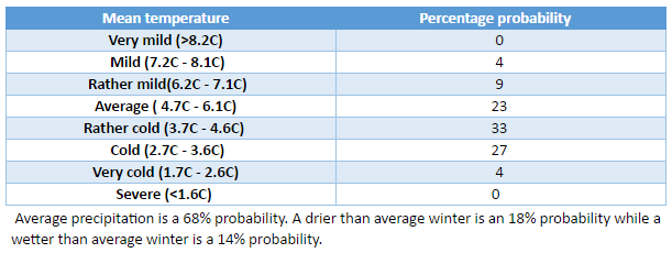
Beyond the grasp of the models my long range outlook method suggests an coldmonth is most likely at 43 per cent probability. Average comes in at 29 per cent probability while rather mild and rather cold are both 14 per cent probabilities.
Rainfall looks finely balanced. Wetter and dryer than average both come in at 43% probability while average is 14 per cent. Given the influence of high pressure at the beginning of the month I’m inclined to think it will be a drier than average month.
So, to sum up, we’re looking at a mean of 4.4C, rainfall: 55mm, sunshine: 39hrs.
My forecast last month was good: predicted mean 6.8C (result 6.4C). Rainfall: 55mm (result 80mm). Sunshine was way off, however – predicted total: 41hrs (result 91hrs)
I have also published a winter forecast covering the London area that you can find here.
Here follows the full weather diary for November…Full stats for the month here:http://1drv.ms/1rSfT7Y
1st: Cloudy and mild all day. Patchy drizzle at times.
2nd: Sunny, cold start after first ground frost of the autumn.
3rd: Sunny, cold start with cirrostratus and cumulus drifting around. Cloud thickened through the afternoon with some light rain around 9pm.
4th: Cloudy, dull start up to 11am. Rain pushed in and lasted for much of afternoon, clearing in evening.
5th: Cloudy, cold and damp start. Some brightness though with a cold wind.
6th: Sunny, cold start, tending to cloud in. Rain after 3pm. Feeling cold but too windy for a frost overnight.
7th: Sunny, cold and very breezy to start, the cloud tending to fill in through the day. Clearer overnight though too much cloud and occasional air prevented an air frost.
8th: Sunny and cold start. Cloud thickened during the day to bring rain after dark at 8pm that then fell through the night – the biggest fall since Brexit day.
9th: Light rain slowly clearing to cloud.
1oth: Cloudy start with light rain showers around 10.30am then cloudy. Some sunny intervals in the afternoon. Milder.
11th: Bright start with cloud decreasing through the morning to leave a pleasant and clear afternoon.
12th: Miserable and rainy to start, this lasting past 11.15am. Drizzle thereafter into 6pm.
13th: Sunny start though cloud tended to fill in through the day. Damp overnight with patchy drizzle.
14th: Cloudy and damp start with some breeze. Brief brightness at noon but patchy drizzle moved in around 4pm.
15th: Cloudy and miserable though very mild.
16th: Sunny start and very mild though cloud tended to fill in during the day making the sunshine milky.
17th: Bright, breezy start, the breeze increasing until a squall blew through at 2.40pm then sunny spells.
18th: Bright start with milky sunshine then tending to cloud over. Feeling cold.
19th: Bright sunshine though cold to start. Patchy altocumulus developed through the day, leaving it to become bright, the strength of the sun diminishing. Rain started around 6pm and fell through night with varying intensity.
20th: Dull and cloudy start with rain returning at 10am. Cloudy afternoon with rain returning late evening and through the night, some heavier bursts.
21st: Cloudy with showers past noon. Heavier showers moved in mid afternoon and fell into the evening.
22nd: Cloudy with a few very light showers around. Breezy.
23rd: Cloudy and breezy. Feeling mild.
24th: Cloudy and mostly dull with brief brightness at noon.
25th: Sunny with just a few cumulus around.
26th: Sunny start but low cloud blotted out the sun around midday then cloudy and cool.
27th: Cloudy and mild.
28th Sunny all day with just a few cumulus floating around.
29th: Sunny all day with frost persisting on grass in shade.
30th: Sunny and very frosty start. Frost persisting on the grass all day with a very cold start to the night. A veil of cloud crossed the region late evening, lifting the temperature above freezing, before clearing before dawn
Frost still lingers on my lawn as I write this winter forecast on the last day of the meteorological autumn. Last night’s minimum was -6.1C, the coldest night this year and, indeed, colder than any night last winter.
It would be very easy to get caught up in the hysteria that happens every November of what the winter will bring. Most of the hysteria comes from ‘coldies’, those folk that hope every winter will be the coldest and snowiest on record. I count myself among them.
The north-west of England looks around 10C above average on December 9
But, despite hints from BBC weather forecasters that something maybe afoot in terms of something colder than usual from mid-December, years of disappointment have taught me to just take winter as it comes. Meteorological models this morning look anomalously warm for the first half of December, the UK being on the warm side of an anticyclone centred over France – the theme of so many winters I can remember.
The current phases of ENSO and QBO suggest that their influence on our winter this year will be far less marked than last year. Looking at teleconnections with a slight La Nina and the current QBO cycle have revealed winters that were fairly uninspiring though by no means write-offs for snow, two examples in the case of QBO being 1985/86 and 1990/91 – both had very cold Februaries.
Before I got too bogged down with trying to find patterns here I decided to move on to my more traditional pattern-matching.
Before I trawled through the figures my initial gut reaction to this winter was that it would be the coldest for at least four years – a not-too-difficult feat giving the mildness of the last three winters which saw very little in the way of snow.
The overall mean temperature for December, January and February came out at as4.2C – 1.2C colder than the 1981-2010 average, with average precipitation.
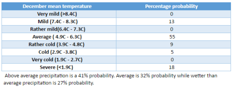
A rather cold winter, over three months doesn’t tell you much. A very mild and stormy December could mask a dry and notably cold February. This makes it worth looking at the individual months of each winter.
There is a lot of spread in the above tables. Considering them altogether I would guess winter will unfold in the following way:
December to start mild, possibly becoming very mild, before beginning to turn very cold mid-month. This pattern will persist, with varying intensity through into January which could also be very cold. Milder conditions to follow in February though this will probably end a fairly average month and drier after a slightly wetter than average December and average January.
As well as my method of using rainfall and temperature I also considered other methods. One was Russian research that states that the weather pattern in the winter will be the opposite to the weather on September 17th and November 7th. This autumn September 17th was N’ly and November 7th was NNW’ly. So, this would suggest a continental flow from S and SSE.
You can read the method of how I reached my conclusion here.
The Met Office’s latest outlook for a relatively high chance of cold weather in the early part of winter has set the internet abuzz with talk that the UK is about to experience its coldest winter in years.
The 3-month outlook, produced by the agency for contingency planners, states:
Lower-than-average temperatures are more probable than higher-than-average values. Overall, the probability that the UK-mean temperature for November-December-January will fall into the coldest of our five categories is 30% and the probability that it will fall into the warmest of our five categories is 10% (the 1981-2010 probability for each of these categories is 20%).
THe ‘30% chance’ for temperatures to be in the coldest of five categories is more significant than it would appear: in this three-year period of mild winters that figure usually hovers far lower.
The continent is not yet cold enough to get excited about this synoptic chart for Monday, November 7th
The Met Office’s method, which includes a combination of data such as QBO, ENSO and ground based observations also agrees with my own method of finding local October singularities back to 1797. This month I found that an average or cold November is most likely: average and cold are both 30 per cent probability. Rather cold and severe are both 20%! There appears no chance of anything mild.
So, we can look forward to ‘a reduction in the normal westerly flow across the UK from the Atlantic, with a greater frequency of northerly or easterly winds’.
But what does this mean for the London area? If the near continent is not cold enough northerly and easterly winds could just bring a succession of cold rain in the form of showers off the North Sea with a higher than average frequency of frosty nights: nothing out of the ordinary for a slightly cooler than average November.
To try and second guess proceedings into December I decided to plot all year singularities to find when the cold spells would most likely fall and how severe they could be.
The results for November look unexciting: the coldest day is likely to be around the 19th with a maximum of 6.9C. The best chance for something cold looks to be in December, around 6th to the 11th – but there again highs of 3C or 4C would mean that any snow would be short lived. There appears to be a warm up in time to scotch hopes of a white Christmas before another cool down toward new year.
So, in conclusion, late autumn / early winter is likely to be a lot colder than the past three years. It is perhaps this fact, together with frosty mornings being common, that will make the season feel colder than it actually is.
I will be publishing my usual winter forecast on December 1st.
The coldest day in November is likely to be around the 19th
October 2016 was yet another dry month, a pattern that has emerged since the middle of June. Just 52 per cent of the October average was recorded.
October saw many pleasantly sunny days
The monthly mean finished 11.5C, 0.3C above average and ending a three-month run of warm temperatures.
Some 105 hours of sunshine were recorded, 98 per cent of average
Air frosts: 0, Ground frosts: 0
So what has November got in store weatherwise? The models on the 1st suggest an anticyclone anchored to our west over the Atlantic will bring a regime of, at times, chilly northerly winds and the potential for rainfall, much probably in the form of showers, driven by low pressure in the North Sea. Where skies clear at night there will be potential for the first air frosts of the autumn.
Beyond the grasp of the models my long range outlook method suggests an average or cold month is most likely: average and cold are both 30 per cent probability. Rather cold and severe are both 20%! There appears no chance of anything mild.
Rainfall appears that it will be skewed toward something above average at 40 per cent, though average and below average are both 30 per cent.
Sunshine looks average at 57 per cent probability.
So, to sum up, we’re looking at a mean of 6.8C, rainfall: 55mm, sunshine: 41hrs.
Numerous holes dug by squirrels appeared in October. The squirrels have no more an idea than we do whether winter will be cold
Here follows the full weather diary for October…Full stats for the month here:http://1drv.ms/1rSfT7Y
1st: Rainy start with showery bursts to 11.25am then through afternoon mostly cloudy.
2nd: Sunny but chilly, feeling very autumnal. Clearing into the evening with a cold night to follow.
3rd: Sunny, gin clear all day until 2.08pm.
4th: Another sunny albeit slightly hazy start then patchy cumulus. Warm in the sunshine even with a easterly breeze.
5th: Sunny start though breezy and with quite a few cumulus around. Cloud streets observed at 10.30am, the cloud tending to decrease and completely melt away by 4pm.
6th: Sunny start but with much cloudier spells at times. Warm in the shelter.
7th: Cloudy all day, the cloud thick enough at lunch time for drizzle that damped the ground.
8th: Cloudy with bursts of light drizzle in the morning, some brightness. A heavy shower at 2pm was brief then cloudy. Clear and cold overnight.
9th: Sunny until 2pm with patchy cumulus – a really glorious morning. Sunny spells in afternoon with cold night to follow.
10th: Sunny with just patchy cirrus first thing. Thick patches of alto-cumulus drifted across from time to time. Cold overnight.
11th: Sunny with patchy cumulus which melted away through the day. Showers after dark, one at 2330z.
12th: Cloudy and damp start. Short, sharp shower at noon then mostly cloudy.
13th: Rainy , wet start thanks to a streamer of moderate to heavy showers.
14th: Cloudy am but with lots of sunshine mid-morning before clouding over again though staying bright.
15th: Bright start but with lots of cloud pushing in and light burst of drizzle at noon. Cloud thickened before rain moved in after 5pm and fell intermittently through the night.
16th: Damp start as the remnants of the overnight rain cleared away, then becoming brighter at 11.15am. Sunny spells for a time before turning cloudier with some very sharp showers on yet another convergence line.
17th: Cloudy start but soon brightening up with some pleasant sunny spells. Heavy burst of rainfall at 5.30pm with more showers at midnight and early hours.
18th: Cloudy though quickly turning bright and breezy with long sunny spells after clearance of the cold front.
19th: Bright start though more cloud around than sun all day. Feeling colder than of late.
20th: Bright and breezy with variable cloud and sunny spells. A short shower at 2pm damped the ground. Clear spells overnight made it chilly. A shower at 9.30am.
21st: Cloudy and chily start.
22nd: Cloudy and cold start, brief clearance at 11am then sunny spells.
23rd: Sunny and clear to start though cold. Sunny spells into the afternoon. Cloudy overnight.
24th: Cloudy and cool during the day and overnight.
25th: Dull and cloudy with only limited brightness. Clear early evening with temp falling before it turned misty. Cloud pushed in raising the temperature.
26th: Cloudy start and turning very dull before bright spells spread in at noon.
27th: Cloudy though getting brighter through the morning with a brief clearance at noon, then bright and sunny intervals.
28th: Sunny and very mild to start. Sunny spells through the day.
29th: Cloudy start with bright intervals after midday. Clear spells after dark with fog forming after 11pm which gave a foggy start.
30th: Foggy start then cloudy and miserable.
31st: Fog to start then clearing at 11am. Gorgeous sunny day thereafter.
You must be logged in to post a comment.