Months of snow on way? It’s too early to tell

Sections of the tabloid media have been going into overdrive these past couple of weeks with tales that the UK will soon be in the grip of an Arctic freeze – one headline in the Daily Express boasted that parts of the UK were in for FOUR MONTHS OF SNOW.

excess
The Daily Express ‘forecast’ was published at the end of September

These stories are nothing new though they seem to be published earlier and earlier in the autumn. By the time we reach November – once the traditional time when winter forecasts started appearing – the tabloids have already turned their attentions to spring. Much of it is just ‘clickbait’ – a means for publishers to prove their stories are being read to keep their advertisers happy, a symptom of an industry in financial dire straits.

There will be snow somewhere in the UK during the next five months but predicting heavy snowfall in a given area, such as London, is impossible. But given the outrageous claims at such a long way from the start of the season on December 1st I decided to have a look to see if there is anything wintry on the horizon.

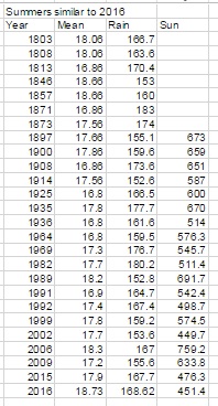
I started by comparing a range of historic datasets, including quasi-biennial oscillation (QBO) and el niño–southern oscillation (ENSO), against monthly mean temperature and rainfall anomalies. Because ENSO data only goes back to 1950 the findings are obviously far more restricted than my winter forecast method which uses local data going back to 1797.

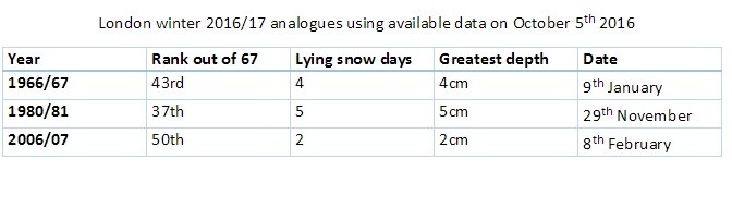
The results of my data trawl are underwhelming. The best fit years were as follows:

analogues

For anyone who likes snow the above is not encouraging, however, given the past year which has seen several daily and monthly records shattered, including a record warm December, who’s to say that recent warm temperatures will suddenly swing the other way.

The above table would also suggest that the coming winter will be colder and snowier than the previous three – but that gives little away given how mild the past three winters have been.

scand
October 2016 has seen a strong blocking high become established over Scandinavia, the earliest this has happened since 1881.

A study of mean temperature anomalies in London since 1950 suggest that sudden swings, both positive and negative, are becoming more likely. Last month was the fifth month in a row that I recorded a positive anomaly – the longer this goes on the more likely it is the mean could turn negative – though bear in mind that I have recorded 12 months in a row of positive anomalies, from February 2011 until January 2012.

Current weather also suggests that something maybe afoot with the earliest establishment of a strong anticyclone over Norway (the fabled Scandinavian high) since 1881! This weather pattern gives the south-east its best chance of snow with the feed of cold air often coming all the way from Siberia. Time and again, however, I’ve seen these patterns break down in November just as everyone starts talking about an imminent severe winter. There is more than an element of truth to the saying:

Ice in November to bear a duck, rest of winter will be slush and muck

In conclusion, while the early figures look bleak for snow in the low-lying south-east, it is still far too early to tell if the coming winter will be mild or cold.


September 2016: very warm, very dry

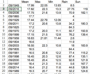
Last month was the second warmest September in a local record going back to 1797! The monthly mean finished 17.8C, 2.4C above average. Despite being an ‘autumn’ month September was actually a full degree warmer than June!

screen-shot-2016-10-01-at-11-55-19
September 2016 was the second warmest in a local record back to 1797, though we’re talking by fewer than tenths of a degree.

The hottest September day since 1959 was recorded on the 13th when 33.1C was reached, the sixth equal hottest in the local daily record back to 1848.

The month also saw the warmest minimum recorded since 1959 when the mercury failed to fall below 18.7C on the 6th.

It was another very dry month, the third much drier than average month in a row: just 27.7mm fell, 24 per cent of average, making it the driest September since since 2007 and the 12th driest in the local record.

Like August, the month only falls down in terms of impressiveness when sunshine hours are considered. Some 119 hours were recorded, that’s 85 per cent of average, making it the dullest September for 15 years.

Air frosts: 0, Ground frosts: 0

So what has September got in store weatherwise? The models on the 1st suggest that a large Scandinavian high will become established to our NE bringing lots of settled weather and showers on coasts. There’s obviously the chance of trough disruption as the month progresses if the anticyclone’s influence declines.

Beyond the grasp of the models my usual long range outlook method falls down this month due to September’s warmth and dryness – there is nothing within  +/- 10% of September’s statistics. I would guess, however, that we are looking at another drier than average month with frost becoming a risk as the month progresses where skies clear. There is also the chance of more pleasant autumn days where skies are clear during the day.

My September outlook for temperature was poor. I predicted a mean of 15.3C (outcome: 17.8C). It was much, much drier than I thought: 300mm (outcome: 27.7mm). Sunshine was poor: 140 hours (outcome: 119 hours).

Here follows the full weather diary for September…Full stats for the month here:http://1drv.ms/1rSfT7Y

1st: Sunny start but cloud gradually increased until it was overcast by 6pm. Clear spells overnight but warmer than previous nights.
2nd: Cloudy though some brighter intervals.
3rd: Sunny start, cloud began to pile in at 12.30pm with rain arriving at 5.30pm, this fell through the evening with some showers in the early hours.
4th: Bright, breezy start but rapidly turning cloudy and dull. Some rain overnight.
5th: Light rain and dull to start – this quickly clearing to cloud by 3pm. Things remained cloudy with a muggy night.
6th: Cloudy, dull and muggy start after warmest September night on record. Another warm night though muggy.screen-shot-2016-10-01-at-12-22-03
7th: Cloudy to 11am though sun breaking through as drier air arrived. Feeling humid.
8th: Sunny start but with plenty of cumulus, this quickly decreasing to leave clear sky.
9th: Cloudy morning though sky seemed to periodically clear of low cumulus before becoming overcast and very breezy in the afternoon. Some rain overnight and just before obs time.
10th: Cloudy start with patchy light rain, this briefly turning  heavy at 1pm  before turning occasionally moderate. Dreadful afternoon after recently. Clearing overnight to leave a sunny start.
11th: A glorious sunny day with only the odd patch of cirrus.
12th: Bright start with some sunshine, clouding over with a few splodges of rain with warm front. Then sunny and very warm.
13th: Sunny start with a few cirrus and castalanus around. Breezy at times with the thermals. The warmest September day since 1959 and 6th equal warmest since 1848.screen-shot-2016-10-01-at-12-13-54
14th: Sunny start with a few cirrus. A few patches of alto-cumulus later. Very warm but not as hot as yesterday. Warm, pleasant evening.
15th: Sunny with a few wispy cumulus, clearing to hot sunshine. Some alto-cumulus developed at 2pm and towering cumulus could be seen in distance. Thunderstorms reporting to NW of London. Cloudy and warm overnight with eight peals of thunder in the early hours and heavy rain.
16th: Light to moderate rain through the morning, petering out at 1.30pm.
17th: Cloudy, cool and breezy all day, at times dull.
18th: Cloudy all day, a bit warmer than the previous two days.
19th: Cloudy start though with sun breaking through briefly at 11am until 1pm then cloudy again. Rain at 1am that didn’t last long enough to register.
20th: Cloudy and fairly calm – a nothing day with odd very light drizzle.
21st: Bright start with cloud breaking to long spells of sunshine before more cloud moved in. Warmer than of late.
22nd: Cloudy but  sun broke through giving pleasant afternoon and cool overnight.
23rd: Sunny, gin clear and cold start. Just a few fair weather cumulus through the day.
24th: Sunny start with cloud decreasing. Very warm in sun but cloud and breeze built through the day. Overnight light rain between 6am and 9am.
25th: Bright start after overnight light rain.
26th: Bright start with a few cloud breaks here and there. Heavy shower at 12.15pm with further threat of rain but stayed dry.
27th: Bright start with signs of a cold front moving in from south then cloudy.
28th: Sunny start with patchy cirrus, this tending to thicken at lunchtime to turn mostly overcast with humidity increasing. Breeze also picked up with reappearance of sun mid afternoon. Cloudy, very mild and breezy rest of the day.
29th: Cold front and brief heavy rain swept in at 10.03am. Then intermittent falls until 11.23am.
30th: Sunny, gin-clear start, patchy cumulus bubbling up at 10.30am. Cloud grew thicker around 12 noon with brief shower at 1pm. Then sunny spells and cloudier periods. Another shower just after nightfall then clear. Cloud moved in after 2am with another shower. Early sunshine  gave way to moderate showers around 9.45am.

A mostly quiet and dry autumn on the way?

I don’t usually bother trying to forecast autumn or spring given that there is far less interest in them than winter and summer. However, given the heightened interest in this year’s hurricane season and emboldened, perhaps foolishly, by my reasonably correct summer forecast I decided to have a look at the stats and see if I can find any signs where autumn in east London may be headed.

Using the methsummer simsod for my seasonal forecasts resulted in a shortlist of 26 summers that were similar to 2016.

Because the NOAA ENSO index only goes back to the 1950 I decided to disregard all years prior to this date to try to make any results more reliable. This narrowed down the list to 11 years.

With these considered I then searched for years that had a similar ENSO index to June (0.1 – neutral) with a tendency to turn negative (La Nina). This narrowed the field further to three years: 1999, 1992 and 1964. However, the only year that is showing signs of being similar with regard to where the ENSO index is forecast to be heading is 1964.

Although, so far, there has been an uptick in hurricane activity similar to 1964 there is, of course, the added consideration that Saharan dust is playing a part in impeding the formation of these tropical storms in the Gulf of Mexico – something the weather models seem to struggle to get a grip on.

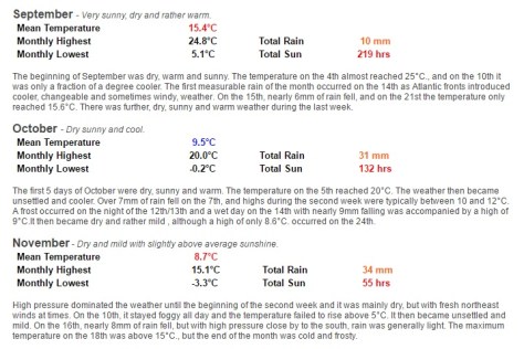
With this in mind perhaps there will also be lower than usual instances of these storms crossing the Atlantic to affect the UK: hence a quiet autumn though, on a national scale, interpersed with the odd interest from the Atlantic. weather notes 1964In London, perhaps we can expect something very similar to what is listed on the excellent website: http://www.london-weather.eu/article.103.html
autumn 1964


Summer 2016 review

Summer 2016 turned out to be a very decent season overall, the mean temperature of 18.7C (1.1C above average) made it the sixth warmest summer since 1797.summertop20

While it wasn’t quite up there with the hot summers of 1976 and 2003 it still produced some notable records. The stormy beginning to June effectively ended with the Brexit vote, a period of 24 hours that coincided with the highest daily rainfall this area has seen since at least 1959.

The multi-cell thunderstorm in the early hours of June 23rd produced 60.8mm of rainfall, nearly half of the month’s total which became the third wettest June in a record going back to 1797. The high rainfall was in complete contrast to July and August and helped skew the overall figure: 168.6mm is 114 per cent over average summer rainfall.

sunWith so much rainfall overall sunshine was affected with only 451 hours recorded, just 80 per cent of what can be expected in an average summer.
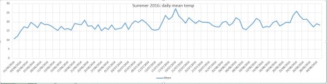
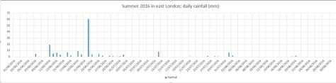
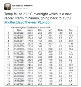
July produced another record, this time the highest overnight minimum recorded since 1959. The minimum of 21.1C was recorded during the early hours of the 20th – coming hours after the hottest day of the year: 33.5C – the 14th hottest day on record.

The warm and very dry theme continued into the final month of summer with the warmest August for 12 years, the 10th warmest and 12th driest since 1797.

My summer forecast, when the monthly probabilities are considered, was broadly correct though I didn’t estimate correctly just how warm it would be.

Mean forecast: 16.7C (outcome 18.7C)
Rainfall forecast: 166mm (outcome 168.6mm)
Sunshine forecast: 546hrs (451.4hrs)

summer2016mean

summer 2016 rain

summer 2016 sun


August 2016: warm and very dry

Though there were no records broken August 2016 goes down as a mighty fine summer month, the warmest for 12 years. The mean of 19.5C was 1.3C warmer than average and only 0.1C cooler than 2004.

wanstead park
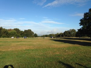
Grasslands around Wanstead Park have gradually turned brown because of the lack of rainfall

The month ended a three-year run of poor or so-so Augusts: in terms of mean temperature the month was the 10th warmest in a local series going back to 1797.

It was another very dry month: just 11.9mm fell, 24 per cent of average, the driest August since 2003 and the 12th driest in the local record.

The month only falls down in terms of impressiveness when sunshine hours are considered. Some 192 hours were recorded, the 59th sunniest since 1797 – 1995 had 80hrs more sun.

Air frosts: 0, Ground frosts: 0

So what has September got in store weatherwise? The models on the 1st suggest the month will start mixed, though any precipitation will be below average. Temperatures remaining on the warm side.

warmest augustsBeyond the grasp of the models my long range outlook method is again hampered by a very dry August. However, the data I do have suggests an average month at 100 per cent probability.

A wetter than average month looks most likely at 75% probability.

The rainfall probability makes me wonder whether we are in for a very unsettled second half of September, the Atlantic cranking into life with the remnants of tropical storms and hurricanes having an ever-increasing influence as the month progresses.

So to sum up: mean 15.3C (average), rainfall 162mm (300%), sunshine 140 hours (100%).

driest augustMy August outlook for temperature was good. I predicted a mean of 19C (outcome: 19.5C). It was drier than I thought: 30.3mm (outcome: 11.9mm). Sunshine was poor: 239 hours (outcome: 192 hours).

Here follows the full weather diary for August…Full stats for the month here:http://1drv.ms/1rSfT7Y

1st: Cloudy start to 1pm. Rain started at 5pm through to 10pm. A brief interlude before more light to moderate rain through the night 4.30am, then drizzle
2nd: Damp, miserable start – the rain became light to moderate in the early afternoon before drying up – very high dew points through the day.
3rd: Bright and breezy with variable cloud.
4th: Bright start with variable cloud and sunny spells.
5th: Good sunny spells all day – perfect summer’s day, not too much humidity – though an isolated shower passed over at 8pm.
6th: Sunny, clear start. Lots of sunny spells during the day.
7th: Bright start though very breezy. Cloud decreased through the day to leave a gorgeous late afternoon and evening.
8th: Sunny, clear start with lots of fair weather cumulus throughout the day. Cloudier spells mid afternoon.
9th: Sunny with fair weather cumulus up until noon then cloudy afternoon.
10th: Sunny with fair weather cumulus, variable throughout the day. Breezy.
11th: Cloudy start with very brief light rain, barely enough to damp ground. Some sunny intervals later and bright and warm.
12th: Sunny start with a few clouds. Turned gin clear at 11am and stayed clear all day. Feeling hot.
13th: Bright start but turning cloudier. Sunny intervals PM.
14th: Cloudy start breaking to some long sunny spells. Feeling very warm in the sun.
15th: Bright start soon turned sunny with a clearance at 1pm.
16th: Bright start though a lot of haze around. Sunnier later though still hazy.
17th: Sunny with patchy cloud to start, this clearing late morning to leave a clear if rather hazy afternoon.
18th: Sunny if a bit hazy to start, this tending to decrease to leave warm sunshine.
19th: Cloudy with rain threatening. Low cloud at Stansted. Brief rain in afternoon then cloudy.
20th: Dull and overcast at 9am. Burst of heavy rain at 10.15am clearing to sunny spells at noon 30. Rain between 7pm and 8pm and 3am and 4am.
21st: Bright start. Sunny intervals till 3pm then sunny spells.
22nd: Bright after earlier rain at 0719 then sunny spells.
23rd: Clear and sunny start with a few cirrus clouds through the day. Hot.
24th: Sunny, gin clear start. Patchy cirrus through the day. Hot.
25th: Lots of altocumulus and sunny spells but felt sultry due to high dew points.
26th: Cloudy start but gradually decreased to leave clear pm.
27th: Overcast but bright start. Brightness through the day but hazy. Some heavy storms further north.
28th: Overcast until early afternoon, 5 minute shower at 2pm then sunny intervals..
29th: Bright start then sunny spells and cirro cumulus gradually clearing to leave a sunny evening and clear night.
30th: Clear and sunny start.
31st: Bright start though cloud filling in by 3pm, clearing again at 8.30pm

Heat: A tale of two airflows

The past few days have offered a couple of perfect examples of how wind direction can have a massive effect on the resulting maximum temperature at this time of year.

Friday, August 12th and Monday, August 15th, were both very similar in that any morning cloud completely cleared by 11am. But while the wind blew from a SW’ly direction on Friday, nudging Wanstead up to a very warm 28.1C, by Monday the high pressure had drifted north, drawing in a cool NE’ly flow off the North Sea. The high temperature in Wanstead on Monday was nearly four degrees cooler at 24.4C.

Under these conditions temperatures will be warmer the further west you go, as the graphs below show.

12082016
Highs to 6pm on 12th were: Wanstead 28.1C with Northolt reaching 27C

fax12082016

15082016
Highs to 6pm on 15th were Northolt at 25C. Gravesend, being furthest east and most influenced by the cooling North Sea breeze reached 22.6C

fax15082016

July 2016: rather warm and very dry

There was plenty of interest in the weather last month even though the overall stats suggest July 2016 wasn’t that remarkable.

july 9 sky
The sunset on July 9th was spectacular

Most notable was temperature: the warmest minimum on record for this area (21.1C) was recorded during the early hours of the 20th – coming hours after the hottest day of the year: 33.5C – the 14th hottest day on record. The mean temperature of 19.5C  was a degree warmer than average, the 18th warmest July since 1797.

Rainfall was very sparse. A total of 17.3mm fell during the month, that’s 40 per cent of average, the driest for six years and the 19th driest in the series going back to 1797.

After a very dull start to the month sunshine was always going to struggle: just under 172 hours were recorded – that’s 89 per cent of average and marginally down on last July.

Air frosts: 0, Ground frosts: 0

record warm min
The temperature didn’t fall below 21.1C on the night of 19th July, making it the warmest minimum on record in this area back to 1959

So what has August in store weatherwise? The models on the 1st suggest the month will start with a mixture of sunshine and showers. At the end of this week there are indications of a change to warm and later very warm weather.

Beyond the grasp of the models my long range outlook method is hampered this month because of the very dry July. However, the data I do have suggests a rather warm month at 50 per cent probability. The ‘worst case’ scenario suggests something average, a contrast to  the past couple of Augusts which have been poor. Perhaps we can look forward to another reasonable summer month, defined by plenty of fine, at times hot, weather – though anyone looking for unending days of 30C and higher will be disappointed.

A dryer than average month (possibly very dry) looks most likely at 50% probability. A very sunny month looks most probable.

So to sum up: mean 19C (0.8C above average), rainfall 30.3mm (60%), sunshine 239 hours (123%).

hottest dayMy July outlook for temperature was good. I predicted a mean of 18.8C (outcome: 19.5C). Rainfall was very poor: 50mm (outcome: 17.3mm). Sunshine not badr: 171.9 hours (outcome: 190 hours).
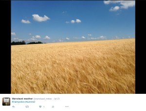
Here follows the full weather diary for July…Full stats for the month here:http://1drv.ms/1rSfT7Y

1st: Cloudy with sunny intervals. Some sharp showers.
2nd: Bright start though breezy. Very heavy shower at 1740.
3rd: Sunny though with lots of cumulus.
4th: Sunny, gin clear start though cumulus rolled in at 1.30pm.
5th: Cloudy start with very brief, very light drizzle though with sunny breaks developing.
6th: Hazy mix of cirrus and cumulus gradually decreased to a clear sky by 1pm. More cumulus bubbled up later but still mostly sunny and low humidity.
7th: Sunny start with lots of cumulus, cirrus and stratus around. Sunny spells through the day.
8th: Cloudy and breezy start.hants
9th: Bright start with sunny spells but also lots of cloud. Amazing sunset with fronts coming in.
1oth: Cloudy start with light rain spreading in but only lasting for 40 minutes. Some sunshine in the afternoon though was breezy.
11th: Cloudy start with heavy showers early afternoon.
12th: Sunny start though with plenty of cloud which bubbled up and gave heavy showers from 11.30am. More showers in the afternoon – miserable.
13th: Bright and sunny to start that cloud gradually built before heavy showers hit at 2pm, these lighter over Aldersbrook.
14th: Sunny, bright start with sunny spells, tending to turn cloudier.
15th: Bright start but cloud piled in and breeze picked up.
16th: Sunny start with lots of cirro-cumulus. Cloud tended to build at times and a front passed over at 4pm. Warm evening and night.
17th: Bright start though with lots of heavy cumulus around. This tended to break up at intervals during the day, making it feel hot in the sun because of the high humidity.
18th: Sunny start with patchy cirrus and cumulus. This decreased as day wore on leaving a hot day. Felt almost airless with variable cloud.
19th: Sunny with decreasing cirrus to start to leave a gin clear day. Breeze picked up at noon meaning it wasn’t as warm as it could have been.
20th: Sunny but hazy start but with more of a breeze than yesterday. Cloud tended to fill in but then burnt off to leave another hot day.
21st: Sunny but cooler start than yesterday with lots of milky cumulus around.
22nd: Cloudy start after overnight rain. Sun breaking through at 12.30pm.
23rd: Cloudy start with spots of drizzle at 11am then slowy getting brighter with evening sunshine.
24th: Cloudy start with early showers breaking to sunny spells.
25th: Sunny start with variable amounts of cloud through the day. Feeling cooler.
26th: Sunny start though with cloud bubbling up through the morning. Overcast by 2pm.
27th: Cloudy and damp with light rain before and after obs time.
28th: Sunny periods with variable cumulus
29th: Cloudy start with brief rain showers in Chigwell. Sky broke to allow long sunny spells before it clouded over again. Rain shower at 9pm.
30th: Cloudy and overcast start. Long sunny spells into the afternoon.
31st: Sunny start though more cloud tending to bubble up in the afternoon.

London to Dunwich by bike in the dark

Hypnotised by a long line of red lights and a sudden feeling of being totally alone in the darkness were surreal sensations I experienced as I took on the challenge of the Dunwich Dynamo last weekend.start

I’d read a few personal accounts of this 120-mile blast through the Essex and Suffolk countryside but nothing really prepares you for the ride that starts in the fading light of East London.

A sea of cyclists greeted you as you arrive in London Fields – a mix of serious lycra together with quite a few souls in regular clothes who look as if they were popping down the shops for a pint of milk rather than an overnight ride to the coast. The park was also still busy with people out enjoying the warm weather with the thermometer still hovering around 25C. Though the event has been running for 24 years a couple of bemused onlookers asked me “what the hell is going on”.

“This is NOT a race”, screams the first line of a sheet of A4 directions handed to me by one of the organisers. And without any fanfare, at 8pm, legions got on their bikes by the Pub on the Park. My intentions of grabbing a big bowl of pasta before the start were soon forgotten as I joined the throng making its way through the narrow confines of Martello Street bike path.

The procession through Hackney was not everyone’s idea of fun though the sheer number of cycles was enough to stave off even the most impatient motorists.

eppingEast London quickly turned into suburban Essex and the scrum of cyclists had already turned into a single file. The sun was already set by the time we reached the Wake Arms roundabout though I assured my two cycling buddies that there would be plenty of options for pasta and coffee in Epping – noble intentions that ended up as pork pies and cans of Coke from Londis…

I’d never cycled beyond Epping – unknown roads even harder to navigate in the darkness. Familiar names started to flash past: Moreton, Fyfield, Leaden Roding and the 32-mile point Great Dunmow. Pockets of villagers screamed encouragement at cyclists including a four-person handbuilt contraption, tandems and one brave cyclist who’d brought his child along in a trailer.

nags head moretonWe stopped for a pint in Great Bardfield at 43 miles; locals joining in the party atmosphere as cyclists either stopped or pedalled on. Although just gone midnight conversations seemed to hover over the fast pace of the tour, probably helped by the fine weather and almost constant light westerly breeze. Finchingfield, Wethersfield, Sible and Castle Hedingham then passed in quick succession before we reached the halfway point at Sudbury about 1am where huge queues had formed for coffee and a barbeque put on by the local fire crews.

Though the temperature never fell below 16C over the entire event tiredness was now starting to set in but before we got too ensconced in our chairs we decided to push on.

sudburyIt was this part of the event where groups of cyclists started to spread out though, because most were cycling at roughly the same speed, you started to notice the same people: the guy in the Heinz baked beans top, the group cycling for Alzheimers, the guy with the kiddie trailer (again) comes into view, the child still awake and appearing to be transfixed by a tablet. I exchanged pleasantries with a guy in a top with the dragon of Wales emblazoned on the back – inane conversations though most seem happy to just get their heads down and eat up a few more miles.

martin sizewell
Sizewell B is getting closer

It was around Bildeston that the roads suddenly seemed to turn really dark. Pedalling on I focus on the line of red lights in the distance – almost hynotised by the rhythm of the whole thing – but then suddenly realised that I was cycling downhill at roughly the same speed as I would in daylight. I turned my head to find that my two cycling buddies were nowhere to be seen, and neither were any other riders. An overwhelming feeling of being alone suddenly dawned on me and I eased back on the pedals though it was a good 10 minutes before my companions catch up – one asked just what exactly was in the muesli bars that I had been munching away on for six hours.

At 3am the delirium started to set in: the University Challenge theme tune was going on a loop in my head – a couple of cyclists that have brought along loud speakers failed to distract me. Our charge to the coast was eventually interrupted by a puncture, my cycling buddy exclaiming in the darkness: “This wheel doesn’t feel right!”.

moretonBy 4am the sky had long begun to lighten and the fading batteries of many riders’ headlamps was no longer such a pressing issue. I think it was around Sibton Lake that pop-up cafes started to emerge at the side of the road. Alas, the long queues prevented us from stopping, so terrified were we that if we stopped for too long our bodies would cease up. No matter. Many other cyclists by now were beginning to stop and rest on verges; a few oblivious that the sun was beginning to rise as quick as they were falling into a slumber.

framlinghamDunwichThe last 10 miles from Framlingham, once the sun had risen, seemed to be the hardest. I’m not sure if it was my brain being unable to cope with the additional distraction of having to deal with looking at beautiful countryside. And a couple more inclines seemed to be the last straw for a few cyclists who got off and walked.
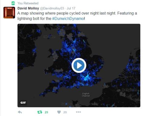
The pine scrub of Minsmere spread out after passing through Darsham before our ultimate destination Dunwich, the Lost City, ended our odyssey. After 10-and-a-half hours we’d done it.

beacg
I’ve managed to raise over £1,000 for Sarcoma, the soft tissue and bone cancer charity

strava

sulston


Synoptic similarity: 2 hot days compared

synoptic

A link to the actual word document can be found here: https://1drv.ms/w/s!Au79-nZSg0ihlDSwLH2fQVGLWBNK

June 2016: extremely wet, dullest on record

Storm clouds gathering was a common sight in June 2016, but enough about the tumultuous political situation…

lake
The levels of Heronry pond have benefited immensely from the rainfall which was 2.5 times the average in June

For anyone looking for summery weather there was little to cheer about. For sunshine the month was the dullest June in a record going back to 1797. Just 96 hrs were recorded – which is just over half what we can expect in an average June.

Most notable was the rainfall: just over 139mm fell which is 272 per cent of average, and the third wettest since 1797. Only 1903 and 1860 were wetter. The month also saw the record broken for highest daily rainfall in a 24-hour period. A multi-cell thunderstorm in the early hours of the 23rd saw 60.8mm fall, most of it in two hours, bringing flash floods to the surrounding area.

fax
The synoptic situation at midnight on June 23 when the heaviest rainfall this area has seen since at least 1960 fell

With the lack of sunshine and copious rainfall it is, perhaps, surprising that the mean temperature for the month finished just above average: 16.8C is 0.7C above the June average. The warmest day was the 10th with 25.3C recorded – only one other day saw the mercury exceed 25C – very unusual for this time of years.

Air frosts: 0, Ground frosts: 0

So what has July got in store weatherwise? The models on the 1st suggest more of the same weather that we have seen during the last third of June. Sunshine and showers with the occasional ridge possibly calming things down for a few hours.

blake
Roads in Wanstead were turned into rivers in the early hours of June 23rd

Beyond the grasp of the models my long range outlook method suggests a rather warm month at 50 per cent – so given the cool start perhaps we can look forward to something summery in the final half to one third? Rainfall and sun looks inconclusive so I would guess average. Because of the high rainfall last month I think my long range method falls down.

A slightly wetter than average month looks most likely at 50% probability. Sunshine probably about average.

So to sum up: mean 18.8C (0.3C above average), rainfall 50mm, sunshine 190 hours.

My June outlook for temperature was good. I predicted a mean of 16.9C (outcome: 16.8C). Rainfall was very poor: 38mm (outcome: 139mm). Sunshine very poor: 178 hours (outcome: 96 hours).

Here follows the full weather diary for May…Full stats for the month here:http://1drv.ms/1rSfT7Y

1st: Cloudy and cool all day.
2nd: Cloudy and cold all day, brief brightness at 11am.
3rd: Cloudy and cool all day, limited brightness late morning. Cloudy overnight with limited breaks – air was very humid with warm front and visibility severely limited.
4th: Cloudy all day though cloud was lighter and air felt warmer because of the warm front that came in yesterday from Europe. Brief milky sunshine at 7pm.
5th: Cloudy up until 9.30am when the cloud began to thin. Sunny spells from 11am before a clearance at 1pm interspersed with occasional cloud.
6th: A gloriously sunny day all the way through. A lovely evening too.

sunsetflats
Sunny sunsets were rare in June

7th: Sunny start but cloud rolled in at 1.30pm with thunder heard all around Wanstead. Some serious flash flooding in Croydon. Highest official total was over 40mm in Kenley. Just 1.7mm during the day but trough brought rain at 5am, about 3mm.
8th: Sunny start but felt very humid and oppressive. A thunderstorm skirted Wanstead at 1.40pm with thunder and much rain in Chigwell, not much in Wanstead. More thunder at 2.10pm. Rain came and went for rest of day until 7pm – very little upper air movement. Mostly cloudy overnight.
9th: Cloudy start but some sunny spells developing.
10th: Cloudy start but soon decreased with long sunny spells developing. Lower humidity so felt pleasant.

chigwellrain
Heavy rain in Chigwell

11th: Cloudy and humid start with very heavy rain at 3pm. This lasted for 45 minutes. More rain fell sporadically through the day, evening and overnight.
12th: Cloudy after moderate rain. Showers and longer bursts of rain returned before a brief clearance at 3pm. More showers piled in with a real corker to the north of Wanstead.
13th: Damp start soon led to light rain, turning persistant at 11am. Then outbreaks of rain throughout the day, evening and overnight.
14th: Light rain to start but this quickly gave way to heavy showers all day. Some brightness at 6pm then turning drier overnight. Gin clear dawn.
15th: Sunny start but with lots of convective cloud. Some drizzle but a heavy shower stayed to the east of Ilford.
16th: Bright start with sunny spells, more breeze than recent days
17th: Lots of cloud around though sunny spells arrived early afternoon. Then showers between 5 and 6pm.
18th: Cloudy with spots of drizzle. Feeling cold all day – a maximum of only 16.5C.
19th: Sunny start but cloud gradually increasing all afternoon. Rain by nightfall that fell intermittently for hours. Rain again at obs time.
20th: Rain to start that lasted, with variable intensity, through the morning. Sunny spells from mid afternoon.
21st: Sunny start with just a few cirrus and cumulus, this tending to increase through the morning to leave an overcast afternoon. Cloudy overnight – a few spots of drizzle on school run as frontal wave started to move across UK.
22nd: Cloudy start with warm sector drizzle. Showers developed at 11pm, much thunder and lightning and the rain turned really heavy through the early hours.

rainjune
Extremely heavy rainfall during the early hours of the 23rd

23rd: Cloudy and humid to 1pm. Showers at 3pm.
24th: Sunny with variable cloud. Feeling humid in the sunshine.
25th: Bright start with sunny intervals. Light shower at midday. Thunderstorms at 2pm, 4pm and 9.30pm.
26th: Sunny spells though significant cloud at times. Rain between 4 and 6pm.
27th: Mostly cloudy though with some brightness after noon. Warmest point was in the evening at 7pm.
28th: Bright though cloudy start. Some sunny intervals but rain late afternoon into the evening. Cool overnight.
29th: Cloudy and breezy, some rain in the air early afternoon and again in the early hours
30th: Cloudy with slight breeze. Some light rain in the early hours.

Meteorology-based musings about east London and beyond