It’s not often you experience what it’s like to be right under a cloudburst but June 2, 2017, provided a perfect example.
Some 31.2mm of rain fell in little over an hour accompanied by frequent thunder and lightning. Some flash flooding was reported and there was an 8C fall in temperature in 2 hours. The max rainfall rate was 108.4mm/hr at 3.49pm.
Elsewhere in London there were reports of ‘golf ball sized’ hail in Orpington. Here is a link to the pictures posted on ukweatherworld.co.uk https://1drv.ms/w/s!Au79-nZSg0ihlSXF5dTb08AQB74b
Tudor Hughes, of Warlingham, NE Surrey, said: “Heavy thunderstorm 1525Z.. Torrential rain and a short spell of large hail near the end. The stones were all spherical with a maximum diameter of 12 mm. Temp fell “vertically” from 22° to 17°. Just measured the rainfall – 12.7 mm, the bulk of which fell in about 7 mins. Rain now (1555 Z) ceased but plenty of Cb still around.”
Smartie, a contributor to the Google group Weather and Climate, explained the science behind the storm.
“The cold front was still to the west, these showers were in a prefrontal trough. South-east London was in the inflow region of the convergence zone and strong initial updraughts and unimpeded ingestion of air from the SE likely accounts for the hail. Storms north and north-east of London likely benefited from urban heat.”
The showers were in a prefrontal trough. Here is the 15 UTC WRF_LAPS objective 10m wind analysis. Red shades are convergence, blue-green divergence. SE London was in the inflow region of the convergence zone and strong initial updraughts and unimpeded ingestion of air from the SE likely accounts for the hail. Storms north and north-east of London likely benefited from urban heat. Chart courtesy of David Smart (UCL)This chart is a SharpPy analysis of the GFS analysis 12 UTC for the Heathrow grid point. Courtesy of Smartie
The synoptic chart for 12Z shows the slack flow over London, the perfect set up for slow moving thunderstorms.
The dry nature of spring this year has scuppered a large part of my usual method of trying to predict the summer season.
With El Nino forecast to be neutral I decided to once again rely on pattern matching of meteorological data from this area for March, April and May stretching back to 1797.
The mean for the spring season, the second warmest on record, was 11.9C with 88.6mm of rain and 430.3 hours of sunshine.
If you take into account all years that were within +/- 10 per cent of these figures, for rainfall some 12 ‘best fit’ years emerge. I normally go on to reduce the list further by considering mean temperature but, this year, no figures would remain!
The list of 12 summers, ranging from 1807 through to 2005, saw all manner of summers, including 1808 when early July heat gave way to fierce thunderstorms with hail the size of tennis balls recorded. Only one was a real corker, 1906, but most were fairly nondescript.
As an average this summer could be expressed as: Mean: 17.2C (just below average) Rainfall: 141mm (about average).
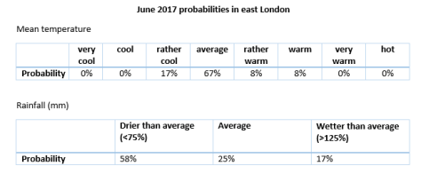
Or, expressed in probabilities, I concluded the following:
From the above you could deduce that the next three months will be around average, with average rainfall.
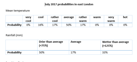
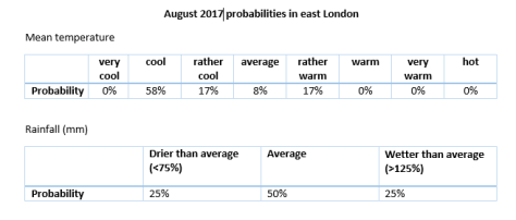
To try to give some idea of what month will have the best weather I’ve broken down the summer into June, July and August probabilities.
Looking at June, considering the unsettled outlook after the weekend, I would guess that a few very warm, thundery spells are possible– though much of any precipitation will stay to our west.
On to July. After an average June I wonder if the ‘return of the westerlies’ will happen just in time to affect this month?
The above chart would suggest that July will be classically average overall. Fine, not too hot spells, with occasional depressions bringing cooler weather and showers.
On to August. Apart from last year this month has been a real disappointment the previous few years. Looking at the probabilities would suggest that August will be the most disappointing month.
Looking at the above probabilities there seems a fair chance of something cooler than average.
There’s not really much to go on. I note the Met Office is going for ‘warmer than average’ but a look at their methodology and the coming season doesn’t look that exciting.
* Taking into account the fact that temperatures in London are up to 0.66C warmer than they were 100 years ago I have added 0.66C to mean temperatures before 1915.
** Obviously, in the event of a series of direct hits from thunderstorms, my rainfall estimate could be hopelessly short – a symptom of abundant solar energy at this time of year which creates a ‘noisy’ atmosphere compared with winter.
*** The 1981-2010 average mean for summer in this region is 17.6C, with 144.9mm of rain and 564 hours of sunshine
The Alpine snowfall season finished just below average in the Splügen area of the Swiss Alps. Abnormally warm weather after decent snowfalls in February and March curtailed the season; mean temperatures finished over a degree warmer than average between November and April.
The figures make depressing reading for anyone who enjoys winter sports and come after a study suggested that bare Alpine slopes could become a much more common sight in the future.
I first visited this area of the Alps in 1981, returning most February half-terms, apart from 1989 when the snows failed to arrive until after Easter. The season that hastened the installation of artificial snowmaking in resorts across Europe has always left me wondering just how much snowfall has varied.
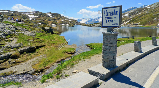
Using San Bernardino, a village at 1636m in the southwest of Grisons canton, I had a look at temperature and rainfall data back to 1999 to see what patterns were present. The figures confirm that some years see metres fall while others have barely enough to cover the pistes.
Temperatures, meanwhile, show a general upward tick from 2005-06.
While the above graphs show typical variability they don’t reveal much about month to month conditions.
Closer scrutiny of the data shows that early season dumps of over 30cm, the kind that really get the snow bases going and keep the earth below chilled for a long season, are becoming rarer. Indeed, apart from a blip in 2013/14 there have been no big early season dumps since 2009/10. The seasons are taking much longer to get going.
As the second graph shows big dumps of snow are happening later in the season. If there is not already a decent snow base these snowfalls can thaw much faster because spring sunshine has already warmed the ground.
Another way of trying to find how the climate has changed is to look at how many ‘ice days’ there were in a given period – ice days are when the maximum temperature reaches -0.1C or lower over 24hrs.
The graph below shows the past three years have been fairly constant though this season’s total of 83 is 37 days fewer than the highest total in the series, 2005-06 which clocked up 119 days.
I’ve visited many resorts in the Alps which, obviously, will be affected differently by the changing climate – the range of microclimates in the Alps is staggering.
In conclusion, considering the data and my experience, I’d say that though the Alps have definitely warmed the variability and ebb and flow of the climate means it is impossible to say with confidence that by the end of this century the slopes won’t be covered in the white stuff.
I chose San Bernardino because it is fairly central in the entire Alpine range and is also the most local SYNOP station I can find to the Valtellina range that I have been visiting most years since 1981. Any climatologists reading this would point out that my data range does not stretch back the necessary 30 years to make a judgment on the stats. If anyone can point me to a site that offers data back to 1980 I would happily update my figures and graphs.
My trip this year to Madesimo, 8 miles as the crow flies from San Bernardino, was timed just right for a dump of snow in February that followed weeks of dry weather.
Temperature inversions were seen in February (above). Snow was only deep enough to descend Madesimo’s Canelone run, reached by the Groppera lift to 3,000m once February snows had arrived
The area has enjoyed some epic snowfalls over the years including 2013/14 when many found themselves snowed-in following a 2m dump of snow. The first of many snowfalls during what was an epic season.
I spent last weekend in the Lake District, on Saturday ascending both Scafell and the Pike, England’s two highest mountains.
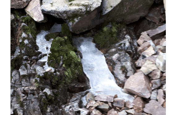
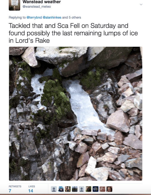
The 964m Scafell, though lower than the Pike, is a much more technical ascent with hard to negotiate gullies, among them Lord’s Rake, where I discovered three lumps of icy snow. My findings, that I later Tweeted, attracted the attention of Iain Cameron, who, with a team of volunteers, maps and measures all British snow patches that survive through the summer.
I’ve read about Iain’s findings in the Royal Meteorological Society‘s journal Weather but to find one of these surviving patches myself enabled me to empathise just why he and others find the task of mapping and measuring them fascinating, a sort of first-hand insight into how the UK’s climate varies from year to year.
On descending from Scafell I thought I’d seen further patches lower down but these turned out to be melted puddles on the moorland that were reflecting white against the bright sky.
It was a cracking weekend weatherwise. Though the wind on Sunday was fairly brisk at the top of Hellvellyn it didn’t impact much on the conditions. Two dry days in a row with excellent visibility are rare at any time of year in the Lakes. I can’t wait to return.
The driest April since 2011 was also the seventh driest in a local record going back to 1797. Just 4.3mm fell, nearly half of which was recorded on the final day.
An ‘absolute drought’ that began in March coincided with the month; a run of 26 days with a daily total of <0.2mm! Dry early springs seem to be becoming a pattern in this area with eight of the last 11 Aprils being notably dry.
Though the mean temperature for April finished a fraction above average – 10.6C is 0.8C above average – it was a month of two halves. The month started warm with the temperature peaking at 25.4C on the 9th – Sunday of what was a warm weekend in London.
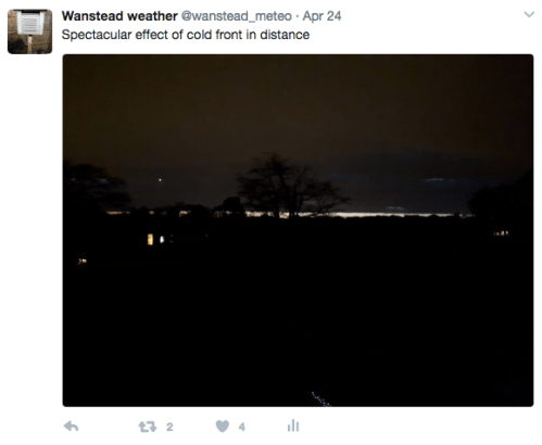
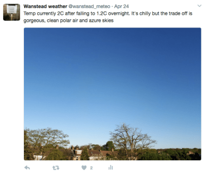
A polar low on 24th brought an unseasonably cold end to the month with cold days and night frost. Thunder was recorded on 26th and was accompanied by <5mm hail.
The total sunshine hours were just above average: 178.4 hours is 111% of the 1981-2010 average.
The wettest day occurred on the 30th with 2mm.
Air frosts: 1, Ground frosts: 7
Looking ahead, I think May will be another slightly milder than avrage month and continuing much drier than average.
Here follows the full weather diary for April. To view full stats follow this link:http://1drv.ms/1kiTuzv
1st: Cloudy into the late morning before some cloud breaks appeared. Brief shower and some warm sunshine but cooler than lately. Cold in early evening and cloud breaks overnight.
2nd: Sunny with variable cumulus. Variable cloud through the day and chilly overnight
Sunny with bubbly cumulus. 3rd: Cloudy but with bright breaks and blue sky in distance.
4th: Sunny and pleasant early with bubbly cumulus – this lasted all day.
5th: Sunny with just a few cumulus.
6th: Sunny with just a few wispy cumulus floating around, slight haze.
7th: Sunny and gin clear.
8th: Sunny spells with a few cumulus. Much cooler.
9th: Sunny with some cirrus and cumulus.
10th: Sunny though with lots of cloud at times.
11th: Sunny start then clouded over then sunnier again with cloudier periods.
12th: Early sunny spells, the cloud thickening by 11.30pm to leave a mostly cloudy afternoon. 13th: Cloudy though high base made it seem bright. Feeling chilly. A shower overnight.
14th: Bright start though with plenty of cloud around. Clear spells overnight.
15th: Sunny early though cloud increasing – a very light shower at 2.15pm.
16th: Cloudy, dull and cool. Some brightness at 2pm but then cloud thickened and breeze freshened to leave a cold afternoon.
17th: Sunny with variable cloud – clear overnight with ground frost.
18th: Sunny with broken cloud to start.
19th: Sunny start but clouded over, then sunny intervals.
20th: Cloud and mild all day.
21st: Very light drizzle to start then heavy cloud. Drizzle turned to light rain in Beckton but dry in Aldersbrook.
22nd: Bright start with broken cloud.
23rd: Bright early with patchy cirrus and altocumulus then completely cloudy and chilly. 24th: Some spots of rain around before moderate shower arrived at 5pm with 0.54mm falling.
25th: Sunny, clear start in polar air before cloud bubbled up around 10.30am. Then sunny spells – dew point stayed around or below freezing all day.
26th: Overcast and chilly with a cold breeze.
27th: Sunny, frosty start but cloud quickly bubbling up. Felt chilly.
28th: Mostly cloudy with the odd sunny spell
29th: Bright start but quickly turning cloudy
30th: Sunny early but gradually clouded over with rain at 1am. This stopped around 2am with small fall before 9am.
Lack of rainfall and a broken pump have been cited by City of London Corporation as the main reason for the shocking levels of the ponds through the park.
The Ornamental Water by the Grotto is virtually dry. Images courtesy of Ralph Potter
The plight of the water courses has been well documented of late; a press release from the Corporation explains the catalogue of issues hampering efforts to address the problem. Closer scrutiny of these reasons, however, suggest that too much is being blamed on the weather.
A study of local rainfall back to 1981 suggests that though the ground water replenishing season (October 1st – April 24th) has been dry it is by no means out of the ordinary.
As you can see from the graph the rainfall here has gone up and down like a yo-yo and 2016-17 is only the fourth driest period: 1991-92, 1995-96, 1996-97 and 2011-12 were drier.
The Corporation’s press release states: “2015-16 was a helpfully wet period for us…”
Wrong. 2015-16 was average. And if you consider annual rainfall 2015 saw 92 per cent of average rainfall recorded; 2016 was 93 per cent – placing 58th and 66th in driest years since 1797. Nothing out of the ordinary.
“2016-17 has, however, been an especially dry period with below average rainfall since Spring 2016.”
Wrong. See above detail. There have been three drier periods since 1981. And since March 2016, only half of the months have been notably dry, a period that included the third wettest June since 1797.
“January to March 2017 has seen roughly 50% less rainfall than average”
Wrong. January to March rainfall was 94% of the 1981-2010 average
April has been dry, and could be among the top 5 driest back to 1797, but it seems the Corporation are trying to blame nature instead of years of neglect on their part.
The past months have seen much of Heronry Pond dry out. Image by Ralph Potter
The situation is in stark contrast to CoL’s other open space, Hampstead Heath, which has recently seen the completion of a £23m project to make safe the ponds there. CoL has deep pockets yet they have dithered for years over spending £25,000 to renovate the Coronation Bridge – and offer the people of Ilford a route into the park.
Figures released by CoL show it has only invested £1.23m in Wanstead Park over the last five years, compared with £50m spent in Hampstead Heath.
We are constantly told that problems in the park are ‘in hand’ yet progress on anything is painfully slow – and action to repair the pump has sadly come too late for much of the wildlife on Heronry Pond.
People from far and wide use Wanstead Park – they really deserve better!
You can view City of London Corporation’s press release here
The mean temperature in March 2017 was the mildest in a local record going back to 1797.
A complete absence of air frost was mirrored in the mean which finished 10.5C, 2.8C above average and 0.3C higher than the previous record set in 1997.
The record temperature was probably down to notably mild air masses through the month as the total sunshine hours were about average, 107.2 hours is 99% of the 1981-2010 average.
The warmest day occured on the 30th with a high of 21.6°C in Wanstead, the warmest March day for 5 years.
Rainfall was very sparse, just 21.3mm were recorded, that’s 52% of average – a pattern that seems to be becoming more frequent; four of the last six Marches have been notably dry.
Sunshine was average. Over 107.2 hours were recorded, 99% of what we can expect to see during an average March.
The wettest day occurred on the 22nd with 5.8mm.
Air frosts: 0, Ground frosts: 1
Here follows the full weather diary for March. To view full stats follow this link:http://1drv.ms/1kiTuzv
1st: Sunny start, the sky gradually filling in with light rain at 3pm and into the evening. A windy night.
2nd: Sunny and blustery start, clouding over with some light rain in afternoon / evening. Drier overnight before area of light rain moved in at 0730z.
3rd: Cloudy start with light rain late morning. Feeling cold.
4th: Cold and cloudy with brief showers in the afternoon and overnight.
5th: Light rain at 9am and during the morning, briefly clearing at 10.30am before heavy showers moved in through the afternoon. Some warm sunny intervals in between. Showers into the evening until 10pm.
6th: Sunny start with just a few clouds around.
7th: Bright start with decreasing cloud to leave sunny late morning. Variable cloud through the afternoon. Rain at 00.50 until 0144.
8th: Light rain between 9 and 11am then showery though mostly light. Mild.
9th Sunny start though tending to cloud in late afternoon. Feeling mild.
10th: Cloudy with a burst of light rain at 10.30am.
11th: Bright, hazy start and feeling mild. Very quiet weather – pleasant in the garden.
12th: Cloudy with drizzle early afternoon
13th: Sunny start with a few cirrus, cloud gradually increasing but staying mostly sunny.
14th: Cloudy, mild and boring start – boring and cloudy all day.
15th: Misty start, quickly clearing to leave a glorious sunny day and pleasant.
16th: Sunny and clear up to 12 noon, then haze and cumulus pushing in and gradually thickening up. Light drizzle between midnight and early hours as cold front pushed through.
17th: Sunny but hazy start, this haze thickening through the morning. Feeling noticeably colder with patchy drizzle – felt quite inclement in the evening.
18th: Bright and breezy start. Then mostly cloudy with odd patch of drizzle.
19th: Cloudy, breezy with odd drizzle patch. Sunny intervals late morning and into the afternoon before clouding over in evening. Moderate rain at 1am.
20th: Cloudy and breezy start. Heavy showers spreading in with brief stair rods at 3pm, then clear and much cooler overnight.
21st: Sunny with well scattered cumulus.
22nd: Cloudy, dull and feeling cold in the wind. Showery rain, this turning heavier into the evening and to 1am.
23rd: Cloudy and breezy, some sun mid afternoon which felt warm.
24th: Cloudy, chilly and windy morning.
25th: Sunny and clear but with bracing easterly wind – pleasant outside the wind in the sun.
26th: Sunny and much more pleasant than yesterday with lighter wind.
27th: Cloudy and cold to start, the cloud breaking to long sunny periods that led to a pleasant afternoon. Cloudier overnight with cloudy, chilly dawn.
28th: Sunny, gin clear start. Cloud began building after noon with sun becoming ever more scarce. Light rain late evening and overnight.
29th: Cloudy and mild
30th: Sunny, though hazy start with lots of alto cumulus
31st: Cloudy and dull with brief drizzle at 9.30am. Cloud slightly less heavy at noon.
The unearthing of an ancient Egyptian statue, initially thought to be of the pharaoh Ramses II, in a Cairo suburb earlier this month reminded me of the mysterious stone that was discovered in Wanstead Park in 2014.
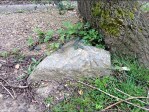
The mystery stone on the banks of Heronry Pond
The granite object, discovered partly buried in undergrowth on the banks of Heronry Pond, was initially thought to be part of the long-lost pyramidion (or capstone) of Tia, overseer of the treasury in the time of Ramses II, from his tomb at Saqqara in the Aswan region.
Though tests made last year at Reading University suggested otherwise the fate of the stone that once had pride of place in the American garden of Wanstead House remains a mystery.
The capstone was placed in the park as part of a landscaping project in 1784. Humphry Repton, the landscape gardener who devised plans in 1813-18, described Wanstead Park as “one of the most magnificent places in this country”.
Unfortunately, owner William Wellesley Pole’s debts caught up with him and the estate’s riches were sold off at auction, including the intriguing stone which was labelled Lot 279.
The catalogue of the 1822 auction
The auction on June 10th coincided with the hottest day of 1822 with the temperature peaking at 92°F. Evening thunderstorms brought some relief but the capstone remained unsold.
A catalogue of the 30-day event showed that Lot 279 was the last item to be sold, being bought by the auctioneer himself who immediately gave it to his son-in-law to display in his garden at Tamworth Castle. There is no evidence, however, that the stone ever reached Tamworth.
Though rainfall during the summer of 1822 was average much of it fell in cloudbursts. Luke Howard’s records in nearby Stratford for June and July reveal many days with maxima well into the 80s and destructive thunderstorms with deadly lightning and hail, some of which measured three inches in diameter.
Archaeologists at the dig in January 2015
It is possible that faced with transporting a very heavy lump of granite some 135 miles on a horse drawn cart on unmade, waterlogged roads those charged with the task instead quietly slid the stone into one of Wanstead Park’s lakes.
Ralph Potter, a member of Friends of Wanstead Parklands, has been following the story of the stone since it was discovered. He explained the reason behind why he thinks the stone’s origin is inconclusive: “Probably the world’s most eminent authority on stone from the Aswan quarries has declared, based on photos alone, that the stone does not originate from Aswan. On the other hand we have an eminent petrologist who within minutes of seeing the stone declared it almost certainly came from the quarry complex at Aswan.”
*A full history of the mystery of Lot 279, written by Chris Elliott, can be found here
**A chronicle of Wanstead Park, written by Alan Cornish, can be found here.
***The statue pulled from the mud in a Cairo suburb is thought to be most likely the first king of the 26th Dynasty of Egypt — Psamtek I .
Wanstead House (Wikimedia Commons)
Luke Howard’s entries in the Climate of London at the end of July tell of a very stormy period of weather
The period after the vernal equinox in 1952 was anything but springlike.
This chart shows the Synoptic setup at 1800h on 29th, the peak of the blizzard with F5 – F6 easterly winds, courtesy of the Met Office
A cold easterly airflow on March 29th and 30th 1952 affecting the southern half of England brought heavy snow whipped into drifts up to 6ft deep in parts of the Chilterns.
According to the Royal Meteorological Society’s weather log the snow varied from 3 to 6 inches and reached 10 inches at Northolt.
Squally winds, which gusted to 60 mph, blocked 330 main roads across the south. In places the temperature on the 29th remained below freezing all day – the snowstorm was probably the worst to affect southern England in late March since 1916.
The wintry weather followed a dry and fairly non-descript winter and must have been quite a shock at the end of what had been a fairly mild March.
Bernard Burton, of Wokingham, has a clear recollection of the event: “I remember the day very well as the Oxford/Cambridge boat race was held that afternoon. I was 14 at the time, and my brother-in-law gave me a ticket for a place on a launch to watch the race.
“My home was in Tooting at the time, and I took the bus to Westminster pier to catch the launch. I recall sitting upstairs on the bus with a thick layer of snow covering the front facing windows, but the roads and pavements were mainly slushy.”
Bernard, who runs Wokingham Weather, added: “I then spent one of the most miserable afternoons I can recall. There was a ‘lounge’ on the boat, which was warm, but was also full of diesel fumes and was very noisy. I alternately stood outside on the deck until the cold got too much, or went below for warmth until the fumes got the better of me.
“I recall bleak views of London with snow on roofs, in a poor grey afternoon light, but I think it was mainly dry at that time, although there may have been slight sleety rain.
“The boat race itself was a close one, but the crowds that usually lined the banks of the river were absent, just a few hardy stragglers, and by the time of the race I had a headache, probably brought on by the fumes. For my part, I couldn’t wait to get back to Westminster and back home to thaw out.”
John Hall, who was three at the time, said: ” I, sadly, don’t have any memory of it at all. That’s in spite of the fact that we apparently moved house from Cranleigh to Effingham (about 15 miles away) on the day of the blizzard.
“According to my father it snowed all day but the following day – which he reckoned was the 1st of April – the weather was glorious and all the snow was gone by noon. I don’t think his memory is quite in accordance with the facts, but of course that’s common with memories of past weather.”
The snow didn’t last long. March 31st saw temps rise to 5C; much of the snow had melted in the strong spring sunshine by April 1st. By the 3rd an Atlantic ridge of high pressure had moved in, raising temperatures to over 10C.
Stats for Kew suggest there was 21cm of level snow
1952 produced two more weather shocks. On August 15th and 16th over 220mm of rain fell on the hills above Lynmouth, Devon, leading to flash flooding of the village and the loss of 34 lives.
Months later, a large anticyclone during the last of five days of December produced the notorious ‘pea souper’ fog that contributed to the death of thousands of Londoners. This fog, initially freezing, became very dense and was directly responsible for the Clean Air Act enabled in 1956.
You can find an analysis of the unfolding pattern that produced the blizzard here. And here’s Xmetman’s take on the event.
A cold spell that saw a thin temporary covering of snow wasn’t enough to stop February 2017 from finishing mild. The mean temperature of 6.9C was 1.6C above the 1981-2010 average, the mildest February for three years.
The 20th saw the warmest February day in 13 years recorded, the 17.5C reached was marginally cooler than the 17.9C recorded on February 4th 2004.
Rainfall of 31.5mm was 80% of average – the driest February for 4 years. It was a dull month, some 44.6 hours of sunshine were recorded, just 61% of average, the dullest for 5 years.
The wettest day occurred on the 26th with 9.2mm.
Air frosts: 2
Ground frosts: 8
Snow falling: 4
So what has March got in store weatherwise? My long range forecasting method suggests the most likely scenario to be something rather cold waverage to slightly below rainfall
My February outlook for temperature, rainfall and sunshine was poor again.
Here follows the full weather diary for February. To view full stats follow this link:http://1drv.ms/1kiTuzv
1st: Cloudy with light rain late morning. Remaining cloudy into the afternoon and overnight with further light shower before obs time.
2nd: Cloudy and becoming breezy. Some intermittently light rain then cloudy. Broken cloud overnight.
3rd: Bright start with sunny spells developing – feeling warm in the sun. Cloud built up afternoon with rain at 4pm and 6pm. Rain at 8am.
4th: Light rain to start then bright spells late morning. Feeling chilly.
5th: Misty start and foggy out toward Epping. Some bright spells though mostly cold and cloudy. Broken cloud overnight with frozen dew at dawn.
6th: Sunny start with just a few wispy cirrus around. Clouding over after noon with rain in evening, heaviest at 8.45pm with bursts through the night. Min temp was at 9am yesterday.
7th: Cloudy, calm and damp start. Then clearing in afternoon for some mild sunny spells.
8th: Cloudy start and feeling really cold. Thick stratus cloud remained overnight – snow grains seen just before obs time.
9th: Cloudy and dull, snow grains seen. Mostly drizzle through the day.
10th: Dull and raw with occasional drizzle, sleet and snow grains falling all day and through the night – temporary dustings.
11th: Very light snow falling at 9am.
12th: Light snow at 9am with 1cm settling at Stanstead. Then cloudy and cold all day.
13th: Sunny start with sunny spells, clearance at noon.
14th: Cloudy start with complete clearance at noon. Then variable cirro cumulus.
15th: Cloudy start and cloudy all day with some rain.
16th: Cloudy start breaking to sunny intervals afternoon.
17th: Cloudy start breaking to sunny spells at 10.30am, long sunny spells and mostly clear overnight.
18th: Cloudy start with complete clearance after noon – cloudier spells overnight.
19th: Bright start but clouded over. Some drizzle at dusk.
20th: Cloudy start but sunny spells developing mid morning. Date record broken and warmest February day for 13 years.
21st: Cloudy and mild all day. Breeze picking up in the evening and into the night.
22nd: Cloudy and breezy start, the wind increasing through the day with occasional light drizzle. Some squally winds overnight.
23rd: Cloudy but with cold front clearance coming through at obs time – sunny spells thereafter but with squally winds – these increasing through the day with damage reported and trees down – a woman killed in Wolverhampton from flying debris.
24th: Sunny periods and feeling warm though shade felt cold. Early ground frost before cloud moved in – burst of rain in early hours.
25th: Cloudy and miserable with some rain in the late afternoon.
26th: Cloudy and miserable all day.
27th: Cloudy start but moderate to heavy prolonged showers moving in from 11pm. A miserable day with limited brightness.
28th: Sunny, gin clear start but with cirrus building frost west. Rain at 2.45pm, sporadic through the rest of the afternoon / evening.









 I’ve read about Iain’s findings in the

 3rd: Cloudy but with bright breaks and blue sky in distance.
 13th: Cloudy though high base made it seem bright. Feeling chilly. A shower overnight.




You must be logged in to post a comment.