Tag Archives: rainfall

April 2016: rather cold and thundery

April 2016 has seen more occurrences of thunder than we can expect during a typical July.

radar hail
About an inch of hail collected on borders in gardens in Plaistow during a thunderstorm on 29th. This stuck around for over an hour thanks to the low humidity

A persistent flow of unstable Polar maritime air, coupled together with strong sunshine, provided the perfect ingredients for some really beefy showers.

The mean temperature of 9C was 0.8C cooler than average, the coldest April for three years and in stark contrast to the previous two Aprils that were mild and very dry. Air frost, notable for its absence in the previous two Aprils, returned with four incidences where the temperature dipped below freezing

Apart from a dry slot in the third week rainfall was fairly steady: 52.5mm is 124% of average for this area. It was the wettest April for four years.

bracka20160415
A depression on 15th led to the wettest 24hrs of April

Sunshine was just below average. Over 153 hours were recorded, 96% of what we can expect to see during an average April.

The wettest day occurred on the 15th with 15.9mm, rain associated with a depression that ran along the Channel coast out into the North Sea, a system that heralded the colder pattern that defined the rest of the month.

Air frosts: 4, Ground frosts: 12

So what has May got in store weatherwise? The models on the 1st suggest that rather warmer weather will develop as we finally lose the northerly-sourced airflow and low pressure across the UK.

hail radar
The radar on 29th shows a thunderstorm right over Plaistow to the south of Wanstead

Low pressure to the NW will become influential with strong and milder WSW winds driving wind and rain bearing fronts east and SE across the UK late on Sunday and Monday. A bright and brisk NWly flow with sunshine and showers then looks likely to be replaced by a ridge of high pressure and drier weather. It will begin to feel quite warm in any sunshine across the south from midweek.

Beyond that the outlook is uncertain though it appears warmer, if changeable, conditions will prevail.

Beyond the grasp of the models my long range outlook method has conflicting signals. The highest probability is 32% for something rather cool. Average is 28% while rather mild comes in at 20% probability. Something cool comes in at 12%, while mild is 8% probability. Both cool and very mild have a probability of just 4%.

A wetter than average month looks most likely at 48% probability. Sunshine probably about average.

So to sum up: Mean: 12.8C (0.2C below average), rainfall 58mm, sunshine 179 hours.

My April outlook for temperature was good. I predicted a mean of 9.2C (outcome: 9C). Rainfall was also good: 57mm (outcome: 52.5mm). Sunshine also good: 149 hours (outcome: 153.9 hours).

Here follows the full weather diary for April. To view full stats follow this link:http://1drv.ms/1kiTuzv

1st: Sunny start though lots of haze around from late morning.
2nd: Sunny until 2pm before cloud then light rain spread in – this lasting into the evening.
3rd: Sunny start with hazy cumulus building through the day.
4th: Bright start though lots of cloud around. Some gin clear spells of sunshine.
5th: Sunny start though with variable cloud through the morning.
6th: Drizzly start, giving way to sunny spells and showers.
7th: Cloudy after recent light rain. Windy and cold. Some heavy showers mid to late afternooon with flash of lightning and thunder at 4pm and hail >5mm.
8th: Bright start though with much cloud around. Some brief sunny spells and v light showers.
9th: Cloudy, damp start after morning rain. This broke to sunny spells at 1pm ish. Cloudy again later but clearing at dusk to allow a frosty night.
10th: Sunny start but soon turned hazy with keen, cold SE wind building through the day.
11th: Cloudy start but brief brightness early afternoon. Rain at 2.15pm – this lasted until 5pm. More rain in the early hours, heaviest just before 5am.
12th: Bright start though hazy with lots of cirruo stratus. Clear and cold overnight.
13th Glorious sunny start and warm in the sunshine. Some patchy cloud at times. More cloud bubbled up late afternoon with a shower at 8pm and midnight. Clear and cold overnight.
14th: Sunny start though with much more cloud at times to 2pm. Showery rain in the evening lasted through the night.
15th: Cloudy with rain at 9.45am until 10.15 then turned a bit brighter before cloudy again at 11.45am. Rain set in at 12.30pm with thunder at 1.07pm then rain on and off into the evening. Clearing overnight and cold.
16th: Cloudy and cold start. Stayed cloudy all day with brief light rain shower. Cold and frosty overnight.
17th: Sunny, gin clear start with cloud gradually bubbling up. Sunny periods throughout the day.
18th: Sunny start with cumulus bubbling up.
19th: Mostly sunny start but then turned very cloudy. This cloud cleared just before noon.
20th: Sunny, clear start with just a few cirrocumulus drifting around during the day. Cold wind.
21st: Bright start but much cloud around. Some spells of hazy sun through the afternoon.
22nd: Cloudy, cold feeling start. Rain by 5pm, this heavier than expected. Next day dawned clear but cloud soon bubbled up.
23rd: Sunny start, cloud bubbled up with a shower at 12.25pm, clearing by 1pm. Early rain on 24th before obs time.
24th: Bright start, cloud bubbled up with light shower at midnight.
25th: Cloudy, cold start with lots of Arctic cumulus. Showers soon arrived that were mostly sharp but brief and heavier in the east. These cleared to leave a cold, breezy night.
26th: Sunny start but cloud quickly bubbled up. Some heavy showers of soft hail with odd snow flake. Thunder at 2.45pm.
27th: Sunny start though cloud quickly started building with snow and soft hail at 12.30pm. Further showers at 1712 and 2330. Clear, cold and frosty overnight.
28th: Sunny and mostly clear up until  12 noon.
29th: Sunny start though cloud quickly bubbled up. Some very heavy hail in Plaistow with an accumulation of one inch – this hung around for a while due to the low dew point and low humidity – less in Wanstead. Thunder and lightning too.
30th: Sunny, clear start though cloud began to bubble up. Felt cold in the wind as it became overcast last afternoon. Cleared overnight to give frost.

bluebells
Another superb display of bluebells burst into life in Chalet Wood, Wanstead Park, this month

March 2016: cool and wet

With the meteorological winter over the first month of spring saw the weather return to its modern type: cooler than average just when most people are looking for warmth.

squalllengthofuk
The squall of March 26th ran the length of England

The mean temperature of 6.7C was 1C cooler than average, the coldest March for three years and the first month more than 1C below average since last September.

The wet end to the month tipped the rainfall statistic well above average: 60.3mm is 148% of average for this area. It was the wettest March for eight years, notable because of a 14-day dry spell during the middle part of the month.

Sunshine was just above average. Over 116 hours were recorded, 107% of what we can expect to see during an average March.

The wettest day occurred on the 27th with 14.4mm, rain associated with blustery weather fronts from Storm Katie.

Air frosts: 7, Ground frosts: 14

So what has April got in store weatherwise? April is often a month when we can see huge swings in the weather from day to day as the natural warming of the atmosphere competes with the decaying coldness of northern latitudes.

squallonsynop
The squall of March 26th ran the length of England

This often results in big showers and vast temperature differences not only day to day but between night and day too. All of the above is going to be on offer over the coming few weeks if the model output on the 1st is correct. A warmer phase will begin the month as winds switch southerly, drawing warmth from Spain. However, with low pressure close big showers and outbreaks of rain should be expected. Then as the low switches to the NE of the UK the door opens next week for colder NW winds with further rain or showers and chillier air. A lot of output strengthens this northern sourced air through the second week and with low pressure never looking likely to be far from the UK we will be looking at lots of showers and spells of rain.

Beyond the grasp of the models my long range outlook method suggests the April mean will be average or just below at 60% probability. Rather cold comes in at 20% while cold has a probability of 20%. There appears no chance of something mild.

squall26032016
The squall of March 26th ran the length of England

A wetter than average month looks most likely at 40% probability. Sunshine probably about average.

So to sum up: Mean: 9.2C, rainfall 57mm, sunshine 149 hours.

My March outlook for temperature was good. I predicted a mean of 5.9C (outcome: 6.7C). Rainfall was way off: 31.6mm (outcome: 60.3mm). Sunshine also out: 68 hours(outcome: 116 hours).

Here follows the full weather diary for March. To view full stats follow this link:http://1drv.ms/1kiTuzv

1st: Drizzly start turned to steady rain at 10am – this lasting past lunchtime but drying up to leave a cloudy afternoon. Very sharp squall blew threw at 2am with brief intense rainfall.
2nd: Bright start but soon turned very blustery and showery. Brighter after 3pm but cold as dew point fell away.
3rd: Sunny, cold start. Cloud bubbling up late morning.
4th: Sunny, gin clear start. Cloud bubbled up through the day. Clearing in the evening to leave a very cold early hours. Light rain moving in at obs time.
5th: Cloudy start with small area of rain around 10pm. Brief brightness at noon before more light rain moved in. Clearance again at 3.30pm. Small hail <5mm at 5pm. Clear spells overnight.

squallfall6c
The squall of March 26th ran the length of England

6th: Sunny, cold start. Coud bubbling up late morning.
7th: Sunny, cold start with light winds. Variable cloud but feeling cold, especially so overnight.
8th: Cloudy, calm and cold start.
9th: Very light drizzle am before briefly brightening up. Heavier rain pushed in between noon and 2pm. More rain at intermittent periods into the evening.
10th: Cloudy until 2pm. Cleared at dusk to leave a frosty, cold night with thick fog patches on Centre Road.
11th: Sunny start with early mist clearing. Variable cloud through the day. Clear spells up to midnight but then tending to cloud over.
12th: Cloudy start tending to brighten up though sunshine remained mostly wintry.
13th: Cloudy start quickly cleared to leave sunny morning. Pleasant until a keen N’ly wind set in.
14th: Bright start with cloud quickly breaking, cold wind.
15th: Cloudy and dull start. Mostly cloudy through the day.
16th: Bright start but cloud filling in by 10am. Mostly cloudy all day
17th: Sunny and clear until 11am – patchy cirrus thereafter.
18th: Cloudy, cool start – the cloud lasting past 12 noon.
19th: Cloudy start – very brief drizzle. Brief brightness just before 10am then cloudy.
20th: Cloudy start brief sunshine at 10am-ish before cloud spilled across. Another clearance at 11am before cloud returned for afternoon.
21st: Cloudy until brief sunny spells at 10.30am. Much milder for a time before a mostly cloudy afternoon.
22nd: Mostly sunny all day with just a few cumulus.
23rd: Cloudy all day
24th: Cloudy, chilly start. Rain spread in by 1pm and turned heavier in the evening, clearing around 3am to showers. Sunny dawn.
25th: Sunny start with just patchy cumulus
26th: Cloudy with intermittent light drizzle. Very heavy squall at 6pm brought 5C fall in temperature.
27th: Sunny start but with some very dark clouds around. Squally winds and showers thereafter at 11.30 and 2.30pm.
28th: Cloud and rain to start and very windy due to Storm Katie, becoming fine by mid afternoon though heavy showers moved in.
29th: Bright start with cumulus dotting the sky. Cloud thickened up during the day with heavy showers in the evening.
30th: Sunny start with fair weather cumulus doting sky – this lasting all day.
31st Sunny, misty start


February 2016: average contrast

Though it was devoid of snowfall February 2016 was average for temperature and sunshine and on the dry side.

broadstairs
On the 15th cold northerly winds brought sharp showers to the coast. A big swell was seen at Broadstairs allowing for some good surfing conditions

Some sharp frosts made for a couple of stunningly sunny days, “ski resort weather” the kind of days that were absent during the first half of winter after the super mild December.

Rainfall of 35.1mm was 90% of average – the driest February for three years. Mean temperature for the month was 5.4C, 0.1C above the 1981-2010 mean.

Sunshine was just above average. Over 79 hours were recorded, 108% of what we can expect to see during an average February.

The wettest day occurred on the 7th with 11.6mm.

Air frosts: 10

Ground frosts: 16

low
A rare Channel low but conditions weren’t cold enough for snow

So what has March got in store weatherwise? The late winter synoptic pattern could see the first snowfall above 1cm over the coming days and next week though amounts are likely to be small and temporary and restricted to night hours.

The pattern bringing this messy wintry mix is low pressure moving SE across the UK between now and the weekend each band bringing progressively colder air across the UK. Much of the precipitation will be showery although Friday looks more interesting as a secondary moving south brings cold N or NE winds. Models suggest next week will see high pressure from the west displacing this cold N. The timescale is very uncertain and it may be toward the second half of next week before the general theme of dry and settled conditions prevail. Frosts at night remain likely and daytime temperatures remain close to or a little below normal.

Overall the first half of March does not look like it will offer much in the way of spring weather.

My long range forecasting method suggests the most likely scenarios to be rather cold or cold, though both are only at 33% probability. Something average or below works out at 83% probability. The only mild indicator is for something rather mild at 16% probability.

squall
On the 15th cold northerly winds brought sharp showers to the coast. A big swell was seen at Broadstairs allowing for some good surfing conditions

A dryer than average month looks most likely at 66% probability. Something wetter than average works out at 34% probability.

Very dull conditions look most likely at 83% probability.

So to sum up: Mean: 5.9C, rainfall 31.6mm, sunshine 68 hours.

Taking all of the above into account perhaps the most likely scenario will be that the month will be predominantly anticyclonic with lots of gloom during the day and night frosts, varying in intensity.

So to sum up: Mean: 5.9C, rainfall 32mm, sunshine 67 hours.

My February outlook for temperature was good. I predicted a mean of 5.9C (outcome: 5.4C) with 31.6mm of rain (outcome: 35.1mm). Sunshine 68 hours (outcome: 79.5hrs)

Here follows the full weather diary for February. To view full stats follow this link:http://1drv.ms/1kiTuzv

1st: Cloudy, breezy start. Sunshine PM with nacreous clouds reported on east coast. Cold in a brisk wind.
2nd Cloud gave way to sunny spells around 11am – then feeling cold in a brisk wind.
3rd Cloudy and cold start then mostly cloudy with a cold wind.
4th Bright though mostly cloudy start. Cloudy through the day with odd spot of drizzle through the night. Area of very light rain gave about 0.1mm before 9am.
5th Cloudy with light drizzle up to 11am then briefly bright before more drizzle arrived.
6th Cloudy to start with odd burst of drizzle. Very windy and feeling chilly in wind. Rain arriving after 8pm.
7th Sunny start though cloud bubbling up after 11am and feeling cold in wind as dew point fell away. A very heavy, violent squall swept through at 2245z then blustery through the night.
8th Sunny start quickly gave way to squally showers which were mostly light. Strong winds into the afternoon with squally but light showers. Chilly overnight.
9th Cloudy and cold start, briefly clearing before noon before clouding over again.
10th Cloudy start though with some weak brightness lunchtime.
11th Mostly sunny all day and calm – warmth of the sun can now be felt. Just a few cirrocumulus. Stunning.
12th Bright start but cloud thickening. Day felt cold though as DP fell away.
13th Cloudy start with drizzle at obs time. Cold wind through to lunchtime and intermittent drizzle.
14th Bright, cold start with cloud increasing through the morning.
15th Bright, cold start with lots of wispy cirro-cumulus around. .
16th Stunningly sunny and frosty start. Just patchy cirrus through the day.
17th Cloudy through the day until 5.30pm when drizzle then rain set in.
18th Initially cloudy but then quickly brightened up. Sunny spells through the afternoon.
19th Sunny, clear and frosty start. Cloud began to build mid morning becoming overcast by noon. Light rain spread in about 4pm. Milder.
20th Bright start but cloud and wind quickly built. Light at times moderate rain fell through the afternoon – a thoroughly miserable day.
21st Dull, dry day up to 1pm. Very mild. Staying cloudy overnight with rain arriving at 5am, most falling until 7.30am.
22rd Drizzly start turned to a dull, overcast day
23th Cloudy with clearance at 11.30am. More cloud appeared to leave sunny spells. Much advection but cleared to leave frosty night.
24th Sunny, clear and frosty start. Lots of sunshine but quickly turned cold after dark with early frost. Cloud then wind lifted temperature though.
25th Bright start but quickly clouded over to become cold. Clearance in evening allowed temperature to fall quickly but cloud moved in and breeze picked up to prevent a sharp fall.
26th Cloudy, cold start. Brightening up to sunny spells by 1pm. Too much cloud overnight for a frost.
27th Bright start but became cloudy through the day with a cold easterly wind.
28th Cloudy start but some brightness around noon
29th Cloudy start but soon brightened up with long sunny spells before clouding in again early afternoon.

January 2016: average and wet

The coldest night in three years was recorded last month together with the first lying snow in January since 2013 – though you had to be up early on Sunday 17th to see it.

epping snow
Snowfall on the 17th was just over 1cm deep at High Beech. In Wanstead it was just a thin covering that was gone by midday

For anyone looking for ‘traditional’ winter weather it was pretty desperate stuff and seems a continuation of the mild winters of the past three years.

Apart from a mild final week much of the month was rather cold with a couple of sharp night frosts that affected many early daffodils that bloomed during the super mild December.

Rainfall of 65.8mm was 124% of average – very similar to last January’s total. Mean temperature for the month was 5.8C, 0.6C above the 1981-2010 mean. It felt far cooler, however, because the December mean was 5C above average.

high beechSunshine was just above average. Over 54 hours were recorded, 108% of what we can expect to see during an average January.

The wettest day occurred on the 10th with 11.6mm.

Air frosts: 6

Ground frosts: 18

So what has February got in store weatherwise? There is no sign of any longer term changes in the pattern of synoptics across the UK. All models continue to suggest a very volatile jet stream with resultant low pressure close to or across the UK for much of the first half of February.

new street
The snow on the 17th fell during the early hours of the morning

This week westerly winds will remain strong with severe gales in the north in association with Storm Henry over the next 36 hours. The current mild and damp conditions in the south should be replaced with colder, showery air moving south later on Monday, lasting into Wednesday. On Thursday another large warm sector will move up across the UK from the SW returning mild and damp conditions.

At the weekend all models show low pressure areas taking a much more southerly route across the UK with gales and wet weather. While no cold weather looks likely there may be incidences of very heavy and thundery showers. Only GFS on Monday is showing any hint of more settled, colder weather at the end of the period.

Using my long range method February is looking average, very dry and dull.

A mean of about 5.9C, just over average, is the highest probability at 71%. Something ‘rather mild’ comes in at 29% probability.

Rainfall is looking low: 15mm represents something 38% of average.

Sunshine totals will be low and it could be a dull month, around 60 hours of sunshine, that’s just 82% of average.

My January outlook for temperature good. I predicted a mean of 5.2C (outcome: 5.8C) with 59mm of rain (outcome: 65.8mm).

Here follows the full weather diary for December. To view full stats follow this link:http://1drv.ms/1kiTuzv


1st: Bright after sunny, clear dawn before clouding over with light rain. Rain at midnight.
2nd: Cloudy start after early overnight rain. Rainy spells and blustery throughout the day.
3rd: Drizzle to start then damp before more rain moved in at 11.30am – this fell intermittently through the day and evening and was often heavy.
4th: Bright, damp start after overnight rain. Some light outbreaks up to 2pm.
5th: Sunny, clear and cold start with contrails dotting the sky. Clouding over later with rain after 6pm. Misty around midnight.
6th: Bright, very damp start. Mostly cloudy with rain in the evening and overnight.
7th: Dull start with outbreaks of rain spreading in, some heavy and very blustery. Drying up after lunchtime though feeling cold. Cool overnight with frost on cars with a very brief shower on school run.
8th: Bright start though light showers around. Gradually clouding over. Clearer spells overnight and cool.
9th: Bright start though with plenty of cloud around. Showers, some heavy with small hail at 8.30pm. Clear spells overnight.
10th: Bright start after overnight rain. Cloud gradually decreasing to leave it clear at noon. Cloud returned after dusk and thickened up around 9pm. Heavy rain from midnight.
11th: Cloudy, damp and cold start. Some breaks after noon then clear spells overnight and cold.
12th: Sunny, cold start. Clouding over at midday to leave cold-feeling afternoon and overnight – too much wind for a frost.
13th: Bright, cold start but turning mostly cloudy. Rain in the evening and on ride home.
14th: Rainy. cold start, then cloudy with sunny intervals. Cold air digging in from midday.
15th: Sunny all day with just a few cirrus. Took a while for frost to form properly.
16th: Sunny, frosty start with just a few cirrus. Variable cloud and evening in London felt freezing. Some drizzle, this turned heavier and by 4am thick flakes were falling to give a thin covering. Some 1cm at High Beach during a bike ride.
17th: Cloudy start. Thin covering of snow (<1cm) thawed by lunchtime. Cloud built into afternoon to leave chilly evening.
18th: Bright start but sunshine was weak so felt cold. Mostly clear into the evening allowed for an early frost. A classic radiative cooling night until the early hours, assisted by a very gentle low-level flow off the continent where there were some very low dew points. Between 2am and 6am there was some thin, high-level cloud that drifted across, which stopped the radiative cooling. Warmth from the ground then briefly lifted the temperature until, once more the cloud cleared after 6am and allowed the temperature to fall again to its minimum of -5C at 0809z. There was also a little mixing of the layers of air between 2 and 6 which would also have had a cooling effect. Had it not been for the cloud I’d suggest that the low could have fallen to -6.2C, which would have been the coldest since February 2012 when it fell to -9.2C over full snow cover.
19th: Sunny all day with occasional alto-cumulus drifting across. Another cold night, the coldest in 3 years.
20th: Bright start with lots of scattered cumulus. Sunnier early afternoon and less cold. Another frost quickly forming after dark.
21st: Frost lifting quickly then cloudy with limited brightness throughout the day.
22nd: Cloudy start with rain arriving at 9.05am. Bursts through the day until early afternoon. Some brief brightness in the late afternoon.
23rd: Sunny, cool start. Clouding over with rain in the evening. Very mild.
24th: Cloudy start after overnight rain. Mostly cloudy with odd spot of drizzle though bright.
25th: Sunny, clear start though cloud bubbled up at 11am to leave mostly cloudy afternoon. Clear spells overnight and chilly.
26th: Cloudy and increasingly gusty up to midday. Some rain in the evening.
27th: Cloudy, blustery start.
28th: Sunny all day with just a few clouds around noon.
29th: Cloudy and breezy with some drizzle in the wind early afternoon. Report of 101mph gust on Shetland from Storm Gertrude. Wind seemed to strengthen at midnight before rain arrived.
30th: Cloudy and damp start after overnight rain. Sky soon cleared to leave mostly sunny afternoon.
31st: Drizzle in morning as warm front moved in.

Wanstead weather: 2015 review

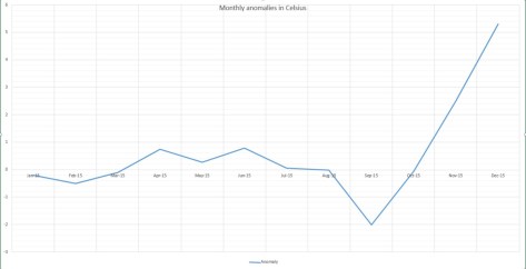
This year finished as the ninth warmest year on record – some 0.5C cooler than 2014.monthly anomalies

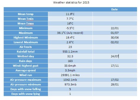
Every month of 2015, apart from September, November and December, was roughly average – the means being within +/-0.7 every month, bringing the mean temperature to 11.9C, 0.7C above the 1981-2010 average.

Rainfall was less remarkable with the year being dryer than average. The total of 553mm puts it as the 162nd wettest since 1797.

It was also a very slightly duller than average year with 1,433 hours of sunshine recorded. That’s 97 per cent of average, the 77th dullest since 1881 – the least amount of sunshine for 11 years.

weather stats for 2015

For a review of each month, click January, February, March, April, May, June, July, August, September, October, November, December.

To view full stats follow this link:http://1drv.ms/1kiTuzv


November 1940: London’s wettest on record

3:11:1940
The synoptic chart from 7am on November 3rd 1940 showed a deep depression crossing the country that brought over 40mm of rain to Greenwich Image: Courtesy of Met Office

November 1940 was the wettest on record for this area. Over 170mm of rain fell in Greenwich, beating the previous record set over a hundred years before in 1836.

Other areas of London were even wetter: Croydon was wettest with just under 196mm while Addington recorded just under 194mm, Bromley 179mm and Regent’s Park 175mm.

Nearly a quarter of the month’s rainfall fell on the 3rd. The total of 40.8mm is a daily November record that remains to this day. Indeed, throughout the month, there were falls of more than one inch (25.4mm) somewhere in the London area on four days: 40.8mm (3rd, Greenwich), 26.7mm (4th, East Ham), 26.4mm (11th, Camden Square), 27.4mm (13th, Southgate).

In Wanstead and Woodford the inclement weather coincided with a 6-day pause in bombing incidents during the Blitz. November was a very cyclonic month that probably hampered German air operations.

Another 6-day pause in the bombing happened after November 16th. When the Luftwaffe returned on Saturday, November 23rd, it was Wanstead that bore the brunt. At 4.12pm, as light was fading on a dull, dreary afternoon, high explosive bombs caused fires at and partly demolished nos 78 and 89 New Wanstead. A minute later another bomb ruptured water and gas mains in Spratt Hall Road. At 4.30pm a further high explosive bomb fell in the High Street, killing 4 people. The raid ended at 5.16pm as a bomb fell in Fitzgerald Road though this time there were no injuries.

By now the weather was beginning to quieten down though weeks of deep depressions with associated gales and heavy rain had taken their toll – many residents reported problems of Anderson bomb shelters being constantly flooded – but it was probably the design as much as the weather that was to blame.

As pressure built in the last few days of November the first frosts of winter arrived but the bombs returned. High explosive devices fell in Woodford New Road and Bunces Lane on the 30th, fracturing a water main.

To put November 1940 into some sort of perspective the average fall for the month in this area, with regard to the 1981-2010 average, is 59mm. The closest this area has come to matching the record was 2009 when 150mm was recorded and preceded a cold winter.

The following synoptic charts are for each day of November at 7am. All courtesy of the Met Office

Winter forecast 2014/15

OLYMPUS DIGITAL CAMERA
There is a higher chance of snow this year. The average for lying snow in Wanstead at 9am in winter is 6 days

Probabilities for winter for the London area would be a more apt title for this post but that’s not very exciting compared with the hyperbole published almost daily by the likes of the Daily Express.

Much has been written about the sources of their forecasts over the past couple of years. Splash headlines that promise Armageddon Arctic conditions or Biblical blizzards never seem to materialise. So without boring you further I’ll move on to my own views on how I think the next 90-odd days will unfold.

Taking into account more sophisticated methods than my own there seems to be a signal for something colder than last year – though that’s not saying much given that 2013/14 was the 11th warmest winter on record with NO snow falling observed in this area.

OLYMPUS DIGITAL CAMERA
Jack Frost could also be around more this winter than last

Though it was abandoned by the Met Office years ago I have decided to base my predictions more on analogues this year. I have a lot more data at my disposal – the series I use now extends past 1881 back to 1797.

The figure I arrived at, taken as an average of the closest matching autumn periods, is a mean temperature of 4.2C with rainfall totalling 156mm over the months of December, January and February – that’s about a degree colder than average and about average rainfall – though I think it could be less given that December is looking relatively dry on the current model output.

The probability of a winter with a mean temperature of between 3C and 4C is 33% – the most likely outcome – though this low figure emphasizes the mixed signals this autumn. With this in mind a winter similar to 1984/85 is possible which saw a brief cold snap at the end of December together with a two-week cold spell that began during the first week of January. There was also a 10-day cold spell during February of that winter.

iced anemTo try to add value to the above outcome I also had a look at the likelihood of this winter being as mild as last winter.

It has been noted in the past that mild winters often come in twos. I had a look back through the series to see if this was true.

The occurrence of two very mild winters in succession is 27/217 (12.4%). The occurrence of a very mild winter being followed by a very cold or severe winter is 16/217 (7.4%). So while, from these simple stats, another mild winter is more likely, it is not really high enough to consider over the average I  found in the first calculation made from straight autumn statistics.

A final fact to consider is just how mild and wet this year has been. Every month this year, apart from August, has been warmer than average by an average factor of 1.2. If December continues warm this year could possibly end as the warmest on record. However, it is also possible that nature is about to redress the balance.

Here is a link of my method to predict the coming winter.

winter 2014-15

* Forecasting models use probability on any given outcome. Millions of observations are fed into the Met Office database (and other countries’ weather agencies) every day. Supercomputers then crunch through this data to give probable outcomes. With the volatility of the atmosphere it is not surprising that certainty of any outcome often falls away rapidly. Forecasting has improved greatly in the last 20 years – though anything the models churn out beyond three to five days should be handled with caution. Long range models can give *some* idea of general trends for the months ahead – but changing just one variable can vastly alter an outcome at the end of the run.

* *Over the past few months I have been collating data for the area around Wanstead. This data is freely available from the excellent Met Office library and is emailed via Excel spreadsheet. Rainfall stats include a near-complete daily archive, stretching from 1961 to 2003, from City of London Cemetery . Sadly the rainfall station, along with many others, ceased to supply the Met Office after cuts were made shortly after the turn of century. Prior to 1961 I have used monthly figures taken at the Greenwich Royal Observatory stretching back to 1881. Though this is 6 miles away the difference in temperature between the two areas would be miniscule compared with rainfall data and so can be used. I use my own stats for the period after 2003.

http://benvironment.org.uk/post/36504022174/coldestwinterin100years


http://www.bbc.co.uk/blogs/paulhudson/posts/whats-behind-the-coldest-winter

September 2014: warmer and dryer than average

In terms of weather events September was a relatively quiet month save for the two thunderstorms that seemed to mark the Scottish Referendum as the results became apparent in the early hours of Friday 19th.

Clouds above could be seen developing rapidly at 2.30pm on 19th September

September 2014 was warmer than average; the mean temperature of 16.4C was 1.1C above average, making it the 16th warmest September since 1797: 1.6C warmer than last September, the warmest since 2011.

The month was marked with lots of dry, sunny days, the two thunderstorms on the 19th contributing 89 per cent of the rainfall for the month. It was dryer than average – the 44.8mm that fell is 86 per cent of what we would expect in a normal September.

Despite this it was only the driest September here since 2011.

The warmest day occurred on the 18th with 25.6C recorded. Most nights were warm though a couple of nights were chilly: 5.4C was recorded on 24th

Sunshine was below average with 126.9 hours recorded – that’s 91 per cent of mean. The sunniest day was on the 8th when 12 hours of sunshine were recorded. There were 2 days with thunder recorde.

To view full stats follow this link:http://1drv.ms/1kiTuzv


August 2014 – cool, wet and dull

Anyone hoping for a continuation of June and July’s hot weather would have been left sorely disappointed by last month which was characterised by frequent rain and the coldest August night for over 20 years.

A stunning example of sunlight illuminating the underside of cloud at sunset was seen mid-month

August 2014 was the first month this year to be cooler than average; the mean temperature of 17.2C was 1C below average, making it the 89th warmest August since 1797: 1.6C cooler than last August, the coolest for 7 years.

The month was marked with thunderstorms and heavy downpours, contributing to what was a much wetter than average month – some 76mm fell which is 152% of the monthly average and the wettest for 4 years.

The hottest day occurred on the 7th with 27.3C recorded – nothing special for August and a date that heralded the end of the hot spell during June and July.

A couple of nights were notably cool for August: 5C was recorded during the early hours of the 23rd – the coldest August night since 1993.

Sunshine was below average with 161 hours recorded – that’s 83 per cent of mean. The sunniest day was on the 3rd when 12 hours of sunshine were recorded. Throughout the month there were just 2 days with 10 hours or more of sunshine. There were 4 days with thunder recorded – the average for August is 3.

To view full stats follow this link:http://1drv.ms/1kiTuzv

Looking further afield there were many thunderstorms around the UK though many places missed out on the big downpours. It was yet another month where rainfall totals could vary greatly in the space of just a few miles.

On the 9th a station in Woodford Green recorded 24.4mm, double what fell in Wanstead. The legacy of TS Bertha coincided with the end of our extended hot spell – an excellent analysis of this storm can be found here.

There were some spectacular cloud formations not far from here. A particularly good one was seen in Witham. 

Squally storm line approaching Witham, panoramic shot!

Prolonged heavy rain on the 11th caused extensive flooding in Scotland.

On the 14th ‘Biblical’ flooding affected Lewisham in south east London.

On 25th a perfect curl could be seen on a depression centred off the west coast of Irleland. The rain associated with this low pressure brought the month's highest daily rainfall total: 23.4mm (the system bringing 27.5mm) - a thoroughly miserable Bank Holiday Monday where it rained ALL day, from 6am until 9.30pm. It was yet another example of how much even frontal rainfall can vary over a small area.
On 25th a perfect curl could be seen on a depression centred off the west coast of Irleland. The rain associated with this low pressure brought the month’s highest daily rainfall total: 23.4mm (the system bringing 27.5mm) – a thoroughly miserable Bank Holiday Monday where it rained ALL day, from 6am until 9.30pm. It was yet another example of how much even frontal rainfall can vary over a small area.

On 25th a perfect curl could be seen on a depression centred off the west coast of Irleland. The rain associated with this low pressure brought the month’s highest daily rainfall total: 23.4mm (the system bringing 27.5mm) – a thoroughly miserable Bank Holiday Monday where it rained ALL day, from 6am until 9.30pm. It was yet another example of how much even frontal rainfall can vary over a small area with St James Park recording 38.2mm. The top 30 totals for that day can be seen here.

sunset overlooking Wanstead Flats 2nd August

Looking even further afield four people were killed in a flash flood at an Italian festival early on in the month.


A dry or wet St Swithun’s?

St Swithun's reputation as a weather saint is said to have arisen from the translation of his body from a lowly grave to its golden shrine within Winchester cathedral, having been delayed by incessant rain for 40 days
St Swithun’s reputation as a weather saint is said to have arisen from the translation of his body from a lowly grave to its golden shrine within Winchester cathedral, having been delayed by incessant rain for 40 days

Legend has it that the weather on Monday will be the same for the next 40 days.

St Swithun’s day, if thou dost rain,
For forty days it will remain;
St Swithun’s day, if thou be fair,
For forty days ’twill rain na mair.

St Swithun’s Day is probably among the most well known of weather folklore – but, taken at face value, it is probably the most unreliable.

Since 1961 Wanstead has enjoyed 30 dry St Swithun’s Days (57%). From these the longest dry spell that followed was just 18 days, in 2000. On average, if St Swithun’s is dry, the weather stays fair for five days, with rain arriving on the 20th.

Another interesting observation is that the 40-day period that followed a dry St Swithun’s is on average 13% WETTER than if it rained on July 15th.

So what does this mean for the rest of July and the summer? Looking back at other years that have seen a mostly dry and warm pattern in the run up to St Swithun’s Day we should see a continuation of the mostly dry, warm and sunny conditions, perhaps with frequent thundery breakdowns, the first arriving on Thursday into Friday.

Putting superstition and singularities aside current weather models back this up.

Featured Image -- 1745St Swithun was born around 800AD and died on July 2, 862, at Winchester, Hampshire. According to historians he was fond of building churches in places where there were none. St Swithun, who was bishop of Winchester, was buried in the churchyard of the Old Minster at Winchester, where passers by might tread on his grave and where the rain from the eaves might fall on it.

His reputation as a weather saint is said to have arisen from the translation of his body from this lowly grave to its golden shrine within the cathedral, having been delayed by incessant rain for 40 days.

The basis of the St Swithun’s saying follows the fact that by July 15th summer weather patterns are already well established and tend to persist through the coming weeks.

In meterological terms the position of the frontal zone around the end of June to early July, indicated by the position of the jet stream, determines the general weather patterns (hot, cold, dry, wet) for the rest of the summer. Like a little stream in its bed, the frontal zone tends to ‘dig in’ shortly after the summer solstice.

As the path of our weather systems is controlled by the jet stream, a more southerly location of the frontal zone – as happened last year – is likely to bring unsettled, wet and cool weather. On the other hand, a frontal zone shifted further to the north – as is happening this year – will help the Azores high to build over western Europe, thus bringing dry and pleasant weather to the UK.

Other western European countries also have similar St Swithun’s day sayings – that follow the principle rule. In France they say ‘Quand il pleut a la Saint Gervais Il pleut quarante jours apres’ – If it rains on St. Gervais’ day (July 19th), it will rain for fourty days afterward.
In Germany the Siebenschlaefer or seven sleepers day (July 7th, after the Gregorian calendar) refers to the weather patterns of the following seven weeks.