All posts by wansteadmeteo

A blog that tries to make sense of how the UK's national climate translates into local weather for Wanstead and the surrounding regions of east London and west Essex. Check out my twitter feed @wanstead_meteo for local weather forecasts, stats, records and phenomena for the east London areas of Wanstead, Aldersbrook, Leytonstone and Stratford. And anything else weather

July 2016: rather warm and very dry

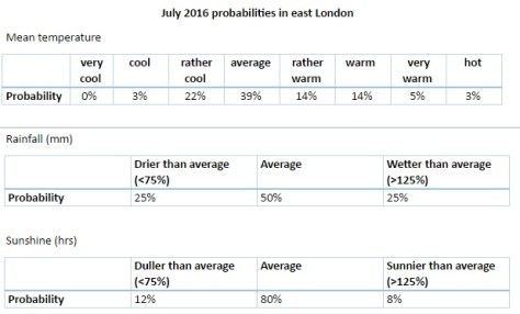
There was plenty of interest in the weather last month even though the overall stats suggest July 2016 wasn’t that remarkable.

july 9 sky
The sunset on July 9th was spectacular

Most notable was temperature: the warmest minimum on record for this area (21.1C) was recorded during the early hours of the 20th – coming hours after the hottest day of the year: 33.5C – the 14th hottest day on record. The mean temperature of 19.5C  was a degree warmer than average, the 18th warmest July since 1797.

Rainfall was very sparse. A total of 17.3mm fell during the month, that’s 40 per cent of average, the driest for six years and the 19th driest in the series going back to 1797.

After a very dull start to the month sunshine was always going to struggle: just under 172 hours were recorded – that’s 89 per cent of average and marginally down on last July.

Air frosts: 0, Ground frosts: 0

record warm min
The temperature didn’t fall below 21.1C on the night of 19th July, making it the warmest minimum on record in this area back to 1959

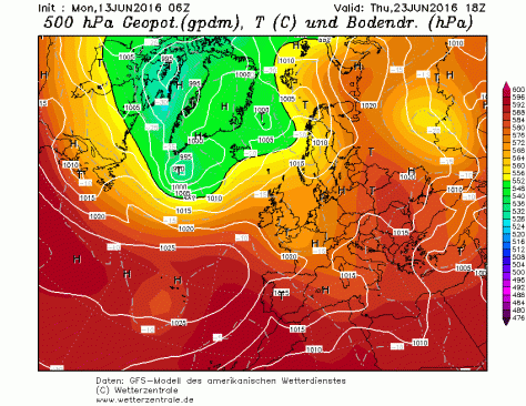
So what has August in store weatherwise? The models on the 1st suggest the month will start with a mixture of sunshine and showers. At the end of this week there are indications of a change to warm and later very warm weather.

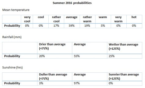
Beyond the grasp of the models my long range outlook method is hampered this month because of the very dry July. However, the data I do have suggests a rather warm month at 50 per cent probability. The ‘worst case’ scenario suggests something average, a contrast to  the past couple of Augusts which have been poor. Perhaps we can look forward to another reasonable summer month, defined by plenty of fine, at times hot, weather – though anyone looking for unending days of 30C and higher will be disappointed.

A dryer than average month (possibly very dry) looks most likely at 50% probability. A very sunny month looks most probable.

So to sum up: mean 19C (0.8C above average), rainfall 30.3mm (60%), sunshine 239 hours (123%).

hottest dayMy July outlook for temperature was good. I predicted a mean of 18.8C (outcome: 19.5C). Rainfall was very poor: 50mm (outcome: 17.3mm). Sunshine not badr: 171.9 hours (outcome: 190 hours).

Here follows the full weather diary for July…Full stats for the month here:http://1drv.ms/1rSfT7Y

1st: Cloudy with sunny intervals. Some sharp showers.
2nd: Bright start though breezy. Very heavy shower at 1740.
3rd: Sunny though with lots of cumulus.
4th: Sunny, gin clear start though cumulus rolled in at 1.30pm.
5th: Cloudy start with very brief, very light drizzle though with sunny breaks developing.
6th: Hazy mix of cirrus and cumulus gradually decreased to a clear sky by 1pm. More cumulus bubbled up later but still mostly sunny and low humidity.
7th: Sunny start with lots of cumulus, cirrus and stratus around. Sunny spells through the day.
8th: Cloudy and breezy start.hants
9th: Bright start with sunny spells but also lots of cloud. Amazing sunset with fronts coming in.
1oth: Cloudy start with light rain spreading in but only lasting for 40 minutes. Some sunshine in the afternoon though was breezy.
11th: Cloudy start with heavy showers early afternoon.
12th: Sunny start though with plenty of cloud which bubbled up and gave heavy showers from 11.30am. More showers in the afternoon – miserable.
13th: Bright and sunny to start that cloud gradually built before heavy showers hit at 2pm, these lighter over Aldersbrook.
14th: Sunny, bright start with sunny spells, tending to turn cloudier.
15th: Bright start but cloud piled in and breeze picked up.
16th: Sunny start with lots of cirro-cumulus. Cloud tended to build at times and a front passed over at 4pm. Warm evening and night.
17th: Bright start though with lots of heavy cumulus around. This tended to break up at intervals during the day, making it feel hot in the sun because of the high humidity.
18th: Sunny start with patchy cirrus and cumulus. This decreased as day wore on leaving a hot day. Felt almost airless with variable cloud.
19th: Sunny with decreasing cirrus to start to leave a gin clear day. Breeze picked up at noon meaning it wasn’t as warm as it could have been.
20th: Sunny but hazy start but with more of a breeze than yesterday. Cloud tended to fill in but then burnt off to leave another hot day.
21st: Sunny but cooler start than yesterday with lots of milky cumulus around.
22nd: Cloudy start after overnight rain. Sun breaking through at 12.30pm.
23rd: Cloudy start with spots of drizzle at 11am then slowy getting brighter with evening sunshine.
24th: Cloudy start with early showers breaking to sunny spells.
25th: Sunny start with variable amounts of cloud through the day. Feeling cooler.
26th: Sunny start though with cloud bubbling up through the morning. Overcast by 2pm.
27th: Cloudy and damp with light rain before and after obs time.
28th: Sunny periods with variable cumulus
29th: Cloudy start with brief rain showers in Chigwell. Sky broke to allow long sunny spells before it clouded over again. Rain shower at 9pm.
30th: Cloudy and overcast start. Long sunny spells into the afternoon.
31st: Sunny start though more cloud tending to bubble up in the afternoon.

London to Dunwich by bike in the dark

Hypnotised by a long line of red lights and a sudden feeling of being totally alone in the darkness were surreal sensations I experienced as I took on the challenge of the Dunwich Dynamo last weekend.start

I’d read a few personal accounts of this 120-mile blast through the Essex and Suffolk countryside but nothing really prepares you for the ride that starts in the fading light of East London.

A sea of cyclists greeted you as you arrive in London Fields – a mix of serious lycra together with quite a few souls in regular clothes who look as if they were popping down the shops for a pint of milk rather than an overnight ride to the coast. The park was also still busy with people out enjoying the warm weather with the thermometer still hovering around 25C. Though the event has been running for 24 years a couple of bemused onlookers asked me “what the hell is going on”.

“This is NOT a race”, screams the first line of a sheet of A4 directions handed to me by one of the organisers. And without any fanfare, at 8pm, legions got on their bikes by the Pub on the Park. My intentions of grabbing a big bowl of pasta before the start were soon forgotten as I joined the throng making its way through the narrow confines of Martello Street bike path.

The procession through Hackney was not everyone’s idea of fun though the sheer number of cycles was enough to stave off even the most impatient motorists.

epping
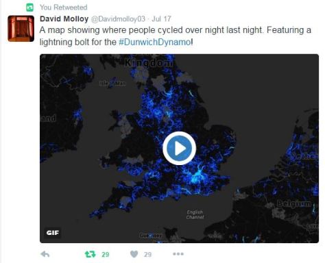
East London quickly turned into suburban Essex and the scrum of cyclists had already turned into a single file. The sun was already set by the time we reached the Wake Arms roundabout though I assured my two cycling buddies that there would be plenty of options for pasta and coffee in Epping – noble intentions that ended up as pork pies and cans of Coke from Londis…

I’d never cycled beyond Epping – unknown roads even harder to navigate in the darkness. Familiar names started to flash past: Moreton, Fyfield, Leaden Roding and the 32-mile point Great Dunmow. Pockets of villagers screamed encouragement at cyclists including a four-person handbuilt contraption, tandems and one brave cyclist who’d brought his child along in a trailer.

nags head moretonWe stopped for a pint in Great Bardfield at 43 miles; locals joining in the party atmosphere as cyclists either stopped or pedalled on. Although just gone midnight conversations seemed to hover over the fast pace of the tour, probably helped by the fine weather and almost constant light westerly breeze. Finchingfield, Wethersfield, Sible and Castle Hedingham then passed in quick succession before we reached the halfway point at Sudbury about 1am where huge queues had formed for coffee and a barbeque put on by the local fire crews.

Though the temperature never fell below 16C over the entire event tiredness was now starting to set in but before we got too ensconced in our chairs we decided to push on.

sudburyIt was this part of the event where groups of cyclists started to spread out though, because most were cycling at roughly the same speed, you started to notice the same people: the guy in the Heinz baked beans top, the group cycling for Alzheimers, the guy with the kiddie trailer (again) comes into view, the child still awake and appearing to be transfixed by a tablet. I exchanged pleasantries with a guy in a top with the dragon of Wales emblazoned on the back – inane conversations though most seem happy to just get their heads down and eat up a few more miles.

martin sizewell
Sizewell B is getting closer

It was around Bildeston that the roads suddenly seemed to turn really dark. Pedalling on I focus on the line of red lights in the distance – almost hynotised by the rhythm of the whole thing – but then suddenly realised that I was cycling downhill at roughly the same speed as I would in daylight. I turned my head to find that my two cycling buddies were nowhere to be seen, and neither were any other riders. An overwhelming feeling of being alone suddenly dawned on me and I eased back on the pedals though it was a good 10 minutes before my companions catch up – one asked just what exactly was in the muesli bars that I had been munching away on for six hours.

At 3am the delirium started to set in: the University Challenge theme tune was going on a loop in my head – a couple of cyclists that have brought along loud speakers failed to distract me. Our charge to the coast was eventually interrupted by a puncture, my cycling buddy exclaiming in the darkness: “This wheel doesn’t feel right!”.

moretonBy 4am the sky had long begun to lighten and the fading batteries of many riders’ headlamps was no longer such a pressing issue. I think it was around Sibton Lake that pop-up cafes started to emerge at the side of the road. Alas, the long queues prevented us from stopping, so terrified were we that if we stopped for too long our bodies would cease up. No matter. Many other cyclists by now were beginning to stop and rest on verges; a few oblivious that the sun was beginning to rise as quick as they were falling into a slumber.

framlinghamDunwichThe last 10 miles from Framlingham, once the sun had risen, seemed to be the hardest. I’m not sure if it was my brain being unable to cope with the additional distraction of having to deal with looking at beautiful countryside. And a couple more inclines seemed to be the last straw for a few cyclists who got off and walked.

The pine scrub of Minsmere spread out after passing through Darsham before our ultimate destination Dunwich, the Lost City, ended our odyssey. After 10-and-a-half hours we’d done it.

beacg
I’ve managed to raise over £1,000 for Sarcoma, the soft tissue and bone cancer charity

strava

sulston


Synoptic similarity: 2 hot days compared

synoptic

A link to the actual word document can be found here: https://1drv.ms/w/s!Au79-nZSg0ihlDSwLH2fQVGLWBNK

June 2016: extremely wet, dullest on record

Storm clouds gathering was a common sight in June 2016, but enough about the tumultuous political situation…

lake
The levels of Heronry pond have benefited immensely from the rainfall which was 2.5 times the average in June

For anyone looking for summery weather there was little to cheer about. For sunshine the month was the dullest June in a record going back to 1797. Just 96 hrs were recorded – which is just over half what we can expect in an average June.

Most notable was the rainfall: just over 139mm fell which is 272 per cent of average, and the third wettest since 1797. Only 1903 and 1860 were wetter. The month also saw the record broken for highest daily rainfall in a 24-hour period. A multi-cell thunderstorm in the early hours of the 23rd saw 60.8mm fall, most of it in two hours, bringing flash floods to the surrounding area.

fax
The synoptic situation at midnight on June 23 when the heaviest rainfall this area has seen since at least 1960 fell

With the lack of sunshine and copious rainfall it is, perhaps, surprising that the mean temperature for the month finished just above average: 16.8C is 0.7C above the June average. The warmest day was the 10th with 25.3C recorded – only one other day saw the mercury exceed 25C – very unusual for this time of years.

Air frosts: 0, Ground frosts: 0

So what has July got in store weatherwise? The models on the 1st suggest more of the same weather that we have seen during the last third of June. Sunshine and showers with the occasional ridge possibly calming things down for a few hours.

blake
Roads in Wanstead were turned into rivers in the early hours of June 23rd

Beyond the grasp of the models my long range outlook method suggests a rather warm month at 50 per cent – so given the cool start perhaps we can look forward to something summery in the final half to one third? Rainfall and sun looks inconclusive so I would guess average. Because of the high rainfall last month I think my long range method falls down.

A slightly wetter than average month looks most likely at 50% probability. Sunshine probably about average.

So to sum up: mean 18.8C (0.3C above average), rainfall 50mm, sunshine 190 hours.

My June outlook for temperature was good. I predicted a mean of 16.9C (outcome: 16.8C). Rainfall was very poor: 38mm (outcome: 139mm). Sunshine very poor: 178 hours (outcome: 96 hours).

Here follows the full weather diary for May…Full stats for the month here:http://1drv.ms/1rSfT7Y

1st: Cloudy and cool all day.
2nd: Cloudy and cold all day, brief brightness at 11am.
3rd: Cloudy and cool all day, limited brightness late morning. Cloudy overnight with limited breaks – air was very humid with warm front and visibility severely limited.
4th: Cloudy all day though cloud was lighter and air felt warmer because of the warm front that came in yesterday from Europe. Brief milky sunshine at 7pm.
5th: Cloudy up until 9.30am when the cloud began to thin. Sunny spells from 11am before a clearance at 1pm interspersed with occasional cloud.
6th: A gloriously sunny day all the way through. A lovely evening too.

sunsetflats
Sunny sunsets were rare in June

7th: Sunny start but cloud rolled in at 1.30pm with thunder heard all around Wanstead. Some serious flash flooding in Croydon. Highest official total was over 40mm in Kenley. Just 1.7mm during the day but trough brought rain at 5am, about 3mm.
8th: Sunny start but felt very humid and oppressive. A thunderstorm skirted Wanstead at 1.40pm with thunder and much rain in Chigwell, not much in Wanstead. More thunder at 2.10pm. Rain came and went for rest of day until 7pm – very little upper air movement. Mostly cloudy overnight.
9th: Cloudy start but some sunny spells developing.
10th: Cloudy start but soon decreased with long sunny spells developing. Lower humidity so felt pleasant.

chigwellrain
Heavy rain in Chigwell

11th: Cloudy and humid start with very heavy rain at 3pm. This lasted for 45 minutes. More rain fell sporadically through the day, evening and overnight.
12th: Cloudy after moderate rain. Showers and longer bursts of rain returned before a brief clearance at 3pm. More showers piled in with a real corker to the north of Wanstead.
13th: Damp start soon led to light rain, turning persistant at 11am. Then outbreaks of rain throughout the day, evening and overnight.
14th: Light rain to start but this quickly gave way to heavy showers all day. Some brightness at 6pm then turning drier overnight. Gin clear dawn.
15th: Sunny start but with lots of convective cloud. Some drizzle but a heavy shower stayed to the east of Ilford.
16th: Bright start with sunny spells, more breeze than recent days
17th: Lots of cloud around though sunny spells arrived early afternoon. Then showers between 5 and 6pm.
18th: Cloudy with spots of drizzle. Feeling cold all day – a maximum of only 16.5C.
19th: Sunny start but cloud gradually increasing all afternoon. Rain by nightfall that fell intermittently for hours. Rain again at obs time.
20th: Rain to start that lasted, with variable intensity, through the morning. Sunny spells from mid afternoon.
21st: Sunny start with just a few cirrus and cumulus, this tending to increase through the morning to leave an overcast afternoon. Cloudy overnight – a few spots of drizzle on school run as frontal wave started to move across UK.
22nd: Cloudy start with warm sector drizzle. Showers developed at 11pm, much thunder and lightning and the rain turned really heavy through the early hours.

rainjune
Extremely heavy rainfall during the early hours of the 23rd

23rd: Cloudy and humid to 1pm. Showers at 3pm.
24th: Sunny with variable cloud. Feeling humid in the sunshine.
25th: Bright start with sunny intervals. Light shower at midday. Thunderstorms at 2pm, 4pm and 9.30pm.
26th: Sunny spells though significant cloud at times. Rain between 4 and 6pm.
27th: Mostly cloudy though with some brightness after noon. Warmest point was in the evening at 7pm.
28th: Bright though cloudy start. Some sunny intervals but rain late afternoon into the evening. Cool overnight.
29th: Cloudy and breezy, some rain in the air early afternoon and again in the early hours
30th: Cloudy with slight breeze. Some light rain in the early hours.

London’s choked by leaving the EU

This month marks the 60th anniversary of the Clean Air Act, a piece of government legislation prompted in part by the Great Smog of December 1952 that caused between 4,000 and 12,000 premature deaths.boris

Air quality in the capital has vastly improved since those days of ‘pea souper’ fogs. A study of sunshine in Greenwich and other sites around east London reveals that winter months are, on average, around 18 per cent sunnier today than they were in the same period before the act was implemented in 1956. Though the cause of this is possibly partly because of a decline in winter anticyclones – weather systems that can give weeks of dull, murky conditions – further environmental legislation has helped.

Though the sky is clearer conditions at street level have grown steadily worse in recent years. During the first week of 2016 it was revealed that parts of the capital had already breached annual EU hourly limits for nitrogen dioxide – a pollutant that causes thousands of premature deaths through respiratory problems each year. A study last year showed that nearly 9,500 people die early each year in London because of long-term exposure to air pollution, more than twice as many as previously thought, according to the research.

Although action is being taken to reduce pollution from diesel buses, taxis and lorries the figures reveal that we are once again getting to the level of deaths caused by the Great Smog. The new mayor of London, Sadiq Khan, seems to be taking pollution a lot more seriously than his predecessor with a number of initiatives announced – making London compliant with EU legal limits well before the government’s target of 2025.

However, the mayor has also sent out conflicting messages by saying he backs the expansion of City Airport – you can’t have it both ways. And, if we do leave the EU, what will replace these EU legal limits?

With the current political situation lurching from one disaster to another I fear that the environment will get pushed well down the agenda. The current list of candidates vying to take over from David Cameron as prime minister include ‘dark horse’ Andrea Leadsom, the energy and climate change minister, who has been an ardent supporter of fracking. And on coal she recently sparked controversy in February  where she assured the industry the pledged 2025 coal phase-out was just a consultation and encouraged it to suggest what ‘unabated coal’ means.

The many benefits of EU membership got lost in the debate over the last few weeks – improvement in the environment being one of them. It is why, without the beady eye of Brussels keeping watch over us, that we must ensure that the next government stick to their promise of continual improvement to the capital’s air quality.

East london winter sunshine totals
Winter sunshine totals were falling before we joined the EU. Since 1973 a general upswing is observed. On average there is 18% more sunshine during winter months since we joined the EU compared with the same period before joining the Common Market


June weather can be flaming horror show

The past week has produced the highest 24-hour rainfall total recorded in Wanstead since at least 1960. The multi-cell thunderstorm on Wednesday night saw 60.8mm fall, most of it in two hours, bringing flash floods to the surrounding area. The spectacular lightning and thunder that accompanied it was almost a side show such was the intensity of the rainfall.

rainradar
An image from the Home & Dry app revealed a succession of dark red echoes passing over our area. The heaviest rain seemed to run on a line from Battersea to Romford

I was unfortunate enough to be riding home right in the middle of the event: the entire length of the Mile End Road bore a resemblance to a shallow river, the heavy rainfall bouncing back off the Tarmac high enough to create what felt like a powerful drench shower.

The legacy of the downpours caused chaos in the morning and evening rush-hours. Many commuters were stranded at London terminals including Waterloo station because of flooded tracks, possibly robbing many of the chance of voting in the EU referendum. It will never be known if this would have had a bearing on the final result.

Many people think of June as a warm, summery month. The term Flaming June  is regarded in most peoples’ subconscious as a reference to past weather. That it is a actually the name of a painting is often missed. Looking back through our local history there has been many notable events of thunderstorms and prolonged rainfall. In 1903 a record-breaking 59-hour deluge left vast swaths of the borough inundated.

list
The offical UK weather station totals all recorded less than Wanstead

This weekend 200 years ago, during the Year Without a Summer, a powerful tornado, strong enough to carry away objects weighing 60lbs, tore through the Edgware Road area in west London. Luke Howard recorded the event in the Climate of London.

At two o’clock being a still sultry day a whirlwind passed over the nursery ground of Mr Henderson in the Edgware Road which lifted seven lights from the greenhouses and carried them to the height of the highest elm trees, each of the lights weighs 50 or 60lbs at least. At the same time two garden mats were carried to an immense height so that the eye could not distinguish them.

The following day “extremely heavy and prolonged rain from 9am (26th) to 9am on 27th gave 2.95 inches”. This total of over 52mm is notably high though not a record.

This weather was a continuation of what had been an awful May and June – cold with more than twice the average rainfall in June.

The weather then was not unlike what we have experienced this month. Indeed, a look at the weather throughout this year was similar as this graph shows.

compared

Though the mean temperature at times bears a close resemblance this year is no comparison to 1816: The mean then was running at 6.2C, over 3 degrees colder than today.
Mean pressure was also lower being 992.1mb; the 2016 mean 9am pressure is 1010.6mb.
Perhaps not surprisingly this year’s rainfall rainradar
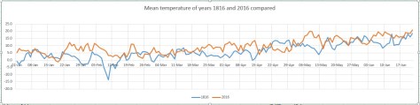
actually trumps 200 years ago; the running total for rainfall here is 390.1mm, higher than the 309.6mm recorded in 1816.

The dreary summer and frequent thunderstorms of 1816 inspired Mary Shelley to write Frankenstein. A summer vacation in Switzerland led her to spend much of the time indoors. She, along with Lord Byron and John William Polidori entertained each other with a contest to write the scariest story of all. The unseasonal conditions, along with this dare, led to the creation of Shelley’s Frankenstein: The Modern Prometheus— as well as Polidori’s novella The Vampyre and Byron’s long-form poem, The Darkness.

It will be interesting to see if this June’s weather, along with momentous political changes here and in Europe, produce more fine fiction from the this and the next generation of writers.

wind
Wind speed during the event from 2300 to 1000
temp
Temperature during the event from 2300 to 1000
pressure
Pressure during the event from 2300 to 1000
raintoday
Rainfall from 2300 to 1000
tipper
Rainfall rate from 2300 to 1000


Brexit to bring back those halcyon summers

I’m joking. But with the lies and half-truths spouted by both sides of the EU referendum debate it is a statement I wouldn’t be surprised to hear uttered in this last full week of campaigning before June 23.

This preposterous statement, however, got me thinking that perhaps there may be some truth that summers really were better before Britain joined the then European Economic Community with Denmark and Ireland in 1973.

But comparing the past 43 London summers with the period of summers from 1930-1972 shows that this is not the case in terms of temperature and rainfall.

Screen Shot 2016-06-13 at 13.17.20
Summers during the period 1973-2015 are on average 0.8C warmer than summers 1930-1972
Screen Shot 2016-06-13 at 13.22.19
A look at rainfall shows the average since 1973 is 84% that of the period 1930-1972
Screen Shot 2016-06-13 at 13.35.47
Average sun since 1973 is broadly the same as period 1930-1972 though has recently dipped

Perhaps it is just our minds playing tricks on us when we think back to summers being better than what they are today, and before EU membership?

Voter turnout and the weather

Over the years it has been argued that weather can affect voter turnout and therefore the result of an election. One Dutch study states: “We find that the weather parameters indeed affect voter turnout. Election-day rainfall of roughly 25 mm (1 inch) reduces turnout by a rate of one per cent, whereas a 10-degree-Celsius increase in temperature correlates with an increase of almost one percent in overall turnout. One hundred percent sunshine corresponds to a one and a half percent greater voter turnout compared to zero sunshine.”

Screen Shot 2016-06-13 at 14.24.26
Weather for the referendum on June 5, 1975, was mostly fine nationwide. A temperature of 21.3C was recorded at Greenwich after an overnight low of 7C. It was the start of a settled period of summer weather that had followed a cool and miserable late May and early June. Sound familiar?

In June 1975 the electorate expressed significant support for EEC membership, with 67 per cent in favour on a 65 per cent turnout. Though the turnout looks low you certainly couldn’t blame the weather.

In terms of this year, with ten days to go, it is too early to say for sure what the weather will be like on June 23rd though the GFS model suggests, like 1975, it could be the start of a more settled spell of weather?

ridge
There are signs that the Azores high may ridge north-eastwards around June 23rd, possibly bringing fine weather for referendum day 

Weather forecasting and the European Union

Weather forecasts have improved immensely since the 1970s. A three-day forecast is now much more accurate than a 24-hour forecast was in the 1980s, partly thanks to the collaboration between national met agencies throughout Europe and beyond.

The European Centre for Medium-Range Weather Forecasting (ECMWF), formed in 1975 as an intergovernmental organisation located in Reading, UK, will maintain its independence in the event of Brexit.

A spokesperson for ECMWF said: “While most of ECMWF’s member states are also members of the EU, ECMWF is structurally independent of the EU. The location of ECMWF in the UK, as well as the UK financial contributions to ECMWF and the tax arrangements between ECMWF and the UK are regulated by agreements between the ECMWF, its member states and the UK. These arrangements are entirely separate from the UK’s EU membership.”

There’s a huge amount riding on this referendum. The EU has flaws but there’s far more good comes out of it than bad. And even if the EU has too many technocrats and bureaucrats I’d rather entrust funding to them than the short-term policy making that plagues modern Westminster on both sides of the political spectrum. And that’s why I’ll be voting Remain.


Summer forecast 2016: yo-yo weather

The cold start to June may soon be a distant memory once summer proper gets going in east London. But rather than a succession of prolonged hot, dry spells it’s looking like the season overall will be broadly average – you will hear the old saying: ‘an English summer consists of three fine days and a thunderstorm’ more than once this year.

Heavy shower cloud looking east over Wanstead Flats
Three fine days and a thunderstorm – the typical English summer

Looking at summers back to 1799 I’ve tried to find a pattern linked with a declining El Nino. And failed to find anything conclusive. With ENSO forecast to be approaching neutral by August I decided to discount it completely, instead relying on pattern matching of meteorological data from this area for March, April and May stretching back to 1799.

The mean for the spring season was 10C with 156.4mm of rain and 455 hours of sunshine.

If you take into account all years that were within +/- 10 per cent of these figures, for rainfall and then mean temperature, some 36 ‘best fit’ years emerged, far more than my previous two attempts to forecast summer. The years, ranging from 1805 through to 2007, saw all manner of summers – only one was a real corker, 1825, but most were fairly nondescript average affairs. As an average this summer could be expressed as: Mean: 16.7C (just above average) Rainfall: 166mm (exactly average) Sunshine: 546hrs (about average)

Or, expressed in probabilities, I concluded the following:

summer 2016 probs


From the above you could deduce that the next three months will be slightly warmer than average, with average rainfall and sunshine.

Last year I tried to decipher, with fair success, when hot spells would occur. However,  looking at the data of these 36 summers very warm, dry spells happened through the three months – it was impossible to find any exact pattern to when it would be warm and dry.

Instead I’ve broken down the summer into June, July and August probabilities.

Looking at June, considering this cool and cloudy start, I would guess that we can look forward to a few very warm, thundery spells – a repeat of the Spanish plumes of the past couple of years.

june 2016 probs

Considering the above data perhaps there is a greater than evens chance of some thundery activity – and the nature of thunderstorms mean you can get a deluge or stay relatively dry / average. Sunshine average.

On to July. After a ‘rather warm’ June I wonder if the ‘return of the westerlies’ will happen just in time to affect this month?

July 2016 probs

The above chart would suggest that July will be classically average overall. Fine, not too hot spells, with occasional depressions bringing cooler weather and showers.

On to August. This month has been a real disappointment the past couple of years. However, I think this year August may offer a bit more in the way of sunny weather.

August 2016 probs

Looking at the above probabilities there seems a fair chance of something average to rather warm overall. With rainfall below average and average sunshine I wonder if there will be two or three fine spells throughout August – perhaps more?

So, all-in-all, summer looks a mixed bag. How this summer will fair obviously only time will tell. One could argue that what I’m forecasting is just climatology which has a good chance of being correct should no external influences, such as a huge eruption on Mount Etna, have a bearing on the end result.

* Taking into account the fact that temperatures in London are up to 0.66C warmer than they were 100 years ago I have added 0.66C to mean temperatures before 1915.

** Obviously, in the event of a series of direct hits from thunderstorms, my rainfall estimate could be hopelessly short – a symptom of abundant solar energy at this time of year which creates a ‘noisy’ atmosphere compared with winter.

*** The 1981-2010 average mean for summer in this region is 17.6C, with 144.9mm of rain and 564 hours of sunshine

May 2016: rather mild with average rain

A stunning first week of weather in May 2016 probably led a few people into believing that we were in for a glorious start to the summer. But the second Sunday in the month when temperatures reached 27.1C under 13 hours of sunshine was about as good as it got.

view
May 10th 2016 looking toward Crown Hill from Dunton in Essex

The warm first week helped maintain the mean temperature to finish above average: 14.3 which is 1.2C warmer than average, the warmest May for five years.

Though on paper rainfall looked a little under average 44 per cent of the monthly total fell on the last day. Some 43.4mm fell during the course of the month, that’s 85% of what we can expect during a normal May.

Sunshine was about average. Some 184.5 hours were were recorded, 101% of what we can expect to see during an average May.

The wettest day occurred during the meteorological 24hrs of the 30th (09-09 31st) with 14.7mm, rain associated with a depression in the North Sea. Incessant cloud held temperatures down to 12.6C, the coldest May 31st for 36 years!

convey
A conveyor belt of rain brought the coldest May 31st for 36 years

Air frosts: 0, Ground frosts: 5

So what has June got in store weatherwise? The models on the 1st suggest only slow changes in the next 3-4 days. These changes revolve around the release of low pressure from Europe towards high pressure later next week. This process begins as high pressure also begins to build down from the north at the weekend with several days of fine and increasingly warm conditions as the cool NE’ly flow is lost to warmer winds from the SE or south. Then next week with higher pressure over Europe and low pressure drifting slowly north or NE towards the west of the UK it could become very warm and humid in places and as that low to the west pushes troughs towards us from the SW it could feed some thundery rain and storms up from the SW at some stage by midweek. The pattern thereafter appears quite mixed. GFS suggests a more traditional pattern of low pressure to the NW and higher pressure to the SE with SW bringing rain at times to the north and west while the south and east see the best of prolonged dry and warm periods between intermittent rain.

high
High pressure to the north of Scotland brought often miserable, overcast weather to our region

Beyond the grasp of the models my long range outlook method suggests an average to rather mild month. The highest probability is 29% for something a little above average and rather mild. A little below average and mild both come in at 14% probability. Something cool or very cool comes in at 7%. If you combine the first two probabilities together something just over average would come in at 58%

A dryer than average month looks most likely at 57% probability. Sunshine probably about average.

So to sum up: mean 16.9C (0.8C above average), rainfall 38mm, sunshine 178 hours.

My May outlook for temperature was poor. I predicted a mean of 12.8C (outcome: 14.3C). Rainfall was also poor: 58mm (outcome: 43mm). Sunshine was good: 184.5 hours (outcome: 179 hours).


Here follows the full weather diary for May…Full stats for the month here:http://1drv.ms/1rSfT7Y

1st: Sunny start though with cirro cumulus around. Cloud tended to thicken up through the day to leave overcast late afternoon. A warm night followed.
2nd: Cloudy with spits and spots of rain to start. Some bright spells late morning but then overcast and some rain at 6.40pm – a decaying front gave little rain. Clearing overnight and cold.
3rd: Sunny with fair weather cumulus developing.
4th: Sunny, gin clear start with just a few fair weather cumulus developing. Clear and cold overnight.
5th: Sunny and warm, some hazy cloud in the afternoon.
6th: Sunny start though turned much more hazy than yesterday. Feeling humid.
7th: Hazy sunshine to start with high level strato-cumulus bringing cloudier periods.
8th Sunny start with just a few clouds. Air much clearer than yesterday and hot by mid afternoon on Canary Wharf.
9th: Cloudy start but became sunny late morning. Rain arrived 5pm, turning moderate 7.30pm and outbreaks through the night.
10th: Light rain to start, this turning moderate at times throughout the day, though petering out at 2.30pm.
11th: Dull, damp start that went into 11am. Heavy showers developing that lasted until late afternoon.
12th: Sunny start though with a fair bit of cirro cumulus floating around. Feeling very warm.
13th: Sunny start with spotted cirro cumulus. A pleasant day.
14th: Bright start with sunny spells into the morning. Cold wind took edge off sunshine.
15th: Sunny and cool with a cool breeze.
16th: Sunny start but quickly clouded over. Bright spells into the afternoon.
17th: Sunny start but cloud soon filled in. Sunny periods around lunchtime before more cloud arrived.
18th: Cloudy start after recent light rain. Bursts of rain at 11.20am, turning heavy at 12.30pm. Some more rain at midnight.
19th: Cloudy with brief sunny intervals before noon. Then cloudy.
20th: A Cloudy and breezy day. Feeling humid.
21st: Cloudy and breezy through the day though mild. Brief shower at 6pm while driving back from Broadstairs.
22nd: Sunny start though cloud increased during the day to fill in by 2.30pm. Showers, one moderate, from 6pm.
23rd: Sunny start but lots of cloud bubbled up. A lot of threatening cloud to west and east with funnel cloud spotted over Leighton Buzzard. https://twitter.com/Chxrlie_Mxrch/status/734818236211068930 Cleared overnight to leave cold night.
24th: Sunny start quickly clouded over by 11am, then just sunny intervals
25th: Cloudy and cool all day thanks to HP bringing drift off North Sea.
26th: Sunny start with sunny spells though the day
27th: Cloudy start though with sunny spells developing at lunchtime and a clearance around 1pm – 2pm. More convective cloud bubbled up however, to leave a humid evening. Rain developing at 7am.
28th: Cloudy, damp start though with a little brightness at 11am. Some sunny intervals in the afternoon though much cloud.
29th: Cloudy and cool start. Hazy sunny spells in early afternoon, though still much cloud around.
30th: Cloudy with just two sunny intervals that momentarily lifted the temperature. Rain started at 7.30am and was heavy at times up to obs time. Elderly man killed on crossing, possibly due to the bad weather
31st: Rain to start. Outbreaks lasted up until 1315z then stayed cloudy, damp and chilly into the evening and night.


April 2016: rather cold and thundery

April 2016 has seen more occurrences of thunder than we can expect during a typical July.

radar hail
About an inch of hail collected on borders in gardens in Plaistow during a thunderstorm on 29th. This stuck around for over an hour thanks to the low humidity

A persistent flow of unstable Polar maritime air, coupled together with strong sunshine, provided the perfect ingredients for some really beefy showers.

The mean temperature of 9C was 0.8C cooler than average, the coldest April for three years and in stark contrast to the previous two Aprils that were mild and very dry. Air frost, notable for its absence in the previous two Aprils, returned with four incidences where the temperature dipped below freezing

Apart from a dry slot in the third week rainfall was fairly steady: 52.5mm is 124% of average for this area. It was the wettest April for four years.

bracka20160415
A depression on 15th led to the wettest 24hrs of April

Sunshine was just below average. Over 153 hours were recorded, 96% of what we can expect to see during an average April.

The wettest day occurred on the 15th with 15.9mm, rain associated with a depression that ran along the Channel coast out into the North Sea, a system that heralded the colder pattern that defined the rest of the month.

Air frosts: 4, Ground frosts: 12

So what has May got in store weatherwise? The models on the 1st suggest that rather warmer weather will develop as we finally lose the northerly-sourced airflow and low pressure across the UK.

hail radar
The radar on 29th shows a thunderstorm right over Plaistow to the south of Wanstead

Low pressure to the NW will become influential with strong and milder WSW winds driving wind and rain bearing fronts east and SE across the UK late on Sunday and Monday. A bright and brisk NWly flow with sunshine and showers then looks likely to be replaced by a ridge of high pressure and drier weather. It will begin to feel quite warm in any sunshine across the south from midweek.

Beyond that the outlook is uncertain though it appears warmer, if changeable, conditions will prevail.

Beyond the grasp of the models my long range outlook method has conflicting signals. The highest probability is 32% for something rather cool. Average is 28% while rather mild comes in at 20% probability. Something cool comes in at 12%, while mild is 8% probability. Both cool and very mild have a probability of just 4%.

A wetter than average month looks most likely at 48% probability. Sunshine probably about average.

So to sum up: Mean: 12.8C (0.2C below average), rainfall 58mm, sunshine 179 hours.

My April outlook for temperature was good. I predicted a mean of 9.2C (outcome: 9C). Rainfall was also good: 57mm (outcome: 52.5mm). Sunshine also good: 149 hours (outcome: 153.9 hours).

Here follows the full weather diary for April. To view full stats follow this link:http://1drv.ms/1kiTuzv

1st: Sunny start though lots of haze around from late morning.
2nd: Sunny until 2pm before cloud then light rain spread in – this lasting into the evening.
3rd: Sunny start with hazy cumulus building through the day.
4th: Bright start though lots of cloud around. Some gin clear spells of sunshine.
5th: Sunny start though with variable cloud through the morning.
6th: Drizzly start, giving way to sunny spells and showers.
7th: Cloudy after recent light rain. Windy and cold. Some heavy showers mid to late afternooon with flash of lightning and thunder at 4pm and hail >5mm.
8th: Bright start though with much cloud around. Some brief sunny spells and v light showers.
9th: Cloudy, damp start after morning rain. This broke to sunny spells at 1pm ish. Cloudy again later but clearing at dusk to allow a frosty night.
10th: Sunny start but soon turned hazy with keen, cold SE wind building through the day.
11th: Cloudy start but brief brightness early afternoon. Rain at 2.15pm – this lasted until 5pm. More rain in the early hours, heaviest just before 5am.
12th: Bright start though hazy with lots of cirruo stratus. Clear and cold overnight.
13th Glorious sunny start and warm in the sunshine. Some patchy cloud at times. More cloud bubbled up late afternoon with a shower at 8pm and midnight. Clear and cold overnight.
14th: Sunny start though with much more cloud at times to 2pm. Showery rain in the evening lasted through the night.
15th: Cloudy with rain at 9.45am until 10.15 then turned a bit brighter before cloudy again at 11.45am. Rain set in at 12.30pm with thunder at 1.07pm then rain on and off into the evening. Clearing overnight and cold.
16th: Cloudy and cold start. Stayed cloudy all day with brief light rain shower. Cold and frosty overnight.
17th: Sunny, gin clear start with cloud gradually bubbling up. Sunny periods throughout the day.
18th: Sunny start with cumulus bubbling up.
19th: Mostly sunny start but then turned very cloudy. This cloud cleared just before noon.
20th: Sunny, clear start with just a few cirrocumulus drifting around during the day. Cold wind.
21st: Bright start but much cloud around. Some spells of hazy sun through the afternoon.
22nd: Cloudy, cold feeling start. Rain by 5pm, this heavier than expected. Next day dawned clear but cloud soon bubbled up.
23rd: Sunny start, cloud bubbled up with a shower at 12.25pm, clearing by 1pm. Early rain on 24th before obs time.
24th: Bright start, cloud bubbled up with light shower at midnight.
25th: Cloudy, cold start with lots of Arctic cumulus. Showers soon arrived that were mostly sharp but brief and heavier in the east. These cleared to leave a cold, breezy night.
26th: Sunny start but cloud quickly bubbled up. Some heavy showers of soft hail with odd snow flake. Thunder at 2.45pm.
27th: Sunny start though cloud quickly started building with snow and soft hail at 12.30pm. Further showers at 1712 and 2330. Clear, cold and frosty overnight.
28th: Sunny and mostly clear up until  12 noon.
29th: Sunny start though cloud quickly bubbled up. Some very heavy hail in Plaistow with an accumulation of one inch – this hung around for a while due to the low dew point and low humidity – less in Wanstead. Thunder and lightning too.
30th: Sunny, clear start though cloud began to bubble up. Felt cold in the wind as it became overcast last afternoon. Cleared overnight to give frost.

bluebells
Another superb display of bluebells burst into life in Chalet Wood, Wanstead Park, this month